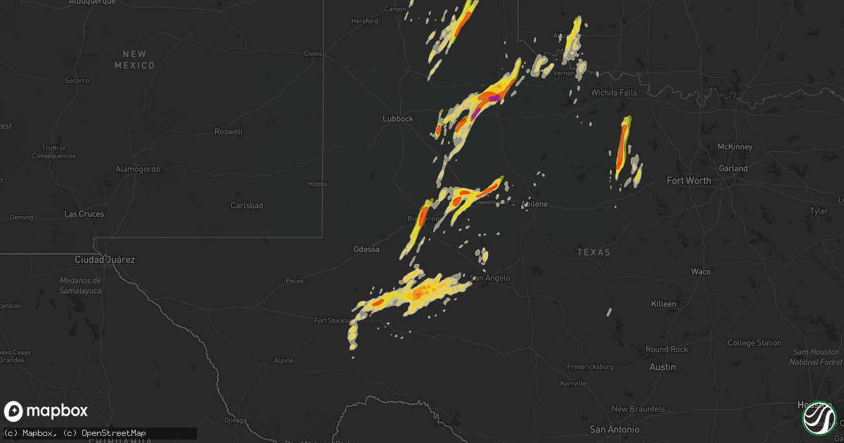
Hail Map on April 16, 2016
Get this storm
April 16 map
$229
one time, instant access
Download today. No call, no setup
Keep the $229
Bought the map and want the full workflow? Apply the entire $229 to a subscription within 7 days. None of it is wasted.
Every map, not just this one
This buys you this map. Subscription and you get every map we run, in the markets you choose from a few cities to whole states to nationwide. Plus real-time alerts the moment a storm fires.
Contact data
Name, contact info, occupancy, even credit band for addresses in the footprint. You go from where it hit to who to call.
Become the source they trust
Unlimited branding weather history reports on demand. You already have the documented answer ready for the property owner, and you are the one who showed up with it.
Property data and RoofTrace estimates
Pull up any address you have got, its value and the exact code rules for that jurisdiction, straight from One Click Code. Then RoofTrace estimates the squares, pitch, and roof value, priced the way you price.
Storm reports
Oklahoma
| Date | Description |
|---|---|
| 04/15/201610:42 PM CDT | A local report indicates 1.25 inch wind near 1 N HEADRICK |
Texas
| Date | Description |
|---|---|
| 04/16/20166:30 PM CDT | A local report indicates 2.00 inch wind near LONGWORTH |
| 04/16/20166:23 PM CDT | A local report indicates 1.00 inch wind near DUMONT |
| 04/16/20166:21 PM CDT | Report relayed via social media. |
| 04/16/20166:10 PM CDT | Dime to quarter size hail reported in big spring from 610 to 620 pm cdt. |
| 04/16/20166:10 PM CDT | A local report indicates 60 MPH wind near BIG SPRING |
| 04/16/20166:06 PM CDT | Hail between the size of quarters and ping pong balls was falling near lelia lake. |
| 04/16/20166:05 PM CDT | Video of a second but smaller tornado over open land. |
| 04/16/20166:00 PM CDT | A local report indicates 1.00 inch wind near 2 N SPUR |
| 04/16/20166:00 PM CDT | Gasoline pump blown over at chevron in big spring between 600 and 615 pm cdt. Report relayed by broadcast media via social media. |
| 04/16/20165:56 PM CDT | A local report indicates 1.25 inch wind near LELIA LAKE |
| 04/16/20165:55 PM CDT | 2 telephone poles and 3 irrigation pivots knocked down from strong winds. |
| 04/16/20165:50 PM CDT | Video of large cone tornado over open land. |
| 04/16/20165:50 PM CDT | A local report indicates 74 MPH wind near 1 SSE LOMAX |
| 04/16/20165:50 PM CDT | Hail to the size of golf balls was reported along highway 70 south of clarendon. |
| 04/16/20165:00 PM CDT | A local report indicates 1.00 inch wind near 7 N LORAINE |
| 04/16/20164:56 PM CDT | A local report indicates 1.00 inch wind near 5 S CLARENDON |
| 04/16/20164:55 PM CDT | A local report indicates a tornado near 9 SW GIRARD |
| 04/16/20164:45 PM CDT | Hail to the size of quarters fell south of clarendon along hwy 70. |
| 04/16/20164:30 PM CDT | A local report indicates 1.00 inch wind near COLORADO CITY |
| 04/16/20164:28 PM CDT | A local report indicates 1.25 inch wind near COLORADO CITY |
| 04/16/20164:25 PM CDT | A local report indicates 1.00 inch wind near COLORADO CITY |
| 04/16/20163:55 PM CDT | Old outbuilding collapsed. Time estimated from radar and west tx mesonet. |
| 04/16/20163:50 PM CDT | Measured by the west tx mesonet. |
| 04/16/20169:35 AM CDT | Security officer reported 2 power poles down and power outage on the rocker b ranch near county road 401 and highway 163. |
| 04/15/201611:34 PM CDT | A metal roof was blown off of a building at the west texas boys ranch. |
| 04/15/201610:50 PM CDT | Golfball size hail 12 miles west of graford |
| 04/15/20169:35 PM CDT | Security officer reported 2 power poles down and power outage on the rocker b ranch near county road 401 and highway 163. |
| 04/15/20168:17 PM CDT | A local report indicates 1.75 inch wind near 7 S PADUCAH |
| 04/15/20168:03 PM CDT | Reported at the intersection of county road 465 and fm1606. |
| 04/15/20168:01 PM CDT | Reported at the colorado city airport |
| 04/15/20168:00 PM CDT | A local report indicates 1.00 inch wind near 4 SE DUNN |
| 04/15/20167:58 PM CDT | Covering ground on us83 |
| 04/15/20167:50 PM CDT | Unknown intensity |
| 04/15/20167:41 PM CDT | 4 deep on us 83 |
| 04/15/20167:37 PM CDT | A local report indicates 1.75 inch wind near 1 S MCCAMEY |
| 04/15/20167:28 PM CDT | A local report indicates 2.00 inch wind near 2 W GROW |
| 04/15/20167:26 PM CDT | A local report indicates 1.75 inch wind near 7 S PADUCAH |
| 04/15/20167:21 PM CDT | A local report indicates 2.25 inch wind near 1 S GROW |
| 04/15/20167:20 PM CDT | A local report indicates 1.00 inch wind near 1 W FLUVANNA |
| 04/15/20167:15 PM CDT | A local report indicates 1.25 inch wind near 12 N GUTHRIE |
| 04/15/20167:12 PM CDT | A local report indicates 1.00 inch wind near MCCAMEY |
| 04/15/20167:00 PM CDT | Covering ground |
Cities Impacted by Hail Map on April 16, 2016
- Lockney, TX
- Roby, TX
- Roscoe, TX
- Loraine, TX
- Sweetwater, TX
- Snyder, TX
- Hermleigh, TX
- Ira, TX
- Sylvester, TX
- McCaulley, TX
- Colorado City, TX
- Westbrook, TX
- Spur, TX
- Graford, TX
- Crosbyton, TX
- Justiceburg, TX
- Quanah, TX
- Perrin, TX
- Palo Pinto, TX
- Santo, TX
- Mineral Wells, TX
- Big Lake, TX
- Harrold, TX
- Davidson, OK
- Big Spring, TX
- Fort Stockton, TX
- Childress, TX
- Trent, TX
- Holliday, TX
- Vernon, TX
- Chillicothe, TX
- Mertzon, TX
- Dickens, TX
- Clarendon, TX
- Lakeview, TX
- Silverton, TX
- Lelia Lake, TX
- Quitaque, TX
- Hedley, TX
- McCamey, TX
- Paducah, TX
- Ralls, TX
- Mountain Park, OK
- Roosevelt, OK
- Elmer, OK
- Snyder, OK
- Tipton, OK
- Headrick, OK
- Panhandle, TX
- Garden City, TX
- Rankin, TX
- Ozona, TX
- Midkiff, TX
- Bryson, TX
- Jacksboro, TX
- Jermyn, TX
- Henrietta, TX
- Strawn, TX
- Graham, TX
- Windthorst, TX
- Roaring Springs, TX
- Afton, TX
- Girard, TX
- Crowell, TX
- Robert Lee, TX
- Hugoton, KS
- Barnhart, TX
- Seymour, TX
- Imperial, TX
- Post, TX
- Pampa, TX
- Iraan, TX
- Electra, TX
- Happy, TX
- Frederick, OK
- Grandfield, OK
- Sunray, TX
- Midland, TX
- Claude, TX
- Amarillo, TX
- Crane, TX
- San Angelo, TX
- Gruver, TX
- Dumas, TX
- Coahoma, TX
- Altus, OK
- Anson, TX
- Abilene, TX
- Mobeetie, TX
- Fluvanna, TX
- Tye, TX
- Dyess Afb, TX
- Canyon, TX
- Wright, KS
- Canadian, TX
- Avoca, TX
- Lueders, TX
- Wayside, TX
- Mingus, TX
- Oklaunion, TX
- Blackwell, TX
- Dodge City, KS
- Eldorado, OK
- Sheffield, TX
- Gail, TX
- Mcadoo, TX
- Masterson, TX
- San Saba, TX
- Cherokee, TX