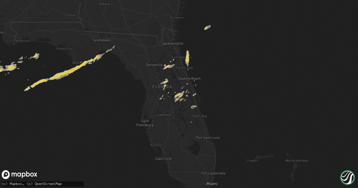
Hail Map on April 14, 2013
Get this storm
April 14 map
$229
one time, instant access
Download today. No call, no setup
Keep the $229
Bought the map and want the full workflow? Apply the entire $229 to a subscription within 7 days. None of it is wasted.
Every map, not just this one
This buys you this map. Subscription and you get every map we run, in the markets you choose from a few cities to whole states to nationwide. Plus real-time alerts the moment a storm fires.
Contact data
Name, contact info, occupancy, even credit band for addresses in the footprint. You go from where it hit to who to call.
Become the source they trust
Unlimited branding weather history reports on demand. You already have the documented answer ready for the property owner, and you are the one who showed up with it.
Property data and RoofTrace estimates
Pull up any address you have got, its value and the exact code rules for that jurisdiction, straight from One Click Code. Then RoofTrace estimates the squares, pitch, and roof value, priced the way you price.
Storm reports
Oklahoma
| Date | Description |
|---|---|
| 04/13/20137:06 PM CDT | A local report indicates 58 MPH wind near MULHALL |
Florida
| Date | Description |
|---|---|
| 04/14/20136:30 PM CDT | Trees and power lines down near chiefland and also near gulf hammock. |
| 04/14/20136:28 PM CDT | Central dispatch reported a tree down on 24th street. |
| 04/14/20136:25 PM CDT | Central dispatch reported a tree down on nw 66th blvd. |
| 04/14/20135:30 PM CDT | One inch diameter hail ne of ocklawaha |
| 04/14/20135:27 PM CDT | A trained spotter reported quarter sized hail at 625pm local in altamonte springs. |
| 04/14/20134:47 PM CDT | Central dispatch reported a tree and power lines down at birch street and lakeview trail. |
| 04/14/20133:15 PM CDT | Power line down on westcott circle |
| 04/14/20132:43 PM CDT | Quarter size hail and estimated wind gusts of 50 mph. |
| 04/14/20132:35 PM CDT | Trees and powerlines down in eastpoint. |
| 04/14/20132:33 PM CDT | Waterspout moved onshore causing minor damage in eastpoint. |
| 04/14/20132:30 PM CDT | Roof damage to two mobile homes in eastpoint from landfalling waterspout. |
Mississippi
| Date | Description |
|---|---|
| 04/14/20138:53 AM CDT | Multiple trees and power lines down along cuevas-delisle road. |
| 04/14/20138:39 AM CDT | Peak wind 33052kt/1339utc |
Alabama
| Date | Description |
|---|---|
| 04/14/201311:00 AM CDT | Tree down on route 104. Reported by baldwin ema. |
| 04/14/201310:45 AM CDT | Two large oak trees down against a house in gulf shores. |
| 04/14/201310:06 AM CDT | Power lines down on dauphin island parkway at river road. Radar measured 45 kts. |
| 04/14/201310:06 AM CDT | Power lines down on dauphin island parkway at river road. Radar measured 45 kts. |
| 04/14/20139:40 AM CDT | Power pole knocked down near grand bay. 46 mph estimate. |
Georgia
| Date | Description |
|---|---|
| 04/13/20139:30 PM CDT | Measured by the national estuarine research system observation site at sapelo island. |
| 04/13/20139:22 PM CDT | The island manager reported several trees down across the southwestern portion of the island. One tree down on a parked car. Damage to numerous aluminium signs. No inju |
| 04/13/20139:03 PM CDT | Police officers reported several large limbs down across the darien area. Size of limbs estimated at roughly 4 inches in diameter. Time estimated by radar. |
| 04/13/20138:47 PM CDT | Central dispatch reported numerous trees down in the thalmann area. |
| 04/13/20137:55 PM CDT | Dispatch reported multiple trees down county-wide. |
Cities Impacted by Hail Map on April 14, 2013
- Perkins, OK
- Carrabelle, FL
- Panacea, FL
- New Orleans, LA
- Apopka, FL
- Hawthorne, FL
- Interlachen, FL
- Palatka, FL
- Oviedo, FL
- Summerfield, FL
- Weirsdale, FL
- Lady Lake, FL
- Groveland, FL
- Webster, FL
- Center Hill, FL
- Stillwater, OK
- Mims, FL
- Titusville, FL
- Orlando, FL
- Ocoee, FL
- Howey In The Hills, FL
- Yalaha, FL
- Tavares, FL
- Eastpoint, FL
- Winter Springs, FL
- Sanford, FL
- Casselberry, FL
- Winter Garden, FL
- Winter Park, FL
- Longwood, FL
- Altamonte Springs, FL
- Maitland, FL
- Perry, FL
- Ocklawaha, FL
- The Villages, FL
- Fruitland Park, FL
- Geneva, FL
- Osteen, FL
- Satsuma, FL
- Fort McCoy, FL
- Citra, FL
- East Palatka, FL
- Ripley, OK
- Saint Cloud, FL
- Rockledge, FL
- Marrero, LA
- Westwego, LA
- Daytona Beach, FL
- Deland, FL
- New Smyrna Beach, FL
- Silver Springs, FL
- Ocala, FL
- Belleview, FL
- Kenansville, FL
- Orange City, FL
- Deltona, FL
- Debary, FL
- Gotha, FL
- Lake Mary, FL
- Windermere, FL
- Apalachicola, FL
- Green Cove Springs, FL