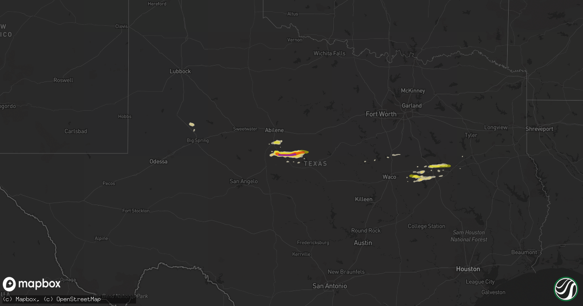
Hail Map on April 13, 2015
Get this storm
April 13 map
$229
one time, instant access
Download today. No call, no setup
Keep the $229
Bought the map and want the full workflow? Apply the entire $229 to a subscription within 7 days. None of it is wasted.
Every map, not just this one
This buys you this map. Subscription and you get every map we run, in the markets you choose from a few cities to whole states to nationwide. Plus real-time alerts the moment a storm fires.
Contact data
Name, contact info, occupancy, even credit band for addresses in the footprint. You go from where it hit to who to call.
Become the source they trust
Unlimited branding weather history reports on demand. You already have the documented answer ready for the property owner, and you are the one who showed up with it.
Property data and RoofTrace estimates
Pull up any address you have got, its value and the exact code rules for that jurisdiction, straight from One Click Code. Then RoofTrace estimates the squares, pitch, and roof value, priced the way you price.
Storm reports
Texas
| Date | Description |
|---|---|
| 04/13/20155:46 PM CDT | A local report indicates 1.00 inch wind near 3 S CROSS CUT |
| 04/13/20155:38 PM CDT | 1 mile north of groesbeck |
| 04/13/20155:35 PM CDT | Golf ball hail occurring at this time. |
| 04/13/20155:34 PM CDT | Hail slightly larger than quarters fell in groesbeck |
| 04/13/20154:35 PM CDT | A local report indicates 1.25 inch wind near NOVICE |
| 04/13/20154:19 PM CDT | Trained spotter reported quarter size hail with lots of rotation in the cloud. |
| 04/13/20151:00 PM CDT | Damage to buildings and vehicles at a pet food plant |
| 04/13/20156:35 AM CDT | Severaloutbuildings damaged in driscoll. Roof debris spread over a large area. |
| 04/13/20155:53 AM CDT | Powerlines down between skidmore and tynan |
| 04/13/20155:25 AM CDT | Large tree limbs blown down...estimated 60 mph winds. |
| 04/13/201512:59 AM CDT | Picture of large hail - at least quarter sized - on facebook. Time estimated by radar |
| 04/13/201512:00 AM CDT | Gas station island cover toppled. |
| 04/12/201511:55 PM CDT | Public report via twitter of hail larger than golf balls just outside of big wells. |
| 04/12/201511:10 PM CDT | A local report indicates 1.00 inch wind near 1 NNE CARRIZO SPRINGS |
| 04/12/20159:28 PM CDT | Broadcast media relayed report of golf ball size hail in bonnie view |
| 04/12/20159:01 PM CDT | Kcrp dual polar doppler radar supports this report |
| 04/12/20157:27 PM CDT | Quarter sized hail reported west of interstate 45 |
| 04/12/20157:27 PM CDT | A local report indicates 1.00 inch wind near 5 E TYNAN |
| 04/12/20157:20 PM CDT | A local report indicates 1.00 inch wind near 9 SSW TEAGUE |
| 04/12/20157:18 PM CDT | 3 large trees down |
Florida
| Date | Description |
|---|---|
| 04/13/20154:00 PM CDT | Tree fell on house on southwest pinemount road. |
| 04/13/201512:20 PM CDT | One tree down on road at royal palms parkway and rymfire drive. |
Mississippi
| Date | Description |
|---|---|
| 04/12/20158:05 PM CDT | Nws storm survey found an ef0 tornado with max winds of 85mph...max width of 50 yds and 1.2 mile path length. This weak tornado began in southeast walnut grove near gol |
| 04/12/20158:03 PM CDT | The roof of a shop and shed were damaged. A couple trees were downed. |
| 04/12/20157:46 PM CDT | Nws storm survey found an ef1 tornado with max winds of 95mph...max width of 100 yds and 1/2 mile path length. The tornado began in a wooded area...knocking down some t |
| 04/12/20157:35 PM CDT | Numerous trees downed along a 1/2 mile stretch near hattie wallace road. Shingles blown off a house on hattie wallace road and a barn behind the house was destroyed. |
| 04/12/20157:15 PM CDT | Sporadic tree and powerline damage reported along a path between lebanon pinegrove road and gary road. A few homes also sustained minor roof damage. Cell associated wit |
| 04/12/20157:15 PM CDT | Sporadic tree and powerline damage reported along a path between lebanon pinegrove road and springridge road. A few homes also sustained minor structural damage. Cell a |
Cities Impacted by Hail Map on April 13, 2015
- Woodsboro, TX
- Avon Park, FL
- Novice, TX
- Gail, TX
- Knott, TX
- San Ygnacio, TX
- Sandia, TX
- Carrizo Springs, TX
- Cotulla, TX
- Asherton, TX
- Big Wells, TX
- Taft, TX
- Abbeville, LA
- Abilene, TX
- Ovalo, TX
- Clyde, TX
- Tuscola, TX
- Teague, TX
- Zapata, TX
- Cross Plains, TX
- Burkett, TX
- Coleman, TX
- Jeanerette, LA
- George West, TX
- Calliham, TX
- Portland, TX
- Theriot, LA
- Tilden, TX
- Beeville, TX
- Sinton, TX
- Groesbeck, TX
- Hebbronville, TX
- Fairfield, TX
- Goldsboro, TX
- Tynan, TX
- Mathis, TX
- Skidmore, TX
- Port Sulphur, LA
- Hillsboro, TX
- Abbott, TX
- Mexia, TX
- Crystal City, TX
- Clifton, TX
- Kaplan, LA
- Concepcion, TX
- Alice, TX
- Donaldsonville, LA
- Rising Star, TX
- Winters, TX
- Brownwood, TX
- San Diego, TX
- Aransas Pass, TX
- Rockport, TX
- Gregory, TX
- Lawn, TX
- Port O'Connor, TX
- Malone, TX
- Bynum, TX
- Laredo, TX
- Thornton, TX
- Big Spring, TX
- Victoria, TX
- Gonzales, LA
- Belle Rose, LA
- Carville, LA
- Pierre Part, LA
- White Castle, LA
- Geismar, LA
- Darrow, LA
- Catarina, TX
- Odem, TX
- Donie, TX
- Jewett, TX
- Oakwood, TX
- Winter Park, FL
- Maitland, FL
- Buffalo, TX
- Corpus Christi, TX
- Robert Lee, TX
- Bangs, TX
- Santa Anna, TX
- Eagle Pass, TX
- Palestine, TX
- Tennessee Colony, TX
- Realitos, TX
- Ingleside, TX
- Robstown, TX
- Orange Grove, TX
- Wortham, TX
- Erath, LA
- Oviedo, FL
- Orlando, FL
- May, TX