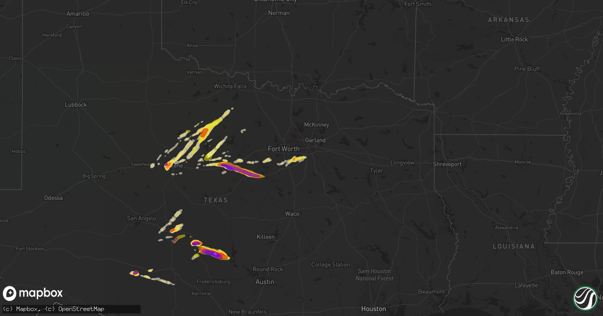
Hail Map on April 12, 2021
Get this storm
April 12 map
$229
one time, instant access
Download today. No call, no setup
Keep the $229
Bought the map and want the full workflow? Apply the entire $229 to a subscription within 7 days. None of it is wasted.
Every map, not just this one
This buys you this map. Subscription and you get every map we run, in the markets you choose from a few cities to whole states to nationwide. Plus real-time alerts the moment a storm fires.
Contact data
Name, contact info, occupancy, even credit band for addresses in the footprint. You go from where it hit to who to call.
Become the source they trust
Unlimited branding weather history reports on demand. You already have the documented answer ready for the property owner, and you are the one who showed up with it.
Property data and RoofTrace estimates
Pull up any address you have got, its value and the exact code rules for that jurisdiction, straight from One Click Code. Then RoofTrace estimates the squares, pitch, and roof value, priced the way you price.
Storm reports
Texas
| Date | Description |
|---|---|
| 04/12/20216:30 PM CDT | A local report indicates 1.75 inch wind near 3 W FREDONIA |
| 04/12/20216:19 PM CDT | Windshield of motor vehicle destroyed. |
| 04/12/20216:18 PM CDT | A local report indicates 2.75 inch wind near 1 WNW VOCA |
| 04/12/20216:12 PM CDT | A local report indicates 2.75 inch wind near VOCA |
| 04/12/20216:08 PM CDT | A local report indicates 1.75 inch wind near VOCA |
| 04/12/20216:06 PM CDT | Spotter estimated baseball to possibly up to grapefruit size hail southwest of voca at the intersection of county roads 216 and 218. Time estimated by radar. |
| 04/12/20216:04 PM CDT | A local report indicates 2.00 inch wind near 5 W VOCA |
| 04/12/20216:02 PM CDT | A local report indicates 1.50 inch wind near 5 W VOCA |
| 04/12/20215:45 PM CDT | A local report indicates 1.00 inch wind near 1 SW BRADY |
| 04/12/20216:32 AM CDT | At 1131 PM CDT, a severe thunderstorm was located 8 miles northeast of Woodson, or 14 miles east of Throckmorton, moving northeast at 35 mph. HAZARD...Half dollar size hail. SOURCE...Radar indicated. IMPACT...Damage to vehicles is possible. Locations impacted include... Olney and Newcastle. |
| 04/12/20216:26 AM CDT | At 1125 PM CDT, a severe thunderstorm was located near Salt Gap, or 19 miles northwest of Brady, moving northeast at 15 mph. HAZARD...Half dollar size hail. SOURCE...Radar indicated. IMPACT...Damage to vehicles is expected. This severe thunderstorm will be near... Pear Valley around 1135 PM CDT. Lohn around 1155 PM CDT. Waldrip around 1210 AM CDT. Rockwood around 1225 AM CDT.Other locations impacted by this severe thunderstorm include Us-283 Near The Mcculloch-Coleman County Line and Fife. |
| 04/12/20216:02 AM CDT | At 1102 PM CDT, a severe thunderstorm was located near Fort Griffin, or 10 miles northeast of Albany, moving northeast at 35 mph. HAZARD...Quarter size hail. SOURCE...Radar indicated. IMPACT...Damage to vehicles is expected. This severe thunderstorm will be near... Fort Griffin around 1110 PM CDT. Woodson around 1125 PM CDT.Other locations impacted by this severe thunderstorm include Lusk andThe Intersection Of Us-283 And Ranch Road 209. |
| 04/12/20215:42 AM CDT | At 1041 PM CDT, a severe thunderstorm was located near Telegraph, or 16 miles southwest of Junction, moving east at 30 mph. HAZARD...60 mph wind gusts and quarter size hail. SOURCE...Radar indicated. IMPACT...Hail damage to vehicles is expected. Expect wind damage to roofs, siding, and trees. Locations impacted include... Kerr Wildlife Management Area, Us-83 Near The Kerr- Kimble County Line, Us-377 Near The Kimble-Edwards County Line, I- 10 Near The Kimble-Kerr County Line and The Intersection Of I- 10 And Us 290. |
| 04/12/20215:35 AM CDT | At 1035 PM CDT, a severe thunderstorm was located near Salt Gap, or 21 miles west of Brady, moving east at 20 mph. HAZARD...Ping pong ball size hail. SOURCE...Radar indicated. IMPACT...People and animals outdoors will be injured. Expect damage to roofs, siding, windows, and vehicles. This severe thunderstorm will be near... Melvin around 1045 PM CDT. Salt Gap around 1050 PM CDT. Pear Valley around 1105 PM CDT. Lohn around 1115 PM CDT.Other locations impacted by this severe thunderstorm include TheIntersection Of Us-87 And Ranch Road 2134. |
| 04/12/20215:32 AM CDT | At 1032 PM CDT, a severe thunderstorm was located near Breckenridge, moving northeast at 30 mph. HAZARD...Quarter size hail. SOURCE...Radar indicated. IMPACT...Damage to vehicles is possible. Locations impacted include... Graham, Breckenridge, Necessity, Gunsight, Crystal Falls and Newcastle. |
| 04/12/20215:26 AM CDT | At 1026 PM CDT, a severe thunderstorm was located near Tye, or near Abilene, moving northeast at 35 mph. HAZARD...60 mph wind gusts and half dollar size hail. SOURCE...Radar indicated. IMPACT...Hail damage to vehicles is expected. Expect wind damage to roofs, siding, and trees. This severe thunderstorm will be near... Hawley around 1040 PM CDT. Abilene around 1045 PM CDT. Nugent around 1055 PM CDT. Lueders and Avoca around 1110 PM CDT.Other locations impacted by this severe thunderstorm include Impact,Hodges, Big Country Baptist Assembly, Lake Fort Phantom Hill and TheIntersection Of Us-180 And Farm Road 600.This includes Interstate 20 between Mile Markers 275 and 287. |
| 04/12/20214:58 AM CDT | At 958 PM CDT, a severe thunderstorm was located 12 miles southwest of Roosevelt, or 21 miles north of Rocksprings, moving east at 25 mph. HAZARD...Golf ball size hail. SOURCE...Radar indicated. IMPACT...People and animals outdoors will be injured. Expect damage to roofs, siding, windows, and vehicles. This severe thunderstorm will be near... Telegraph around 1030 PM CDT.Other locations impacted by this severe thunderstorm include Us-377 Near The Kimble-Edwards County Line. |
| 04/12/20213:56 AM CDT | A local report indicates 1.75 inch wind near 9 NE STEPHENVILLE |
| 04/12/20213:46 AM CDT | At 843 PM CDT, a severe thunderstorm was located 8 miles west of Roosevelt, or 25 miles west of Junction, moving northeast at 15 mph. A second severe thunderstorm was located 8 miles south of Sonora, and was moving east at 15 mph. HAZARD...Ping pong ball size hail is expected with both of these storms. SOURCE...Radar indicated. IMPACT...People and animals outdoors will be injured. Expect damage to roofs, siding, windows, and vehicles. This severe thunderstorm will be near... Roosevelt around 910 PM CDT.Other locations impacted by this severe thunderstorm include I-10 Near The Sutton-Kimble County Line and The Intersection Of Us-277 And Ranch Road 189.This includes Interstate 10 between Mile Markers 409 and 447. |
| 04/12/20212:53 AM CDT | At 752 PM CDT, a severe thunderstorm was located over Llano, moving east at 35 mph. HAZARD...Golf ball size hail and 60 mph wind gusts. SOURCE...Radar indicated. IMPACT...People and animals outdoors will be injured. Expect hail damage to roofs, siding, windows, and vehicles. Expect wind damage to roofs, siding, and trees. Locations impacted include... Burnet, Marble Falls, Kingsland, Llano, Buchanan Dam, Gainesville, Granite Shoals, Meadowlakes, Highland Haven, Inks Lake State Park, Lone Grove, Bluffton, Stolz, Longhorn Cavern State Park and Sunrise Beach Village. |
| 04/12/20212:50 AM CDT | Report from mping: ping pong ball |
| 04/12/20212:48 AM CDT | Report from mping: quarter |
| 04/12/20212:32 AM CDT | A local report indicates 2.50 inch wind near RANGER |
| 04/12/20212:00 AM CDT | At 659 PM CDT, a severe thunderstorm was located near Field Creek, or 16 miles east of Mason, moving east at 20 mph. This is a very dangerous storm. HAZARD...Baseball size hail and 60 mph wind gusts. SOURCE...Radar indicated. IMPACT...People and animals outdoors will be severely injured. Expect shattered windows, extensive damage to roofs, siding, and vehicles. Locations impacted include... Llano, Gainesville, Castell, Field Creek, Lone Grove, Stolz, Valley Spring and Oxford. |
| 04/12/20212:00 AM CDT | At 700 PM CDT, a severe thunderstorm was located near Mason, moving northeast at 15 mph. HAZARD...60 mph wind gusts and quarter size hail. SOURCE...Radar indicated. IMPACT...Hail damage to vehicles is expected. Expect wind damage to roofs, siding, and trees. This severe thunderstorm will be near... Mason around 710 PM CDT.Other locations impacted by this severe thunderstorm includeKoockville. |
| 04/12/20211:30 AM CDT | At 629 PM CDT, a severe thunderstorm was located near Art, or 9 miles northeast of Mason, moving northeast at 15 mph. HAZARD...60 mph wind gusts and half dollar size hail. SOURCE...Radar indicated. IMPACT...Hail damage to vehicles is expected. Expect wind damage to roofs, siding, and trees. Locations impacted include... Valley Spring and Field Creek. |
| 04/12/20211:27 AM CDT | At 626 PM CDT, a severe thunderstorm was located near Art, or 8 miles northeast of Mason, moving east at 20 mph. HAZARD...60 mph wind gusts and quarter size hail. SOURCE...Radar indicated. IMPACT...Hail damage to vehicles is expected. Expect wind damage to roofs, siding, and trees. This severe thunderstorm will be near... Pontotoc around 655 PM CDT. |
| 04/12/20211:11 AM CDT | At 609 PM CDT, a severe thunderstorm was located over Camp San Saba, or 12 miles southeast of Brady, moving east at 20 mph. This is a very dangerous storm. HAZARD...Baseball size hail and 60 mph wind gusts. SOURCE...Radar indicated. IMPACT...People and animals outdoors will be severely injured. Expect shattered windows, extensive damage to roofs, siding, and vehicles. This severe thunderstorm will be near... Voca around 615 PM CDT. |
| 04/12/202112:55 AM CDT | At 554 PM CDT, a severe thunderstorm was located over Camp San Saba, or 9 miles south of Brady, moving northeast at 25 mph. HAZARD...60 mph wind gusts and quarter size hail. SOURCE...Radar indicated. IMPACT...Hail damage to vehicles is expected. Expect wind damage to roofs, siding, and trees. This severe thunderstorm will be near... Voca around 605 PM CDT. Brady around 620 PM CDT. Rochelle around 635 PM CDT.Other locations impacted by this severe thunderstorm include Us-190 Near The Mcculloch-San Saba County Line. |
| 04/11/202111:55 PM CDT | At 454 PM CDT, a severe thunderstorm was located 11 miles southwest of Melvin, or 11 miles northeast of Menard, moving east at 30 mph. HAZARD...60 mph wind gusts and half dollar size hail. SOURCE...Radar indicated. IMPACT...Hail damage to vehicles is expected. Expect wind damage to roofs, siding, and trees. This severe thunderstorm will be near... Melvin around 515 PM CDT. Brady Lake around 535 PM CDT. Brady around 545 PM CDT.Other locations impacted by this severe thunderstorm include TheIntersection Of Us-190 And Ranch Road 1311 and Us-190 Near The Menard-Mcculloch County Line. |
| 04/11/202111:30 PM CDT | Facebook photo of hail... With description saying that marble to baseball sized hail occurred near the junction of county road 330 and county road 356 southeast of dool |
| 04/11/202111:20 PM CDT | A local report indicates 1.50 inch wind near WOODSON |
| 04/11/202110:37 PM CDT | Delayed report. Emergency manager reported two inch hail at stephens county airport. Time estimated via radar. |
| 04/11/202110:35 PM CDT | A local report indicates 1.00 inch wind near IMPACT |
| 04/11/202110:33 PM CDT | A local report indicates 1.00 inch wind near IMPACT |
| 04/11/202110:28 PM CDT | Golfball size hail was reported. |
| 04/11/202110:20 PM CDT | A local report indicates 2.00 inch wind near TYE |
| 04/11/20217:54 PM CDT | Golfball size hail via social media. |
| 04/11/20217:49 PM CDT | Vehicle damage with windows broken due to baseball size hail. |
| 04/11/20217:47 PM CDT | A local report indicates 2.00 inch wind near 1 NNW LLANO |
| 04/11/20217:45 PM CDT | A local report indicates 1.75 inch wind near LLANO |
| 04/11/20217:43 PM CDT | Picture of measured tennis ball size hail. |
| 04/11/20217:41 PM CDT | Largest hailstone at this location was golfball with up to quarter size hail still falling. |
| 04/11/20217:38 PM CDT | 3 inch hail reported 7 miles west of llano. Hail stopped at 7:45 pm. |
| 04/11/20217:35 PM CDT | Baseball size hail 5 miles wnw of llano. |
| 04/11/20217:11 PM CDT | A local report indicates 1.25 inch wind near MASON |
| 04/11/20217:09 PM CDT | A local report indicates 1.00 inch wind near 1 SSE MASON |
| 04/11/20217:08 PM CDT | Report from mping: quarter |
| 04/11/20217:05 PM CDT | Golfball size hail 4 miles southeast of pontotoc on county road 405. 3 inches of hail accumulation on the ground. |
Cities Impacted by Hail Map on April 12, 2021
- Windthorst, TX
- Olney, TX
- Brady, TX
- Voca, TX
- Newcastle, TX
- Woodson, TX
- Albany, TX
- Throckmorton, TX
- Abilene, TX
- Breckenridge, TX
- Ranger, TX
- Desdemona, TX
- Gorman, TX
- Venus, TX
- Burleson, TX
- Lillian, TX
- Alvarado, TX
- Mansfield, TX
- Joshua, TX
- Millersview, TX
- Voss, TX
- Stamford, TX
- Valley Spring, TX
- Mason, TX
- Fredonia, TX
- Pontotoc, TX
- San Saba, TX
- Art, TX
- Llano, TX
- Castell, TX
- Rocksprings, TX
- Herndon, VA
- Sterling, VA
- Ashburn, VA
- Dyess Afb, TX
- Tye, TX
- Moran, TX
- Eastland, TX
- Cresson, TX
- Granbury, TX
- Sonora, TX
- Eden, TX
- Cedar Hill, TX
- Desoto, TX
- Midlothian, TX
- Cisco, TX
- Melvin, TX
- Jacksboro, TX
- Perrin, TX
- Graham, TX
- Merkel, TX
- Anson, TX
- Glen Rose, TX
- Tolar, TX
- Stephenville, TX
- Bluff Dale, TX
- Dublin, TX
- Mingus, TX
- Paint Rock, TX
- Gouldbusk, TX
- Grand Prairie, TX
- Arlington, TX
- Godley, TX
- Cleburne, TX
- Red Oak, TX
- Tuscola, TX
- Hawley, TX
- Lueders, TX
- Avoca, TX
- Clyde, TX
- Caddo, TX
- Gordon, TX
- Santo, TX
- Doole, TX
- Lohn, TX
- Menard, TX
- Trent, TX
- Sweetwater, TX
- Lipan, TX
- Reston, VA
- Junction, TX
- Weatherford, TX
- Strawn, TX
- Baird, TX