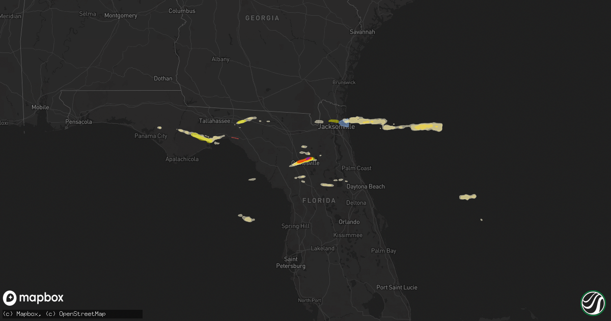
Hail Map on April 11, 2025
Get this storm
April 11 map
$229
one time, instant access
Download today. No call, no setup
Keep the $229
Bought the map and want the full workflow? Apply the entire $229 to a subscription within 7 days. None of it is wasted.
Every map, not just this one
This buys you this map. Subscription and you get every map we run, in the markets you choose from a few cities to whole states to nationwide. Plus real-time alerts the moment a storm fires.
Contact data
Name, contact info, occupancy, even credit band for addresses in the footprint. You go from where it hit to who to call.
Become the source they trust
Unlimited branding weather history reports on demand. You already have the documented answer ready for the property owner, and you are the one who showed up with it.
Property data and RoofTrace estimates
Pull up any address you have got, its value and the exact code rules for that jurisdiction, straight from One Click Code. Then RoofTrace estimates the squares, pitch, and roof value, priced the way you price.
States Impacted by Hail Map on April 11, 2025
Storm reports
Florida
| Date | Description |
|---|---|
| 04/11/20256:00 PM CDT | Public report of up to 2.0 inch diameter hail reported near waldo road/state road 24 and ne 96th ave. |
| 04/11/20255:48 PM CDT | Numerous reports from around gainesville with hail ranging from nickel size to slightly larger than golf balls. |
| 04/11/20255:45 PM CDT | Public report of golf ball size hail falling near the intersection of nw 36th place and nw 47th ter. |
| 04/11/20255:42 PM CDT | Hail slightly bigger than golf ball reported . |
| 04/11/20255:40 PM CDT | Awos station knrb mayport naval station recorded a peak wind gust of 61 mph. |
| 04/11/20255:30 PM CDT | Mesonet station xjak jacksonville reported a peak wind gust of 60 mph. |
| 04/11/20254:07 PM CDT | Member of the public reported approximately quarter size hail near us 98 at 5:07pm edt. |
| 04/11/20253:51 PM CDT | Quarter-size hail reported north of i-10 near greenville... Fl. |
South Carolina
| Date | Description |
|---|---|
| 04/11/20254:00 PM CDT | Sc highway patrol reports two trees down on roadway in florence county |
| 04/11/20254:00 PM CDT | Report of tree down across the road on sardis highway near cusac community in florence county. Media also reports tree fell onto a home in florence county - unknown loc |
North Carolina
| Date | Description |
|---|---|
| 04/10/20257:39 PM CDT | Mping report of quarter size hail in onslow beach. |
| 04/10/20257:25 PM CDT | Multiple reports of hail covering the ground to a depth of a couple of inches in and around sneads ferry. Hail size ranged from dime size to quarter size. Reports relay |
Cities Impacted by Hail Map on April 11, 2025
- Selma, NC
- Pine Level, NC
- Princeton, NC
- Panama City, FL
- Youngstown, FL
- Blountstown, FL
- Bristol, FL
- Greenville, FL
- Madison, FL
- Lamont, FL
- Hosford, FL
- Sopchoppy, FL
- Crawfordville, FL
- Panacea, FL
- Jacksonville, FL
- Lee, FL
- Jasper, FL
- Live Oak, FL
- Sanderson, FL
- Bryceville, FL
- Saint George, GA
- Newberry, FL
- Gainesville, FL
- Archer, FL
- Atlantic Beach, FL
- Neptune Beach, FL
- Hawthorne, FL
- Earleton, FL
- Waldo, FL
- Trenton, FL
- Lake Butler, FL
- Keystone Heights, FL
- Alachua, FL
- Brooker, FL
- Williston, FL
- Reddick, FL
- Holly Ridge, NC
- Sneads Ferry, NC
- Jacksonville, NC
- Morriston, FL
- Ocala, FL
- Hubert, NC
- Silver Springs, FL
- Pierson, FL
- Seville, FL
- Bunnell, FL