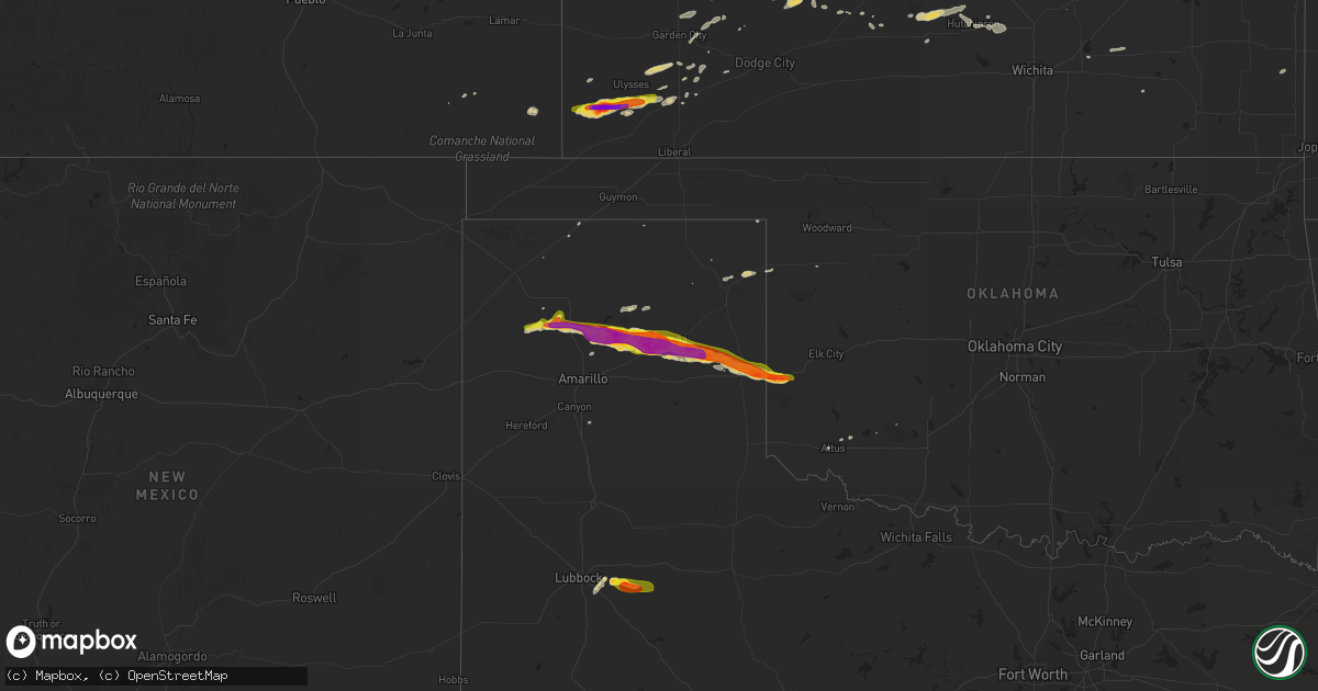
Hail Map on April 11, 2015
Get this storm
April 11 map
$229
one time, instant access
Download today. No call, no setup
Keep the $229
Bought the map and want the full workflow? Apply the entire $229 to a subscription within 7 days. None of it is wasted.
Every map, not just this one
This buys you this map. Subscription and you get every map we run, in the markets you choose from a few cities to whole states to nationwide. Plus real-time alerts the moment a storm fires.
Contact data
Name, contact info, occupancy, even credit band for addresses in the footprint. You go from where it hit to who to call.
Become the source they trust
Unlimited branding weather history reports on demand. You already have the documented answer ready for the property owner, and you are the one who showed up with it.
Property data and RoofTrace estimates
Pull up any address you have got, its value and the exact code rules for that jurisdiction, straight from One Click Code. Then RoofTrace estimates the squares, pitch, and roof value, priced the way you price.
Storm reports
Colorado
| Date | Description |
|---|---|
| 04/11/20155:53 PM CDT | A local report indicates 1.00 inch wind near WALSH |
Texas
| Date | Description |
|---|---|
| 04/11/20156:45 PM CDT | A local report indicates 2.50 inch wind near 8 SSE FRITCH |
| 04/11/20156:10 PM CDT | Penny to quarter size hail. Wall cloud on highway 354 at farm to market road 2202. |
| 04/11/20155:54 PM CDT | Hail covering the road ten to fifteen miles southwest of dumas |
| 04/10/20159:45 PM CDT | A local report indicates 1.75 inch wind near 5 ENE SHAMROCK |
| 04/10/20158:48 PM CDT | A local report indicates 1.75 inch wind near CAPROCK |
| 04/10/20158:45 PM CDT | Branches down |
| 04/10/20158:45 PM CDT | Some branches down |
| 04/10/20158:15 PM CDT | Reported anywhere from pea size to golf ball size and just ended at 845 pm cdt. Could have been damage but have not gone out to check yet. |
| 04/10/20158:13 PM CDT | Reported nickel to quarter size hail |
| 04/10/20158:10 PM CDT | Low correlation coefficient on size distribution. Peas to ping pong balls |
| 04/10/20158:10 PM CDT | A local report indicates 1.75 inch wind near PAMPA |
| 04/10/20158:02 PM CDT | Measured 1.92 inches |
| 04/10/20157:51 PM CDT | Report of golf ball to tennis ball size hail |
| 04/10/20157:48 PM CDT | A local report indicates 1.75 inch wind near BORGER |
| 04/10/20157:45 PM CDT | A local report indicates 1.75 inch wind near WHITE DEER |
| 04/10/20157:42 PM CDT | A local report indicates 1.75 inch wind near WHITE DEER |
| 04/10/20157:40 PM CDT | A local report indicates 1.50 inch wind near SKELLYTOWN |
| 04/10/20157:22 PM CDT | A local report indicates 1.75 inch wind near 5 NW WHITE DEER |
| 04/10/20157:20 PM CDT | Report from twitter |
| 04/10/20157:10 PM CDT | Reported between borger and panhandle |
Oklahoma
| Date | Description |
|---|---|
| 04/10/201510:30 PM CDT | Received report from twitter. |
| 04/10/201510:25 PM CDT | Received report from twitter. |
| 04/10/201510:15 PM CDT | A local report indicates 2.00 inch wind near 3 E TEXOLA |
Kansas
| Date | Description |
|---|---|
| 04/10/201510:10 PM CDT | A lot of pea size hail covering the ground. |
| 04/10/20158:31 PM CDT | A local report indicates 1.25 inch wind near 8 SE BIG BOW |
| 04/10/20158:31 PM CDT | Hail covering the ground. |
| 04/10/20158:24 PM CDT | A local report indicates 1.00 inch wind near 3 SW ULYSSES |
| 04/10/20158:01 PM CDT | A local report indicates 1.75 inch wind near 12 NNE RICHFIELD |
| 04/10/20157:48 PM CDT | A local report indicates 2.75 inch wind near 11 SSW BIG BOW |
| 04/10/20157:40 PM CDT | Dime size hail covered the ground. |
| 04/10/20157:12 PM CDT | A local report indicates 1.00 inch wind near 8 NW RICHFIELD |
Cities Impacted by Hail Map on April 11, 2015
- Canadian, TX
- Panhandle, TX
- Fritch, TX
- Fort Scott, KS
- Johnson, KS
- Richfield, KS
- Higgins, TX
- Lorenzo, TX
- Dighton, KS
- Beeler, KS
- Larned, KS
- Buhler, KS
- Satanta, KS
- Ulysses, KS
- White Deer, TX
- Lakeland, FL
- Channing, TX
- Texola, OK
- Skellytown, TX
- Shamrock, TX
- Groom, TX
- Masterson, TX
- Pampa, TX
- Amarillo, TX
- Erick, OK
- Mclean, TX
- Slaton, TX
- Ralls, TX
- Hanston, KS
- Morland, KS
- Quinter, KS
- Moore Haven, FL
- Moscow, KS
- Elkhart, KS
- Sublette, KS
- Vega, TX
- Mobeetie, TX
- Headrick, OK
- Sylvia, KS
- Sterling, KS
- Altus, OK
- Hutchinson, KS
- Pierceville, KS
- Eureka, KS
- Garden City, KS
- Jetmore, KS
- Laredo, TX
- Nickerson, KS
- Ingalls, KS
- Copeland, KS
- Plainville, KS
- Cimarron, KS
- Kathleen, FL
- Stockton, KS
- Palco, KS
- Hoxie, KS
- Howard, KS
- Burrton, KS
- Halstead, KS
- Hugoton, KS
- Montezuma, KS
- New Smyrna Beach, FL
- Collyer, KS
- St John, KS
- Ness City, KS
- Labelle, FL
- Mirando City, TX
- Canyon, TX
- Happy, TX
- Hill City, KS
- Plevna, KS
- El Dorado, KS
- Borger, TX
- Burdett, KS
- Walsh, CO
- Hudson, KS
- Rozel, KS
- Wakeeney, KS
- Crosbyton, TX
- Wheeler, TX
- Sweetwater, OK
- Sayre, OK