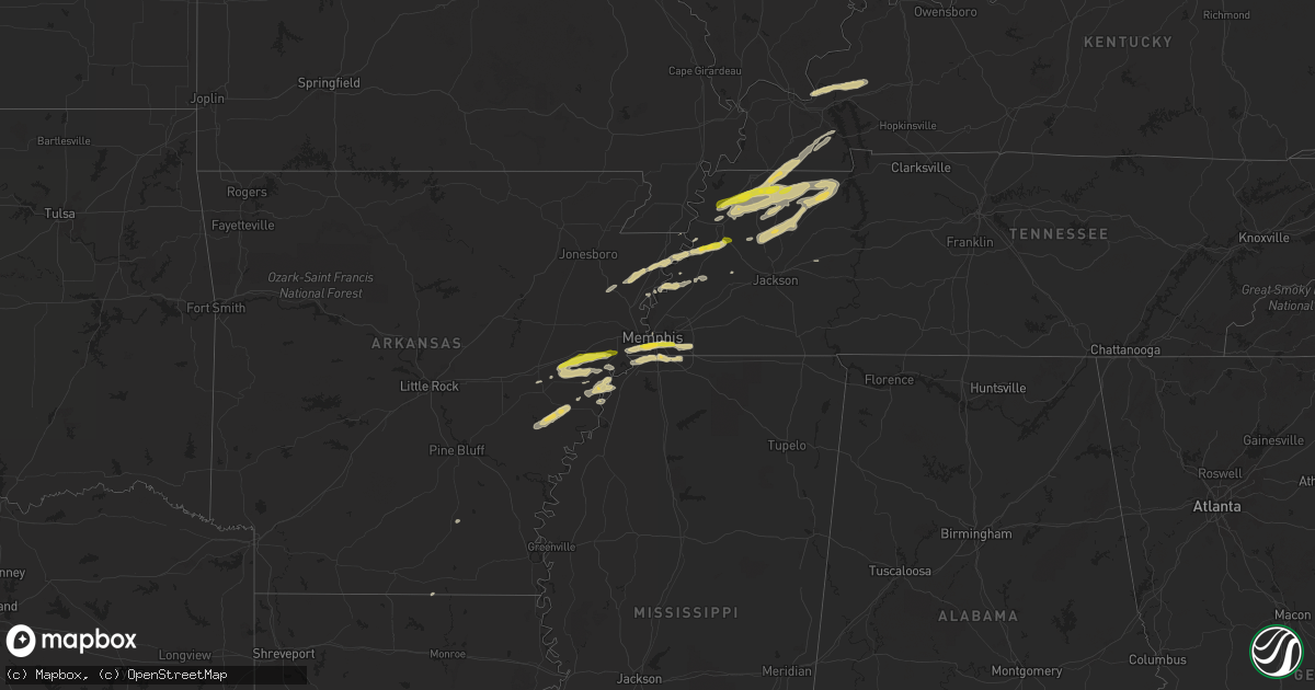
Hail Map on April 7, 2024
Get this storm
April 7 map
$229
one time, instant access
Download today. No call, no setup
Keep the $229
Bought the map and want the full workflow? Apply the entire $229 to a subscription within 7 days. None of it is wasted.
Every map, not just this one
This buys you this map. Subscription and you get every map we run, in the markets you choose from a few cities to whole states to nationwide. Plus real-time alerts the moment a storm fires.
Contact data
Name, contact info, occupancy, even credit band for addresses in the footprint. You go from where it hit to who to call.
Become the source they trust
Unlimited branding weather history reports on demand. You already have the documented answer ready for the property owner, and you are the one who showed up with it.
Property data and RoofTrace estimates
Pull up any address you have got, its value and the exact code rules for that jurisdiction, straight from One Click Code. Then RoofTrace estimates the squares, pitch, and roof value, priced the way you price.
States Impacted by Hail Map on April 7, 2024
Storm reports
Colorado
| Date | Description |
|---|---|
| 04/07/202411:06 AM CDT | Report from mping: 3-inch tree limbs broken; power poles broken. |
Tennessee
| Date | Description |
|---|---|
| 04/07/20246:20 PM CDT | Trees down along needmore road in halls. |
| 04/07/20246:20 PM CDT | Trees down along needmore road east. |
| 04/07/20246:10 PM CDT | A local report indicates 1.00 inch wind near 3 W Halls |
| 04/07/20245:10 PM CDT | A local report indicates 1.00 inch wind near Martin |
| 04/07/20244:59 PM CDT | A local report indicates 63 MPH wind near 4 SW Rives |
| 04/06/20247:41 PM CDT | 60 mph at memphis international airport. |
| 04/06/20247:16 PM CDT | A local report indicates 1.00 inch wind near 2 N Gilt Edge |
Nebraska
| Date | Description |
|---|---|
| 04/07/202412:31 PM CDT | Report from mping: trees uprooted or snapped; roof blown off. |
Kansas
| Date | Description |
|---|---|
| 04/07/20249:55 AM CDT | Off duty nws employee estimates visibility around half a mile to a mile in a plume of blowing dust. |
| 04/07/20249:17 AM CDT | Report from mping: 1-inch tree limbs broken; shingles blown off. |
Illinois
| Date | Description |
|---|---|
| 04/07/20246:23 PM CDT | Time estimate from radar. |
| 04/07/20246:17 PM CDT | Social media report. Time estimated on radar. |
| 04/07/20246:14 PM CDT | Large tree uprooted and fell on to a mobile home. |
| 04/07/20246:04 PM CDT | Report from mping: quarter |
| 04/07/20245:53 PM CDT | Estimated half inch up to one inch hail. Time estimated from radar. |
| 04/07/20245:39 PM CDT | Trees down on hazlet park road. |
| 04/07/20245:21 PM CDT | Major loss of roof panels to a well built farm building. |
| 04/07/20245:08 PM CDT | Corrects previous tstm wnd dmg report from 4 nne carlyle. Trees down on hazlet park road. Time corrected and time is radar estimate. |
| 04/07/20245:08 PM CDT | Wide spread damage to siding and a window is broke. Time estimate from radar. |
| 04/07/20245:08 PM CDT | 3-4 inch tree branches down and food trailer flipped over. Time is radar estimate. |
| 04/07/20244:49 PM CDT | A local report indicates 1.00 inch wind near Aviston |
Iowa
| Date | Description |
|---|---|
| 04/07/20243:51 PM CDT | Video of tornado and damage to barns. |
| 04/07/20243:26 PM CDT | A local report indicates 1.00 inch wind near 2 ESE Eagle Grove |
Cities Impacted by Hail Map on April 7, 2024
- Hubbard, IA
- Iowa Falls, IA
- Obion, TN
- Marked Tree, AR
- Trumann, AR
- Newbern, TN
- Mascoutah, IL
- Trenton, IL
- Troy, TN
- Rives, TN
- Kenton, TN
- Union City, TN
- Aviston, IL
- Germantown, IL
- Breese, IL
- Blytheville, AR
- Dyess, AR
- Lepanto, AR
- Carlyle, IL
- Pocahontas, IL
- Ridgely, TN
- New Baden, IL
- Beckemeyer, IL
- Martin, TN
- Osceola, AR
- Keiser, AR
- Greenville, IL
- Dyersburg, TN
- Keyesport, IL
- Dresden, TN
- Ripley, TN
- Luxora, AR
- Vernon, IL
- Patoka, IL
- Vandalia, IL
- Sandoval, IL
- Odin, IL
- Salem, IL
- Alma, IL
- Trimble, TN
- Bartelso, IL
- Palmersville, TN
- Cottage Grove, TN
- Okawville, IL
- Nashville, IL
- Addieville, IL
- Paris, TN
- Sharon, TN
- Marianna, AR
- Palestine, AR
- Kinmundy, IL
- Saint Peter, IL
- Moro, AR
- Centralia, IL
- Hoffman, IL
- Puryear, TN
- Halls, TN
- Friendship, TN
- Hoyleton, IL
- Forrest City, AR
- Farina, IL
- Clarendon, AR
- Brinkley, AR
- Gates, TN
- Heth, AR
- Highland, IL
- Lebanon, IL
- Widener, AR
- Iuka, IL
- Hughes, AR
- Earle, AR
- Gleason, TN
- Walnut Hill, IL
- Bradford, TN
- Trenton, TN
- Drummonds, TN
- Burlison, TN
- Greenfield, TN
- Milan, TN
- Proctor, AR
- Memphis, TN
- Marion, LA
- Covington, TN
- Trezevant, TN
- Germantown, TN
- Henning, TN
- Smithland, KY
- Walls, MS
- Lake Cormorant, MS
- Tiline, KY
- Brookport, IL
- Grand Rivers, KY
- Brickeys, AR
- Collierville, TN
- Southaven, MS
- Horn Lake, MS
- Marion, KY
- Kell, IL
- Tunica, MS
- Fredonia, KY
- Eddyville, KY
- Princeton, KY
- Salem, KY
- Olive Branch, MS
- South Fulton, TN
- Rutherford, TN
- De Witt, AR
- West Helena, AR
- Dukedom, TN
- Holly Grove, AR
- Marvell, AR
- Water Valley, KY
- Fulton, KY
- Sedalia, KY
- Mayfield, KY
- Wingo, KY
- Poplar Grove, AR
- Lexa, AR
- Murray, KY
- Farmington, KY
- Kirksey, KY
- McKenzie, TN
- Holly Springs, MS
- Red Banks, MS
- Noble, IL
- Hardin, KY
- Benton, KY
- Almo, KY
- Dexter, KY
- Clay City, IL
- Mount Erie, IL
- Atwood, TN
- Humboldt, TN
- Dyer, TN
- Henry, TN
- Buchanan, TN
- Springville, TN
- Wildersville, TN
- Crocketts Bluff, AR
- Tiplersville, MS
- West Memphis, AR
- Marion, AR
- Parkin, AR
- Lexington, TN
- Byhalia, MS
- Michigan City, MS
- Lamar, MS
- Moscow, TN
- Rossville, TN
- Brownsville, TN
- Brighton, TN
- Robinsonville, MS
- Haynes, AR
- Crawfordsville, AR
- Nesbit, MS
- Dundee, MS
- Madison, AR
- Ashland, MS
- Colt, AR
- Courtland, MS
- Water Valley, MS
- Pope, MS
- Oakland, MS