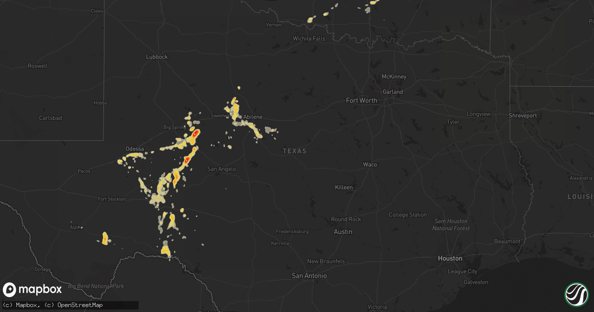
Hail Map on April 7, 2012
Get this storm
April 7 map
$229
one time, instant access
Download today. No call, no setup
Keep the $229
Bought the map and want the full workflow? Apply the entire $229 to a subscription within 7 days. None of it is wasted.
Every map, not just this one
This buys you this map. Subscription and you get every map we run, in the markets you choose from a few cities to whole states to nationwide. Plus real-time alerts the moment a storm fires.
Contact data
Name, contact info, occupancy, even credit band for addresses in the footprint. You go from where it hit to who to call.
Become the source they trust
Unlimited branding weather history reports on demand. You already have the documented answer ready for the property owner, and you are the one who showed up with it.
Property data and RoofTrace estimates
Pull up any address you have got, its value and the exact code rules for that jurisdiction, straight from One Click Code. Then RoofTrace estimates the squares, pitch, and roof value, priced the way you price.
Storm reports
Oklahoma
| Date | Description |
|---|---|
| 04/07/201210:06 AM CDT | Dime to nickel size hail covered entire ground...hailed approximately 20 minutes. |
Texas
| Date | Description |
|---|---|
| 04/07/20126:44 PM CDT | A local report indicates 60 MPH wind near VIEW |
| 04/07/20126:41 PM CDT | Dime to nickel hail continued on the west side of sterling city since 635 pm but has returned to golfball size. |
| 04/07/20126:40 PM CDT | A local report indicates 1.00 inch wind near STERLING CITY |
| 04/07/20126:30 PM CDT | Golfball size hail on west side of town and it began at 627 through 632 pm. |
| 04/07/20126:06 PM CDT | West side of sterling city |
| 04/07/20126:06 PM CDT | West side of sterling city |
| 04/07/20126:03 PM CDT | A local report indicates 1.00 inch wind near 4 SW MERKEL |
| 04/07/20125:57 PM CDT | Report relayed through wfo midland |
| 04/07/20125:18 PM CDT | Pea to quarter sized hail in trent. Relayed through taylor county sheriff office |
| 04/07/20124:54 PM CDT | Fireworks stand and portable shed blown over due to winds estimated at 50 to 55 mph. Dime sized hail also reported. Event time based on radar. |
| 04/07/20124:48 PM CDT | New tornado formed near mitchell/sterling county line. |
| 04/07/20124:48 PM CDT | Tornado on the sterling-mitchell county line. Relayed through wfo midland. |
| 04/07/20124:44 PM CDT | A local report indicates 1.00 inch wind near NOODLE |
| 04/07/20124:38 PM CDT | Trained spotter reported tornado moving south at about 5 mph. |
| 04/07/20124:23 PM CDT | Trained spotter reported tornado on the ground moving southwest at around 5 to 10 mph. |
| 04/07/20124:12 PM CDT | Rotating wall cloud also reported |
| 04/07/20124:03 PM CDT | A local report indicates 2.50 inch wind near 13 S WESTBROOK |
| 04/07/20123:54 PM CDT | A local report indicates 1.50 inch wind near 12 SSE MCCAULLEY |
| 04/07/20123:54 PM CDT | 50 to 60 mph winds |
| 04/07/20123:37 PM CDT | Half dollar sized hail plus estimated winds over 60 mph. |
| 04/07/20123:30 PM CDT | A local report indicates 1.50 inch wind near 5 S NEINDA |
| 04/07/20123:20 PM CDT | A local report indicates 1.75 inch wind near 5 S HAMLIN |
| 04/07/201212:30 AM CDT | Estimated 60 to 70 mph wind gust broke flag pole..shredded flag and wind sock for emergency heli-pad. |
| 04/06/201211:43 PM CDT | Ping pong ball size hail 8 miles south of four corner windmill |
| 04/06/201211:32 PM CDT | Hail up to ping pong size along with very heavy rainfall. |
| 04/06/201211:25 PM CDT | A local report indicates 1.00 inch wind near 1 W OZONA |
| 04/06/201211:15 PM CDT | A local report indicates 1.00 inch wind near SHEFFIELD |
| 04/06/201211:02 PM CDT | Winds esimated 60 to 70 mph |
| 04/06/201211:02 PM CDT | Half dollar to ping pong ball size hail reported along interstate 10. |
| 04/06/201210:25 PM CDT | A local report indicates 1.25 inch wind near 8 S BIG LAKE |
| 04/06/201210:05 PM CDT | A local report indicates 1.50 inch wind near BIG LAKE |
| 04/06/201210:01 PM CDT | Trained spotter also reported tree branches down. |
| 04/06/20129:30 PM CDT | A local report indicates 1.00 inch wind near MCCAMEY |
| 04/06/20129:25 PM CDT | Estimated wind speeds over 60 mph also reported |
| 04/06/20128:10 PM CDT | 15 inch hail drift of pea to quarter size hail size |
| 04/06/20127:44 PM CDT | Tornado was rain wrapped and reported on the ground at 742 pm. |
| 04/06/20127:44 PM CDT | Tornado was rain wrapped and reported on the ground at 742 pm. |
| 04/06/20127:33 PM CDT | A local report indicates 1.00 inch wind near BRONTE |
| 04/06/20127:17 PM CDT | Copious amounts of nickel size hail with some stones as large as quarters. Report relayed through spotter network |
| 04/06/20127:12 PM CDT | Brief rain wrapped tornado reported west of highway 163 |
| 04/06/20127:11 PM CDT | A local report indicates 1.00 inch wind near 2 S SPRABERRY |
| 04/06/20127:08 PM CDT | Pea to quarter size hail reported near tuscola near the intersection of highways 83 and 84. |
Cities Impacted by Hail Map on April 7, 2012
- Sterling City, TX
- Westbrook, TX
- McCamey, TX
- Hennepin, OK
- Zapata, TX
- Baird, TX
- Cross Plains, TX
- Clyde, TX
- Pauls Valley, OK
- Ozona, TX
- Bartlesville, OK
- Pawhuska, OK
- Big Lake, TX
- Midkiff, TX
- Iraan, TX
- Ponca City, OK
- Roff, OK
- Sulphur, OK
- Coleman, TX
- Goldsboro, TX
- Abilene, TX
- Buffalo Gap, TX
- Ovalo, TX
- Tuscola, TX
- Lawn, TX
- Merkel, TX
- Crane, TX
- Robert Lee, TX
- Davis, OK
- Marathon, TX
- Comstock, TX
- Garden City, TX
- Aspermont, TX
- Sylvester, TX
- Coahoma, TX
- Stratford, OK
- Ada, OK
- Dryden, TX
- Wynona, OK
- Odessa, TX
- Newkirk, OK
- Blackwell, TX
- Roby, TX
- Sweetwater, TX
- McCaulley, TX
- Hamlin, TX
- Trent, TX
- Anson, TX
- Nolan, TX
- Colorado City, TX
- Midland, TX
- Bronte, TX
- Duncan, OK
- Barnhart, TX
- Winfield, KS
- Comanche, OK
- Walters, OK
- Ralston, OK
- Fitzhugh, OK
- Wynnewood, OK
- Randlett, OK
- Kaw City, OK
- Big Spring, TX
- Marland, OK
- Devol, OK
- Alpine, TX
- Burkett, TX
- Wellington, KS
- Shidler, OK
- Dexter, KS
- Novice, TX
- Pawnee, OK
- Sheffield, TX
- Fairfax, OK
- Del Rio, TX
- Mertzon, TX
- Burbank, OK
- Arkansas City, KS
- Ira, TX
- Springer, OK