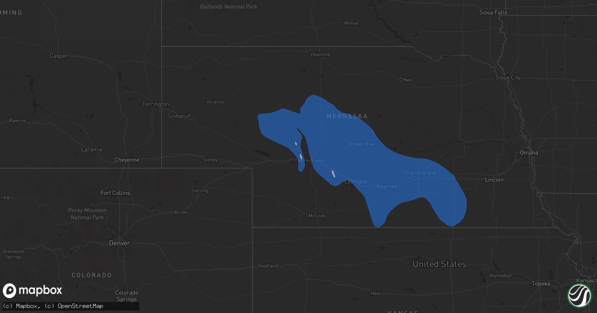
Hail Map on April 6, 2024
Get this storm
April 6 map
$229
one time, instant access
Download today. No call, no setup
Keep the $229
Bought the map and want the full workflow? Apply the entire $229 to a subscription within 7 days. None of it is wasted.
Every map, not just this one
This buys you this map. Subscription and you get every map we run, in the markets you choose from a few cities to whole states to nationwide. Plus real-time alerts the moment a storm fires.
Contact data
Name, contact info, occupancy, even credit band for addresses in the footprint. You go from where it hit to who to call.
Become the source they trust
Unlimited branding weather history reports on demand. You already have the documented answer ready for the property owner, and you are the one who showed up with it.
Property data and RoofTrace estimates
Pull up any address you have got, its value and the exact code rules for that jurisdiction, straight from One Click Code. Then RoofTrace estimates the squares, pitch, and roof value, priced the way you price.
Storm reports
Oklahoma
| Date | Description |
|---|---|
| 04/06/20246:56 PM CDT | Large tree limb down. |
Kansas
| Date | Description |
|---|---|
| 04/06/20245:26 PM CDT | A local report indicates 61 MPH wind near 3 NNW Clay Center |
| 04/06/20245:01 PM CDT | Report from mping: 1-inch tree limbs broken; shingles blown off. |
| 04/06/20244:27 PM CDT | A local report indicates 58 MPH wind near 2 WSW Belleville |
Nebraska
| Date | Description |
|---|---|
| 04/06/20246:10 PM CDT | Est 60mph wind gusts. Large tree limb down on sidewalk. |
| 04/06/20246:10 PM CDT | A local report indicates 64 MPH wind near 4 NNW Ohiowa |
| 04/06/20245:28 PM CDT | Heavy rain causing near 0 visibility. Est wind gusts to around 60mph. (g |
| 04/06/20245:28 PM CDT | Heavy rain causing near 0 visibility. Est wind gusts to around 60mph. |
| 04/06/20245:26 PM CDT | A local report indicates 58 MPH wind near 1 NNW Strang |
| 04/06/20245:19 PM CDT | A local report indicates 59 MPH wind near 8 NE Wolbach |
| 04/06/20245:06 PM CDT | A local report indicates 59 MPH wind near 4 WNW Davenport |
| 04/06/20245:00 PM CDT | Observer said winds were 60 to 70 mph around 5pm. |
| 04/06/20245:00 PM CDT | Est 60-70mph wind gusts with storms. |
| 04/06/20244:59 PM CDT | A local report indicates 59 MPH wind near Grand Island Airport |
| 04/06/20244:53 PM CDT | A local report indicates 58 MPH wind near Grand Island Airport |
| 04/06/20244:50 PM CDT | A local report indicates 61 MPH wind near 2 S Ruskin |
| 04/06/20244:50 PM CDT | A local report indicates 61 MPH wind near 4 ENE Ruskin |
| 04/06/20244:41 PM CDT | A local report indicates 59 MPH wind near 3 WSW Oak |
| 04/06/20244:39 PM CDT | A local report indicates 63 MPH wind near 2 WNW Alda |
| 04/06/20244:35 PM CDT | A local report indicates 60 MPH wind near 3 N Westerville |
| 04/06/20244:34 PM CDT | A local report indicates 66 MPH wind near 5 W Hansen |
| 04/06/20244:34 PM CDT | A local report indicates 66 MPH wind near 5 E Prosser |
| 04/06/20244:31 PM CDT | Wl-callaway12.32sw. |
| 04/06/20244:31 PM CDT | Corrects previous non-tstm wnd gst report from 12 sw callaway. Corrects previous tstm wnd gst report from 12 sw callaway. Corrects previous tstm wnd gst report from 12. |
| 04/06/20244:17 PM CDT | Spotter estimated wind report. |
| 04/06/20244:17 PM CDT | A local report indicates 60 MPH wind near Broken Bow |
| 04/06/20244:15 PM CDT | Corrects previous tstm wnd dmg report from 5 w ogallala. Uprooted tree about 1 foot or larger diamter via social media. |
| 04/06/20244:15 PM CDT | Uprooted tree about 1 foot or larger diamter via social media. |
| 04/06/20244:12 PM CDT | A local report indicates 61 MPH wind near 5 S Anselmo |
| 04/06/20244:05 PM CDT | Measured by davis weather station. Report via fb. |
| 04/06/20244:05 PM CDT | Report via social media with pictures. Damage to roof with shingles lifted up and blown away. |
| 04/06/20244:04 PM CDT | A local report indicates 60 MPH wind near 5 W Huntley |
| 04/06/20244:01 PM CDT | A local report indicates 62 MPH wind near 2 SE Heartwell |
| 04/06/20244:01 PM CDT | A local report indicates 60 MPH wind near 1 W Heartwell |
| 04/06/20244:00 PM CDT | Public report via social media. Estimated 60 mph winds and slushy hail up to dime sized. |
| 04/06/20243:59 PM CDT | A local report indicates 62 MPH wind near 4 N Kearney |
| 04/06/20243:59 PM CDT | A local report indicates 68 MPH wind near 5 NNE Kearney |
| 04/06/20243:54 PM CDT | A local report indicates 63 MPH wind near 1 SSW Sumner |
| 04/06/20243:44 PM CDT | Corrects previous non-tstm wnd gst report from 7 w macon. |
| 04/06/20243:44 PM CDT | A local report indicates 58 MPH wind near Minden |
| 04/06/20243:43 PM CDT | A local report indicates 66 MPH wind near 4 WSW Minden |
| 04/06/20243:40 PM CDT | A local report indicates 64 MPH wind near 8 SW Callaway |
| 04/06/20243:35 PM CDT | A local report indicates 60 MPH wind near 4 NNW Sumner |
| 04/06/20243:31 PM CDT | A local report indicates 59 MPH wind near 8 SW Callaway |
| 04/06/20243:17 PM CDT | A local report indicates 70 MPH wind near 6 NNE Willow Island |
| 04/06/20243:15 PM CDT | A local report indicates 60 MPH wind near 1 NNE Cozad |
| 04/06/20243:13 PM CDT | A local report indicates 58 MPH wind near 7 SSW Overton |
| 04/06/20243:11 PM CDT | A local report indicates 67 MPH wind near Loomis |
| 04/06/20243:08 PM CDT | A local report indicates 65 MPH wind near 3 NNW Alma |
| 04/06/20242:49 PM CDT | A local report indicates 62 MPH wind near 3 ENE North Platte |
| 04/05/20249:19 PM CDT | Measured on personal weather station. |
Cities Impacted by Hail Map on April 6, 2024
- Dickens, NE
- Hershey, NE
- North Platte, NE
- Sutherland, NE
- Maxwell, NE
- Brady, NE
- Moorefield, NE
- Gothenburg, NE
- Tryon, NE
- Farnam, NE
- Cozad, NE
- Willow Island, NE
- Paxton, NE
- Arthur, NE
- Hyannis, NE
- Whitman, NE
- Stapleton, NE
- Mullen, NE
- Callaway, NE
- Arnold, NE
- Lexington, NE
- Oconto, NE
- Elwood, NE
- Smithfield, NE
- Bertrand, NE
- Eddyville, NE
- Loomis, NE
- Oxford, NE
- Atlanta, NE
- Holdrege, NE
- Alma, NE
- Orleans, NE
- Naponee, NE
- Republican City, NE
- Overton, NE
- Sumner, NE
- Wilcox, NE
- Elm Creek, NE
- Funk, NE
- Bloomington, NE
- Hildreth, NE
- Axtell, NE
- Odessa, NE
- Kearney, NE
- Amherst, NE
- Ashby, NE
- Miller, NE
- Minden, NE
- Riverdale, NE
- Seneca, NE
- Broken Bow, NE
- Thedford, NE
- Anselmo, NE
- Merna, NE
- Mason City, NE
- Ansley, NE
- Pleasanton, NE
- Upland, NE
- Gibbon, NE
- Halsey, NE
- Dunning, NE
- Purdum, NE
- Hazard, NE
- Litchfield, NE
- Ravenna, NE
- Wood River, NE
- Shelton, NE
- Kenesaw, NE
- Juniata, NE
- Hastings, NE
- Heartwell, NE
- Roseland, NE
- Holstein, NE
- Doniphan, NE
- Trumbull, NE
- Valentine, NE
- Brewster, NE
- Arcadia, NE
- Westerville, NE
- Comstock, NE
- Loup City, NE
- Rockville, NE
- Cairo, NE
- Grand Island, NE
- Alda, NE
- Giltner, NE
- Johnstown, NE
- Taylor, NE
- Sargent, NE
- Boelus, NE
- Glenvil, NE
- Ayr, NE
- Inland, NE
- Fairfield, NE
- Harvard, NE
- Clay Center, NE
- Edgar, NE
- Nelson, NE
- Oak, NE
- Ruskin, NE
- Byron, NE
- Deshler, NE
- Hardy, NE
- Saronville, NE
- Davenport, NE
- Hebron, NE
- Ong, NE
- Chester, NE
- Hubbell, NE
- Carleton, NE
- Sutton, NE
- Belvidere, NE
- Shickley, NE
- Phillips, NE
- Dannebrog, NE
- Aurora, NE
- Geneva, NE
- Bruning, NE
- Hampton, NE
- Strang, NE
- Henderson, NE
- Grafton, NE
- Chapman, NE
- Marquette, NE
- Ashton, NE
- Saint Paul, NE
- Farwell, NE
- Saint Libory, NE
- Alexandria, NE
- Gilead, NE
- Ohiowa, NE
- Fairmont, NE
- Milligan, NE
- McCool Junction, NE
- York, NE
- Bradshaw, NE
- Archer, NE
- Central City, NE
- Palmer, NE
- Hordville, NE
- Tobias, NE
- Exeter, NE
- Daykin, NE
- Fairbury, NE
- Polk, NE
- Wichita Falls, TX
- Holliday, TX
- Scotland, TX