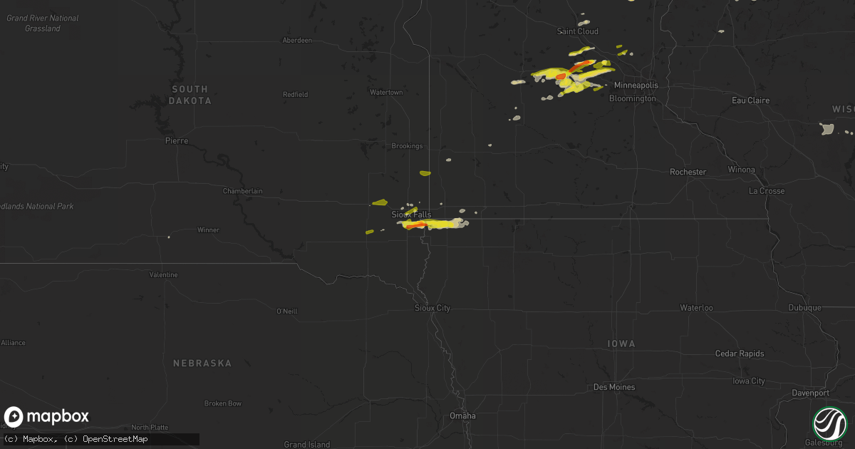
Hail Map on April 5, 2021
Get this storm
April 5 map
$229
one time, instant access
Download today. No call, no setup
Keep the $229
Bought the map and want the full workflow? Apply the entire $229 to a subscription within 7 days. None of it is wasted.
Every map, not just this one
This buys you this map. Subscription and you get every map we run, in the markets you choose from a few cities to whole states to nationwide. Plus real-time alerts the moment a storm fires.
Contact data
Name, contact info, occupancy, even credit band for addresses in the footprint. You go from where it hit to who to call.
Become the source they trust
Unlimited branding weather history reports on demand. You already have the documented answer ready for the property owner, and you are the one who showed up with it.
Property data and RoofTrace estimates
Pull up any address you have got, its value and the exact code rules for that jurisdiction, straight from One Click Code. Then RoofTrace estimates the squares, pitch, and roof value, priced the way you price.
States Impacted by Hail Map on April 5, 2021
Storm reports
Nebraska
| Date | Description |
|---|---|
| 04/05/20217:24 AM CDT | At 1223 AM CDT, outflow associated with weakening showers was located along a line extending from Cedar Bluffs to near Mead to 5 miles northwest of Ashland, moving northeast at 30 mph. HAZARD...60 mph wind gusts. SOURCE...Radar indicated. IMPACT...Expect damage to roofs, siding, and trees. Locations impacted include... Southwestern Omaha, Fremont, Gretna, Valley, Arlington, Yutan, Waterloo, Cedar Bluffs, Mead, Inglewood, Elkhorn, Millard, Bennington, Boys Town, Washington, Memphis, Leshara, Two Rivers State Recreation Area, Chalco and Memphis State Recreation Area. |
| 04/05/20212:06 AM CDT | At 706 PM CDT, a severe thunderstorm was located 9 miles north of Page, or 14 miles east of O'Neill, moving east at 35 mph. HAZARD...60 mph wind gusts. SOURCE...Radar indicated. IMPACT...Expect damage to roofs, siding, and trees. Locations impacted include... Creighton, Verdigre, Winnetoon, Bazile Mills, The Highway 14 And 59 Junction and Ashfall Fossil Beds State Historical Park. |
| 04/05/20212:03 AM CDT | At 703 PM CDT, a severe thunderstorm was located 7 miles northwest of Page, or 8 miles east of O'Neill, moving east at 35 mph. HAZARD...60 mph wind gusts. SOURCE...Radar indicated. IMPACT...Expect damage to roofs, siding, and trees. Locations impacted include... Page and Opportunity. This includes Highway 20 between mile markers 312 and 313. |
| 04/04/20218:28 PM CDT | At 127 AM CDT, outflow associated with weakening showers was located along a line extending from near Kennard to Omaha to 6 miles north of Ralston, moving east at 25 mph. HAZARD...65 mph wind gusts. SOURCE...Radar indicated. IMPACT...Expect damage to roofs, siding, and trees. Locations impacted include... Omaha, Fort Calhoun, Kennard, Carter Lake, Crescent, Desoto Bend National Wildlife Refuge, Wilson Island State Park and Hitchcock Nature Center.This includes Interstate 29 between mile markers 58 and 68. |
| 04/04/20218:07 PM CDT | At 106 AM CDT, outflow associated with weakening showers was located near Arlington, or 25 miles northwest of Omaha, moving northeast at 30 mph. HAZARD...60 mph wind gusts. SOURCE...Radar indicated. IMPACT...Expect damage to roofs, siding, and trees. Locations impacted include... Arlington, Nickerson, Kennard and Washington. |
Iowa
| Date | Description |
|---|---|
| 04/05/20215:07 AM CDT | At 1007 PM CDT, a severe thunderstorm was located over Rock Rapids, moving east at 35 mph. HAZARD...60 mph wind gusts and half dollar size hail. SOURCE...Radar indicated. IMPACT...Hail damage to vehicles is expected. Expect wind damage to roofs, siding, and trees. This severe thunderstorm will be near... Ellsworth around 1015 PM CDT. George around 1020 PM CDT. Little Rock around 1030 PM CDT. Sibley and Ashton around 1040 PM CDT. Melvin around 1055 PM CDT.Other locations impacted by this severe thunderstorm include Bigelowand Steen. |
| 04/05/20214:27 AM CDT | At 927 PM CDT, a severe thunderstorm was located over Lake Alvin State Recreation Area, or 7 miles southeast of Sioux Falls, moving northeast at 30 mph. HAZARD...Quarter size hail. SOURCE...Public. At 920 PM, there were two reports of quarter sized hail on the south side of Sioux Falls, near 85th St. and Louise Ave. IMPACT...Damage to vehicles is expected. This severe thunderstorm will be near... Rowena around 940 PM CDT. Larchwood around 945 PM CDT. Valley Springs around 950 PM CDT. |
| 04/05/20214:04 AM CDT | At 904 PM CDT, a severe thunderstorm was located near Tea, or 10 miles southwest of Sioux Falls, moving northeast at 30 mph. HAZARD...Quarter size hail. SOURCE...Radar indicated. IMPACT...Damage to vehicles is expected. This severe thunderstorm will be near... Tea around 910 PM CDT. Harrisburg around 925 PM CDT. Sioux Falls and Lake Alvin State Recreation Area around 930 PM CDT. |
| 04/04/202110:02 PM CDT | A local report indicates 1.25 inch wind near 1 SSW ROCK RAPIDS |
| 04/04/20219:44 PM CDT | Report via mping. |
| 04/04/20219:40 PM CDT | Report received via social media. |
Minnesota
| Date | Description |
|---|---|
| 04/05/20215:59 AM CDT | At 1059 PM CDT, a severe thunderstorm was located near Buffalo, moving east at 40 mph. HAZARD...60 mph wind gusts and quarter size hail. SOURCE...Radar indicated. IMPACT...Hail damage to vehicles is expected. Expect wind damage to roofs, siding, and trees. This severe thunderstorm will be near... Rockford around 1105 PM CDT. Independence around 1110 PM CDT. Albertville and Corcoran around 1120 PM CDT. Maple Grove, St. Michael, Otsego and Rogers around 1125 PM CDT. Brooklyn Park, Ramsey, Champlin and Anoka around 1135 PM CDT. Coon Rapids and Andover around 1140 PM CDT. Blaine around 1145 PM CDT.Other locations impacted by this severe thunderstorm include Nowthen,Hanover, Greenfield, Buffalo Airport, Osseo, Dayton and Oak Grove. |
| 04/05/20215:27 AM CDT | At 1027 PM CDT, a severe thunderstorm was located over Winsted, or 17 miles southwest of Buffalo, moving east at 50 mph. Quarter sized hail was reported in Silver Lake at 10:25 PM. HAZARD...60 mph wind gusts and quarter size hail. SOURCE...Radar indicated. IMPACT...Hail damage to vehicles is expected. Expect wind damage to roofs, siding, and trees. This severe thunderstorm will be near... Watertown, Montrose and Mayer around 1035 PM CDT. Delano around 1040 PM CDT. Rockford and St. Bonifacius around 1045 PM CDT. Chanhassen, Mound, Orono, Victoria and Minnetrista around 1050 PM CDT. Wayzata and Excelsior around 1055 PM CDT.Other locations impacted by this severe thunderstorm include Loretto,Hollywood, Greenwood, Shorewood, Lake Waconia, Long Lake, NewGermany, Hamel, Deephaven and Greenfield. |
| 04/05/20215:10 AM CDT | At 1010 PM CDT, a severe thunderstorm was located over Quamba, or 13 miles west of Hinckley, moving east at 30 mph. HAZARD...Golf ball size hail and 60 mph wind gusts. Golf ball size hail was reported north of Mora. SOURCE...Trained weather spotters. IMPACT...People and animals outdoors will be injured. Expect hail damage to roofs, siding, windows, and vehicles. Expect wind damage to roofs, siding, and trees. This severe thunderstorm will remain over mainly rural areas of central Kanabec County, including the following locations... Knife Lake and Mora Airport. |
| 04/05/20214:54 AM CDT | At 954 PM CDT, a severe thunderstorm was located near Dassel, or 9 miles northeast of Hutchinson, moving east at 35 mph. HAZARD...60 mph wind gusts and quarter size hail. SOURCE...Radar indicated. IMPACT...Hail damage to vehicles is expected. Expect wind damage to roofs, siding, and trees. This severe thunderstorm will be near... Cokato around 1005 PM CDT. Winsted and Howard Lake around 1015 PM CDT. Montrose around 1025 PM CDT. Watertown around 1030 PM CDT.Other locations impacted by this severe thunderstorm include Waverly. |
| 04/05/20214:48 AM CDT | At 948 PM CDT, a severe thunderstorm was located near Foley, or 9 miles northeast of St. Cloud, moving east at 30 mph. HAZARD...60 mph wind gusts and quarter size hail. SOURCE...Radar indicated. IMPACT...Hail damage to vehicles is expected. Expect wind damage to roofs, siding, and trees. This severe thunderstorm will be near... Foley around 1000 PM CDT. Foreston around 1020 PM CDT. Milaca around 1025 PM CDT. Princeton around 1030 PM CDT.Other locations impacted by this severe thunderstorm include Mayhew,Glendorado, Parent, Ronneby, Pease, Oak Park, Princeton Airport andGilman. |
| 04/05/20214:45 AM CDT | At 944 PM CDT, a severe thunderstorm was located over Litchfield, or 18 miles north of Hutchinson, moving east at 35 mph. HAZARD...60 mph wind gusts and quarter size hail. SOURCE...Radar indicated. IMPACT...Hail damage to vehicles is expected. Expect wind damage to roofs, siding, and trees. This severe thunderstorm will be near... Dassel around 1000 PM CDT. Cokato around 1010 PM CDT. Annandale around 1020 PM CDT. Maple Lake around 1030 PM CDT.Other locations impacted by this severe thunderstorm include Darwin,French Lake, Litchfield Airport, Rassat, Forest City, Smith Lake andWaverly. |
| 04/05/20214:20 AM CDT | At 919 PM CDT, a severe thunderstorm was located over Grove City, or 15 miles east of Willmar, moving east at 40 mph. HAZARD...60 mph wind gusts and quarter size hail. SOURCE...Radar indicated. IMPACT...Hail damage to vehicles is expected. Expect wind damage to roofs, siding, and trees. This severe thunderstorm will be near... Litchfield around 935 PM CDT. Dassel around 945 PM CDT.Other locations impacted by this severe thunderstorm include ForestCity, Litchfield Airport and Darwin. |
| 04/05/20214:16 AM CDT | At 916 PM CDT, a severe thunderstorm was located over Clearwater, or 15 miles northwest of Buffalo, moving east at 50 mph. Trained Weather Spotters reported 1 inch hail in Fairhaven. HAZARD...60 mph wind gusts and quarter size hail. SOURCE...Trained weather spotters. IMPACT...Hail damage to vehicles is expected. Expect wind damage to roofs, siding, and trees. This severe thunderstorm will be near... Clear Lake around 920 PM CDT. Monticello and Becker around 925 PM CDT. Big Lake around 935 PM CDT. Elk River and Zimmerman around 940 PM CDT. Princeton around 945 PM CDT.Other locations impacted by this severe thunderstorm includeSherburne National Wildlife Refuge, Enfield, Orrock, Hasty and SilverCreek. |
| 04/05/20213:44 AM CDT | At 844 PM CDT, a severe thunderstorm was located over Sioux Falls, moving northeast at 35 mph. HAZARD...Quarter size hail. SOURCE...Radar indicated. IMPACT...Damage to vehicles is expected. This severe thunderstorm will be near... Rowena around 855 PM CDT. Brandon around 900 PM CDT. Palisades State Park around 905 PM CDT. Garretson and Valley Springs around 910 PM CDT. Sherman around 915 PM CDT. |
| 04/05/20213:26 AM CDT | At 826 PM CDT, a severe thunderstorm was located over Albertville, or 11 miles east of Buffalo, moving northeast at 30 mph. HAZARD...60 mph wind gusts and quarter size hail. SOURCE...Radar indicated. IMPACT...Hail damage to vehicles is expected. Expect wind damage to roofs, siding, and trees. This severe thunderstorm will be near... Otsego around 835 PM CDT. Ramsey and St. Francis around 845 PM CDT. Andover and Anoka around 850 PM CDT. Ham Lake around 900 PM CDT. East Bethel around 915 PM CDT.Other locations impacted by this severe thunderstorm include Nowthen,Oak Grove, Bethel and Cedar. |
| 04/05/20212:40 AM CDT | At 740 PM CDT, a severe thunderstorm was located near Dassel, or 17 miles north of Hutchinson, moving northeast at 35 mph. HAZARD...60 mph wind gusts and quarter size hail. SOURCE...Radar indicated. IMPACT...Hail damage to vehicles is expected. Expect wind damage to roofs, siding, and trees. This severe thunderstorm will be near... Annandale around 755 PM CDT. Maple Lake around 805 PM CDT. Buffalo around 810 PM CDT. Monticello around 820 PM CDT. Albertville around 830 PM CDT.Other locations impacted by this severe thunderstorm include Enfield,Buffalo Airport, Silver Creek, French Lake, Rassat, Hasty and SmithLake. |
| 04/05/20212:39 AM CDT | At 739 PM CDT, a severe thunderstorm was located near Trent, or 12 miles west of Pipestone, moving east at 30 mph. HAZARD...60 mph wind gusts and quarter size hail. SOURCE...Radar indicated. IMPACT...Hail damage to vehicles is expected. Expect wind damage to roofs, siding, and trees. This severe thunderstorm will be near... Jasper around 750 PM CDT. Pipestone and Pipestone National Monument around 805 PM CDT. Trosky around 810 PM CDT.Other locations impacted by this severe thunderstorm include Ihlen. |
| 04/05/20212:04 AM CDT | A 64mph wind gust... Brought repeater antennas down... And lifted play set out of the ground. |
| 04/05/20212:00 AM CDT | Downed fence... From video reported on steele county skywarn facebook group. |
| 04/05/20212:00 AM CDT | Large pine tree snapped near the base... Photo from skywarn group on facebook. |
| 04/05/20212:00 AM CDT | Trampoline vaulted over 12ft. Hedges to get next to the road... Tall pine tree fell down... And a steel patio pergola completely collapsed. |
| 04/05/20211:55 AM CDT | Roof blown off shed. Empty grain bin blown over. |
| 04/04/202111:45 PM CDT | Social media report with image. |
| 04/04/202111:30 PM CDT | 1 hail covering the ground. |
| 04/04/202111:25 PM CDT | A local report indicates 1.00 inch wind near CORCORAN |
| 04/04/202111:23 PM CDT | Phoned in report. |
| 04/04/202111:19 PM CDT | A local report indicates 1.00 inch wind near 3 WSW HANOVER |
| 04/04/202111:19 PM CDT | A local report indicates 1.00 inch wind near 1 W HANOVER |
| 04/04/202111:01 PM CDT | A local report indicates 1.00 inch wind near ROCKFORD |
| 04/04/202110:30 PM CDT | A local report indicates 1.00 inch wind near WINSTED |
| 04/04/202110:27 PM CDT | A local report indicates 1.00 inch wind near 5 NNE SILVER LAKE |
| 04/04/202110:14 PM CDT | Phoned in report. |
| 04/04/202110:14 PM CDT | A local report indicates 1.00 inch wind near HUTCHINSON |
| 04/04/202110:07 PM CDT | Phoned in report. |
| 04/04/202110:05 PM CDT | Phoned in report. |
| 04/04/20219:53 PM CDT | Phoned in report. |
| 04/04/20219:30 PM CDT | 4 large |
| 04/04/20219:14 PM CDT | Phoned in report of quarter to marble sized hail. |
| 04/04/20218:34 PM CDT | 1 inch hail reported near crown mn. |
| 04/04/20218:11 PM CDT | Trained spotter reports golf ball hail cty 5 and cty 37 in maple lake at 2011 utc. |
| 04/04/20218:00 PM CDT | Tweet with photo from off duty nws meteorologist. |
South Dakota
| Date | Description |
|---|---|
| 04/05/20214:48 AM CDT | At 947 PM CDT, a severe thunderstorm was located over Larchwood, or 11 miles west of Rock Rapids, moving east at 25 mph. HAZARD...60 mph wind gusts and half dollar size hail. SOURCE...Radar indicated. IMPACT...Hail damage to vehicles is expected. Expect wind damage to roofs, siding, and trees. This severe thunderstorm will be near... Rock Rapids around 1005 PM CDT.Other locations impacted by this severe thunderstorm include Steen. |
| 04/05/20212:49 AM CDT | At 749 PM CDT, a severe thunderstorm was located near Freeman, or 11 miles west of Parker, moving east at 30 mph. HAZARD...60 mph wind gusts and quarter size hail. SOURCE...Radar indicated. IMPACT...Hail damage to vehicles is expected. Expect wind damage to roofs, siding, and trees. This severe thunderstorm will be near... Marion around 800 PM CDT. Monroe around 810 PM CDT. Parker around 815 PM CDT. |
| 04/05/20212:03 AM CDT | At 703 PM CDT, a severe thunderstorm was located near Montrose, or near Lake Vermillion State Recreation Area, moving east at 25 mph. HAZARD...60 mph wind gusts and quarter size hail. SOURCE...Radar indicated. IMPACT...Hail damage to vehicles is expected. Expect wind damage to roofs, siding, and trees. This severe thunderstorm will be near... Lake Vermillion State Recreation Area and Montrose around 710 PM CDT. Humboldt around 725 PM CDT. |
| 04/04/20219:27 PM CDT | Lake alvin area. Reported via social media. |
| 04/04/20219:25 PM CDT | A local report indicates 1.25 inch wind near 3 E HARRISBURG |
| 04/04/20219:21 PM CDT | A local report indicates 1.00 inch wind near 1 NNE HARRISBURG |
| 04/04/20219:20 PM CDT | Report received via mping. |
| 04/04/20219:20 PM CDT | Report received via social media. |
| 04/04/20219:13 PM CDT | Reported via mping. |
| 04/04/20218:44 PM CDT | Hail still falling. |
| 04/04/20218:43 PM CDT | Corrects previous hail report from 3 n sioux falls. Hail still falling. |
| 04/04/20217:50 PM CDT | A local report indicates 1.00 inch wind near 4 E FREEMAN |
| 04/04/20217:45 PM CDT | A local report indicates 1.00 inch wind near 7 E FLANDREAU |
Wisconsin
| Date | Description |
|---|---|
| 04/04/202110:00 PM CDT | Photo relayed from nws duluth. |
Cities Impacted by Hail Map on April 5, 2021
- Cloquet, MN
- Esko, MN
- Carlton, MN
- Duluth, MN
- Waverly, MN
- Mayer, MN
- Howard Lake, MN
- Montrose, MN
- Raymond, MN
- Blomkest, MN
- Willmar, MN
- Hinckley, MN
- Brook Park, MN
- Saginaw, MN
- Rock Rapids, IA
- Silver Lake, MN
- Winsted, MN
- Hutchinson, MN
- Cokato, MN
- Wahkon, MN
- Mora, MN
- Isle, MN
- Hurley, WI
- Saxon, WI
- Ironwood, MI
- Luverne, MN
- Sioux Falls, SD
- Pittsville, WI
- Buffalo, MN
- Barnum, MN
- Larchwood, IA
- Minong, WI
- Hayward, WI
- Glidden, WI
- Foley, MN
- Sauk Rapids, MN
- Tomahawk, WI
- Irma, WI
- Gleason, WI
- Deerbrook, WI
- Annandale, MN
- Cold Spring, MN
- Saint Michael, MN
- South Haven, MN
- Kimball, MN
- Dassel, MN
- Litchfield, MN
- Darwin, MN
- Atwater, MN
- Grove City, MN
- Canton, SD
- Harrisburg, SD
- Lennox, SD
- Tea, SD
- Worthing, SD
- Sandstone, MN
- Plover, WI
- Moose Lake, MN
- Adrian, MN
- Redwood Falls, MN
- Monticello, MN
- Becker, MN
- Maple Lake, MN
- Clearwater, MN
- Maple Plain, MN
- Walnut Grove, MN
- Wisconsin Rapids, WI
- Lester, IA
- Alvord, IA
- Little Rock, IA
- George, IA
- Danbury, WI
- Springbrook, WI
- Ellsworth, MN
- Granton, WI
- Chili, WI
- Marshfield, WI
- Olivia, MN
- Parker, SD
- Cumberland, WI
- Holland, MN
- Ruthton, MN
- Brookston, MN
- Vesper, WI
- Inwood, IA
- Rice, MN
- Renville, MN
- Danube, MN
- Buffalo Lake, MN
- Hector, MN
- Delano, MN
- Stone Lake, WI
- Sibley, IA
- Hartford, SD
- Onamia, MN
- Rockford, MN
- Lester Prairie, MN
- Loretto, MN
- Rushmore, MN
- Bancroft, WI
- Anoka, MN
- Watertown, MN
- Crooks, SD
- Renner, SD
- Lake Lillian, MN
- Finlayson, MN
- Cedar, MN
- Albertville, MN
- Zimmerman, MN
- Elk River, MN
- New Germany, MN
- Hanover, MN
- Rogers, MN
- Hamel, MN
- Montrose, SD
- Canistota, SD
- Humboldt, SD
- Salem, SD
- Flandreau, SD
- Pipestone, MN
- Marion, SD
- Freeman, SD
- Brandon, SD