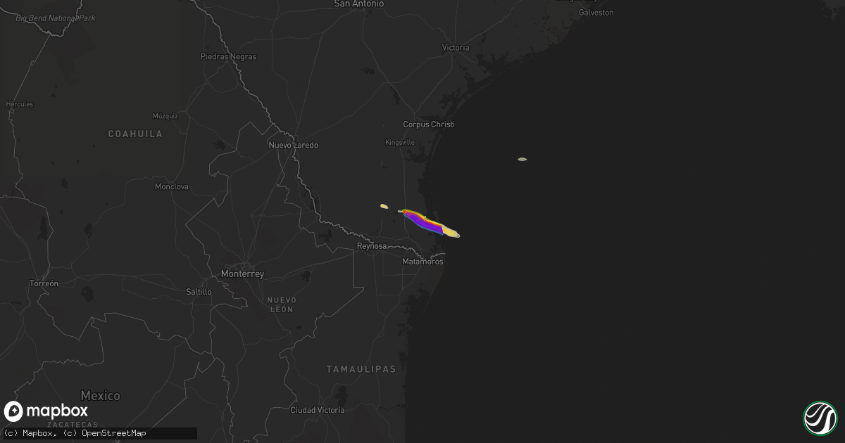
Hail Map on April 4, 2020
Get this storm
April 4 map
$229
one time, instant access
Download today. No call, no setup
Keep the $229
Bought the map and want the full workflow? Apply the entire $229 to a subscription within 7 days. None of it is wasted.
Every map, not just this one
This buys you this map. Subscription and you get every map we run, in the markets you choose from a few cities to whole states to nationwide. Plus real-time alerts the moment a storm fires.
Contact data
Name, contact info, occupancy, even credit band for addresses in the footprint. You go from where it hit to who to call.
Become the source they trust
Unlimited branding weather history reports on demand. You already have the documented answer ready for the property owner, and you are the one who showed up with it.
Property data and RoofTrace estimates
Pull up any address you have got, its value and the exact code rules for that jurisdiction, straight from One Click Code. Then RoofTrace estimates the squares, pitch, and roof value, priced the way you price.
States Impacted by Hail Map on April 4, 2020
Storm reports
Texas
| Date | Description |
|---|---|
| 04/04/20209:23 AM CDT | Social media reported of estimated two inch hail in arroyo city. |
| 04/04/20208:44 AM CDT | Social media reported estimated golf ball sized hail in santa monica. |
| 04/04/20208:21 AM CDT | A mobile home destroyed in san perlita. |
| 04/04/20208:21 AM CDT | Willacy county sheriff reported numerous power poles down along hwy 186. |
| 04/04/20208:21 AM CDT | Willacy county sheriff reported numerous power poles down two miles north of san perlita on fm 2209 and multiple power lines down along hwy 3142 east of san perlita. |
| 04/04/20208:16 AM CDT | A power pole down on us hwy 77 and sauz ave. |
| 04/04/20205:01 AM CDT | At 959 AM CDT, a severe thunderstorm was located 10 miles north of South Padre Island, moving southeast at 25 mph. This is a very dangerous storm. HAZARD...Three inch hail and 70 mph wind gusts. SOURCE...Emergency management. IMPACT...People and animals outdoors will be severely injured. Expect shattered windows, extensive damage to roofs, siding, and vehicles. Locations impacted include... South Padre Island, South Padre Island Convention Center, Beach Access Five, Beach Access Four, South Padre Island Birding Center and Port Isabel--Laguna Heights. |
| 04/04/20204:12 AM CDT | At 911 AM CDT, a severe thunderstorm was located over Jose Borrego Middle School, or near Arroyo City, moving southeast at 25 mph. This is a very dangerous storm. HAZARD...Three inch hail and 70 mph wind gusts. SOURCE...Radar indicated. IMPACT...People and animals outdoors will be severely injured. Expect shattered windows, extensive damage to roofs, siding, and vehicles. Locations impacted include... South Padre Island, Arroyo City, Port Isabel Lighthouse, South Padre Island Convention Center, Pharr Central Fire Station, South Padre Island Birding Center, U.s. Coast Guard Station, South Padre Island Police Department, Port Isabel City Hall and Port Isabel--Laguna Heights. |
| 04/04/20203:31 AM CDT | At 830 AM CDT, a severe thunderstorm was located over San Perlita High School, or 8 miles east of Raymondville, moving southeast at 30 mph. HAZARD...Two inch hail and 60 mph wind gusts. SOURCE...Radar indicated. IMPACT...People and animals outdoors will be injured. Expect hail damage to roofs, siding, windows, and vehicles. Expect wind damage to roofs, siding, and trees. Locations impacted include... Arroyo City, Port Mansfield, San Perlita, Willamar, Santa Monica, Port Mansfield Chamber Of Commerce, San Perlita High School, Port Mansfield Airport, Porfirio and Los Coyotes. |
| 04/04/20203:15 AM CDT | At 815 AM CDT, a severe thunderstorm was located near Raymondville, moving southeast at 30 mph. HAZARD...Ping pong ball size hail and 60 mph wind gusts. SOURCE...Radar indicated. IMPACT...People and animals outdoors will be injured. Expect hail damage to roofs, siding, windows, and vehicles. Expect wind damage to roofs, siding, and trees. Locations impacted include... Raymondville, Arroyo City, Port Mansfield, San Perlita, Port Mansfield Chamber Of Commerce, Reber Memorial Library, Port Mansfield Airport, Porfirio, Raymondville High School and Raymondville Police Department.This includes the following highways... Interstate Highway 69 E between mile markers 45 and 51. US Highway 77 between mile markers 758 and 762. |
| 04/04/20202:12 AM CDT | At 711 AM CDT, a severe thunderstorm was located near San Manuel, moving southeast at 30 mph. HAZARD...Two inch hail and 60 mph wind gusts. SOURCE...Radar indicated. IMPACT...People and animals outdoors will be injured. Expect hail damage to roofs, siding, windows, and vehicles. Expect wind damage to roofs, siding, and trees. Locations impacted include... Raymondville, La Villa, Hargill, Lasara, San Manuel, Linn, Reber Memorial Library, Red Gate, La Villa High School and Yturria.This includes the following highways... Interstate Highway 69 E between mile markers 50 and 51. US Highway 77 between mile markers 754 and 762. US Highway 281 between mile markers 748 and 764. |
| 04/04/20201:26 AM CDT | At 625 AM CDT, a severe thunderstorm was located near San Isidro, or 16 miles southwest of Rachal, moving southeast at 30 mph. HAZARD...Tennis ball size hail and 60 mph wind gusts. SOURCE...Radar indicated. IMPACT...People and animals outdoors will be injured. Expect hail damage to roofs, siding, windows, and vehicles. Expect wind damage to roofs, siding, and trees. Locations impacted include... Linn, San Manuel, Puerto Rico, La Reforma, San Isidro and Red Gate.This includes US Highway 281 between mile markers 740 and 762. |
| 04/04/20201:08 AM CDT | At 607 AM CDT, a severe thunderstorm was located over San Rafael Ranch Airport, or 7 miles southeast of Agua Nueva, moving east at 20 mph. HAZARD...Two inch hail and 60 mph wind gusts. SOURCE...Radar indicated. IMPACT...People and animals outdoors will be injured. Expect hail damage to roofs, siding, windows, and vehicles. Expect wind damage to roofs, siding, and trees. Locations impacted include... La Reforma, San Isidro, San Rafael Ranch Airport, Santa Elena and Puesta Del Sol Airport. |
| 04/03/20208:54 PM CDT | At 153 AM CDT, a severe thunderstorm was located 15 miles northeast of Bruni, or 18 miles west of Benavides, moving northeast at 40 mph. HAZARD...Quarter size hail. SOURCE...Radar indicated. IMPACT...Damage to vehicles is expected. Locations impacted include... San Diego and Rosita. |