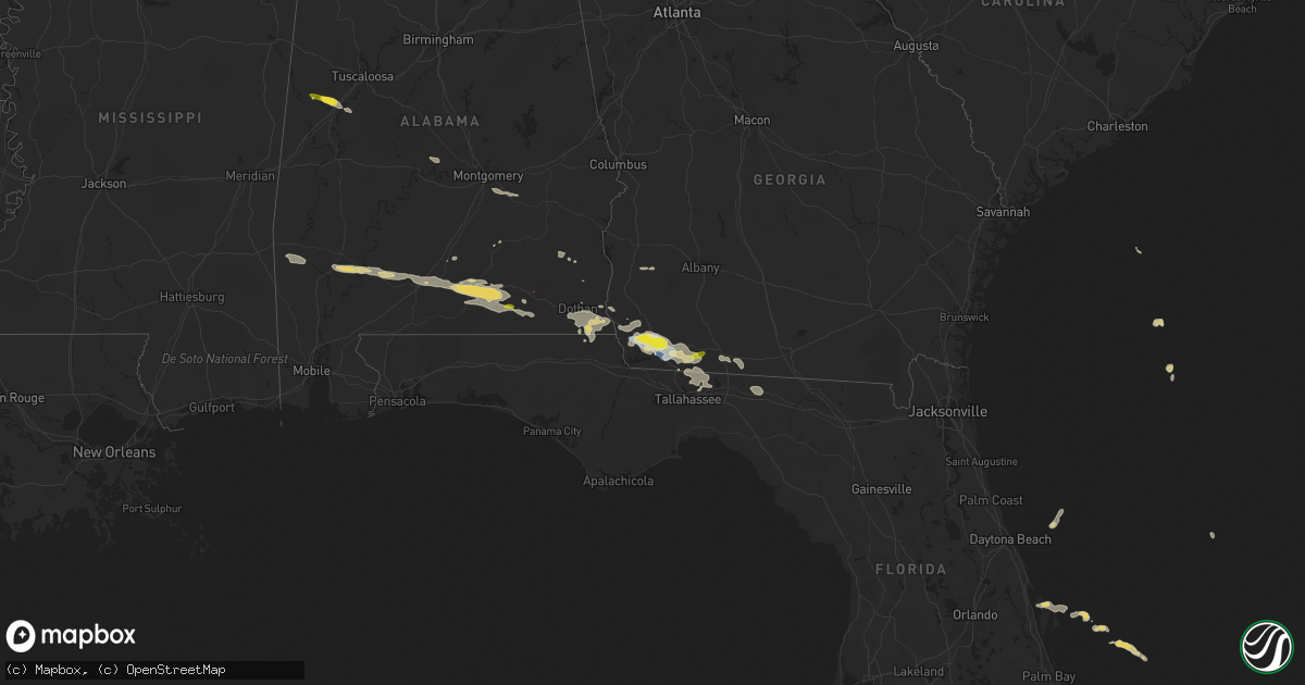
Hail Map on April 3, 2023
Get this storm
April 3 map
$229
one time, instant access
Download today. No call, no setup
Keep the $229
Bought the map and want the full workflow? Apply the entire $229 to a subscription within 7 days. None of it is wasted.
Every map, not just this one
This buys you this map. Subscription and you get every map we run, in the markets you choose from a few cities to whole states to nationwide. Plus real-time alerts the moment a storm fires.
Contact data
Name, contact info, occupancy, even credit band for addresses in the footprint. You go from where it hit to who to call.
Become the source they trust
Unlimited branding weather history reports on demand. You already have the documented answer ready for the property owner, and you are the one who showed up with it.
Property data and RoofTrace estimates
Pull up any address you have got, its value and the exact code rules for that jurisdiction, straight from One Click Code. Then RoofTrace estimates the squares, pitch, and roof value, priced the way you price.
Storm reports
Georgia
| Date | Description |
|---|---|
| 04/03/202312:59 PM CDT | Grady county fire department reported golf ball sized hail south of whigham. |
| 04/03/202312:49 PM CDT | Nws employee reports several trees down near us-84 over a 1 mile stretch. |
| 04/03/202312:48 PM CDT | Ef1 tornado confirmed by storm survey. |
| 04/03/202312:48 PM CDT | Ef1 tornado confirmed by storm survey. |
| 04/03/202312:45 PM CDT | Tree down at 141 nebo church road. |
| 04/03/202312:40 PM CDT | Ef1 tornado confirmed by storm survey. |
| 04/03/202312:40 PM CDT | Ef1 tornado confirmed by storm survey. |
| 04/03/202312:39 PM CDT | Tree down on a house on boxwood drive. |
| 04/03/202312:31 PM CDT | Multiple reports west of bainbridge of hail falling. Sizes ranged from pea to quarter size. |
| 04/03/202312:30 PM CDT | Mesonet station tt665 bainbridge. |
| 04/03/202312:30 PM CDT | Bainbridge airport reported wind gust of 64 mph or 56 knots. |
| 04/03/202312:30 PM CDT | Several trees and powerlines down west of bainbridge. In the industrial park two shops had doors blown in. |
| 04/03/202312:27 PM CDT | Nws employee relayed photo of downed tree blocking highway 253 sw of bainbridge. Also some minor roof damage to a structure in the area. |
| 04/03/202312:21 PM CDT | Powerlines down at donahoo dr and park ave. |
Florida
| Date | Description |
|---|---|
| 04/03/20233:50 PM CDT | Tree down near se county rd 135/third st. Time estimated from radar. |
| 04/03/20233:47 PM CDT | Tree down near se county rd 137 and highway 41. Time estimated from radar. |
| 04/03/20233:47 PM CDT | Tree down on se 99th way. Time estimated from radar. |
| 04/03/20233:44 PM CDT | Tree down near se county rd 25a and se 137th blvd. Time estimated from radar. |
| 04/03/20233:38 PM CDT | Tree down near se county rd 137 and 50th dr. Time estimated by radar. |
| 04/03/20233:00 PM CDT | Powerline down on summerstet way. Time estimated by radar. |
| 04/03/20232:30 PM CDT | Tree partially blocking i-10 eastbound at mile marker 230. Time estimated by radar. |
| 04/03/20231:35 PM CDT | Powerline down on bethpage road. Time estimated by radar. |
| 04/03/20231:21 PM CDT | A couple trees down near the intersection of fairbanks ferry road and concord road. Time estimated by radar. |
Alabama
| Date | Description |
|---|---|
| 04/03/202311:19 AM CDT | Trees down in westgate park. Power outages also reported. Time estimated by radar. |
| 04/03/202311:19 AM CDT | Tree down on a home on whatley drive. Time estimated by radar. |
| 04/03/202311:17 AM CDT | Tree down on hillstone dr. |
| 04/03/202311:17 AM CDT | A few trees down in taylor. |
| 04/03/202311:16 AM CDT | Tree down on baker tr. |
| 04/03/202311:15 AM CDT | Storm debris was on highway 167 in both directions near mp 14 before county road 41. |
| 04/03/202311:14 AM CDT | Tree down on el dorado st. |
| 04/03/202311:14 AM CDT | Tree down on buena vista dr. |
| 04/03/202311:14 AM CDT | Video of a brief tornado on appian way. |
| 04/03/202311:14 AM CDT | Tree down on englewood dr. |
| 04/03/202311:11 AM CDT | Tree down on a house on whatley dr. |
| 04/03/202311:09 AM CDT | Tree down on trawick rd. |
| 04/03/202310:33 AM CDT | Brief spin-up tornado near highway 167 and shellfield road. |
| 04/03/202310:25 AM CDT | Tree down near new home church. |
| 04/03/202310:23 AM CDT | Tree down on cr-107. Time estimated by radar. |
| 04/03/202310:20 AM CDT | Emergency management reports a tree down on a home in the babbie community. Time estimated by radar. |
| 04/03/202310:14 AM CDT | Trees down east of al 189 near cr 427. Time estimated by radar. |
| 04/03/202310:12 AM CDT | Trees down on al 189 near cr 433. Time estimated by radar. |
| 04/03/202310:09 AM CDT | Tree down in al 189 south of elba. Both lanes are blocked. Time estimated by radar. |
| 04/03/202310:07 AM CDT | Tree down on cr-377. Time estimated by radar. |
| 04/03/20239:46 AM CDT | Report of trees down in the straughn community. Time estimated on radar. |
| 04/03/20239:45 AM CDT | Tree down on structure near haygood road. Report relayed via emergency management. |
| 04/03/20237:20 AM CDT | Report of downed tree blocking both lanes of traffic on gainestown rd. Time estimated by radar. |
Texas
| Date | Description |
|---|---|
| 04/03/20235:50 PM CDT | Ham reports ping pong ball sized hail. Time estimated by radar. |
| 04/02/20238:11 PM CDT | Social media picture of half-dollar size hail near glen rose. |
| 04/02/20237:37 PM CDT | Ping pong ball size hail 3s of walnut springs on hwy 144. |
| 04/02/20237:31 PM CDT | 2.48 inch hail measured on hwy 6 east of iredell. Tweet by ibhshailstudy. |
| 04/02/20237:25 PM CDT | Hail covering the ground. Up to half-dollar size. |
| 04/02/20237:13 PM CDT | Multiple 3 inch hail stones on ground after storm passed. |
| 04/02/20237:11 PM CDT | Hail covering ground. Some up to 2 inches in diameter. |
| 04/02/20237:05 PM CDT | Corrects time from previous hail report from 7 ne hamilton. Hail covering the ground. Up to half-dollar size. |
| 04/02/20237:01 PM CDT | Report from mping: quarter |
Cities Impacted by Hail Map on April 3, 2023
- Red Level, AL
- Andalusia, AL
- Dozier, AL
- Gantt, AL
- Opp, AL
- Elba, AL
- Kinston, AL
- Enterprise, AL
- Samson, AL
- Brinson, GA
- Iron City, GA
- Bainbridge, GA
- Donalsonville, GA
- Climax, GA
- Attapulgus, GA
- Ashford, AL
- Gordon, AL
- Cottonwood, AL
- Frankville, AL
- Newville, AL
- Jakin, GA
- Georgiana, AL
- Evergreen, AL
- Blakely, GA
- Dothan, AL
- Millry, AL
- Whatley, AL
- Grove Hill, AL
- Jackson, AL
- Frisco City, AL
- Greenville, AL
- Columbia, AL
- Monroeville, AL
- Luverne, AL
- Colquitt, GA
- Repton, AL
- Louisville, AL
- Clio, AL
- Edison, GA
- Morgan, GA
- Marianna, FL
- McKenzie, AL
- Cowarts, AL
- Malone, FL
- Pansey, AL
- Campbellton, FL
- Skipperville, AL
- Coffee Springs, AL
- Geneva, AL
- Franklin, AL
- Castleberry, AL
- Chancellor, AL
- Clopton, AL
- Cairo, GA
- Thomasville, GA
- Lometa, TX
- Lampasas, TX
- Eutaw, AL
- Knoxville, AL
- Copperas Cove, TX
- Kempner, TX
- Gatesville, TX
- San Saba, TX
- Bend, TX
- Tallahassee, FL
- Whigham, GA
- Boston, GA
- Greenville, FL
- Dixie, GA
- Quitman, GA
- Patrick Afb, FL
- Havana, FL
- Fort Hood, TX
- Goldthwaite, TX
- Hamilton, TX
- Evant, TX
- Hico, TX
- Meridian, TX
- Cranfills Gap, TX
- Iredell, TX
- Morgan, TX
- Walnut Springs, TX
- Kopperl, TX
- Stephenville, TX
- Dublin, TX
- Glen Rose, TX
- Rainbow, TX
- Carlton, TX
- Autaugaville, AL
- Selma, AL
- Jones, AL
- Akron, AL
- Moundville, AL
- Cleburne, TX
- Nemo, TX
- Gustine, TX
- Pike Road, AL
- Mathews, AL
- Montgomery, AL
- Ramer, AL
- Ranger, TX
- Oklaunion, TX
- Neponset, IL
- Taylor Ridge, IL
- Illinois City, IL
- Andalusia, IL
- Minonk, IL
- El Paso, IL
- Flanagan, IL
- Graymont, IL
- Chenoa, IL
- Pontiac, IL
- Forrest, IL
- Fairbury, IL
- Gridley, IL
- Rock Island, IL
- Milan, IL
- Kewanee, IL
- Galva, IL
- Chatsworth, IL
- Ottumwa, IA
- Toulon, IL