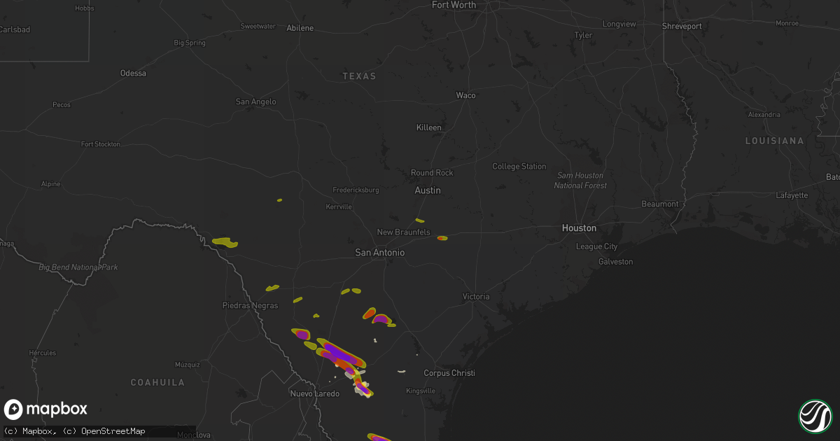
Hail Map on April 3, 2020
Get this storm
April 3 map
$229
one time, instant access
Download today. No call, no setup
Keep the $229
Bought the map and want the full workflow? Apply the entire $229 to a subscription within 7 days. None of it is wasted.
Every map, not just this one
This buys you this map. Subscription and you get every map we run, in the markets you choose from a few cities to whole states to nationwide. Plus real-time alerts the moment a storm fires.
Contact data
Name, contact info, occupancy, even credit band for addresses in the footprint. You go from where it hit to who to call.
Become the source they trust
Unlimited branding weather history reports on demand. You already have the documented answer ready for the property owner, and you are the one who showed up with it.
Property data and RoofTrace estimates
Pull up any address you have got, its value and the exact code rules for that jurisdiction, straight from One Click Code. Then RoofTrace estimates the squares, pitch, and roof value, priced the way you price.
States Impacted by Hail Map on April 3, 2020
Storm reports
Texas
| Date | Description |
|---|---|
| 04/03/20205:57 PM CDT | Time estimated from radar. Rv park report estimated 50-60mph winds. |
| 04/03/20205:34 PM CDT | A local report indicates 1.00 inch wind near CALLIHAM |
| 04/03/20205:21 PM CDT | Public reported hail sizes 2.0 to 3.0 inches in diameter. Photos and video also provided. |
| 04/03/20204:30 PM CDT | Downed power lines and broken power poles. |
| 04/03/20204:29 PM CDT | Nickel to quarter sized hail falling in martindale. |
| 04/03/20201:15 PM CDT | Public reported golf ball hail in bracketville. |
| 04/03/20201:00 PM CDT | A local report indicates 1.25 inch wind near 1 NNE ROUGH CANYON RECR |
| 04/03/20207:32 AM CDT | At 1232 PM CDT, a severe thunderstorm was located near Governors Landing, or 11 miles southeast of Comstock, moving northeast at 25 mph. HAZARD...Half dollar size hail. SOURCE...Radar indicated. IMPACT...Damage to vehicles is expected. Locations impacted include... Devils Shores, Rough Canyon Recreation Area, Spur 406 Campground and Salem Point. |
| 04/03/20205:59 AM CDT | At 1058 PM CDT, a severe thunderstorm was located 9 miles northeast of Bruni, or 16 miles north of Hebbronville, moving southeast at 30 mph. HAZARD...60 mph wind gusts and quarter size hail. SOURCE...Radar indicated. IMPACT...Hail damage to vehicles is expected. Expect wind damage to roofs, siding, and trees. Locations impacted include... Realitos. |
| 04/03/20205:28 AM CDT | At 1027 PM CDT, a severe thunderstorm was located 19 miles west of Freer, moving southeast at 30 mph. HAZARD...Ping pong ball size hail and 60 mph wind gusts. SOURCE...Radar indicated. IMPACT...People and animals outdoors will be injured. Expect hail damage to roofs, siding, windows, and vehicles. Expect wind damage to roofs, siding, and trees. Locations impacted include... Bruni and Ranchitos Las Lomas. |
| 04/03/20204:29 AM CDT | At 928 PM CDT, a severe thunderstorm was located near Encinal, moving southeast at 35 mph. HAZARD...Golf ball size hail and 60 mph wind gusts. SOURCE...Radar indicated. IMPACT...People and animals outdoors will be injured. Expect hail damage to roofs, siding, windows, and vehicles. Expect wind damage to roofs, siding, and trees. Locations impacted include... Encinal and Callaghan. |
| 04/03/20204:20 AM CDT | At 920 PM CDT, a severe thunderstorm was located over Goldfinch, or 9 miles west of Charlotte, moving east at 30 mph. HAZARD...60 mph wind gusts and quarter size hail. SOURCE...Radar indicated. IMPACT...Hail damage to vehicles is expected. Expect wind damage to roofs, siding, and trees. Locations impacted include... Pleasanton, Jourdanton, Charlotte, Christine, Goldfinch, Schattel, Coughran, Dobrowolski and Davis. |
| 04/03/20203:48 AM CDT | At 848 PM CDT, a severe thunderstorm was located near La Esperanza Ranch Airport, or 16 miles northwest of Encinal, moving east at 25 mph. HAZARD...60 mph wind gusts and half dollar size hail. SOURCE...Radar indicated. IMPACT...Hail damage to vehicles is expected. Expect wind damage to roofs, siding, and trees. Locations impacted include... Encinal and La Esperanza Ranch Airport. |
| 04/03/20202:55 AM CDT | At 754 PM CDT, a severe thunderstorm was located 11 miles south of Fort Ewell Site, or 21 miles east of Encinal, moving southeast at 35 mph. This is a very dangerous storm. HAZARD...Baseball size hail and 60 mph wind gusts. SOURCE...Radar indicated. IMPACT...People and animals outdoors will be severely injured. Expect shattered windows, extensive damage to roofs, siding, and vehicles. Locations impacted include... Freer, Fort Ewell Site and Seven Sisters. |
| 04/03/20202:21 AM CDT | At 720 PM CDT, a severe thunderstorm was located 8 miles south of Artesia Wells, or 8 miles northeast of Encinal, moving east at 30 mph. HAZARD...60 mph wind gusts and half dollar size hail. SOURCE...Radar indicated. IMPACT...Hail damage to vehicles is expected. Expect wind damage to roofs, siding, and trees. Locations impacted include... Encinal, Fort Ewell Site, Artesia Wells and Chaparral Wildlife Management Area. |
| 04/03/20201:11 AM CDT | At 610 PM CDT, a severe thunderstorm was located near Gilson Groves, or 12 miles south of Carrizo Springs, moving east at 35 mph. HAZARD...Quarter size hail. SOURCE...Radar indicated. IMPACT...Damage to vehicles is expected. Locations impacted include... Asherton, Chaparral Wildlife Management Area, Gilson Groves, Catarina and Light. |
| 04/03/202012:36 AM CDT | At 536 PM CDT, a severe thunderstorm was located near Palmeto State Park, or near Gonzales, moving east at 25 mph. HAZARD...Quarter size hail. SOURCE...Radar indicated. IMPACT...Damage to vehicles is expected. Locations impacted include... Gonzales, Waelder, Little New York, Nickle, Dilworth and Newtonville. |
| 04/03/202012:27 AM CDT | At 527 PM CDT, a severe thunderstorm was located over Calliham, or near Choke Canyon, moving east at 20 mph. HAZARD...Two inch hail and 60 mph wind gusts. SOURCE...Radar indicated. IMPACT...People and animals outdoors will be injured. Expect hail damage to roofs, siding, windows, and vehicles. Expect wind damage to roofs, siding, and trees. Locations impacted include... George West, Three Rivers, Choke Canyon, Calliham, Oakville, Simmons and Ray Point. |
| 04/03/202012:14 AM CDT | At 513 PM CDT, a severe thunderstorm was located near Calliham, or near Choke Canyon, moving east at 20 mph. HAZARD...Two inch hail and 60 mph wind gusts. SOURCE...Radar indicated. IMPACT...People and animals outdoors will be injured. Expect hail damage to roofs, siding, windows, and vehicles. Expect wind damage to roofs, siding, and trees. Locations impacted include... Choke Canyon, Tilden, Calliham, Simmons and Whitsett. |
| 04/02/202011:51 PM CDT | At 450 PM CDT, a severe thunderstorm was located over Cross, or 9 miles north of Tilden, moving northeast at 15 mph. HAZARD...60 mph wind gusts and quarter size hail. SOURCE...Radar indicated. IMPACT...Hail damage to vehicles is expected. Expect wind damage to roofs, siding, and trees. Locations impacted include... Cross, Zella and Crowther. |
| 04/02/202011:25 PM CDT | At 425 PM CDT, a severe thunderstorm was located over San Marcos, moving northeast at 20 mph. HAZARD...60 mph wind gusts and quarter size hail. SOURCE...Radar indicated. IMPACT...Hail damage to vehicles is expected. Expect wind damage to roofs, siding, and trees. Locations impacted include... Austin, San Marcos, Kyle, Lockhart, Austin Bergstrom Int Airport, Martindale, Uhland, Mustang Ridge, Niederwald, Staples, Creedmoor, San Marcos Regional Airport, Maha, Maxwell, Reedville, Redwood, Lytton Springs, Dale, St John Colony and Mendoza. |
| 04/02/20208:26 PM CDT | At 126 PM CDT, a severe thunderstorm was located 12 miles southeast of Darling, or 21 miles southeast of Spofford, moving east at 20 mph. HAZARD...Half dollar size hail. SOURCE...Radar indicated. IMPACT...Damage to vehicles is expected. This severe thunderstorm will remain over mainly rural areas of northeastern Maverick and northwestern Zavala Counties. |
| 04/02/20208:06 PM CDT | At 106 PM CDT, a severe thunderstorm was located 7 miles northeast of Lake View, or 10 miles north of Del Rio, moving east at 30 mph. HAZARD...Half dollar size hail. SOURCE...Radar indicated. IMPACT...Damage to vehicles is expected. Locations impacted include... Alamo Village, 277 North Campground, Kickapoo Cavern State Park, 277 South Boat Ramp and Lake Ridge Ranch. |
| 04/02/20208:06 PM CDT | Social media post reported at least golf ball size hail... 1.75 inches in diameter on hwy 44. Provided video. |
| 04/02/20207:58 PM CDT | Time estimated from radar. Public estimated larger than quarter size hail. Car got dented and side window broke. |
Cities Impacted by Hail Map on April 3, 2020
- Linn, TX
- Hebbronville, TX
- San Isidro, TX
- Santa Elena, TX
- Encino, TX
- Laredo, TX
- Realitos, TX
- Alice, TX
- Freer, TX
- Zapata, TX
- Tilden, TX
- Comstock, TX
- Del Rio, TX
- La Pryor, TX
- Quemado, TX
- Crystal City, TX
- Batesville, TX
- Rocksprings, TX
- Big Wells, TX
- Martindale, TX
- Maxwell, TX
- San Marcos, TX
- Charlotte, TX
- Jourdanton, TX
- Three Rivers, TX
- Calliham, TX
- Gonzales, TX
- Harwood, TX
- Asherton, TX
- Encinal, TX
- Pearsall, TX
- Bigfoot, TX
- Moore, TX
- Edinburg, TX
- Armstrong, TX