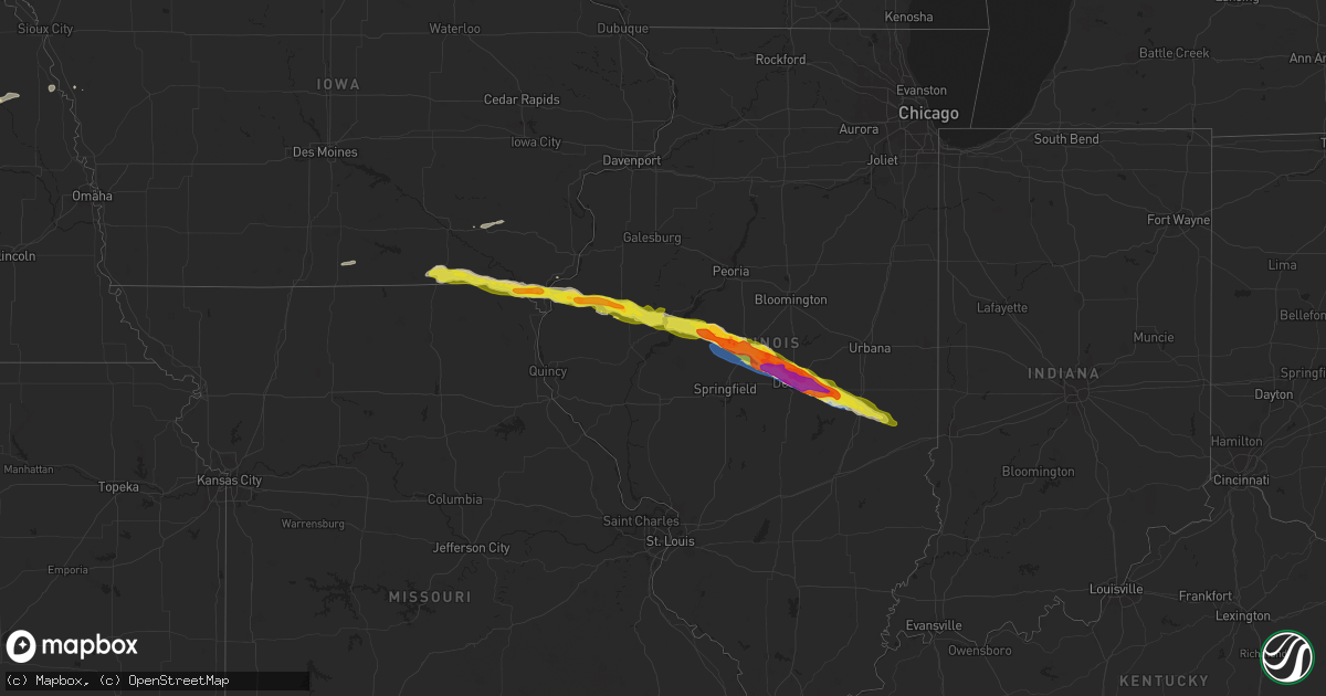
Hail Map on March 31, 2024
Get this storm
March 31 map
$229
one time, instant access
Download today. No call, no setup
Keep the $229
Bought the map and want the full workflow? Apply the entire $229 to a subscription within 7 days. None of it is wasted.
Every map, not just this one
This buys you this map. Subscription and you get every map we run, in the markets you choose from a few cities to whole states to nationwide. Plus real-time alerts the moment a storm fires.
Contact data
Name, contact info, occupancy, even credit band for addresses in the footprint. You go from where it hit to who to call.
Become the source they trust
Unlimited branding weather history reports on demand. You already have the documented answer ready for the property owner, and you are the one who showed up with it.
Property data and RoofTrace estimates
Pull up any address you have got, its value and the exact code rules for that jurisdiction, straight from One Click Code. Then RoofTrace estimates the squares, pitch, and roof value, priced the way you price.
Storm reports
Virginia
| Date | Description |
|---|---|
| 03/31/20245:14 PM CDT | A local report indicates 1.00 inch wind near Tyro |
| 03/31/20244:55 PM CDT | A local report indicates 1.00 inch wind near Fairfield |
| 03/31/20244:34 PM CDT | Tree down on power line. |
Illinois
| Date | Description |
|---|---|
| 03/31/20246:56 PM CDT | Golf ball size hail in middletown. |
| 03/31/20246:54 PM CDT | Tree blown down 1 mile sw of middletown. Social media report. |
| 03/31/20246:48 PM CDT | Tree and structural damage near home east of greenview along with 1 inch hail. |
| 03/31/20246:48 PM CDT | Quarter size hail with wind damage near greenview. |
| 03/31/20246:45 PM CDT | Quarter to half dollar size hail 1 mile south of mason city. |
| 03/31/20246:39 PM CDT | Golf ball size hail 3 miles sw of mason city. |
| 03/31/20246:34 PM CDT | A local report indicates 1.00 inch wind near Easton |
| 03/31/20246:19 PM CDT | Pea to quarter size hail in havana. |
| 03/31/20245:50 PM CDT | A local report indicates 1.00 inch wind near Ipava |
| 03/31/20245:50 PM CDT | Lots of quarter size hail reported 2.5 miles west of table grove il. |
| 03/31/20245:30 PM CDT | Several trained spotter reports of 1.00 to 1.25 inch hail in macomb. |
| 03/31/20245:28 PM CDT | Quarter size hail. |
| 03/31/20245:27 PM CDT | Report from mping: quarter |
| 03/31/20245:26 PM CDT | A local report indicates 1.25 inch wind near 5 ENE Fandon |
| 03/31/20245:26 PM CDT | Report from mping: ping pong ball |
| 03/31/20245:25 PM CDT | 5 minutes of half dollar size hail falling... And 10 minutes of hail the size of quarters falling. Hail nearly covering the ground. |
| 03/31/20245:23 PM CDT | Hail the size of quarters. Mostly dime to penny size. |
| 03/31/20245:21 PM CDT | Copious amounts of nickel hail with a couple of quarters mixed in lasting for 5 minutes. Still ongoing. |
| 03/31/20245:20 PM CDT | Hail the size of quarters. |
| 03/31/20244:52 PM CDT | Via social media. Time and location were estimated. |
| 03/31/20244:47 PM CDT | Report from mping: half dollar |
| 03/31/20244:35 PM CDT | Hail to the size of quarters. |
| 03/30/20248:31 PM CDT | A local report indicates 1.25 inch wind near Arthur |
| 03/30/20248:25 PM CDT | Report from mping: golf ball |
| 03/30/20248:17 PM CDT | Report from mping: ping pong ball |
| 03/30/20248:12 PM CDT | Report from mping: half dollar |
| 03/30/20248:05 PM CDT | A local report indicates 1.75 inch wind near Oakley |
| 03/30/20248:03 PM CDT | Report from mping: half dollar |
| 03/30/20248:01 PM CDT | Report from mping: quarter |
| 03/30/20248:00 PM CDT | Golf ball size hail for 10 minutes. |
| 03/30/20248:00 PM CDT | Swop report of golf ball size hail with photo. |
| 03/30/20248:00 PM CDT | Ping pong size hail at decatur zoo with photo. |
| 03/30/20247:58 PM CDT | Picture via social media. |
| 03/30/20247:57 PM CDT | A local report indicates 1.75 inch wind near Oreana |
| 03/30/20247:55 PM CDT | Report from mping: golf ball |
| 03/30/20247:55 PM CDT | A local report indicates 1.50 inch wind near Forsyth |
| 03/30/20247:52 PM CDT | A local report indicates 1.25 inch wind near 2 W Decatur |
| 03/30/20247:52 PM CDT | Photo from public of tennis ball size hail. |
| 03/30/20247:50 PM CDT | Picture via social media; wolf road. |
| 03/30/20247:50 PM CDT | Report from mping: quarter |
| 03/30/20247:50 PM CDT | Ping pong size hail on west side of decatur. |
| 03/30/20247:46 PM CDT | Picture via social media. |
| 03/30/20247:40 PM CDT | Report from mping: golf ball |
| 03/30/20247:38 PM CDT | A local report indicates 1.00 inch wind near Warrensburg |
| 03/30/20247:30 PM CDT | A local report indicates 1.75 inch wind near Latham |
| 03/30/20247:25 PM CDT | Report from mping: half dollar |
| 03/30/20247:22 PM CDT | A local report indicates 1.75 inch wind near Latham |
| 03/30/20247:22 PM CDT | A local report indicates 1.50 inch wind near Mount Pulaski |
| 03/30/20247:21 PM CDT | A local report indicates 2.00 inch wind near Mount Pulaski |
| 03/30/20247:20 PM CDT | Quarter size hail in mt pulaski. |
| 03/30/20247:15 PM CDT | Ping report of half dollar size hail. |
| 03/30/20247:15 PM CDT | Quarter size hail on west side of lincoln. |
| 03/30/20247:05 PM CDT | Pea to marble size hail with 60 mph wind gust. |
Iowa
| Date | Description |
|---|---|
| 03/31/20244:21 PM CDT | Time estimated using radar. |
| 03/31/20243:59 PM CDT | Dime to quarter size hail. Report was delayed. Time of the event was estimated using radar.... |
| 03/31/20243:36 PM CDT | A local report indicates 1.00 inch wind near 1 ENE Milton |
| 03/31/20243:36 PM CDT | Pea hail. |
Nebraska
| Date | Description |
|---|---|
| 03/31/20244:15 AM CDT | Corrects previous tstm wnd dmg report from 4 s stanton. Damage was actually south of pilger... Ne and not stanton... Ne. Over 20 power poles down... Tin outbuilding had |
| 03/31/20244:15 AM CDT | About 1/2 mile of power lines blown down. |
| 03/31/20244:06 AM CDT | Mostly 1/2 inch hail with a stone or two up to quarter size. Ground was white from hail. |
| 03/31/20244:03 AM CDT | Over 20 power poles down... Tin outbuilding had portion of roof blown off... Large tree limb broken. Time estimated from radar. |
Missouri
| Date | Description |
|---|---|
| 03/31/20243:54 PM CDT | A local report indicates 1.00 inch wind near 3 W Charlie Heath Memor |
California
| Date | Description |
|---|---|
| 03/31/20242:27 PM CDT | Downed tree and powerlines. |
| 03/31/202411:21 AM CDT | Downed tree. |
| 03/30/20249:54 PM CDT | California highway patrol reported a downed tree at the junction of ca highway 99 and ca highway 166. |
Cities Impacted by Hail Map on March 31, 2024
- Bloomfield, IA
- Moulton, IA
- Pulaski, IA
- Memphis, MO
- Milton, IA
- Cantril, IA
- Arbela, MO
- Luray, MO
- Mount Sterling, IA
- Kahoka, MO
- Wayland, MO
- Keosauqua, IA
- Revere, MO
- Farmington, IA
- Argyle, IA
- Donnellson, IA
- Montrose, IA
- Keokuk, IA
- Nauvoo, IL
- Hamilton, IL
- Dallas City, IL
- Niota, IL
- Carthage, IL
- Rockbridge Baths, VA
- Fairfield, VA
- Lexington, VA
- Goshen, VA
- La Harpe, IL
- Colchester, IL
- Blandinsville, IL
- Tennessee, IL
- Vesuvius, VA
- Macomb, IL
- Arrington, VA
- Tyro, VA
- Roseland, VA
- Piney River, VA
- Adair, IL
- Industry, IL
- Table Grove, IL
- Vermont, IL
- Ipava, IL
- Lovingston, VA
- Lewistown, IL
- Astoria, IL
- Havana, IL
- Bath, IL
- Timewell, IL
- Mount Sterling, IL
- Rushville, IL
- Frederick, IL
- Browning, IL
- Clayton, IL
- Topeka, IL
- Easton, IL
- Forest City, IL
- Mason City, IL
- Kilbourne, IL
- San Jose, IL
- Greenview, IL
- Middletown, IL
- New Holland, IL
- Lincoln, IL
- Elkhart, IL
- Athens, IL
- Wingina, VA
- Shipman, VA
- Hartsburg, IL
- Mount Pulaski, IL
- Beason, IL
- Chestnut, IL
- Latham, IL
- Kenney, IL
- Maroa, IL
- Warrensburg, IL
- Williamsville, IL
- Illiopolis, IL
- Niantic, IL
- Decatur, IL
- Forsyth, IL
- Harristown, IL
- Oreana, IL
- Argenta, IL
- Mt Zion, IL
- Cerro Gordo, IL
- Lovington, IL
- Dalton City, IL
- La Place, IL
- Hammond, IL
- Atwood, IL
- Arthur, IL
- Tuscola, IL
- Arcola, IL
- Humboldt, IL
- Sullivan, IL
- Hindsboro, IL
- Novinger, MO
- Pleasant Plains, IL
- Lewistown, MO
- Mechanicsburg, IL
- Hurdland, MO
- Riverton, IL
- Macon, IL
- Green City, MO
- Mount Auburn, IL
- Blue Mound, IL
- Edina, MO
- Beardstown, IL
- Mendon, IL
- Paloma, IL
- Quincy, IL
- Coatsburg, IL
- Princeton, MO
- Brashear, MO
- Green Castle, MO
- Buffalo, IL
- Springfield, IL
- Camp Point, IL
- La Grange, MO
- Arenzville, IL
- Ridgeway, MO
- Milan, MO
- Fowler, IL
- Ashland, IL
- Kirksville, MO
- Virginia, IL
- Dawson, IL
- Charleston, IL
- Oakland, IL
- Ashmore, IL
- Kansas, IL
- Corydon, IA
- Fairfield, IA
- Brighton, IA
- Fort Madison, IA
- Madison, NE
- Lindsay, NE
- Norfolk, NE
- Stanton, NE
- Pilger, NE
- Wisner, NE
- Beemer, NE
- Bancroft, NE
- Pender, NE
- Decatur, NE
- Macy, NE
- Onawa, IA
- Lyons, NE
- Rosalie, NE