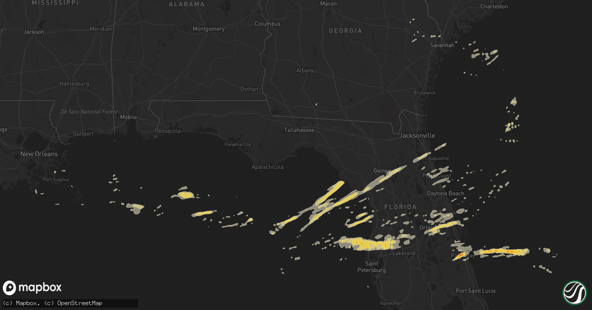
Hail Map on March 30, 2011
Get this storm
March 30 map
$229
one time, instant access
Download today. No call, no setup
Keep the $229
Bought the map and want the full workflow? Apply the entire $229 to a subscription within 7 days. None of it is wasted.
Every map, not just this one
This buys you this map. Subscription and you get every map we run, in the markets you choose from a few cities to whole states to nationwide. Plus real-time alerts the moment a storm fires.
Contact data
Name, contact info, occupancy, even credit band for addresses in the footprint. You go from where it hit to who to call.
Become the source they trust
Unlimited branding weather history reports on demand. You already have the documented answer ready for the property owner, and you are the one who showed up with it.
Property data and RoofTrace estimates
Pull up any address you have got, its value and the exact code rules for that jurisdiction, straight from One Click Code. Then RoofTrace estimates the squares, pitch, and roof value, priced the way you price.
Storm reports
Florida
| Date | Description |
|---|---|
| 03/30/20114:59 PM CDT | Kmlb at melbourne international airport measured 51 kt/58 mph wind gust. |
| 03/30/20114:50 PM CDT | Wind damage along north banana river drive and central ave. Patio destroyed and lifted over house into front yard. Damage to wooden fences and tree limbs down. |
| 03/30/20114:46 PM CDT | Kcof measured 54 kt/62 mph wind gust. |
| 03/30/20114:15 PM CDT | Report of quarter sized hail on the a1a bridge. |
| 03/30/20114:12 PM CDT | Screen porch roof blown off and walls blown in on vermont ave. Time estimated by radar. |
| 03/30/20114:12 PM CDT | Tree down on powerlines on 3rd st. Time estimated by radar. |
| 03/30/20114:12 PM CDT | Tree on home on marina dr. |
| 03/30/20114:11 PM CDT | Tractor trailer overturned on i-95 at mm 226. |
| 03/30/20114:10 PM CDT | Large tree down on a house and powerlines on delaware ave. Time estimated by radar. |
| 03/30/20114:10 PM CDT | Numerous limbs torn off trees. |
| 03/30/20114:10 PM CDT | Tree on house on old tampa hwy rd. |
| 03/30/20114:10 PM CDT | Aluminum canopy trim damaged at fire station. Time estimated by radar. |
| 03/30/20114:09 PM CDT | Numerous large oak trees down over a 1/4 mile radius. Time estimated by radar. |
| 03/30/20114:07 PM CDT | Multiple trees down |
| 03/30/20114:05 PM CDT | Thigh-sized limbs down. Winds estimated at 70 mph. |
| 03/30/20114:00 PM CDT | Power lines and trees down in ocala national forest. Helicopter pivoted on its pad. |
| 03/30/20114:00 PM CDT | Very large 30 foot tall tree fell on home destroying corner of roof near intersection of spruce creek road and sun lake drive. |
| 03/30/20113:55 PM CDT | Tree limbs across road at intersection of courtland and doyle. |
| 03/30/20113:55 PM CDT | Car port collapsed and roof damage on kingfish st. Time estimated by radar. |
| 03/30/20113:55 PM CDT | Multiple trees and wires reported down in the lehigh woods section of palm coast. |
| 03/30/20113:55 PM CDT | Damage to older mobile home on forest drive. Wind gust estimated at 50 mph. |
| 03/30/20113:55 PM CDT | One large oak tree uprooted at corner of dunblane and whitehall. Time estimated by radar. |
| 03/30/20113:52 PM CDT | 2 trees uprooted with diameters up to about 6 inches. |
| 03/30/20113:50 PM CDT | Kism at kissimmee airport measured 51 kt/58 mph wind gust. |
| 03/30/20113:50 PM CDT | A tree fell on a home off richland lane. No injuries were reported. |
| 03/30/20113:50 PM CDT | Tree down partially blocking road on 2nd street at cyprus st. |
| 03/30/20113:48 PM CDT | Kmco at orlando international airport measured 53 kt/60 mph wind gust. |
| 03/30/20113:48 PM CDT | Ksfb at orlando sanford airport measured 57 kt/65 mph wind gust. |
| 03/30/20113:47 PM CDT | Two large trees down on a home on smyrna drive. |
| 03/30/20113:45 PM CDT | Nickel size hail with quarter size mixed in at waterford lakes shopping center. |
| 03/30/20113:45 PM CDT | Fence blown across the road and fiberglass tabletop blown off. Fence posts snapped off. |
| 03/30/20113:45 PM CDT | Back porch blown off home. |
| 03/30/20113:45 PM CDT | Straight line winds tore a roof off a mobile home on starboard drive in beverly beach. |
| 03/30/20113:45 PM CDT | Trees down on 5 cars in wofl parking lot. |
| 03/30/20113:45 PM CDT | Trees down at north st and suniland st blocking roadway. |
| 03/30/20113:45 PM CDT | One tree down at goldenrod and sunvista roads. |
| 03/30/20113:44 PM CDT | Korl at orlando executive airport measured 65 kt/74 mph wind gust. Wind overturned multiple small aircraft. |
| 03/30/20113:44 PM CDT | Emergency management reported a tree down on a house off richmond drive. Power lines were also down. |
| 03/30/20113:43 PM CDT | Straight line winds damaged pool screens in northeast palm coast. Dime size hail was also reported. |
| 03/30/20113:43 PM CDT | A trained spotter measured a wind gust of 62 mph in northeast palm coast. |
| 03/30/20113:40 PM CDT | 2-3 trees down on i-95 south of garden st. |
| 03/30/20113:40 PM CDT | Multiple trees down on acorn court. |
| 03/30/20113:39 PM CDT | Estimated 60+ mph sustained winds. Tree limbs down and power out. |
| 03/30/20113:38 PM CDT | Quarter size hail and a funnel cloud reported at bird of paradise drive and belle terre parkway. |
| 03/30/20113:35 PM CDT | 2 trees down. |
| 03/30/20113:30 PM CDT | Trees and power lines reported down at highway 207 and interstate 95 and continuing eastward toward saint augustine. |
| 03/30/20113:30 PM CDT | One large tree down on route 46. |
| 03/30/20113:30 PM CDT | One tree down |
| 03/30/20113:23 PM CDT | Trees and power lines down. Greenhouse damaged. |
| 03/30/20113:20 PM CDT | Very large oak tree uprooted. Multiple 4 to 5 inch diameter branches on the ground. |
| 03/30/20113:18 PM CDT | Roof ripped off house. Time is estimated by radar. |
| 03/30/20113:15 PM CDT | Multiple large tree limbs down. |
| 03/30/20113:15 PM CDT | Spotter reported hail up to 2 inches and strong winds. |
| 03/30/20113:10 PM CDT | The public reported tree limbs down in dade city. |
| 03/30/20113:06 PM CDT | Reports from the field of trees down and damage to a pole barn in dade city. |
| 03/30/20113:05 PM CDT | A cocorahs spotter reported trees down...strong winds...lots of debris. Rainfall amount of 0.64 inches fell in five minutes. Time of report is based on radar. |
| 03/30/20113:00 PM CDT | Multiple trees were down with one tree across a fence on lewis pond road. The spotter reported a wind gust of 47 mph and one half inch of rain. |
| 03/30/20112:52 PM CDT | Reported from home weather station. |
| 03/30/20112:45 PM CDT | The public reported to 911 trees and power lines down and a roof off of a home. Not confirmed yet by emergency management. |
| 03/30/20112:33 PM CDT | The public reported to 911 wind damage and a possible tornado at west fort island trail road. |
| 03/30/20112:30 PM CDT | A large tree fell onto three cars in the beacon woods area. |
| 03/30/20112:19 PM CDT | Emergency management reported power lines down and trees down into power lines near riverside drive and 63rd street. Also a tree fell onto a home on knotts way. Time es |
| 03/30/20112:06 PM CDT | Emergency manager reported trees down and a pole barn damaged near state road 129 and 240th street in the obrien vicinity. Time is estimated based on radar. |
| 03/30/20111:38 PM CDT | Trees and power lines down with power outages and debris in the road. Utility company and law enforcement investigating with details to follow. |
| 03/30/20111:34 PM CDT | Trees down |
| 03/30/20116:40 AM CDT | Estimated 60 mph wind gust and small tree limbs down. |
| 03/30/20116:34 AM CDT | Hail up to quarter size reported around the world golf village. |
| 03/30/20116:00 AM CDT | Damage to carports and pool cages in lake padgett estates neighborhood of land o lakes. |
| 03/30/20116:00 AM CDT | A convenient store clerk along state road 26 reported hail around 1 inch in diameter. |
| 03/30/20115:58 AM CDT | Trees down near river ridge blvd and tall pines blvd. Reported by pasco county sheriffs office. |
| 03/30/20115:36 AM CDT | Comps station at anclote gulf park measured a wind gust of 53 knots. |
| 03/29/201111:25 PM CDT | Wind speed measured by home weather station. |
Georgia
| Date | Description |
|---|---|
| 03/30/20117:15 AM CDT | Emergency management reported a few powerlines down across central portions of the county. |
Cities Impacted by Hail Map on March 30, 2011
- Wesley Chapel, FL
- Clermont, FL
- Polk City, FL
- Zephyrhills, FL
- Lutz, FL
- Odessa, FL
- Tampa, FL
- Mims, FL
- Orlando, FL
- Titusville, FL
- Christmas, FL
- Homosassa, FL
- Palm Harbor, FL
- Plant City, FL
- Tarpon Springs, FL
- Dade City, FL
- Thonotosassa, FL
- San Antonio, FL
- Land O'Lakes, FL
- New Port Richey, FL
- Port Richey, FL
- Holiday, FL
- Statesboro, GA
- Brooklet, GA
- Floral City, FL
- Pembroke, GA
- Green Cove Springs, FL
- Saint Augustine, FL
- Cedar Key, FL
- Hudson, FL
- Spring Hill, FL
- Osteen, FL
- Sanford, FL
- Palm Bay, FL
- Palm Coast, FL
- Hastings, FL
- Geneva, FL
- Oak Hill, FL
- Oviedo, FL
- Longwood, FL
- Lake Mary, FL
- Debary, FL
- Winter Springs, FL
- Deltona, FL
- Rockledge, FL
- Melbourne, FL
- Ellabell, GA
- Thomasville, GA
- Coolidge, GA
- Hawthorne, FL
- Grant, FL
- Horseshoe Beach, FL
- Tavares, FL
- Mount Dora, FL
- Crystal River, FL
- Lakeland, FL
- Crystal Beach, FL
- Kathleen, FL
- Malabar, FL
- Lecanto, FL
- Palatka, FL
- Maitland, FL
- Winter Park, FL
- Altamonte Springs, FL
- Casselberry, FL
- Brooksville, FL
- Florahome, FL
- Interlachen, FL
- Earleton, FL
- Melrose, FL
- Williston, FL
- Archer, FL
- Micanopy, FL
- Otter Creek, FL
- Gainesville, FL
- Bronson, FL
- Chiefland, FL
- Inglis, FL
- Morriston, FL
- East Palatka, FL
- Elkton, FL
- The Villages, FL
- Wildwood, FL
- Leesburg, FL
- Sumterville, FL
- Golden Meadow, LA
- Port Wentworth, GA
- Bunnell, FL
- Howey In The Hills, FL
- Apopka, FL
- Rincon, GA
- Guyton, GA
- Bushnell, FL
- Lake Panasoffkee, FL
- Satellite Beach, FL
- Indialantic, FL
- Melbourne Beach, FL
- Patrick Afb, FL
- Merritt Island, FL
- Saint Cloud, FL
- Ormond Beach, FL
- Flagler Beach, FL
- Groveland, FL