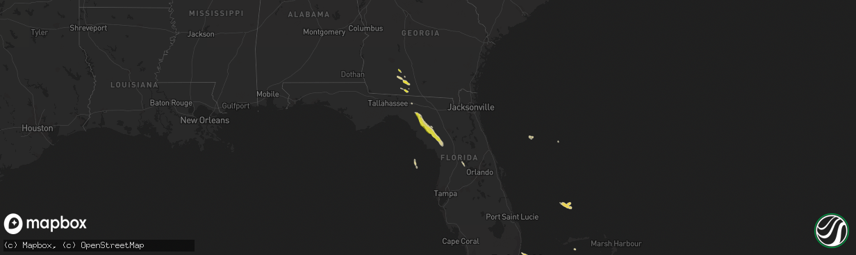
Hail Map on March 26, 2019
The weather event on March 26, 2019 includes Hail map. 3 states and 26 cities were impacted and suffered possible damage. The total estimated number of properties impacted is 6,074.
Want more than just the map?
Turn this storm into a full workflow.
- Owner + property data so you know who to knock
- OnDemand branded weather history reports to win the "did we even have hail?" argument
- RoofTrace estimate so reps stop guessing numbers at the door
Bought this map? Upgrade within 7 days and we'll credit the $230. (10-15 min setup call)
Hail
6,074
Estimated number of impacted properties by a 1.00" hail or larger0
Estimated number of impacted properties by a 1.75" hail or larger0
Estimated number of impacted properties by a 2.50" hail or largerStorm reports
Florida
| Date | Description |
|---|---|
| 03/26/20196:45 AM CDT | Quarter size hail in the hawthorne at leesburg area. Reported by trained weather spotter. |
| 03/26/20196:11 AM CDT | At 1111 PM EDT, severe thunderstorms were located along a line extending from 6 miles north of Pavo to 8 miles southeast of Boston, moving southeast at 15 mph. HAZARD...Quarter size hail. SOURCE...Radar indicated. IMPACT...Damage to vehicles is expected. Locations impacted include... Quitman, Moultrie, Pavo, Morven, Berlin, Barwick, Dixie, Barney, Grooverville, Autreyville, Oaklawn, Pidcock, Nankin, Empress, Brooks Co A/p, Blue Springs and Hollis. |
| 03/26/20192:15 AM CDT | Hail accumulated on the ground from pea to quarter size in the old town area. |
Georgia
| Date | Description |
|---|---|
| 03/26/20195:38 AM CDT | At 1038 PM EDT, a severe thunderstorm was located near Doerun, or 9 miles northwest of Moultrie, moving southeast at 10 mph. HAZARD...Quarter size hail. SOURCE...Radar indicated. IMPACT...Damage to vehicles is expected. Locations impacted include... Moultrie, Norman Park, Doerun, Riverside, Schley, Minton, Sigsbee, Anderson City, Crosland, New Elm, Minnesota and South Moultrie. |
| 03/25/201910:35 PM CDT | Social media picture of accumulating hail from the sand hill area. |
| 03/25/201910:21 PM CDT | Public estimated hail ranging from dime to quarter size in the dixie area. |
| 03/25/201910:12 PM CDT | Report of hail from the pavo area. |
| 03/25/20199:38 PM CDT | Report of quarter size hail from just east of doerun. |
Texas
| Date | Description |
|---|---|
| 03/26/20193:27 AM CDT | At 825 PM MDT, a severe thunderstorm was located 12 miles east of Sierra Blanca, moving southeast at 25 mph. Meanwhile, additional strong thunderstorms were moving northeast over the Eagle Mountains. Additional thunderstorms are likely to develop along Interstate 10 as these storms merge. HAZARD...60 mph wind gusts and quarter size hail. SOURCE...Radar indicated. IMPACT...Hail damage to vehicles is expected. Expect wind damage to roofs, siding, and trees. Locations impacted include... Sierra Blanca... Allamoore... Frenchman Canyon... Green River... and Sunset Ranches.Portions of Interstate 10 between Sierra Blanca and Van Horn are to be impacted. Sudden wind gusts and large hail are possible. Hail may cover the roadway in places. |
| 03/26/20192:42 AM CDT | At 741 PM MDT, a severe thunderstorm was located 15 miles north of Sierra Blanca, moving southeast at 15 mph. HAZARD...60 mph wind gusts and half dollar size hail. SOURCE...Radar indicated. IMPACT...Hail damage to vehicles is expected. Expect wind damage to roofs, siding, and trees. Locations impacted include... Sunset Ranches... and Round Top Mountain.Portions of Highway 1111 north of Sierra Blanca will also be impacted. Hail may accumulate on the road in places. |
| 03/26/20191:59 AM CDT | At 658 PM MDT, a severe thunderstorm was located 15 miles north of Finlay, moving east at 20 mph. HAZARD...60 mph wind gusts and half dollar size hail. SOURCE...Radar indicated. IMPACT...Hail damage to vehicles is expected. Expect wind damage to roofs, siding, and trees. Locations impacted include... Sunset Ranches. |