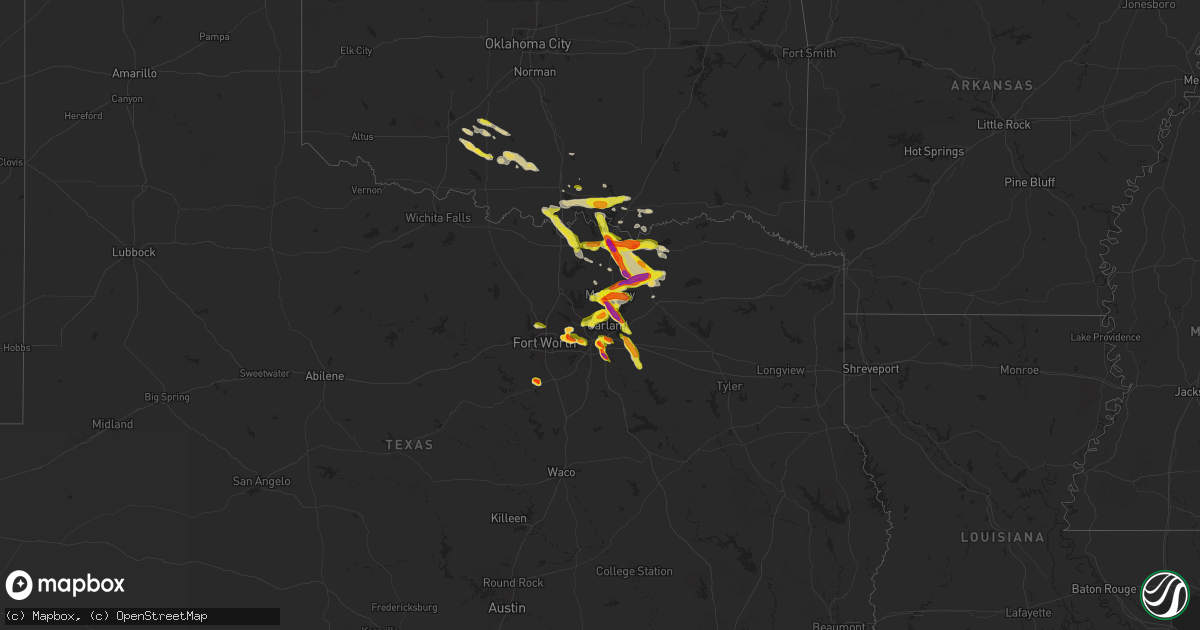
Hail Map on March 25, 2025
Get this storm
March 25 map
$229
one time, instant access
Download today. No call, no setup
Keep the $229
Bought the map and want the full workflow? Apply the entire $229 to a subscription within 7 days. None of it is wasted.
Every map, not just this one
This buys you this map. Subscription and you get every map we run, in the markets you choose from a few cities to whole states to nationwide. Plus real-time alerts the moment a storm fires.
Contact data
Name, contact info, occupancy, even credit band for addresses in the footprint. You go from where it hit to who to call.
Become the source they trust
Unlimited branding weather history reports on demand. You already have the documented answer ready for the property owner, and you are the one who showed up with it.
Property data and RoofTrace estimates
Pull up any address you have got, its value and the exact code rules for that jurisdiction, straight from One Click Code. Then RoofTrace estimates the squares, pitch, and roof value, priced the way you price.
Storm reports
Oklahoma
| Date | Description |
|---|---|
| 03/25/20256:28 PM CDT | A local report indicates 1.00 inch wind near 1 E Dickson |
| 03/25/202512:17 AM CDT | Report from mping: quarter |
| 03/25/202512:05 AM CDT | A local report indicates 1.25 inch wind near 1 N Kingston |
| 03/24/202511:14 PM CDT | A local report indicates 1.00 inch wind near 3 NNE Burneyville |
Texas
| Date | Description |
|---|---|
| 03/25/20256:10 PM CDT | A local report indicates 1.75 inch wind near 3 SSE Dallas |
| 03/25/20255:56 PM CDT | A local report indicates 1.00 inch wind near 1 WSW Denison |
| 03/25/20255:46 PM CDT | A local report indicates 1.75 inch wind near 2 NNE Cleburne |
| 03/25/20255:32 PM CDT | Mping report of 1.00 inch hail. |
| 03/25/202512:15 AM CDT | Nws employee reported family member in callisburg had mostly dime size hail with some quarter size hail mixed in. |
| 03/24/202511:52 PM CDT | Report from mping: quarter |
| 03/24/202511:35 PM CDT | Trained spotter reports quarter sized hail 3 miles north of ector. |
| 03/24/202511:22 PM CDT | Facebook photos showed golf ball size hail fell north of savoy. |
| 03/24/202511:15 PM CDT | Emergency managment reports ping pong ball sized hail in bells. |
| 03/24/202510:56 PM CDT | Report from mping: quarter |
| 03/24/202510:56 PM CDT | Report from mping: quarter |
| 03/24/202510:52 PM CDT | Emergency management reports 1.25 inch hail in sherman near at washington and 1417. |
| 03/24/202510:21 PM CDT | Facebook video showed large amounts of pea to quarter size hail falling in forney. |
| 03/24/20259:53 PM CDT | Half dollar sized hail reported in downtown princeton. |
| 03/24/20259:40 PM CDT | Hail up to ping pong ball size accumulated 4 to 6 inches deep at wylie fire station 1 on s. Ballard st. |
| 03/24/20259:33 PM CDT | Trained spotter reported ping pong sized hail and estimated 60 mph winds. |
| 03/24/20259:31 PM CDT | Ping pong hail reported at hardin and eldorado in mckinney. |
| 03/24/20259:30 PM CDT | Half dollar hail reported at lake forest and 380 in west mckinney. |
| 03/24/20259:25 PM CDT | One inch hail reported at park and country club in wylie. |
| 03/24/20259:25 PM CDT | Hail up to half dollar size covering the ground up to 2 inches deep in some places near park and country club in parker. |
| 03/24/20259:24 PM CDT | Delayed report. Ham radio reports quarter sized hail in wolfe city near hanna st and jackson st. |
| 03/24/20259:11 PM CDT | One inch hail reported by leonard vfd. |
| 03/24/20259:10 PM CDT | Ping pong hail reported at city of parker fire station. |
| 03/24/20259:10 PM CDT | Golf ball hail in east aleen. |
| 03/24/20259:09 PM CDT | Delayed report from mping: golf ball |
| 03/24/20259:06 PM CDT | Mping report of 2 inch hail. |
| 03/24/20259:03 PM CDT | Social media photos showed hail up to golf ball size fell near hwy 69 at cr 1145. |
| 03/24/20258:42 PM CDT | Golf ball sized hail reported 1 mile north of tom bean. |
| 03/24/20258:40 PM CDT | A local report indicates 1.50 inch wind near Luella |
| 03/24/20258:39 PM CDT | A local report indicates 1.50 inch wind near 2 NW Fairview |
| 03/24/20258:35 PM CDT | Mostly 0.5 to 0.75 inch hail but a few 1 inch hail mixed in. |
| 03/24/20258:26 PM CDT | Quarter sized hail report from mping. |
| 03/24/20258:20 PM CDT | Pea to quarter size hail fell for 5 minutes. |
| 03/24/20258:17 PM CDT | A local report indicates 1.75 inch wind near 2 N Sherman |
| 03/24/20258:13 PM CDT | Delayed report from mping: ping pong ball |
| 03/24/20258:10 PM CDT | Quarter sized hail with a few half dollar sized hail stones mixed in at kxii in north sherman. This lasted approximately 4 minutes. |
| 03/24/20257:59 PM CDT | Quarter sized hail reported at hannah drive on preston peninsula. |
| 03/24/20257:59 PM CDT | Quarter sized hail reported at ut dallas. |
| 03/24/20257:55 PM CDT | One inch hail measured near gb turnpike and coit rd that lasted approx 4 minutes. |
| 03/24/20257:36 PM CDT | Report from mping: ping pong ball |
| 03/24/20257:23 PM CDT | Mping report of 1.75 inch hail. |
| 03/24/20257:20 PM CDT | A local report indicates 1.00 inch wind near 3 NE Leonard |
| 03/24/20257:12 PM CDT | Delayed report from mping: ping pong ball |
| 03/24/20257:08 PM CDT | Delayed report. Social media image of ping pong sized hail in wilmer. |
Florida
| Date | Description |
|---|---|
| 03/25/20251:05 PM CDT | Ares operator relayed a report of downed power lines near sw 87th ave and sw 131 st near the falls. Time estimated from radar. |
| 03/25/202512:48 PM CDT | A member of the public in leisure city reported hail to the size of quarter dollars covering his yard. |
| 03/25/202512:46 PM CDT | Social media report of quarter sized hail ongoing for 15 minutes near the intersection of campbell drive and sw 137th avenue in homestead. |
| 03/25/202512:45 PM CDT | Trained spotter reported downed tree limbs... A damaged fence... And pea-sized hail near sw 167 ave and sw 264 st. |
Cities Impacted by Hail Map on March 25, 2025
- Fort Pierce, FL
- Homestead, FL
- Miami, FL
- Hialeah, FL
- Vero Beach, FL
- Jupiter, FL
- Stuart, FL
- Hobe Sound, FL
- Dallas, TX
- Jensen Beach, FL
- Cleburne, TX
- Denison, TX
- Pottsboro, TX
- Joshua, TX
- Mesquite, TX
- Balch Springs, TX
- Okeechobee, FL
- Sherman, TX
- Indiantown, FL
- Ardmore, OK
- Madill, OK
- Palm City, FL
- Canal Point, FL
- Hutchins, TX
- Whitewright, TX
- Bells, TX
- Ector, TX
- Savoy, TX
- Wilmer, TX
- Ferris, TX
- Bonham, TX
- Trenton, TX
- Randolph, TX
- Lancaster, TX
- Euless, TX
- Arlington, TX
- Grand Prairie, TX
- Leonard, TX
- Kingston, OK
- Wolfe City, TX
- Carrollton, TX
- Irving, TX
- Addison, TX
- Richardson, TX
- Plano, TX
- Garland, TX
- Allen, TX
- Mckinney, TX
- Frisco, TX
- Fort Worth, TX
- Bedford, TX
- Hurst, TX
- Grapevine, TX
- Wylie, TX
- Howe, TX
- Tom Bean, TX
- Melissa, TX
- Princeton, TX
- Blue Ridge, TX
- Anna, TX
- Farmersville, TX
- Celeste, TX
- Van Alstyne, TX
- Little Elm, TX
- Sachse, TX
- Rowlett, TX
- Rockwall, TX
- Lavon, TX
- Gunter, TX
- Forney, TX
- Terrell, TX
- Whitesboro, TX
- Crandall, TX
- Kaufman, TX
- Haslet, TX
- Gainesville, TX
- Collinsville, TX
- Tioga, TX
- Burneyville, OK
- Overbrook, OK
- Marietta, OK
- Thackerville, OK
- Ravenna, TX
- Marlow, OK
- Davis, OK
- Hendrix, OK
- Sulphur, OK
- Duncan, OK
- Windom, TX
- Dodd City, TX
- Graham, OK
- Bailey, TX
- Mead, OK
- Ratliff City, OK
- Healdton, OK
- Springer, OK
- Wilson, OK
- Lawton, OK
- Durant, OK
- Colbert, OK
- Walters, OK
- Bokchito, OK
- Comanche, OK
- Fletcher, OK
- Elgin, OK
- Celina, TX
- Flower Mound, TX
- Keller, TX
- Roanoke, TX
- The Colony, TX
- Southlake, TX
- Lewisville, TX
- Rush Springs, OK
- Honey Grove, TX
- Ivanhoe, TX
- Greenville, TX
- Lebanon, OK