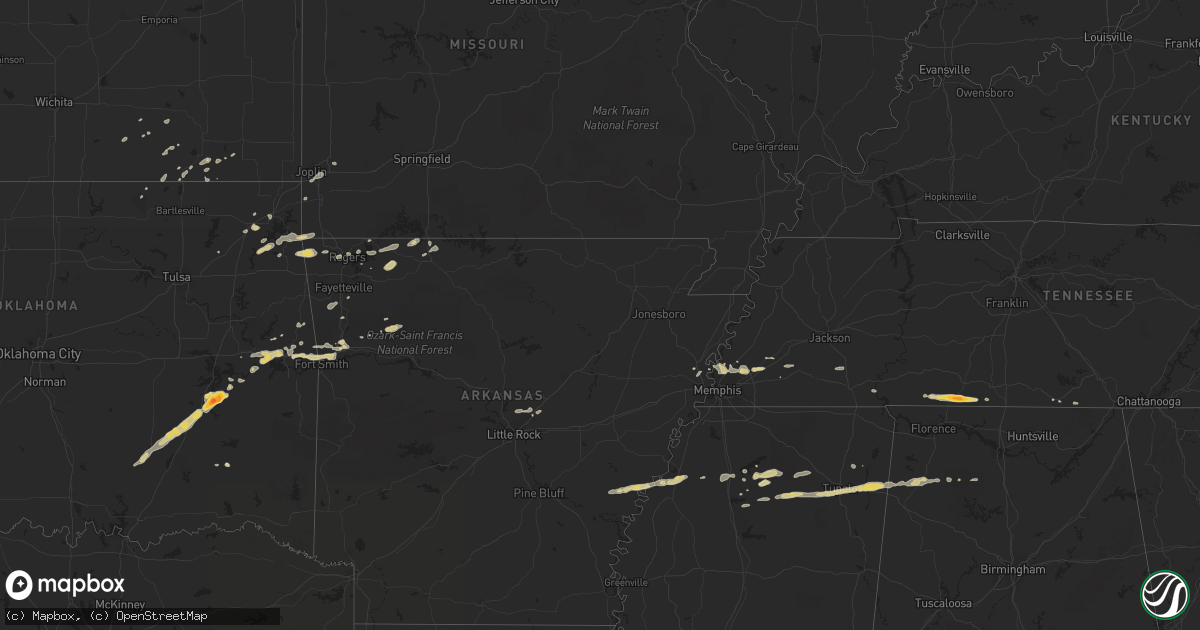
Hail Map on March 25, 2011
Get this storm
March 25 map
$229
one time, instant access
Download today. No call, no setup
Keep the $229
Bought the map and want the full workflow? Apply the entire $229 to a subscription within 7 days. None of it is wasted.
Every map, not just this one
This buys you this map. Subscription and you get every map we run, in the markets you choose from a few cities to whole states to nationwide. Plus real-time alerts the moment a storm fires.
Contact data
Name, contact info, occupancy, even credit band for addresses in the footprint. You go from where it hit to who to call.
Become the source they trust
Unlimited branding weather history reports on demand. You already have the documented answer ready for the property owner, and you are the one who showed up with it.
Property data and RoofTrace estimates
Pull up any address you have got, its value and the exact code rules for that jurisdiction, straight from One Click Code. Then RoofTrace estimates the squares, pitch, and roof value, priced the way you price.
States Impacted by Hail Map on March 25, 2011
Storm reports
Oklahoma
| Date | Description |
|---|---|
| 03/25/20114:50 AM CDT | A local report indicates 1.00 inch wind near 4 S AFTON |
| 03/25/20111:49 AM CDT | Quarter to just larger than quarter size hail. |
| 03/25/201112:52 AM CDT | A local report indicates 1.00 inch wind near 4 NE SALLISAW |
| 03/25/201112:48 AM CDT | A local report indicates 2.00 inch wind near BLOCKER |
| 03/25/201112:30 AM CDT | A local report indicates 1.00 inch wind near SAVANNA |
Alabama
| Date | Description |
|---|---|
| 03/25/20112:26 AM CDT | A local report indicates 1.00 inch wind near OHATCHEE |
Missouri
| Date | Description |
|---|---|
| 03/25/20115:43 AM CDT | Emergency management reported quarter sized hail at intersection of 20th and kenser roads. |
Arkansas
| Date | Description |
|---|---|
| 03/25/20116:10 AM CDT | A local report indicates 1.00 inch wind near 1 SW GRANDVIEW |
| 03/25/20116:00 AM CDT | A local report indicates 1.00 inch wind near BERRYVILLE |
| 03/25/20115:40 AM CDT | A local report indicates 1.00 inch wind near 2 E CABOT |
| 03/25/20111:36 AM CDT | Pea to quarter size hail covering the ground. |
| 03/25/20111:05 AM CDT | A local report indicates 1.00 inch wind near MARBLE FALLS |
Tennessee
| Date | Description |
|---|---|
| 03/25/20114:35 AM CDT | A local report indicates 1.00 inch wind near GALLAWAY |
| 03/25/20112:56 AM CDT | Hail covering the ground...some to golfball size...at loretto. Reported by loretto police department. |
| 03/25/20112:50 AM CDT | Hail covering the ground...some to golfball size...at loretto. Reported by loretto police department. |
Cities Impacted by Hail Map on March 25, 2011
- Vinita, OK
- Eureka Springs, AR
- Coalgate, OK
- Tupelo, OK
- Centrahoma, OK
- Berryville, AR
- Huntsville, AR
- Stigler, OK
- Quinton, OK
- Stilwell, OK
- Fulton, MS
- Snow, OK
- Pontotoc, MS
- Tupelo, MS
- Muldrow, OK
- Roland, OK
- Sallisaw, OK
- Van Buren, AR
- Fort Smith, AR
- Gans, OK
- Coffeyville, KS
- Wann, OK
- S Coffeyville, OK
- Mcalester, OK
- Mason, TN
- Arlington, TN
- Ozark, AR
- Batesville, MS
- Sardis, MS
- Piedmont, KS
- Millington, TN
- Decatur, AR
- Gravette, AR
- Maysville, AR
- Liberty, KS
- Independence, KS
- Memphis, TN
- Tremont, MS
- Mantachie, MS
- Plantersville, MS
- Mooreville, MS
- Randolph, MS
- Paris, MS
- Oxford, MS
- Peru, KS
- Westpoint, TN
- Saint Joseph, TN
- Five Points, TN
- Loretto, TN
- Iron City, TN
- Leoma, TN
- Mountainburg, AR
- Alma, AR
- Jay, OK
- Omaha, AR
- Harrison, AR
- Spavinaw, OK
- Salina, OK
- Eucha, OK
- Henderson, TN
- Finger, TN
- Mellwood, AR
- Elaine, AR
- Huntland, TN
- Vian, OK
- Cambridge, KS
- Seneca, MO
- Carthage, MO
- Minor Hill, TN
- Eufaula, OK
- Clarksdale, MS
- Big Cabin, OK
- Hackleburg, AL
- Phil Campbell, AL
- Hodges, AL
- Banner, MS
- Vina, AL
- Joplin, MO
- Diamond, MO
- Green Forest, AR
- Oak Grove, AR
- Marietta, MS
- Cherryvale, KS
- University, MS
- Porum, OK
- Garfield, AR
- Rogers, AR
- Stuart, OK
- Savanna, OK
- Wardville, OK
- Krebs, OK
- Ethel, AR
- De Witt, AR
- Cabot, AR
- Sherwood, AR
- Jacksonville, AR
- Alpena, AR
- Taylor, MS
- Longton, KS
- Howard, KS
- Fall River, KS
- Winslow, AR
- Pope, MS
- Courtland, MS
- Danville, AL
- Haleyville, AL
- Prospect, TN
- Gentry, AR
- Clayton, OK
- Crawfordsville, AR
- Oark, AR
- Caney, KS
- Havana, KS
- Mulberry, AR
- Somerville, TN
- Mound Valley, KS
- Counce, TN
- Shiloh, TN
- New Albany, MS
- Etta, MS
- Thaxton, MS
- Ecru, MS
- Bunch, OK
- Webbers Falls, OK
- Stanton, TN
- Goodspring, TN
- Cypress Inn, TN
- South West City, MO
- Claremore, OK
- Bentonville, AR
- Centerton, AR
- Rudy, AR
- Kiowa, OK
- Baldwyn, MS
- West Fork, AR
- Prairie Grove, AR
- Coahoma, MS
- Lyon, MS
- Pawhuska, OK
- Water Valley, MS
- Colcord, OK
- Marks, MS
- Grove, OK
- Noel, MO
- Sulphur Springs, AR
- Hamilton, AL
- Verona, MS
- Turrell, AR
- Elk City, KS
- Sedan, KS
- Hindsville, AR
- Afton, OK
- Oakland, MS
- Fayetteville, AR
- Moulton, AL
- Abbeville, MS