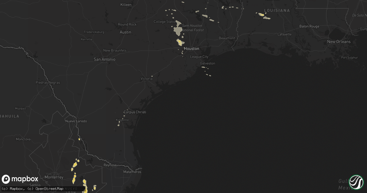
Hail Map on March 14, 2011
Get this storm
March 14 map
$229
one time, instant access
Download today. No call, no setup
Keep the $229
Bought the map and want the full workflow? Apply the entire $229 to a subscription within 7 days. None of it is wasted.
Every map, not just this one
This buys you this map. Subscription and you get every map we run, in the markets you choose from a few cities to whole states to nationwide. Plus real-time alerts the moment a storm fires.
Contact data
Name, contact info, occupancy, even credit band for addresses in the footprint. You go from where it hit to who to call.
Become the source they trust
Unlimited branding weather history reports on demand. You already have the documented answer ready for the property owner, and you are the one who showed up with it.
Property data and RoofTrace estimates
Pull up any address you have got, its value and the exact code rules for that jurisdiction, straight from One Click Code. Then RoofTrace estimates the squares, pitch, and roof value, priced the way you price.
Storm reports
Mississippi
| Date | Description |
|---|---|
| 03/14/20114:00 PM CDT | Three eyewitnesses observed a small tornado touchdown in a field...travel about 100 yards and take off the roof of a mobile home before lifting back up. Estimated path |
| 03/14/20113:55 PM CDT | Trees were downed at king rd and n hills st. |
| 03/14/20113:39 PM CDT | Tree down on power lines on griffis-fountain road. The lines came down from the impact. |
| 03/14/20113:10 PM CDT | A tree and utility lines were downed near lawrence |
| 03/14/20112:45 PM CDT | Utility lines were damaged near town of new hebron. |
| 03/14/20112:06 PM CDT | The tornado snapped and uprooted trees and caused roof damage to two barns along the 1.6 mile path. The tornado first touched down in the robinhood subdivision and trac |
| 03/14/20112:05 PM CDT | Numerous trees snapped with heights getting closer to the ground to the northwest. Portion of a roof peeled off to a small shed lying 75 yards to the northeast of the s |
| 03/14/20111:54 PM CDT | Trees down across highway 469. Report from florence police relayed through media. |
| 03/14/20111:52 PM CDT | Multiple large trees and limbs down in the magnolia springs subdivision |
| 03/14/20111:52 PM CDT | Trees and power lines down across highway 49.initially reported by ham radio and confirmed by florence police |
| 03/14/20111:40 PM CDT | A large tree was downed in the wrights mill subdivision |
| 03/14/201112:50 PM CDT | Large limbs down |
Alabama
| Date | Description |
|---|---|
| 03/14/20116:44 PM CDT | Tree fell on trailor. Winds estimated around 40 mph. |
| 03/14/20115:24 PM CDT | One tree down in roadway. Winds estimated around 40 mph. |
| 03/14/20115:24 PM CDT | Tree down on wires. Winds estimated around 40 |
| 03/14/20115:00 PM CDT | A few trees and power lines were blown down in northport. Winds were estimated around 40 mph. |
Cities Impacted by Hail Map on March 14, 2011
- Madisonville, TX
- Bedias, TX
- Richards, TX
- Montgomery, TX
- Anderson, TX
- Plantersville, TX
- Waller, TX
- Magnolia, TX
- Riviera, TX
- Richmond, TX
- Sugar Land, TX
- Oakdale, LA
- Normangee, TX
- Wiergate, TX
- Jasper, TX
- Cypress, TX
- Hockley, TX
- Katy, TX
- Crockett, TX
- Gilbert, LA
- Grant, LA
- Pitkin, LA
- Livingston, TX
- Mamou, LA
- Warren, TX
- Evans, LA
- Leesville, LA
- Brookeland, TX
- Trinity, TX
- Oberlin, LA
- Corrigan, TX
- Bryan, TX
- Sugartown, LA
- Deridder, LA
- Houston, TX
- Diboll, TX
- Iola, TX
- San Augustine, TX
- Kingsville, TX
- Bishop, TX
- Hearne, TX
- Inez, TX
- Galveston, TX
- Groveton, TX
- Robstown, TX
- Navasota, TX
- North Zulch, TX
- Pinehurst, TX
- Tomball, TX
- Colmesneil, TX