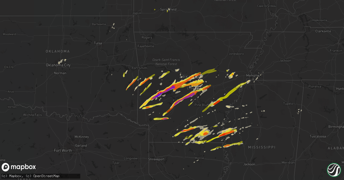
Hail Map on March 13, 2016
Get this storm
March 13 map
$229
one time, instant access
Download today. No call, no setup
Keep the $229
Bought the map and want the full workflow? Apply the entire $229 to a subscription within 7 days. None of it is wasted.
Every map, not just this one
This buys you this map. Subscription and you get every map we run, in the markets you choose from a few cities to whole states to nationwide. Plus real-time alerts the moment a storm fires.
Contact data
Name, contact info, occupancy, even credit band for addresses in the footprint. You go from where it hit to who to call.
Become the source they trust
Unlimited branding weather history reports on demand. You already have the documented answer ready for the property owner, and you are the one who showed up with it.
Property data and RoofTrace estimates
Pull up any address you have got, its value and the exact code rules for that jurisdiction, straight from One Click Code. Then RoofTrace estimates the squares, pitch, and roof value, priced the way you price.
States Impacted by Hail Map on March 13, 2016
Storm reports
Louisiana
| Date | Description |
|---|---|
| 03/12/20169:45 PM CST | Dime to quarter size hail reported. |
| 03/12/20166:42 PM CST | 1 inch hail reported in spearsville. |
Missouri
| Date | Description |
|---|---|
| 03/13/20165:20 PM CDT | Quarter size hail at weaver and scenic per broadcast media |
Mississippi
| Date | Description |
|---|---|
| 03/12/201610:56 PM CST | A local report indicates 1.00 inch wind near ANGUILLA |
| 03/12/201610:40 PM CST | Relayed via broadcast media. |
| 03/12/201610:30 PM CST | Quarter size hail reported in mayersville. |
| 03/12/20169:52 PM CST | Decent accumulation of hail along dycus road. Picture relayed by broadcast media shows mix of hail with quarter size largest. |
| 03/12/20169:48 PM CST | A local report indicates 1.75 inch wind near 2 S LELAND |
| 03/12/20169:33 PM CST | A local report indicates 1.00 inch wind near 3 S GREENVILLE |
| 03/12/20169:23 PM CST | Occurred at harlows casino near the ms river bridge. |
| 03/12/20169:13 PM CST | The tornado began along bishop rd and continued ne across w sunflower rd...ms hwy 8...and bolling ave before lifting at a delta st intercollegiate athletic facility. Se |
| 03/12/20169:12 PM CST | Part of the tin roof peeled off of no way joses...tin was thrown across the street. |
Virginia
| Date | Description |
|---|---|
| 03/12/20169:07 PM CST | Quarter sized hail lasted for five minutes |
Arkansas
| Date | Description |
|---|---|
| 03/13/20166:59 PM CDT | 1 inch hail reported just south of smackover. |
| 03/13/20166:56 PM CDT | A local report indicates 1.00 inch wind near 9 ESE EL DORADO |
| 03/13/20166:46 PM CDT | A local report indicates 1.75 inch wind near CONWAY |
| 03/13/20166:40 PM CDT | Golfball size hail covering the ground near greens chapel road. |
| 03/13/20166:37 PM CDT | 1 inch hail in the mount holly community. |
| 03/13/20166:35 PM CDT | 1 inch hail west of dierks |
| 03/13/20166:32 PM CDT | Three homes sustained roof damage and two homes sustained structural damage. |
| 03/13/20166:27 PM CDT | One house had roof damage and one end of the home was ripped off. |
| 03/13/20166:21 PM CDT | Trees and power lines were blown down near little italy...and roof of a church near wye was torn off. |
| 03/13/20166:05 PM CDT | A local report indicates 1.75 inch wind near WILLIAMS JUNCTION |
| 03/13/20166:01 PM CDT | Several trees were blown down on hwy 61 near scott...along with 2 mobile homes knocked off their foundations. |
| 03/13/20166:00 PM CDT | Trained spotter reports golfball sized hail around williams junction. |
| 03/13/20165:35 PM CDT | Two to three inch diameter hail was reported two miles north of jessieville. |
| 03/13/20165:25 PM CDT | Trained spotter reported golf ball sized hail east of bauxite. |
| 03/13/20165:22 PM CDT | Hail the size of quarters fell on interstate 30 between friendship and caddo valley. |
| 03/13/20165:15 PM CDT | Golfball sized hail was covering the road at the highway 35 and highway 190 junction. |
| 03/13/20165:07 PM CDT | Ping pong to tennis ball sized hail was falling in the buckville/avant area. |
| 03/13/20165:02 PM CDT | A local report indicates 1.50 inch wind near 2 SW PERLA |
| 03/13/20164:55 PM CDT | Trees have blown been blown down and docks ripped up at mountain harbor resort. |
| 03/13/20164:50 PM CDT | Ping pong size hail reported from amateur radio just outside of malvern city limits. |
| 03/13/20164:48 PM CDT | Quarter sized hail was falling and covering the ground. |
| 03/13/20164:45 PM CDT | Significant damage to several boat docks...trees...and power lines. Several homes damaged...including a mobile home with substantial damage. Path length 1.7 mi...width |
| 03/13/20164:45 PM CDT | A local report indicates 1.50 inch wind near MALVERN |
| 03/13/20164:40 PM CDT | A local report indicates 2.00 inch wind near FRIENDSHIP |
| 03/13/20164:30 PM CDT | Baseball sized hail reported by montgomery county sheriffs office. |
| 03/13/20164:22 PM CDT | Hail the size of quarters fell on interstate 30 between friendship and caddo valley. |
| 03/13/20164:02 PM CDT | Half a dozen pine trees were knocked down...as well as some large tree limbs. |
| 03/13/20163:56 PM CDT | Tornado uprooted trees and caused damage to several buildings. Path length 4.4 mi...max width 850 yds...max wind 86 to 110 mph. |
| 03/13/20163:45 PM CDT | Golf ball sized hail reported by fire department in lake hinkle. |
| 03/13/20163:44 PM CDT | 7-8 houses were damaged near winfield. |
| 03/13/20163:43 PM CDT | Spotted brief rope tornado |
| 03/13/20163:42 PM CDT | Public reports 1 inch size hail covering the ground west of mena. Mping |
| 03/13/20163:40 PM CDT | Reported by park superintendent at cossatot river state park natural area. |
| 03/13/20163:25 PM CDT | Quarter size hail reported on lake rd...northeast of gillham. |
| 03/13/20163:22 PM CDT | In the city |
| 03/13/20163:20 PM CDT | Reported by park superintendent at cossatot river state park natural area. |
| 03/12/20169:11 PM CST | Penny to quarter size hail reported along hwy 82 by the lake. |
| 03/12/20168:27 PM CST | A roof of a church was blown off. |
| 03/12/20168:22 PM CST | Continuation of tornado from chicot county ar. Crossed into desha county where it snapped and uprooted trees and downed power lines. Path length inside desha county 2.6 |
| 03/12/20168:20 PM CST | A local report indicates 1.00 inch wind near DERMOTT |
| 03/12/20168:18 PM CST | Possible tornado. Scattered damage near the intersection of south trotter and rosehill. Numerous trees uprooted and snapped. Juvenile dentention camp fencing destroyed. |
| 03/12/20168:15 PM CST | *** 1 inj *** tornado began in sw dermott near buckner ln... Continued across trotter st and us hwy 165 before hitting detla regional correctional facility where an emplo (ja |
| 03/12/20168:10 PM CST | An ef-1 tornado touched down for about 5 minutes causing damage to a house...a few outbuildings...and an airplane hangar. |
| 03/12/20167:45 PM CST | A local report indicates 1.00 inch wind near 6 S CROSSETT |
| 03/12/20167:35 PM CST | Trees were blown down. |
| 03/12/20167:30 PM CST | Cone shaped tornado crossed highway 1 near lexa and cypress juntion. Power flashes and power lines down. |
| 03/12/20167:30 PM CST | Ping pong size hail on hwy 284. |
| 03/12/20167:23 PM CST | Quarter size hail reported in and around fountain hill. |
| 03/12/20167:20 PM CST | Quarter to half dollar sized hail observed just south of cabot. |
| 03/12/20167:15 PM CST | Golf ball size hail damaged cars as well as some homes. |
| 03/12/20167:15 PM CST | A local report indicates 1.00 inch wind near JACKSONVILLE |
| 03/12/20167:13 PM CST | 1 inch hail reported in the lawson community. |
| 03/12/20167:13 PM CST | Hail slightly larger than golfball reported just southwest of prescott. |
| 03/12/20167:10 PM CST | 1 inch hail in the strong community. |
| 03/12/20167:05 PM CST | Trained spotters report tornado at intersection of us hwy 49 and arkansas hwy 1 in west section of marvell. |
| 03/12/20167:05 PM CST | A local report indicates 1.00 inch wind near SEARCY |
| 03/12/20167:05 PM CST | 1 inch hail reported in strong... Arkansas |
| 03/12/20166:57 PM CST | A local report indicates 1.50 inch wind near SHERWOOD |
| 03/12/20166:57 PM CST | A local report indicates 1.50 inch wind near N LITTLE ROCK ARPT |
| 03/12/20166:57 PM CST | Ping pong ball sized hail was falling at gibson. |
| 03/12/20166:55 PM CST | 1 inch hail reported east southeast of el dorado. |
| 03/12/20166:48 PM CST | A tree was blown down across highway 49. |
| 03/12/20166:35 PM CST | A local report indicates 1.00 inch wind near MAUMELLE |
| 03/12/20166:30 PM CST | A combine was flipped over on sam deberry road. |
| 03/12/20166:20 PM CST | A local report indicates 1.00 inch wind near HAMPTON |
| 03/12/20166:15 PM CST | Rope tornado reported in the new london community |
| 03/12/20166:09 PM CST | Power lines were blown down near de witt. |
| 03/12/20166:00 PM CST | 2 inch hail reported in smackover |
Oklahoma
| Date | Description |
|---|---|
| 03/13/20163:35 PM CDT | Social media report with picture |
North Carolina
| Date | Description |
|---|---|
| 03/12/20167:54 PM CST | Tree down on glenwood avenue near the durham county line |
| 03/12/20166:35 PM CST | Hail near the size of ping pong balls. |
Alabama
| Date | Description |
|---|---|
| 03/13/20166:15 AM CDT | Powerlines reported down. |
Oregon
| Date | Description |
|---|---|
| 03/13/20164:30 PM CDT | Tree downed by winds blocked sw barnes rd |
Cities Impacted by Hail Map on March 13, 2016
- Dodson, LA
- Jonesboro, LA
- Jones, OK
- Luther, OK
- Mineral Springs, AR
- Crumrod, AR
- Mellwood, AR
- Louisburg, NC
- Warren, AR
- Leland, MS
- Dierks, AR
- Gillham, AR
- Umpire, AR
- Whitakers, NC
- Scotland Neck, NC
- Keota, OK
- Bokoshe, OK
- Norman, AR
- Caddo Gap, AR
- Youngsville, NC
- Stuttgart, AR
- Wake Forest, NC
- Zebulon, NC
- Memphis, TN
- Bauxite, AR
- Mabelvale, AR
- Benton, AR
- Hollandale, MS
- Inverness, MS
- Lake Village, AR
- Portland, AR
- Parkdale, AR
- Wilmot, AR
- Greenville, MS
- Indianola, MS
- Eudora, AR
- Prescott, AR
- Atkins, AR
- Russellville, AR
- Emmet, AR
- Holly Grove, AR
- Rolesville, NC
- Franklinton, NC
- Oxford, NC
- Kittrell, NC
- Smackover, AR
- Louann, AR
- Conway, AR
- Perryville, AR
- Plainview, AR
- Mayflower, AR
- Sherwood, AR
- Cabot, AR
- Donaldson, AR
- Bismarck, AR
- Jessieville, AR
- Mount Ida, AR
- Maumelle, AR
- Friendship, AR
- Vilonia, AR
- Little Rock Air Force Base, AR
- El Paso, AR
- Malvern, AR
- Bigelow, AR
- North Little Rock, AR
- Sims, AR
- De Queen, AR
- Romance, AR
- Jacksonville, AR
- Ward, AR
- Hensley, AR
- Story, AR
- Enola, AR
- Lonoke, AR
- England, AR
- Keo, AR
- Roland, AR
- Mount Vernon, AR
- Hot Springs Village, AR
- Traskwood, AR
- Houston, AR
- Arkadelphia, AR
- Greenbrier, AR
- Grannis, AR
- Sheridan, AR
- Searcy, AR
- Scott, AR
- Austin, AR
- Paron, AR
- Alexander, AR
- Mena, AR
- Carlisle, AR
- Little Rock, AR
- Beebe, AR
- Magnolia, AR
- Battleboro, NC
- Detroit, AL
- Star City, AR
- Yazoo City, MS
- Rolling Fork, MS
- Louise, MS
- Anguilla, MS
- Lake Providence, LA
- Mayersville, MS
- Clarksdale, MS
- Gould, AR
- Hamburg, AR
- Hermitage, AR
- Crossett, AR
- Fountain Hill, AR
- Monticello, AR
- Wilmar, AR
- Greenwood, MS
- Itta Bena, MS
- Hughes, AR
- Robinsonville, MS
- Brickeys, AR
- Booneville, AR
- Spearsville, LA
- Chatham, VA
- Rocky Mount, NC
- Tarboro, NC
- Lake Cormorant, MS
- Waldron, AR
- Boles, AR
- De Witt, AR
- Almyra, AR
- Crocketts Bluff, AR
- Altheimer, AR
- Grady, AR
- Humphrey, AR
- Hampton, AR
- Banks, AR
- Belzoni, MS
- Wynne, AR
- Forrest City, AR
- Lambert, MS
- Huttig, AR
- Snow Lake, AR
- Alligator, MS
- Ahoskie, NC
- Aulander, NC
- Windsor, NC
- Colerain, NC
- Durant, MS
- Oak Grove, LA
- Oklahoma City, OK
- Edmond, OK
- Charleston, MS
- Parks, AR
- Chelsea, OK
- Morrisville, NC
- Raleigh, NC
- Colt, AR
- Smithville, MS
- Greenwood Springs, MS
- Morrilton, AR
- Perry, AR
- Mccurtain, OK
- Belleville, AR
- Dardanelle, AR
- Havana, AR
- Coffeeville, MS
- Water Valley, MS
- Fulton, AR
- Washington, AR
- Columbus, AR
- Briggsville, AR
- Bluffton, AR
- Amory, MS
- El Dorado, AR
- Mount Holly, AR
- Cary, NC
- Durham, NC
- Dermott, AR
- Moorhead, MS
- Spring Hope, NC
- Creedmoor, NC
- Wendell, NC
- Bunn, NC
- Mansfield, AR
- Jersey, AR
- Nashville, AR
- Lockesburg, AR
- Hope, AR
- Montrose, AR
- West Monroe, LA
- Eros, LA
- Callands, VA
- Penhook, VA
- Minter City, MS
- Chapel Hill, NC
- Quinton, OK
- Palestine, AR
- Castalia, NC
- Knightdale, NC
- New Edinburg, AR
- Walls, MS
- Heavener, OK
- Howe, OK
- Talihina, OK
- Poteau, OK
- Hodgen, OK
- Whitesboro, OK
- Murfreesboro, AR
- Kirby, AR
- Amity, AR
- Hobgood, NC
- Pencil Bluff, AR
- Augusta, AR
- Thornton, AR
- Ozan, AR
- Saratoga, AR
- Ruleville, MS
- Drew, MS
- Cotton Plant, AR
- McCrory, AR
- Glenwood, AR
- Hot Springs National Park, AR
- Lonsdale, AR
- Springfield, MO
- Vinita, OK
- Pottsville, AR
- Eads, TN
- Arlington, TN
- Cordova, TN
- McGehee, AR
- Hartford, AR
- Rohwer, AR
- Henderson, NC
- Arcadia, OK
- Hatfield, AR
- Lyon, MS
- Marianna, AR
- Strong, AR
- Lillie, LA
- Junction City, AR
- Hickory Ridge, AR
- Southaven, MS
- Bastrop, LA
- Collinston, LA
- Benoit, MS
- Chatham, MS
- Glen Allan, MS
- Mer Rouge, LA
- Cleveland, MS
- Okolona, AR
- Blevins, AR
- Redfield, AR
- Arkansas City, AR
- Marion, LA
- Paris, AR
- Subiaco, AR
- Siler City, NC
- Ramseur, NC
- Staley, NC
- Pioneer, LA
- Silver City, MS
- Miller, MO
- Poplar Grove, AR
- Marvell, AR
- Clarendon, AR
- Lexa, AR
- Aubrey, AR
- Cameron, OK
- Newhope, AR
- Delaware, AR
- Magazine, AR
- Hazen, AR
- Pine Bluff, AR
- Yorktown, AR
- McRae, AR
- Kensett, AR
- Bald Knob, AR
- Judsonia, AR