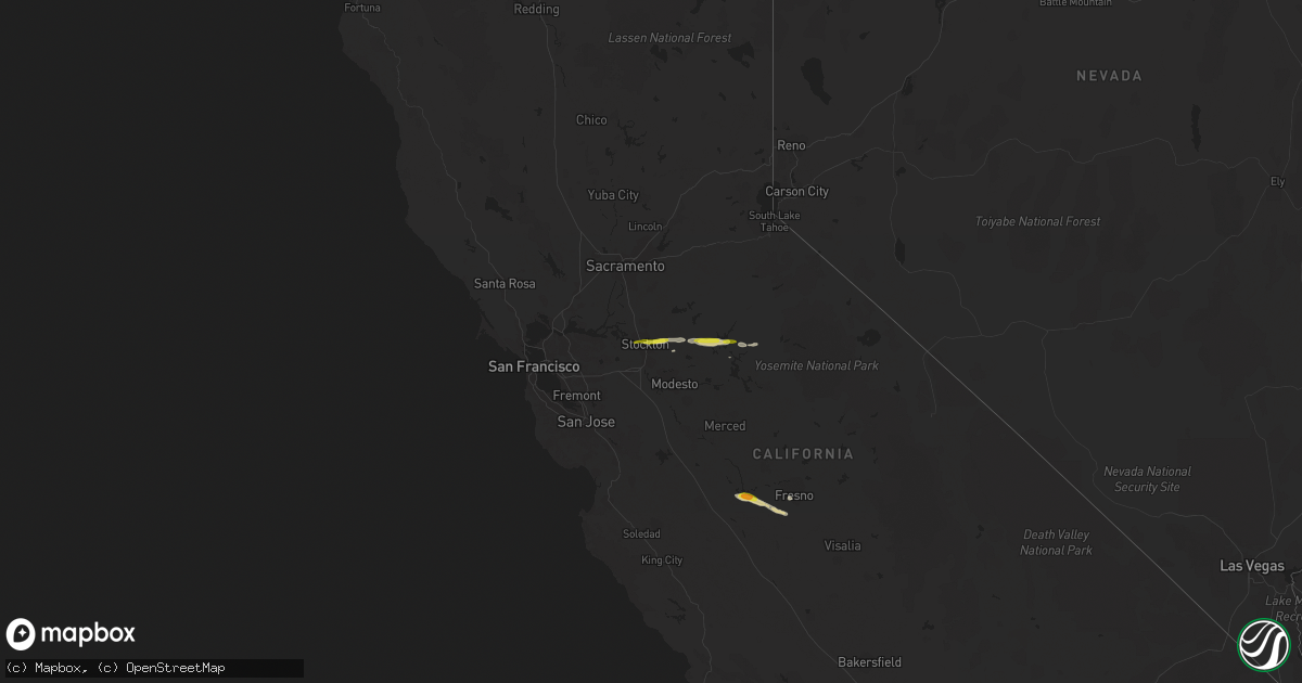
Hail Map on March 11, 2023
Get this storm
March 11 map
$229
one time, instant access
Download today. No call, no setup
Keep the $229
Bought the map and want the full workflow? Apply the entire $229 to a subscription within 7 days. None of it is wasted.
Every map, not just this one
This buys you this map. Subscription and you get every map we run, in the markets you choose from a few cities to whole states to nationwide. Plus real-time alerts the moment a storm fires.
Contact data
Name, contact info, occupancy, even credit band for addresses in the footprint. You go from where it hit to who to call.
Become the source they trust
Unlimited branding weather history reports on demand. You already have the documented answer ready for the property owner, and you are the one who showed up with it.
Property data and RoofTrace estimates
Pull up any address you have got, its value and the exact code rules for that jurisdiction, straight from One Click Code. Then RoofTrace estimates the squares, pitch, and roof value, priced the way you price.
States Impacted by Hail Map on March 11, 2023
Storm reports
California
| Date | Description |
|---|---|
| 03/11/20235:43 PM CST | Social media report of 1 inch hail on twitter. |
| 03/11/20235:00 PM CST | A storm spotter reported 1 inch hail downtown sonora. They also said the creek downtown has reached its banks. |
| 03/11/20233:01 PM CST | Public reported hail up to quarter size along highway 26 near beyer lane. Photos confirmed. Time estimated by radar. |
| 03/11/20232:42 PM CST | Report of hail with hail stones up to quarter size in stockton. Time estimated from radar. |
Louisiana
| Date | Description |
|---|---|
| 03/11/20235:53 AM CST | A local report indicates 1.00 inch wind near SICILY ISLAND |
Mississippi
| Date | Description |
|---|---|
| 03/11/20233:10 AM CST | Scattered trees down in the ne/e side of the county. Cr 614... A tree damaged the corner of a home. Hwy 16e and cr 602... Trees across the road. |
| 03/11/20233:00 AM CST | A couple trees down in the nw part of the county... Along hwy 19n. |
| 03/11/20232:57 AM CST | Large pine tree down across cr 122... Event occurred around 757z. |
| 03/11/20232:57 AM CST | A few trees down along hwy 17 n. |
| 03/11/20232:55 AM CST | Corrects previous tstm wnd dmg report from 3 se coxburg. A few trees down along hwy 433 near the county line. Event occurred at 755z. |
| 03/11/20232:53 AM CST | Several trees downed in the arlington area... Including along cr 602. Trees fell on two houses along cr 602. A metal carport roof was blown onto a car along cr 802. One |
| 03/11/20232:53 AM CST | A couple trees down alon hwy 35s... Event occurred around 853z. |
| 03/11/20232:47 AM CST | A few trees down along remus rd and hwy 25 n. Event occurred around 847z. |
| 03/11/20232:40 AM CST | A few trees down along hwy 35n... Event was around 840z. |
| 03/11/20232:30 AM CST | Several trees down in the ne part of the county. Some down on the trace... Hwy 43 s and hwy 429 near st. Anne rd. Event occurred around 830z. |
| 03/11/20232:30 AM CST | A lot of nickel to quarter sized hail... Event occurred at 730z. |
| 03/11/20232:19 AM CST | 2 pines down across doris rd. |
| 03/11/20232:10 AM CST | A couple trees down along i-55... Event occurred around 810z. |
| 03/11/20232:10 AM CST | Awning damaged at the circle k along hwy 82. |
| 03/11/202312:55 AM CST | A few trees down along hwy 433 near the county line. |
| 03/11/202312:40 AM CST | Tree down along wilcox road near hwy 82. |
| 03/11/202312:20 AM CST | Trees down in the area... Event occurred around 620z. |
Arkansas
| Date | Description |
|---|---|
| 03/11/202312:30 AM CST | Corrects previous hail report from 1 nw lake village. Golf ball sized hail reported by the sheriffs office. |
| 03/11/202312:03 AM CST | Parapet wall on a building was blown over. Reported by em. |
| 03/10/202311:30 PM CST | Golf ball sized hail reported by the sheriffs office. |
| 03/10/202310:44 PM CST | Reported via nws chat. |
| 03/10/202310:43 PM CST | A local report indicates 1.00 inch wind near CHENAL VALLEY |
| 03/10/202310:43 PM CST | A local report indicates 1.25 inch wind near TIMBER RIDGE |
| 03/10/20239:35 PM CST | Downed tree in westbound lane/shoulder of hwy 70 north of lockesburg. |
| 03/10/20239:33 PM CST | From trained spotter east of de queen via spotternetwork.org. |
| 03/10/20239:29 PM CST | A local report indicates 1.75 inch wind near GRAVELLY |
| 03/10/20239:10 PM CST | A local report indicates 1.00 inch wind near 1 NNW CADDO GAP |
Oklahoma
| Date | Description |
|---|---|
| 03/10/20239:57 PM CST | Social media picture of hail near quarter size just north of the eagletown community. |
| 03/10/20239:45 PM CST | Reported around broken bow reservoir in the hochatown area. |
| 03/10/20239:40 PM CST | Near the intersection of us hwy 259 and state hwy 259 a. |
| 03/10/20239:33 PM CST | Reported in the hochatown area. |
Cities Impacted by Hail Map on March 11, 2023
- Stockton, CA
- Linden, CA
- Copperopolis, CA
- Angels Camp, CA
- Jamestown, CA
- Sonora, CA
- Mendota, CA
- Tranquillity, CA
- Kerman, CA
- Snow, OK
- Nashoba, OK
- Hodgen, OK
- Heavener, OK
- Rattan, OK
- Mena, AR
- Boles, AR
- Caruthers, CA
- Fresno, CA
- Raisin City, CA
- Clayton, OK
- Hatfield, AR
- Tuolumne, CA
- Farmington, CA
- Watson, OK
- Smithville, OK
- Honobia, OK
- Whitesboro, OK
- Broken Bow, OK
- Bethel, OK
- Antlers, OK
- Mi Wuk Village, CA
- Norman, AR
- Valliant, OK
- Ringold, OK
- Caddo Gap, AR
- Glenwood, AR
- Bonnerdale, AR
- Parks, AR
- Waldron, AR
- Eagletown, OK
- De Queen, AR
- Gillham, AR
- Lockesburg, AR
- Nashville, AR
- Harvey, AR
- Gravelly, AR
- Bluffton, AR
- Briggsville, AR
- Ozan, AR
- Beebe, AR
- McRae, AR
- McCaskill, AR
- Hope, AR
- Blevins, AR
- Emmet, AR
- Prescott, AR
- Rosston, AR
- Washington, AR
- Fulton, AR
- Hermitage, AR
- Fountain Hill, AR
- Wilmar, AR
- Monticello, AR
- Hamburg, AR
- Dermott, AR
- Montrose, AR
- Lake Village, AR
- Wickes, AR
- Amity, AR
- El Dorado, AR
- Bigelow, AR
- Kirby, AR
- Mount Ida, AR
- Beulah, MS
- North Little Rock, AR
- Plainview, AR
- Delight, AR
- Gurdon, AR
- Langley, AR
- Newhope, AR
- Grannis, AR
- Hot Springs National Park, AR
- Malvern, AR
- Murfreesboro, AR
- Donaldson, AR
- Bismarck, AR
- Okolona, AR
- Benoit, MS
- Shaw, MS
- Antoine, AR
- Horatio, AR
- Roland, AR
- Little Rock, AR
- Chidester, AR
- Mineral Springs, AR
- Camden, AR
- Maumelle, AR
- Boyle, MS
- Hampton, AR
- Cove, AR
- Kilmichael, MS
- Duck Hill, MS
- Saratoga, AR
- Dierks, AR
- Columbus, AR
- Moyers, OK
- Minden, LA
- Homer, LA
- Eudora, AR
- Bienville, LA
- Mayflower, AR
- Bearden, AR
- Winthrop, AR
- Marshall, TX
- Arkadelphia, AR
- Isola, MS
- Belzoni, MS
- Eros, LA
- Ruston, LA
- Choudrant, LA
- Calhoun, LA
- Anguilla, MS
- Louise, MS
- Rohwer, AR
- Schlater, MS
- Ruleville, MS
- Greenwood, MS
- Doddsville, MS
- Cleveland, MS
- West Monroe, LA
- Paron, AR
- Goodman, MS
- Sallis, MS
- Pickens, MS
- Lexington, MS
- Jonesboro, LA
- Chatham, LA
- Quitman, LA
- Sikes, LA
- Greenville, MS
- Durant, MS
- Yazoo City, MS
- Silver City, MS
- Camden, MS
- Inverness, MS
- Tchula, MS
- Hollandale, MS
- Elm Grove, LA
- Bossier City, LA
- Bluff City, AR
- Columbia, LA
- Dodson, LA
- Grayson, LA
- Kelly, LA
- McCarley, MS
- Winona, MS
- Junction City, AR
- Cruger, MS
- Greenwood, LA
- Shreveport, LA
- Waskom, TX
- De Berry, TX
- Bethany, LA
- Mooringsport, LA
- Stewart, MS
- Rolling Fork, MS
- Mayersville, MS
- Glen Allan, MS
- Portland, AR
- Parkdale, AR
- Simsboro, LA
- Pearcy, AR
- Umpire, AR
- Thornton, AR
- Leland, MS
- Kosciusko, MS
- Muse, OK
- Winnsboro, LA
- Gilbert, LA
- Newellton, LA
- Saint Joseph, LA
- Clayton, LA
- Wisner, LA
- Sicily Island, LA
- Fort Necessity, LA
- Harrisonburg, LA
- Lorman, MS
- Waterproof, LA