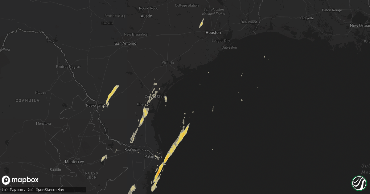
Hail Map on March 9, 2016
Get this storm
March 9 map
$229
one time, instant access
Download today. No call, no setup
Keep the $229
Bought the map and want the full workflow? Apply the entire $229 to a subscription within 7 days. None of it is wasted.
Every map, not just this one
This buys you this map. Subscription and you get every map we run, in the markets you choose from a few cities to whole states to nationwide. Plus real-time alerts the moment a storm fires.
Contact data
Name, contact info, occupancy, even credit band for addresses in the footprint. You go from where it hit to who to call.
Become the source they trust
Unlimited branding weather history reports on demand. You already have the documented answer ready for the property owner, and you are the one who showed up with it.
Property data and RoofTrace estimates
Pull up any address you have got, its value and the exact code rules for that jurisdiction, straight from One Click Code. Then RoofTrace estimates the squares, pitch, and roof value, priced the way you price.
States Impacted by Hail Map on March 9, 2016
Storm reports
Louisiana
| Date | Description |
|---|---|
| 03/09/20169:19 AM CST | Multiple trees uprooted to saturated soils...winds were estimated to be 35 mph. |
Texas
| Date | Description |
|---|---|
| 03/09/20169:05 AM CST | Large/healthy trees down on road near nimitz and rosebud |
| 03/09/20168:18 AM CST | Roof damage to home along rattlesnake point rd. |
| 03/09/20168:10 AM CST | Refugio law enforecment reported wind damage to a barn in the bonnie view area. Rancher estimated winds of 60 to 70 mph. |
| 03/09/20168:09 AM CST | Large tree blown onto mobile home on leary lane...causing damage to mobile home |
| 03/09/20168:05 AM CST | Large/healthy trees down on road near nimitz and rosebud |
| 03/09/20168:05 AM CST | Multiple trees down near the norwood community |
| 03/09/20167:59 AM CST | Video of large tree blown onto house near 1069 in ingleside. Time estimated from radar. |
| 03/09/20167:55 AM CST | Trees downed/uprooted in gregory |
| 03/09/20167:18 AM CST | Roof damage to home along rattlesnake point rd. |
| 03/09/20167:10 AM CST | Refugio law enforecment reported wind damage to a barn in the bonnie view area. Rancher estimated winds of 60 to 70 mph. |
| 03/09/20166:59 AM CST | Video of large tree blown onto house near 1069 in ingleside. Time estimated from radar. |
| 03/09/20166:55 AM CST | Trees downed/uprooted in gregory |
| 03/09/20166:50 AM CST | Power poles and lines down along highway 107. Trees down near brewster elementary |
Cities Impacted by Hail Map on March 9, 2016
- Cypress, TX
- Tomball, TX
- Hockley, TX
- Riviera, TX
- Kingsville, TX
- Sarita, TX
- Magnolia, TX
- Corpus Christi, TX
- Laredo, TX
- Mcallen, TX
- Mission, TX
- Freer, TX
- Tilden, TX
- Brownsville, TX
- Armstrong, TX
- Edinburg, TX
- Taft, TX
- Sinton, TX
- Robstown, TX
- San Ygnacio, TX
- Encinal, TX
- Goliad, TX
- Huntsville, TX
- Trinity, TX
- Portland, TX
- Bishop, TX
- Port Isabel, TX
- Pinehurst, TX
- Katy, TX
- Encino, TX
- Linn, TX
- Woodsboro, TX