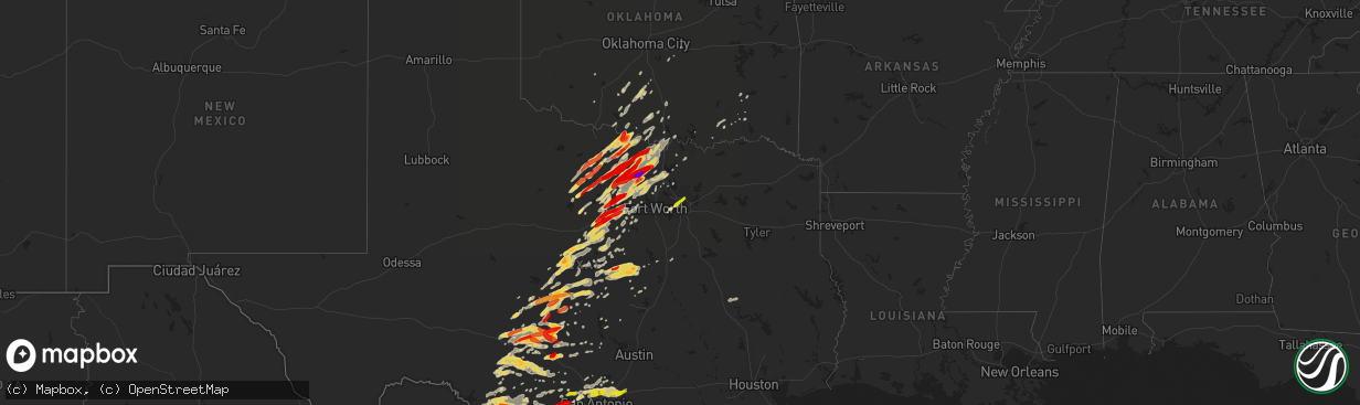
Hail Map on March 9, 2013
The weather event on March 9, 2013 includes Hail map. 2 states and 227 cities were impacted and suffered possible damage. The total estimated number of properties impacted is 161,119.
Want more than just the map?
Turn this storm into a full workflow.
- Owner + property data so you know who to knock
- OnDemand branded weather history reports to win the "did we even have hail?" argument
- RoofTrace estimate so reps stop guessing numbers at the door
Bought this map? Upgrade within 7 days and we'll credit the $230. (10-15 min setup call)
Hail
161,119
Estimated number of impacted properties by a 1.00" hail or larger96,785
Estimated number of impacted properties by a 1.75" hail or larger1,512
Estimated number of impacted properties by a 2.50" hail or largerStorm reports
Oklahoma
| Date | Description |
|---|---|
| 03/09/20134:24 PM CST | A local report indicates 1.00 inch wind near THACKERVILLE |
| 03/09/20134:24 PM CST | A local report indicates 1.00 inch wind near MARIETTA |
| 03/09/20133:24 PM CST | A local report indicates 1.00 inch wind near THACKERVILLE |
| 03/09/20133:24 PM CST | A local report indicates 1.00 inch wind near MARIETTA |
| 03/09/20133:14 PM CST | A local report indicates 2.50 inch wind near 4 N TERRAL |
| 03/09/20132:14 PM CST | A local report indicates 2.50 inch wind near 4 N TERRAL |
| 03/09/20131:56 PM CST | A local report indicates 63 MPH wind near 4 ENE NORMAN |
| 03/09/20131:50 PM CST | 10-12 inch diameter tree limbs down at 48th and robinson |
| 03/09/20131:35 PM CST | A local report indicates 1.00 inch wind near 3 N COMANCHE |
| 03/08/20138:38 PM CST | A local report indicates 1.00 inch wind near 3 N COMANCHE |
Texas
| Date | Description |
|---|---|
| 03/09/20135:20 PM CST | A local report indicates 1.00 inch wind near 7 SW MAY |
| 03/09/20135:16 PM CST | A local report indicates 1.00 inch wind near ROSSTON |
| 03/09/20135:13 PM CST | Quarter size hail reported in paradise. |
| 03/09/20135:10 PM CST | A local report indicates 1.75 inch wind near 12 NW BROWNWOOD |
| 03/09/20134:54 PM CST | Measured between 2.75 and 3.00 inch hail at 287 rest stop north of decatur. |
| 03/09/20134:52 PM CST | Two inch diameter hail measured at a 287 rest stop north of decatur. |
| 03/09/20134:49 PM CST | Golfball sized hail reported 287 rest stop north of decatur. |
| 03/09/20134:48 PM CST | A local report indicates 1.00 inch wind near 2 N MUENSTER |
| 03/09/20134:46 PM CST | Pea size hail...with some hailstones to half dollar size...occurred over a 30 min duration. Hail accumulated to a 4 inch depth. |
| 03/09/20134:45 PM CST | A local report indicates 1.25 inch wind near 2 E THRIFTY |
| 03/09/20134:40 PM CST | A local report indicates 1.00 inch wind near 1 N MINERAL WELLS |
| 03/09/20134:34 PM CST | At the allsups in bridgeport |
| 03/09/20134:26 PM CST | 1 n alvord |
| 03/09/20134:18 PM CST | A local report indicates 1.00 inch wind near 2 NNW ALVORD |
| 03/09/20134:16 PM CST | A local report indicates 1.00 inch wind near ROSSTON |
| 03/09/20134:09 PM CST | 3 n chico |
| 03/09/20134:07 PM CST | A local report indicates 1.75 inch wind near ALVORD |
| 03/09/20134:07 PM CST | One inch hail 4 n alvord |
| 03/09/20133:54 PM CST | Measured between 2.75 and 3.00 inch hail at 287 rest stop north of decatur. |
| 03/09/20133:52 PM CST | Two inch diameter hail measured at a 287 rest stop north of decatur. |
| 03/09/20133:51 PM CST | A local report indicates 1.50 inch wind near 5 SE BOWIE |
| 03/09/20133:49 PM CST | Golfball sized hail reported 287 rest stop north of decatur. |
| 03/09/20133:48 PM CST | A local report indicates 1.00 inch wind near 2 N MUENSTER |
| 03/09/20133:41 PM CST | A local report indicates 1.00 inch wind near 3 S BOWIE |
| 03/09/20133:40 PM CST | A local report indicates 1.00 inch wind near 1 N MINERAL WELLS |
| 03/09/20133:34 PM CST | At the allsups in bridgeport |
| 03/09/20133:34 PM CST | Quarter hail 4 w nocona reported by media spotter |
| 03/09/20133:26 PM CST | 1 n alvord |
| 03/09/20133:22 PM CST | Quarter to golf ball size hail 9 nne of jackboro |
| 03/09/20133:18 PM CST | A local report indicates 1.00 inch wind near 2 NNW ALVORD |
| 03/09/20133:09 PM CST | 3 n chico |
| 03/09/20133:09 PM CST | Covering the ground |
| 03/09/20133:07 PM CST | A local report indicates 1.75 inch wind near ALVORD |
| 03/09/20133:07 PM CST | A local report indicates 1.75 inch wind near 4 N ALVORD |
| 03/09/20133:02 PM CST | A local report indicates 1.75 inch wind near 3 N JACKSBORO |
| 03/09/20132:51 PM CST | A local report indicates 1.50 inch wind near 5 SE BOWIE |
| 03/09/20132:41 PM CST | A local report indicates 1.00 inch wind near 3 S BOWIE |
| 03/09/20132:35 PM CST | A local report indicates 1.25 inch wind near 1 W WINDTHORST |
| 03/09/20132:34 PM CST | Quarter hail 4 w nocona reported by media spotter |
| 03/09/20132:22 PM CST | Quarter to golf ball size hail 9 nne of jackboro |
| 03/09/20132:09 PM CST | Covering the ground |
| 03/09/20132:02 PM CST | A local report indicates 1.75 inch wind near 3 N JACKSBORO |
| 03/09/20131:35 PM CST | A local report indicates 1.25 inch wind near 1 W WINDTHORST |
| 03/09/20138:45 AM CST | A local report indicates 1.50 inch wind near 12 ENE ROCKSPRINGS |
| 03/09/20131:18 AM CST | Hail inch and a quarter size and wind gusts to 44 mph. |
| 03/09/20131:09 AM CST | Penny to quarter size hail |
| 03/09/201312:56 AM CST | Dime to quarter size hail |
| 03/09/201312:30 AM CST | Pea to quarter size hail |
| 03/09/201312:30 AM CST | Nickel to quarter size hail |
| 03/09/201312:18 AM CST | Hail inch and a quarter size and wind gusts to 44 mph. |
| 03/09/201312:09 AM CST | Penny to quarter size hail |
| 03/08/201311:51 PM CST | Dime to quarter size hail |
| 03/08/201311:40 PM CST | Nickel to quarter size hail |
| 03/08/201311:30 PM CST | Pea to quarter size hail |
| 03/08/201311:26 PM CST | Marble to quarter size hail |
| 03/08/201310:51 PM CST | Dime to quarter size hail |
| 03/08/201310:26 PM CST | Marble to quarter size hail |
| 03/08/201310:03 PM CST | Northwest highway and dallas north tollway |
| 03/08/20139:50 PM CST | 2 miles se of kdal |
| 03/08/20139:20 PM CST | A local report indicates 1.25 inch wind near 10 NNE ROCKSPRINGS |
| 03/08/20139:03 PM CST | Northwest highway and dallas north tollway |
| 03/08/20139:00 PM CST | A local report indicates 1.00 inch wind near JUNCTION |
| 03/08/20138:50 PM CST | 2 miles se of kdal |
| 03/08/20138:45 PM CST | A local report indicates 1.50 inch wind near 18 SW MASON |
| 03/08/20138:45 PM CST | A local report indicates 1.50 inch wind near 12 ENE ROCKSPRINGS |
| 03/08/20138:30 PM CST | Golfball size hail. |
| 03/08/20138:30 PM CST | A local report indicates 1.75 inch wind near JUNCTION |
| 03/08/20138:13 PM CST | A local report indicates 1.75 inch wind near 25 W SAN SABA |
| 03/08/20138:00 PM CST | A local report indicates 1.00 inch wind near 10 NE SAN SABA |
| 03/08/20137:59 PM CST | Hail a little larger than golf balls. |
| 03/08/20137:43 PM CST | Thunderstorm winds caused a roof collapse of a supermarket in the city. Unknown if there are injuries at this time. Several trees downed in the city. |
| 03/08/20137:35 PM CST | A local report indicates 1.00 inch wind near 3 SSE BRADY |
| 03/08/20137:35 PM CST | A local report indicates 1.75 inch wind near 16 SW MASON |
| 03/08/20137:30 PM CST | A local report indicates 1.00 inch wind near 3 S LONDON |
| 03/08/20137:21 PM CST | A local report indicates 1.00 inch wind near BRADY |
| 03/08/20137:20 PM CST | A local report indicates 1.00 inch wind near 1 SW BRADY |
| 03/08/20137:20 PM CST | A local report indicates 1.00 inch wind near 3 NNE BRADY |
| 03/08/20137:19 PM CST | Golfball size hail |
| 03/08/20137:19 PM CST | A local report indicates 1.00 inch wind near 5 W BRADY |
| 03/08/20137:17 PM CST | A local report indicates 1.25 inch wind near BRADY |
| 03/08/20137:03 PM CST | Quarter sized hail in hudson oaks area. |
| 03/08/20136:50 PM CST | A local report indicates 1.00 inch wind near 1 N JUNCTION |
| 03/08/20136:43 PM CST | Thunderstorm winds caused a roof collapse of a supermarket in the city. Unknown if there are injuries at this time. Several trees downed in the city. |
| 03/08/20136:40 PM CST | A local report indicates 1.00 inch wind near 1 N JUNCTION |
| 03/08/20136:25 PM CST | A local report indicates 1.75 inch wind near ROCHELLE |
| 03/08/20136:25 PM CST | A local report indicates 1.00 inch wind near 12 NE BRADY |
| 03/08/20136:25 PM CST | A local report indicates 60 MPH wind near 12 NE BRADY |
| 03/08/20136:19 PM CST | Golfball size hail |
| 03/08/20136:15 PM CST | A local report indicates 1.00 inch wind near 3 NW BRADY |
| 03/08/20136:03 PM CST | Quarter sized hail in hudson oaks area. |
Cities Impacted by Hail Map on March 9, 2013
- Carbon, TX
- Rhome, TX
- Boyd, TX
- Decatur, TX
- Weatherford, TX
- Brownwood, TX
- Menard, TX
- Cherokee, TX
- Ryan, OK
- Terral, OK
- Nocona, TX
- Henrietta, TX
- Ringgold, TX
- Comanche, TX
- San Antonio, TX
- Mason, TX
- Junction, TX
- London, TX
- Rocksprings, TX
- Uvalde, TX
- Cranfills Gap, TX
- Clifton, TX
- Jacksboro, TX
- Blanchard, OK
- Gatesville, TX
- Hext, TX
- Sabinal, TX
- D Hanis, TX
- Hondo, TX
- Byers, TX
- Waurika, OK
- Breckenridge, TX
- Caddo, TX
- Paradise, TX
- Santa Anna, TX
- Bridgeport, TX
- Chico, TX
- Antlers, OK
- Gustine, TX
- Perrin, TX
- Windthorst, TX
- Graford, TX
- Sunset, TX
- Forestburg, TX
- Alvord, TX
- Strawn, TX
- Gordon, TX
- Ranger, TX
- Mingus, TX
- Blanket, TX
- Zephyr, TX
- Rosston, TX
- Dallas, TX
- Saint Jo, TX
- Bowie, TX
- Montague, TX
- Bryson, TX
- Jonesboro, TX
- Utopia, TX
- Foster, OK
- Brady, TX
- Rochelle, TX
- Lohn, TX
- Melvin, TX
- Richland Springs, TX
- Eden, TX
- Comanche, OK
- Lometa, TX
- Palo Pinto, TX
- Llano, TX
- Hico, TX
- Holliday, TX
- Scotland, TX
- Graham, TX
- Woodson, TX
- Bellevue, TX
- Loving, TX
- Newcastle, TX
- Olney, TX
- Bangs, TX
- Del Rio, TX
- Dublin, TX
- Marlow, OK
- Lindsay, OK
- Brackettville, TX
- Elmore City, OK
- Hunt, TX
- Poolville, TX
- Mineral Wells, TX
- Springtown, TX
- Whitt, TX
- May, TX
- Rising Star, TX
- Fredericksburg, TX
- Mountain Home, TX
- Harper, TX
- Muenster, TX
- Sonora, TX
- Roosevelt, TX
- Eldorado, TX
- Gorman, TX
- De Leon, TX
- Desdemona, TX
- Santo, TX
- Boerne, TX
- Davis, OK
- Gainesville, TX
- Era, TX
- Kingston, OK
- San Saba, TX
- Grand Prairie, TX
- Helotes, TX
- Argyle, TX
- Irving, TX
- Jermyn, TX
- Granbury, TX
- Centerville, TX
- Crockett, TX
- Stephenville, TX
- Rio Medina, TX
- Mico, TX
- Wilson, OK
- Healdton, OK
- Ardmore, OK
- Millsap, TX
- Marion, TX
- New Braunfels, TX
- Cibolo, TX
- Seguin, TX
- Schertz, TX
- McQueeney, TX
- Pottsville, TX
- Evant, TX
- Valley Mills, TX
- Meridian, TX
- Hamilton, TX
- Round Mountain, TX
- Johnson City, TX
- Duncan, OK
- Sanger, TX
- Krum, TX
- Voca, TX
- Rockwood, TX
- Gouldbusk, TX
- Doole, TX
- Bandera, TX
- Oglesby, TX
- Universal City, TX
- Jbsa Randolph, TX
- Boswell, OK
- Mullin, TX
- Carlton, TX
- Pittsburg, OK
- Willow City, TX
- Maysville, OK
- Justin, TX
- Ponder, TX
- Sidney, TX
- Newark, TX
- Eastland, TX
- Pilot Point, TX
- Azle, TX
- Thackerville, OK
- Denton, TX
- Marietta, OK
- Lipan, TX
- Early, TX
- Aubrey, TX
- Lindsay, TX
- Valley View, TX
- Finley, OK
- Leakey, TX
- Knippa, TX
- Concan, TX
- Ringling, OK
- Sherman, TX
- Howe, TX
- Springer, OK
- Goldthwaite, TX
- Atoka, OK
- Bennington, OK
- Lane, OK
- Spring Branch, TX
- Bulverde, TX
- Carnegie, OK
- Bluff Dale, TX
- Pipe Creek, TX
- Fort Worth, TX
- Rush Springs, OK
- Aledo, TX
- Purcell, OK
- Cross Plains, TX
- Medina, TX
- Tolar, TX
- Cresson, TX
- Rio Frio, TX
- Arlington, TX
- Iredell, TX
- Kerrville, TX
- Burneyville, OK
- Leon, OK
- Overbrook, OK
- Faxon, OK
- Little Elm, TX
- Priddy, TX
- Castroville, TX
- Lake Dallas, TX
- Coleman, TX
- Burnet, TX
- Valley Spring, TX
- Center Point, TX
- Bokchito, OK
- Tecumseh, OK
- Shawnee, OK
- Mead, OK
- Clayton, OK
- Haslet, TX
- Penelope, TX
- Abbott, TX
- Tioga, TX
- Whitesboro, TX
- Art, TX
- Canyon Lake, TX
- Doss, TX
- Vanderpool, TX
- Richardson, TX
- South Bend, TX