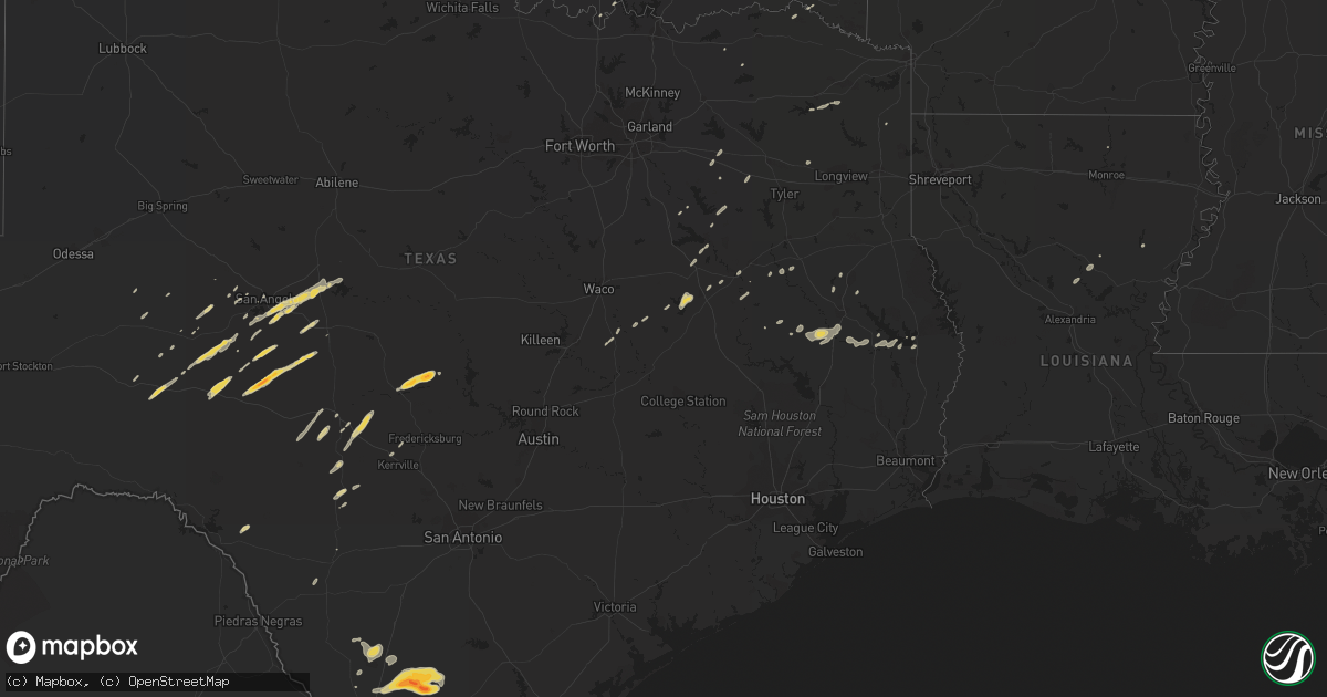
Hail Map on March 8, 2012
Get this storm
March 8 map
$229
one time, instant access
Download today. No call, no setup
Keep the $229
Bought the map and want the full workflow? Apply the entire $229 to a subscription within 7 days. None of it is wasted.
Every map, not just this one
This buys you this map. Subscription and you get every map we run, in the markets you choose from a few cities to whole states to nationwide. Plus real-time alerts the moment a storm fires.
Contact data
Name, contact info, occupancy, even credit band for addresses in the footprint. You go from where it hit to who to call.
Become the source they trust
Unlimited branding weather history reports on demand. You already have the documented answer ready for the property owner, and you are the one who showed up with it.
Property data and RoofTrace estimates
Pull up any address you have got, its value and the exact code rules for that jurisdiction, straight from One Click Code. Then RoofTrace estimates the squares, pitch, and roof value, priced the way you price.
Storm reports
Mississippi
| Date | Description |
|---|---|
| 03/08/20125:44 PM CST | 50-60 mph winds. Structure damage co rd 149 |
| 03/08/20125:33 PM CST | Trees down. |
| 03/08/20125:26 PM CST | 50-60 mph winds. Structure damage co rd 149. |
| 03/08/20125:22 PM CST | Trees down. |
| 03/08/20125:00 PM CST | Trees and power lines down. Roofs off homes. Psbl small tornado |
| 03/08/20124:45 PM CST | Trees and power lines down. Roofs off homes. Psbl small tornado |
| 03/08/20124:45 PM CST | Significant damage was first observed at an automotive repair shop which suffered major metal roof damage and wall failure on the rear of the building. Damage continued |
| 03/08/20124:44 PM CST | A metal garage was extensively damaged at the intersection of tatum pond road and highway 32. A couple of mobile homes experienced roof damage further down tatum pond r |
| 03/08/20124:39 PM CST | *** 2 inj *** the public reported a fallen tree which has damaged a mobile home in charleston. This report was received via local television meteorologist. |
| 03/08/20124:34 PM CST | *** 2 inj *** six mobile homes were shifted off of their foundations with some receiving extensive roof damage. There were a few snapped pine trees as well. Path length |
| 03/07/20126:57 PM CST | Tree down on highway 8. |
| 03/07/20126:40 PM CST | Trees reported down to the north of amory in monroe county as reported by monroe county ema. |
| 03/07/20126:18 PM CST | A tree reported down along new chapel road in the evergreen community of itawamba county as reported by the itawamba county sheriffs office. |
| 03/07/20126:16 PM CST | Widespread tree damage with numerous trees across highway 32 in okolona. Cars struck trees fallen across the highway...but there were no injuries reported at this time. |
| 03/07/20126:02 PM CST | Numerous trees down along highway 32 in van vleet with cars striking fallen trees. No injuries reported at this time. |
Arkansas
| Date | Description |
|---|---|
| 03/08/20124:30 PM CST | Multiple trees and power lines are down in camden and across portions of ouachita county. Time is estimated off of radar. |
Texas
| Date | Description |
|---|---|
| 03/08/20128:50 AM CST | Unspecified structures damaged on fm196 south of blossom. |
| 03/08/20128:05 AM CST | Unspecified structures damaged near the intersection of sh24 and fm198. |
| 03/07/201211:01 PM CST | Near highway 277 and loop 306 intersection |
| 03/07/201210:00 PM CST | Tree blown down in mirando city. |
| 03/07/20129:30 PM CST | Observer reported pea to golf ball sized hail. |
| 03/07/20129:15 PM CST | Observer reported pea to golf ball sized hail. |
| 03/07/20129:10 PM CST | Vehicles with windshields damaged due to hail along highway 59 near the community of ranchitos las lomas. |
| 03/07/20128:01 PM CST | Sheriff deputy reported quarter-sized hail at mile marker 26 on interstate 35. |
Oklahoma
| Date | Description |
|---|---|
| 03/08/20123:45 PM CST | A local report indicates 1.25 inch wind near 4 NE YANUSH |
| 03/08/20123:38 PM CST | A local report indicates 1.00 inch wind near YANUSH |
| 03/08/20122:30 PM CST | A local report indicates 1.00 inch wind near 1 SE CANEY |
| 03/08/20127:39 AM CST | Csm asos |
| 03/08/20127:00 AM CST | A local report indicates 58 MPH wind near 3 W MEDICINE PARK |
Alabama
| Date | Description |
|---|---|
| 03/07/20127:11 PM CST | Trees down on buck jackson road just to the west of the lamar county airport. |
| 03/07/20127:02 PM CST | Trees reported down just east of detroit. |
| 03/07/20127:02 PM CST | Trees reported down in henson springs. |
Cities Impacted by Hail Map on March 8, 2012
- Cotulla, TX
- Tilden, TX
- Encinal, TX
- Mertzon, TX
- Leakey, TX
- Grapeland, TX
- Ozona, TX
- Eldorado, TX
- Junction, TX
- Fort Gibson, OK
- Vanderpool, TX
- Nacogdoches, TX
- Clayton, OK
- La Pryor, TX
- San Angelo, TX
- Sonora, TX
- Rice, TX
- Kerens, TX
- Powell, TX
- Durant, OK
- Mount Pleasant, TX
- Laredo, TX
- Ratcliff, AR
- Ozark, AR
- Paris, AR
- Branch, AR
- Magazine, AR
- Mereta, TX
- Paint Rock, TX
- Big Wells, TX
- Lott, TX
- Rosebud, TX
- Miles, TX
- Sterlington, LA
- Tahlequah, OK
- Hulbert, OK
- Scranton, AR
- Subiaco, AR
- Marlin, TX
- Kosse, TX
- Van, TX
- Ben Wheeler, TX
- Eden, TX
- Caddo, OK
- Oakwood, TX
- Buffalo, TX
- Castell, TX
- Llano, TX
- Valley Spring, TX
- Art, TX
- Mason, TX
- Mirando City, TX
- Oilton, TX
- Antlers, OK
- Pittsburg, TX
- Mena, AR
- Brackettville, TX
- Tuskahoma, OK
- Talihina, OK
- Wisner, LA
- Hebbronville, TX
- Bruni, TX
- Jasper, TX
- Wister, OK
- Foster, OK
- Duncan, OK
- Malakoff, TX
- Donie, TX
- Jewett, TX
- Thornton, TX
- Groesbeck, TX
- Groveton, TX
- Wills Point, TX
- Omaha, TX
- Asherton, TX
- Athens, TX
- Rocksprings, TX
- Zavalla, TX
- Huntington, TX
- Trout, LA
- Crockett, TX
- Christoval, TX
- Lane, OK
- Calumet, OK
- Caney, OK
- Atoka, OK
- Eola, TX
- Lufkin, TX
- Diboll, TX
- Palestine, TX
- Marietta, OK
- Menard, TX
- Brookeland, TX
- Vancourt, TX
- Wall, TX
- Big Sandy, TX
- Fairfield, TX
- Imboden, AR
- Black Rock, AR
- Smithville, AR
- Apple Springs, TX
- Corrigan, TX
- Rusk, TX
- Canton, TX
- Uvalde, TX
- Elkhart, TX
- Kerrville, TX
- Harper, TX
- Kennard, TX
- Bagwell, TX
- Rowena, TX
- Voss, TX
- Ballinger, TX
- Fredericksburg, TX
- Pollock, LA
- Broaddus, TX
- Honey Grove, TX
- Hunt, TX
- Garvin, OK