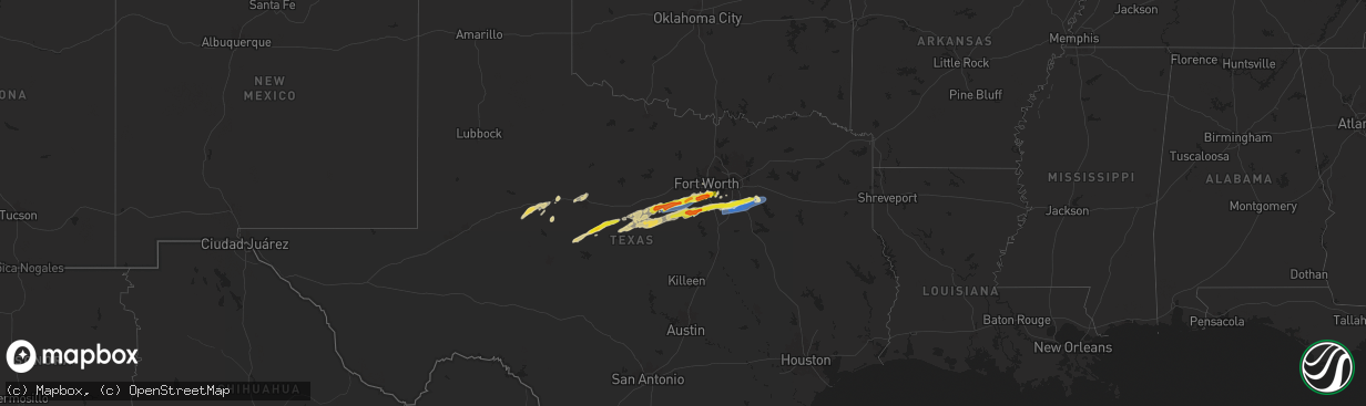
Hail Map on March 7, 2025
The weather event on March 7, 2025 includes Hail and Wind maps. 1 state and 74 cities were impacted and suffered possible damage. The total estimated number of properties impacted is 67,728.
Want more than just the map?
Turn this storm into a full workflow.
- Owner + property data so you know who to knock
- OnDemand branded weather history reports to win the "did we even have hail?" argument
- RoofTrace estimate so reps stop guessing numbers at the door
Bought this map? Upgrade within 7 days and we'll credit the $230. (10-15 min setup call)
Hail
Wind
67,728
Estimated number of impacted properties by a 1.00" hail or larger17,923
Estimated number of impacted properties by a 1.75" hail or larger0
Estimated number of impacted properties by a 2.50" hail or largerStates Impacted by Hail Map on March 7, 2025
Storm reports
Texas
| Date | Description |
|---|---|
| 03/07/20255:55 AM CST | Delayed report. Quarter-sized hail reported in rendon near drury cross rd and gehrig cir. |
| 03/07/20255:54 AM CST | A local report indicates 1.00 inch wind near 2 NNE Burleson |
| 03/07/20255:51 AM CST | Report from mping: half dollar |
| 03/07/20255:50 AM CST | Social media photo. |
| 03/07/20255:49 AM CST | Report from mping: half dollar |
| 03/07/20255:48 AM CST | Report from mping: quarter |
| 03/07/20255:30 AM CST | Overturned 18 wheelers in ennis reported by ennis pd. |
| 03/07/20255:30 AM CST | Delayed report. Quarter-size hail reported 2.6 miles northwest of godley. |
| 03/07/20255:30 AM CST | East facing wall of a grocery store blown off to the east. Metal building. Consistent with wind speeds of 75 to 80 mph. |
| 03/07/20255:20 AM CST | Report from mping: half dollar |
| 03/07/20255:20 AM CST | Damage to a single family one story residence. Partial removal of roof and blown in garage door. Consistent with wind speeds of 80 to 90 mph. |
| 03/07/20255:15 AM CST | Emergency management reports wind damage in granbury near 701 pintail ct. Three bays in the marina were damaged with several sunken boats and jetskis. Widespread uproot |
| 03/07/20255:15 AM CST | Delayed report. Half dollar sized hail reported southwest of waxahachie near the fm 66 and arrowhead rd intersection. |
| 03/07/20255:05 AM CST | About 2 consecutive miles worth of power poles bent or snapped at the base near tolar. Time estimated. |
| 03/07/20254:55 AM CST | Delayed report. Half dollar-sized hail reported 4 miles nw of grandview. |
| 03/07/20254:45 AM CST | Social media picture of quarter sized hail in cleburne. |
| 03/07/20254:45 AM CST | Ham radio operator reports thunderstorm wind damage south of rio vista near 8932 tx 174. Multiple power poles were downed and a carport roof was blow 20-30 yards from i |
| 03/07/20254:42 AM CST | Delayed report. Half dollar sized hail reported in southwest cleburne near gerard elementary school. |
| 03/07/20254:40 AM CST | Delayed report. Wind damage was reported at a residence northeast of stephenville on cr 176. A horse trailer was rolled a couple hundred feet due to the wind and a meta |
| 03/07/20254:30 AM CST | Delayed report. Social media pictures of damage to a home just south of tolar. Metal paneling tossed around... Flag pole bent... Metal structures damaged/destroyed. Nei |
Cities Impacted by Hail Map on March 7, 2025
- Westbrook, TX
- Ballinger, TX
- Blackwell, TX
- Colorado City, TX
- Loraine, TX
- Talpa, TX
- Roscoe, TX
- Brownwood, TX
- May, TX
- Coleman, TX
- Rising Star, TX
- Novice, TX
- Maryneal, TX
- Burkett, TX
- Comanche, TX
- Sweetwater, TX
- Sidney, TX
- Cross Plains, TX
- Cisco, TX
- Trent, TX
- Gorman, TX
- De Leon, TX
- Desdemona, TX
- Merkel, TX
- Dublin, TX
- Stephenville, TX
- Abilene, TX
- Hawley, TX
- Carbon, TX
- Bluff Dale, TX
- Glen Rose, TX
- Walnut Springs, TX
- Hico, TX
- Ranger, TX
- Granbury, TX
- Rainbow, TX
- Cleburne, TX
- Nemo, TX
- Tolar, TX
- Albany, TX
- Godley, TX
- Kopperl, TX
- Rio Vista, TX
- Grandview, TX
- Alvarado, TX
- Keene, TX
- Venus, TX
- Midlothian, TX
- Waxahachie, TX
- Maypearl, TX
- Lipan, TX
- Cresson, TX
- Palmer, TX
- Ennis, TX
- Ferris, TX
- Joshua, TX
- Lueders, TX
- Crowley, TX
- Burleson, TX
- Fort Worth, TX
- Rosser, TX
- Scurry, TX
- Mansfield, TX
- Kaufman, TX
- Kemp, TX
- Arlington, TX
- Italy, TX
- Milford, TX
- Forreston, TX
- Cedar Hill, TX
- Red Oak, TX
- Itasca, TX
- Covington, TX
- Blum, TX