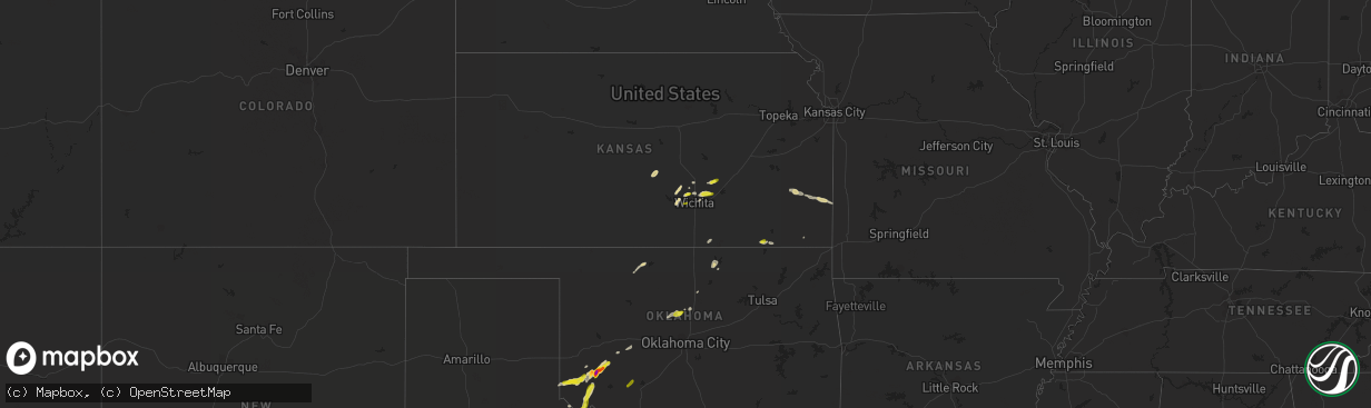
Hail Map on March 7, 2024
The weather event on March 7, 2024 includes Hail map. 5 states and 152 cities were impacted and suffered possible damage. The total estimated number of properties impacted is 14,984.
Want more than just the map?
Turn this storm into a full workflow.
- Owner + property data so you know who to knock
- OnDemand branded weather history reports to win the "did we even have hail?" argument
- RoofTrace estimate so reps stop guessing numbers at the door
Bought this map? Upgrade within 7 days and we'll credit the $230. (10-15 min setup call)
Hail
14,984
Estimated number of impacted properties by a 1.00" hail or larger534
Estimated number of impacted properties by a 1.75" hail or larger347
Estimated number of impacted properties by a 2.50" hail or largerStates Impacted by Hail Map on March 7, 2024
Storm reports
Oklahoma
| Date | Description |
|---|---|
| 03/07/20244:23 PM CST | Report from mping: quarter |
| 03/06/20246:19 PM CST | A local report indicates 2.50 inch wind near Lone Wolf |
Kansas
| Date | Description |
|---|---|
| 03/06/20248:10 PM CST | Delayed report of one in hail in benton. |
California
| Date | Description |
|---|---|
| 03/07/20245:38 PM CST | Quarter size hail. |
Texas
| Date | Description |
|---|---|
| 03/07/20245:06 PM CST | Time estimated by radar. |
| 03/07/20244:55 PM CST | A local report indicates 1.50 inch wind near Crowell |
| 03/07/20244:45 PM CST | Social media photo of golf ball size hail that fell around the possum kingdom area. Time estimated by radar. |
| 03/06/20246:32 PM CST | A facebook post had a picture of quarter size hail at road 618... Which is high road... In coleman... Tx. |
Cities Impacted by Hail Map on March 7, 2024
- Nickerson, KS
- Sterling, KS
- Mount Hope, KS
- Burrton, KS
- Andale, KS
- Garden Plain, KS
- Goddard, KS
- Arkansas City, KS
- Sedgwick, KS
- Garden City, TX
- Sterling City, TX
- Paducah, TX
- Seymour, TX
- Lawton, OK
- Crowell, TX
- Breckenridge, TX
- Robert Lee, TX
- Quanah, TX
- Talpa, TX
- Bronte, TX
- Graford, TX
- Strawn, TX
- Graham, TX
- Valera, TX
- Coleman, TX
- Blackwell, TX
- Chillicothe, TX
- Ballinger, TX
- Norton, TX
- Wingate, TX
- Eldorado, OK
- Olustee, OK
- Altus, OK
- Gould, OK
- Vinson, OK
- Caney, KS
- Niotaze, KS
- Havana, KS
- Blair, OK
- Mangum, OK
- Post, TX
- Lone Wolf, OK
- Hobart, OK
- Rocky, OK
- Granite, OK
- Willow, OK
- Sentinel, OK
- Snyder, TX
- Justiceburg, TX
- Santa Anna, TX
- Brownwood, TX
- Bangs, TX
- Hennessey, OK
- Crescent, OK
- Colwich, KS
- Maize, KS
- Valley Center, KS
- Jayton, TX
- Aspermont, TX
- Potwin, KS
- Burns, KS
- Wichita, KS
- Benton, KS
- Towanda, KS
- Electra, TX
- Cordell, OK
- Independence, KS
- Coffeyville, KS
- Tyro, KS
- Humboldt, KS
- Iola, KS
- La Harpe, KS
- Fort Scott, KS
- Arcadia, KS
- Garland, KS
- Kaw City, OK
- Ponca City, OK
- Burbank, OK
- Moran, KS
- Carmen, OK
- Cherokee, OK
- Comanche, TX
- Blanket, TX
- Early, TX
- May, TX
- Whitewater, KS
- Hollis, OK
- Uniontown, KS
- Elsmore, KS
- Perry, OK
- Kingfisher, OK
- Redfield, KS
- Hepler, KS
- Caddo, TX
- Mulhall, OK
- Newton, KS
- Hydro, OK
- Colony, OK
- Luke Air Force Base, AZ
- Waddell, AZ
- Surprise, AZ
- Porter Ranch, CA
- Granada Hills, CA
- Northridge, CA
- Chatsworth, CA
- Milford, TX
- Italy, TX
- Old Glory, TX
- Comstock, TX
- Itasca, TX
- Sonora, TX
- Dodson, TX
- Junction, TX
- Mountain Home, TX
- Harper, TX
- Stonewall, TX
- Fredericksburg, TX
- Johnson City, TX
- Hye, TX
- Mullin, TX
- Zephyr, TX
- Brookesmith, TX
- Gouldbusk, TX
- Lohn, TX
- Rockwood, TX
- Ozona, TX
- Dryden, TX
- Mason, TX
- Priddy, TX
- Hamilton, TX
- Gustine, TX
- Carlton, TX
- Litchfield Park, AZ
- San Angelo, TX
- Wall, TX
- Eola, TX
- Mereta, TX
- Eldorado, TX
- Glendale, AZ
- Art, TX
- Llano, TX
- Clifton, TX
- Buchanan Dam, TX
- Whitney, TX
- Meridian, TX
- Morgan, TX
- Castell, TX
- Rocksprings, TX
- Blanco, TX
- Palo Pinto, TX
- Bluffton, TX
- Tow, TX