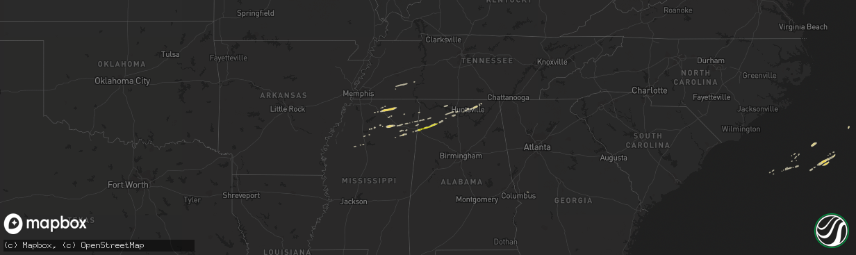
Hail Map on March 5, 2013
The weather event on March 5, 2013 includes Hail map. 4 states and 60 cities were impacted and suffered possible damage. The total estimated number of properties impacted is 935.
Want more than just the map?
Turn this storm into a full workflow.
- Owner + property data so you know who to knock
- OnDemand branded weather history reports to win the "did we even have hail?" argument
- RoofTrace estimate so reps stop guessing numbers at the door
Bought this map? Upgrade within 7 days and we'll credit the $230. (10-15 min setup call)
Hail
935
Estimated number of impacted properties by a 1.00" hail or larger0
Estimated number of impacted properties by a 1.75" hail or larger0
Estimated number of impacted properties by a 2.50" hail or largerStates Impacted by Hail Map on March 5, 2013
Storm reports
Alabama
| Date | Description |
|---|---|
| 03/05/20133:50 PM CST | Several trees down near the intersection of highway 280 and lee rd 379. There was also an automobile accident related to the damage. |
| 03/05/20132:57 PM CST | Several trees snapped along arrowhead rd with at least one lane blocked. One tree down on powerlines. Time estimated from radar. |
| 03/05/20132:52 PM CST | One tree down along wares slough rd. Time estimated from radar. |
| 03/05/20132:43 PM CST | Large tree branch fell onto and damaged a patrol car. Time estimated from radar. |
| 03/05/20132:33 PM CST | One tree down along county road 57 near county road 66. Winds estimated around 40 mph. Time estimated from radar. |
| 03/05/20132:22 PM CST | Tree down on a house near the intersection of 7th street and county rd 24 in verbena. |
| 03/05/20132:19 PM CST | One tree down near the intersection of county roads 24 and 37. Winds estimated around 40 mph. Time estimated from radar. |
| 03/05/20132:14 PM CST | Three large trees down blocking the road near the intersection of county roads 24 and 49. |
| 03/05/20131:51 PM CST | Rainbow/kain ave intersection. Structural damage to storage building behind house. Trees and power lines down. |
| 03/05/20131:48 PM CST | Several sections of roof...approximately 20 ft wide...removed from columbiana middle school. At least two classrooms were damaged. Winds estimated at 70-80 mph. |
| 03/05/20131:30 PM CST | Large tree was blown down on power lines at 40th ave n and 41st n. |
| 03/05/20131:30 PM CST | Wal-mart. Power outage due to lightning striking a telephone pole and also tree limbs falling on power lines. |
| 03/05/20131:25 PM CST | One tree down along hwy 25 near cahawba christian academy. |
| 03/05/20131:22 PM CST | Metal awning/canopy blown off building in downtown. Winds estimated around 40-45 mph. Time estimated from radar. |
| 03/05/20131:13 PM CST | Measured winds 62 mph. Also dime size hail. |
| 03/05/20131:13 PM CST | Measured winds 62 mph. Also dime size hail. |
| 03/05/20131:11 PM CST | At union grove dw2741 cwop station |
| 03/05/201312:18 PM CST | Quarter size hail was reported. |
| 03/05/201312:13 PM CST | Quarter size hail was reported. |
| 03/05/201310:50 AM CST | Reported near the fire department just west of bear creek. |
| 03/05/20139:59 AM CST | Quarter size hail was reported 5 miles west of the highway 31 and 20 intersection. |
South Carolina
| Date | Description |
|---|---|
| 03/05/20135:30 PM CST | Broadcast media relayed reports of trees down and wind damage to outbuildings. |
Mississippi
| Date | Description |
|---|---|
| 03/05/201310:07 AM CST | A local report indicates 1.00 inch wind near 2 SE NETTLETON |
Georgia
| Date | Description |
|---|---|
| 03/05/20135:10 PM CST | Numerous trees reported down just east of danielsville. |
| 03/05/20135:08 PM CST | Reports of significant damage along stanley maxwell road near intersection of rehoboth road. At least 15 trees down and barn demolished. Trees also down on deep creek r |
| 03/05/20134:21 PM CST | Multiple trees reported down in the county as well as moonbridge road east of braselton. Also trees down near nicholson. |
| 03/05/20134:15 PM CST | Marion county 911 relayed a report of a tree down on woody stubbs road. |
| 03/05/20133:55 PM CST | Numerous trees were either blown down or snapped in the north half of the county. Also numerous power outages were reported. |
| 03/05/20133:53 PM CST | A few trees reported down in lumpkin county. |
| 03/05/20133:45 PM CST | Several trees were reported down in lumpkin county. |
| 03/05/20133:45 PM CST | Trees were damaged near moreland. |
| 03/05/20133:45 PM CST | The 911 center reported a tree fell through a house on dr john t pettit street off of cherokee street. |
| 03/05/20133:27 PM CST | Tree down on home south of hiawassee. |
| 03/05/20133:25 PM CST | Powerline down in the vicinity of whitworth church road. |
| 03/05/20133:25 PM CST | A couple of trees are down in canton. One tree across a road and another tree down on powerlines at dr john t petit street in canton. |
| 03/05/20133:11 PM CST | Tree down on a powerline. |
| 03/05/20133:11 PM CST | Trees down east of buchanan. |
| 03/05/20133:10 PM CST | One tree blown down in the cherry log area. |
| 03/05/20133:08 PM CST | One tree was down and the storm was accompanied by nickel sized hail. |
| 03/05/20133:01 PM CST | Trees reported down in the northwest part of the county. |
| 03/05/20133:00 PM CST | Several power outages reported in the buchanan area. |
| 03/05/20133:00 PM CST | One tree was blown down in the mountaintown area. |
| 03/05/20132:50 PM CST | Numerous trees reported down. Ten homes and a daycare were impacted by falling trees. Trees were blown down towards the west. Damage was near the outlet mall on highway |
| 03/05/20132:47 PM CST | Numerous trees down county wide reported by the 911 center. |
| 03/05/20132:40 PM CST | Numerous trees reported down across the county. |
| 03/05/20132:36 PM CST | A home on mitchell bridge road received damage from falling trees. |
| 03/05/20132:35 PM CST | A home on concord drive received damage from a tree falling on it. |
| 03/05/20132:33 PM CST | Multiple trees reported down and pea sized hail also occurred. |
| 03/05/20132:00 PM CST | 911 center reported one tree down at beaver avenue and lafayette road. |
| 03/05/20131:55 PM CST | 911 center reported a few trees down in the north end of the county. |
| 03/05/20136:30 AM CST | Utility company reports trees and powerlines down across sotuhern sections of washington county. |
| 03/04/20136:50 PM CST | Trees down at hwy 56 and dilane plantation rd. |
| 03/04/20136:43 PM CST | Georgia electric coop emc reported several power outages across southern burke county due to trees on powerlines. |
| 03/04/20136:43 PM CST | Georgia electric coop emc reported several power outages across portions of southern burke county due to trees on powerlines. |
| 03/04/20136:30 PM CST | Utility company reports trees and powerlines down across sotuhern sections of washington county. |
| 03/04/20136:04 PM CST | Windows on the west side of the house was blown out. A camper was also blown 50 yards into the woods. |
| 03/04/20136:04 PM CST | Roof blown off of magnolia baptist church. The back wall was also blown out. |
| 03/04/20136:03 PM CST | Mobile home blown off its foundation. This is a duplicate report of the tornado that occurred in glascock county. |
| 03/04/20136:03 PM CST | Windows on the west side of the house was blown out. A camper was also blown 50 yards into the woods. This is a duplicate report of the ef1 tornado in glascock county. |
| 03/04/20136:02 PM CST | A national weather service storm survey determined that an ef1 tornado touched down northwest of gibson. Numerous trees were snapped and uprooted along the 1.5 mile pat |
Cities Impacted by Hail Map on March 5, 2013
- Ripley, MS
- Blue Mountain, MS
- Hickory Flat, MS
- Water Valley, MS
- Oxford, MS
- Moulton, AL
- Potts Camp, MS
- Holly Springs, MS
- Ashland, MS
- Hamilton, AL
- Plantersville, MS
- Huntsville, AL
- Haleyville, AL
- Phil Campbell, AL
- Nettleton, MS
- Tremont, MS
- Trinity, AL
- Ecru, MS
- Belden, MS
- Pontotoc, MS
- Gurley, AL
- Hackleburg, AL
- Athens, AL
- Rogersville, AL
- Finger, TN
- Henderson, TN
- Russellville, AL
- Decatur, AL
- Trenton, AL
- Hollytree, AL
- Brownsboro, AL
- Princeton, AL
- Tillatoba, MS
- Oakland, MS
- Tupelo, MS
- Shannon, MS
- Fulton, MS
- Waterford, MS
- Cherokee, AL
- Red Bay, AL
- Golden, MS
- Mantachie, MS
- Saltillo, MS
- Myrtle, MS
- New Albany, MS
- Coffeeville, MS
- Scottsboro, AL
- Bear Creek, AL
- Tanner, AL
- Courtland, AL
- Hillsboro, AL
- Box Springs, GA
- Vina, AL
- Philipp, MS
- Thaxton, MS
- Booneville, MS
- Sardis, TN
- Saltillo, TN
- Amory, MS
- Okolona, MS