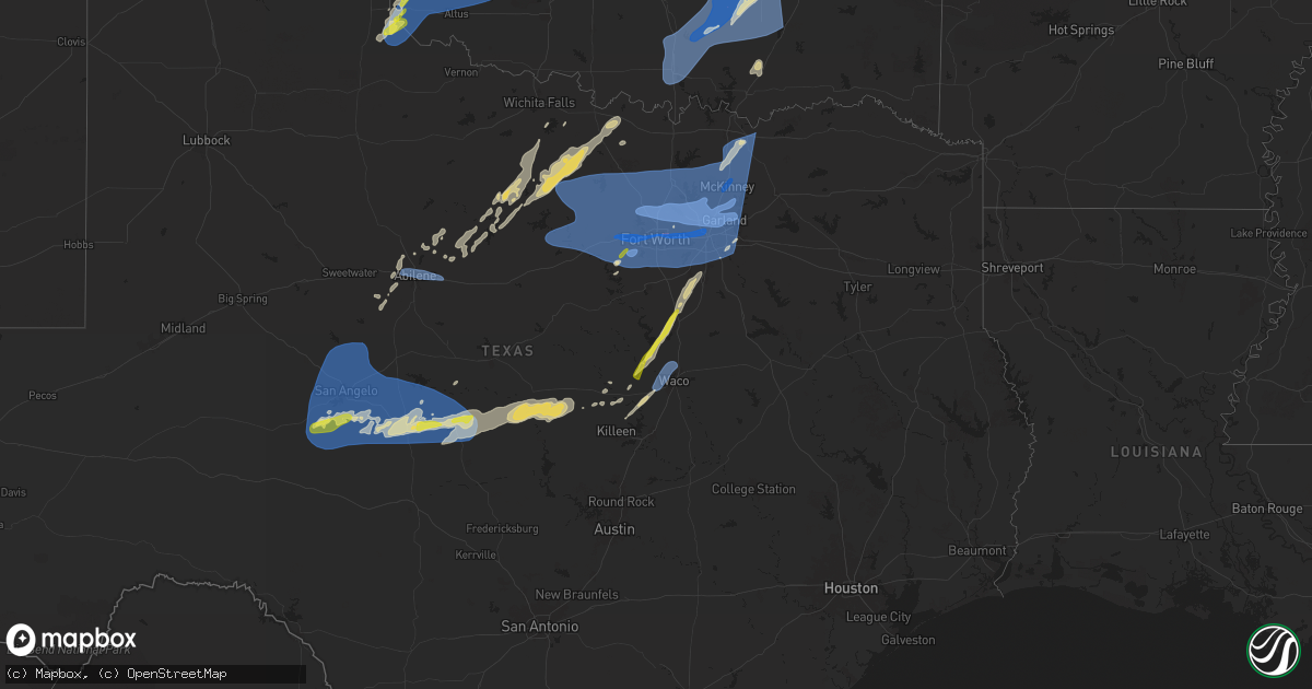
Hail Map on March 3, 2025
Get this storm
March 3 map
$229
one time, instant access
Download today. No call, no setup
Keep the $229
Bought the map and want the full workflow? Apply the entire $229 to a subscription within 7 days. None of it is wasted.
Every map, not just this one
This buys you this map. Subscription and you get every map we run, in the markets you choose from a few cities to whole states to nationwide. Plus real-time alerts the moment a storm fires.
Contact data
Name, contact info, occupancy, even credit band for addresses in the footprint. You go from where it hit to who to call.
Become the source they trust
Unlimited branding weather history reports on demand. You already have the documented answer ready for the property owner, and you are the one who showed up with it.
Property data and RoofTrace estimates
Pull up any address you have got, its value and the exact code rules for that jurisdiction, straight from One Click Code. Then RoofTrace estimates the squares, pitch, and roof value, priced the way you price.
Storm reports
Texas
| Date | Description |
|---|---|
| 03/03/20255:55 AM CST | Pole barn heavily damaged on cr 697 southeast of farmersville. Time estimated via radar. |
| 03/03/20255:53 AM CST | Overturned 18 wheeler reported on southbound i-35e at bear creek rd in glenn heights. |
| 03/03/20255:52 AM CST | Power pole snapped at parker and alma in plano. |
| 03/03/20255:51 AM CST | Power lines down in grapevine. |
| 03/03/20255:50 AM CST | Rvs overturned from high winds near the 14500 block of white settlement rd in parker county. |
| 03/03/20255:50 AM CST | 18 wheeler rolled over on sb i-35w at cross timbers rd. Road was shut down. |
| 03/03/20255:47 AM CST | 60 mph wind gust measured at fire station 4 in richardson. |
| 03/03/20255:42 AM CST | Social media report of commercial building damage near kentucky st and mccauley st in mckinney. |
| 03/03/20255:41 AM CST | 63 mph wind gust measured at the ktki asos. |
| 03/03/20255:40 AM CST | 78 mph wind gust measured at the kdal asos. |
| 03/03/20255:38 AM CST | Report of considerable damage to a residence. Portions of the roof were destroyed. Another residence lost the portions of the chimney. Large tree limbs were down in the |
| 03/03/20255:38 AM CST | 69 mph wind gust reported in prosper. |
| 03/03/20255:37 AM CST | Multiple homes in the stone hill neighborhood in cedar hill sustained damage in roofs... Fences... And street signs. |
| 03/03/20255:37 AM CST | Report from mping. Quarter size hail. |
| 03/03/20255:36 AM CST | 58 mph wind gust measured by the krbd asos. |
| 03/03/20255:31 AM CST | 82 mph wind gust measured 1 mile southeast of hebron pkwy and josey ln in carrollton. |
| 03/03/20255:30 AM CST | Large trees damaged or uprooted along clements road. Report also included damage to multiple metal roofs in the same area. |
| 03/03/20255:30 AM CST | Roof damage at plano west senior high. Time estimated via radar. |
| 03/03/20255:29 AM CST | Structural collapse of large warehouse on eb highway 121 near leora ln. |
| 03/03/20255:29 AM CST | 60 mph wind gust measured by the kgky asos. |
| 03/03/20255:29 AM CST | 74 mph wind gust measured by the kdfw asos. |
| 03/03/20255:26 AM CST | Damage reported in irving between macarthur blvd... N britain rd... Rock island rd... And union bower. Damage to two apartment complexes... Government buildings... And |
| 03/03/20255:25 AM CST | 62 mph wind gust measured at north east mall in hurst. |
| 03/03/20255:20 AM CST | Corrects previous tstm wnd dmg report from 1 sw grapevine. Power lines down in grapevine. |
| 03/03/20255:20 AM CST | Multiple 6-12 branches/split trees down near intersection of perkins rd and pleasant wood trl. |
| 03/03/20255:16 AM CST | 72 mph wind gust reported by kact asos. |
| 03/03/20255:15 AM CST | Social media report of tree damage at green oaks blvd and fielder rd in north arlington. |
| 03/03/20255:15 AM CST | Report from mping: trees uprooted or snapped or roof blown off. |
| 03/03/20255:13 AM CST | 60 mph wind gust measured by the kdto asos. |
| 03/03/20255:11 AM CST | 80 mph winds estimated in decatur. A 2 ft tree was uprooted. |
| 03/03/20255:07 AM CST | 76 mph wind gust measured by the kafw asos. |
| 03/03/20255:05 AM CST | Multiple trees in road on cannon pkwy in roanoke. Road barriers were moved into roadway on eb and wb 114 from al slaughter to i-35w. |
| 03/03/20255:05 AM CST | 62 mph wind gust measured by awos at nas jrb. |
| 03/03/20255:03 AM CST | Report from mping. Quarter size hail. |
| 03/03/20255:03 AM CST | Corrects previous tstm wnd dmg report from 1 se northlake. 18 wheeler rolled over on sb i-35w at cross timbers rd. Road was shut down. |
| 03/03/20255:03 AM CST | Report from mping. Quarter size hail. |
| 03/03/20254:59 AM CST | 74 mph wind gust measured at a cwop site in western fort worth. |
| 03/03/20254:55 AM CST | Report from mping: trees uprooted or snapped or roof blown off. |
| 03/03/20254:46 AM CST | Report from mping. Quarter size hail. |
| 03/03/20254:40 AM CST | Corrects previous tstm wnd dmg report from 5 ene willow park. Rvs overturned from high winds near the 14500 block of white settlement rd in parker county. |
| 03/03/20254:38 AM CST | 70 mph wind gust measured on the west side of decatur. |
| 03/03/20254:32 AM CST | Measured 66 mph wind gust near fm 920 - 1.7 miles south of poolville. |
| 03/03/20254:32 AM CST | 66 mph wind gust measured in poolville. |
| 03/03/20254:30 AM CST | The roof was ripped off the second story of a home on cr 1742. Power line damage was also reported on cr 1742. |
| 03/03/20254:28 AM CST | 59 mph wind gust measured by the mineral wells asos. |
| 03/03/20254:11 AM CST | Report from mping: quarter |
| 03/03/20253:27 AM CST | A local report indicates 59 MPH wind near 3 WNW Doole |
| 03/03/20253:05 AM CST | Report from mping: 1-inch tree limbs broken; shingles blown off. |
| 03/03/20252:46 AM CST | The tom green county sherriff reported that power lines were down along wood road... Between susan peak road and us highway 87. |
| 03/03/20252:42 AM CST | A local report indicates 62 MPH wind near 4 SE Abilene |
| 03/03/20252:41 AM CST | The public reported up to quarter size hail. |
| 03/03/20252:27 AM CST | A local report indicates 60 MPH wind near 3 SE Grape Creek |
Kansas
| Date | Description |
|---|---|
| 03/02/202510:00 PM CST | Public report on social media mentioning nickel to quarter sized hail 1 1/2 miles northeast of cairo. |
Oklahoma
| Date | Description |
|---|---|
| 03/03/20255:54 AM CST | 65-70 mph winds. |
| 03/03/20255:40 AM CST | Multiple reports of trees in roadways in durant. Time estimated by radar. |
| 03/03/20255:36 AM CST | Hwy 22&78 at nida debris in roadway and power poles broken 5:38. |
| 03/03/20255:25 AM CST | Allen is reporting multiple buildings with roof damage. Tornado possible. |
| 03/03/20255:19 AM CST | Power poles down highway 7&1 intersect south near mill creek. |
| 03/03/20255:16 AM CST | The union valley tornado developed just east of state highway 3 along county road e1600. The tornado moved east-northeast. One home received roof damage... The union va |
| 03/03/20255:15 AM CST | Multiple reports of significant damage around ada... Especially across the southern part of town. Time is estimated at this time. |
| 03/03/20255:15 AM CST | Funnel cloud also observed. |
| 03/03/20255:15 AM CST | 40-50 powerlines down across southern part of county. Time estimated by radar 5:15 to 5:25 am. |
| 03/03/20255:10 AM CST | A local report indicates 79 MPH wind near 6 SW Fittstown |
| 03/03/20255:07 AM CST | Barn and outbuildings damaged east of scullin y hwy 7 & 1. |
| 03/03/20255:05 AM CST | A local report indicates 87 MPH wind near 6 SW Fittstown |
| 03/03/20254:55 AM CST | A local report indicates 60 MPH wind near 1 NNE Gene Autry |
| 03/03/20254:40 AM CST | Barn damage. Hwy 53 about .5 miles east of gene autry debris was scattered about 1/4 mile or more down highway. Time estimated by radar. |
| 03/03/20252:05 AM CST | A local report indicates 1.00 inch wind near Jones |
| 03/02/202510:20 PM CST | A local report indicates 59 MPH wind near 6 SSE Eagle City |
| 03/02/202510:20 PM CST | A local report indicates 59 MPH wind near 4 WNW Bessie |
| 03/02/20259:48 PM CST | Damage to an unoccupied recreational vehicle and barn. |
| 03/02/20259:48 PM CST | A local report indicates 1.00 inch wind near 6 S Hammon |
| 03/02/20259:44 PM CST | A local report indicates 1.00 inch wind near 2 N Moorewood |
Cities Impacted by Hail Map on March 3, 2025
- Vici, OK
- Leedey, OK
- Hammon, OK
- Cheyenne, OK
- Camargo, OK
- Erick, OK
- Sayre, OK
- Willow, OK
- Butler, OK
- Elk City, OK
- Mooreland, OK
- Taloga, OK
- Childress, TX
- Carter, OK
- Hollis, OK
- Gould, OK
- Mangum, OK
- Vinson, OK
- Quanah, TX
- Seiling, OK
- Mutual, OK
- Sharon, OK
- Canute, OK
- Custer City, OK
- Blair, OK
- Clinton, OK
- Arapaho, OK
- Putnam, OK
- Foss, OK
- Cordell, OK
- Lone Wolf, OK
- Dill City, OK
- Sentinel, OK
- Hobart, OK
- Granite, OK
- Olustee, OK
- Duke, OK
- Altus, OK
- Chester, OK
- Thomas, OK
- Corn, OK
- Bessie, OK
- Watonga, OK
- Geary, OK
- Oakwood, OK
- Weatherford, OK
- Fay, OK
- Canton, OK
- Longdale, OK
- Hitchcock, OK
- Fairview, OK
- Southard, OK
- Okeene, OK
- Eldorado, OK
- Rocky, OK
- Colony, OK
- Hydro, OK
- Hastings, NE
- Greenfield, OK
- Gotebo, OK
- Hinton, OK
- Trumbull, NE
- Okarche, OK
- Kingfisher, OK
- Loyal, OK
- Omega, OK
- Calumet, OK
- Bradshaw, NE
- Drummond, OK
- Ames, OK
- Hennessey, OK
- Carnegie, OK
- Waukomis, OK
- Roosevelt, OK
- Bison, OK
- Dover, OK
- Lookeba, OK
- Mountain Park, OK
- Headrick, OK
- Mountain View, OK
- Binger, OK
- Fort Cobb, OK
- El Reno, OK
- Lawton, OK
- Gracemont, OK
- Anadarko, OK
- Minco, OK
- Murray, NE
- Plattsmouth, NE
- Nehawka, NE
- Glenwood, IA
- Pacific Junction, IA
- Emerson, IA
- Big Lake, TX
- Red Oak, IA
- Ozona, TX
- Villisca, IA
- Cumberland, IA
- Grant, IA
- Elliott, IA
- Corning, IA
- Massena, IA
- Carthage, IL
- Albany, TX
- Blackwell, TX
- Graham, TX
- Newcastle, TX
- Moran, TX
- Breckenridge, TX
- Woodson, TX
- Merkel, TX
- Tuscola, TX
- Mertzon, TX
- Wingate, TX
- Hawley, TX
- Macomb, IL
- Bushnell, IL
- Nolan, TX
- Olney, TX
- Abilene, TX
- Winterset, IA
- Christoval, TX
- Van Meter, IA
- San Angelo, TX
- Windthorst, TX
- Loving, TX
- Holliday, TX
- Lueders, TX
- South Bend, TX
- West Des Moines, IA
- Cumming, IA
- Des Moines, IA
- Vancourt, TX
- Wichita Falls, TX
- Eden, TX
- Bryson, TX
- Jacksboro, TX
- Jermyn, TX
- Menard, TX
- Bronte, TX
- Robert Lee, TX
- Carlsbad, TX
- Eldorado, TX
- Goodfellow Afb, TX
- Miles, TX
- Wall, TX
- Eola, TX
- Mereta, TX
- Paint Rock, TX
- Millersview, TX
- Melvin, TX
- Rowena, TX
- Lohn, TX
- Bowie, TX
- Bellevue, TX
- Henrietta, TX
- Rockwood, TX
- Brady, TX
- Doole, TX
- Rochelle, TX
- Richland Springs, TX
- Nocona, TX
- Montague, TX
- San Saba, TX
- Overbrook, OK
- Lone Grove, OK
- Marietta, OK
- Davis, OK
- Ardmore, OK
- Springer, OK
- Sulphur, OK
- Mannsville, OK
- Mill Creek, OK
- Dougherty, OK
- Roff, OK
- Crawford, TX
- Valley Mills, TX
- Granbury, TX
- Weatherford, TX
- Goldthwaite, TX
- Moody, TX
- Oglesby, TX
- McGregor, TX
- Gatesville, TX
- Forestburg, TX
- Clifton, TX
- Whitney, TX
- Aquilla, TX
- Hillsboro, TX
- Tishomingo, OK
- Stonewall, OK
- Tupelo, OK
- Milburn, OK
- Wapanucka, OK
- Fitzhugh, OK
- Ada, OK
- Fittstown, OK
- Itasca, TX
- Lometa, TX
- Cresson, TX
- Allen, OK
- Sasakwa, OK
- Konawa, OK
- Holdenville, OK
- Dallas, TX
- Lampasas, TX
- Maypearl, TX
- Waxahachie, TX
- Venus, TX
- Grandview, TX
- Milford, TX
- Evant, TX
- Atwood, OK
- Calvin, OK
- Stuart, OK
- Centrahoma, OK
- Coalgate, OK
- Midlothian, TX
- Celina, TX
- Anna, TX
- Van Alstyne, TX
- Wetumka, OK
- Lamar, OK
- Mcalester, OK
- Dustin, OK
- Weleetka, OK
- Paradise, TX
- Bridgeport, TX
- Boyd, TX
- Azle, TX
- Fort Worth, TX
- Newark, TX
- North Richland Hills, TX
- Bedford, TX
- Haslet, TX
- Keller, TX
- Rhome, TX
- Hurst, TX
- Decatur, TX
- Lewisville, TX
- Denton, TX
- Southlake, TX
- Justin, TX
- Krum, TX
- Ponder, TX
- Colleyville, TX
- Argyle, TX
- Flower Mound, TX
- Roanoke, TX
- Carrollton, TX
- Little Elm, TX
- Arlington, TX
- Irving, TX
- Addison, TX
- Euless, TX
- Lake Dallas, TX
- Aubrey, TX
- Grapevine, TX
- The Colony, TX
- Balch Springs, TX
- Frisco, TX
- Mesquite, TX
- Grand Prairie, TX
- Coppell, TX
- Seagoville, TX
- Melissa, TX
- Sachse, TX
- Richardson, TX
- Sunnyvale, TX
- Blue Ridge, TX
- Farmersville, TX
- Garland, TX
- Rowlett, TX
- Prosper, TX
- Wylie, TX
- Allen, TX
- Plano, TX
- Nevada, TX
- Mckinney, TX
- Rockwall, TX
- Forney, TX
- Princeton, TX
- Lavon, TX
- Haltom City, TX
- Bells, TX
- Whitewright, TX
- Caddo, OK
- Caney, OK
- Clearwater, NE
- Versailles, MO
- Columbia, MO
- Ashland, MO
- Sherman, TX
- Howe, TX
- Tom Bean, TX
- Kenefic, OK
- Palo Pinto, TX
- Graford, TX
- Chico, TX
- Springtown, TX
- Poolville, TX
- Perrin, TX
- Mineral Wells, TX
- Whitt, TX
- Strawn, TX
- Gordon, TX
- Millsap, TX
- Aledo, TX
- Santo, TX
- Burleson, TX
- Naval Air Station Jrb, TX
- Crowley, TX
- Kennedale, TX
- Mansfield, TX
- Duncanville, TX
- Desoto, TX
- Cedar Hill, TX
- Lancaster, TX
- Hutchins, TX
- Leonard, TX
- Bonham, TX
- Trenton, TX
- Savoy, TX
- Ector, TX
- Ravenna, TX
- Gunter, TX
- Tye, TX
- Dyess Afb, TX
- Clyde, TX
- Baird, TX
- Voss, TX
- Gouldbusk, TX
- Joshua, TX
- Godley, TX
- Lipan, TX
- Santa Anna, TX
- Wilmer, TX
- Alvord, TX
- Sanger, TX
- Pilot Point, TX
- Red Oak, TX
- Alvarado, TX
- Woodway, TX
- Ferris, TX
- Waco, TX
- China Spring, TX
- Elm Mott, TX
- Atoka, OK
- Wardville, OK