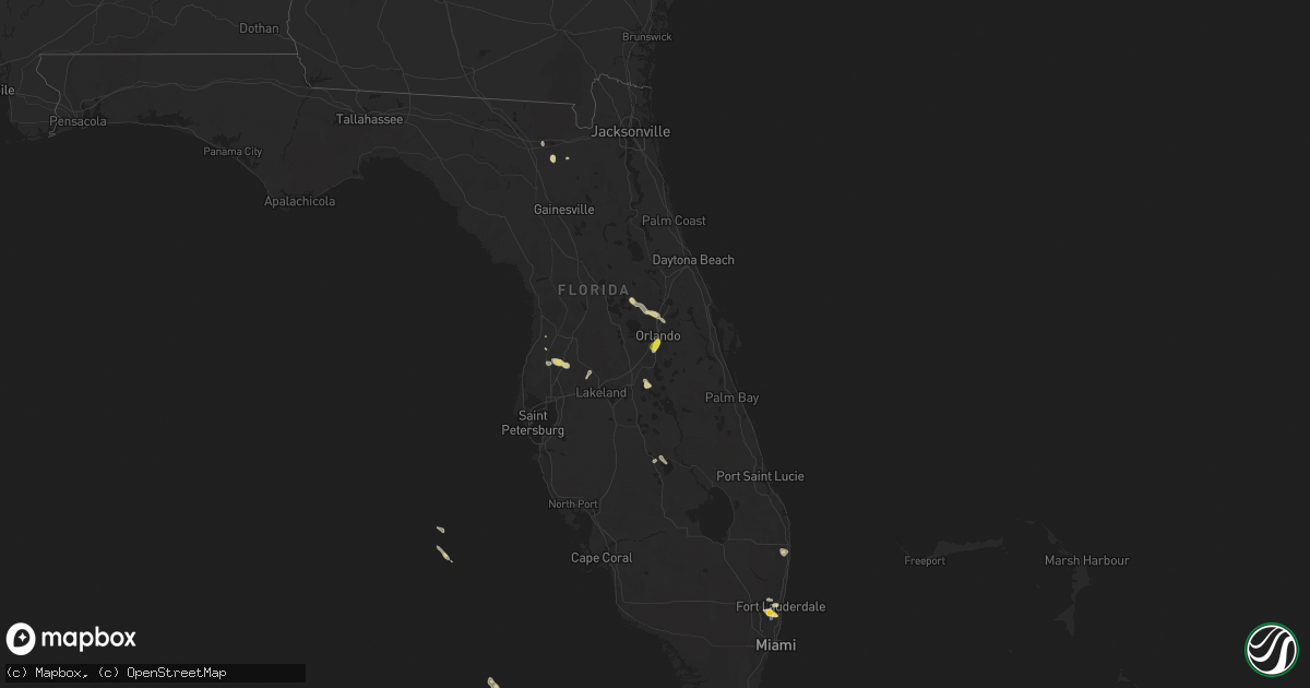
Hail Map on March 3, 2024
Get this storm
March 3 map
$229
one time, instant access
Download today. No call, no setup
Keep the $229
Bought the map and want the full workflow? Apply the entire $229 to a subscription within 7 days. None of it is wasted.
Every map, not just this one
This buys you this map. Subscription and you get every map we run, in the markets you choose from a few cities to whole states to nationwide. Plus real-time alerts the moment a storm fires.
Contact data
Name, contact info, occupancy, even credit band for addresses in the footprint. You go from where it hit to who to call.
Become the source they trust
Unlimited branding weather history reports on demand. You already have the documented answer ready for the property owner, and you are the one who showed up with it.
Property data and RoofTrace estimates
Pull up any address you have got, its value and the exact code rules for that jurisdiction, straight from One Click Code. Then RoofTrace estimates the squares, pitch, and roof value, priced the way you price.
States Impacted by Hail Map on March 3, 2024
Storm reports
Wisconsin
| Date | Description |
|---|---|
| 03/02/20246:39 PM CST | Photo of a quarter sized hailstone next to a ruler sent in via social media. |
Florida
| Date | Description |
|---|---|
| 03/03/20243:48 PM CST | Member of the public shared two videos of nickel-to-quarter sized hail falling as a strong thunderstorm moved through the area. |
| 03/03/20243:46 PM CST | Asos station khwo pembroke pines reported wind gust of 50 kts |
| 03/03/20243:45 PM CST | Member of the public reports quarter sized hail in east davie. |
| 03/03/20243:42 PM CST | City of hollywood reports numerous trees down in the vicinity of sheridan st and the florida turnpike. Time estimated from radar. |
| 03/03/20243:39 PM CST | Earth networks mesonet clwch seminole tribe headquarters recorded a gust of 64 mph at 4:39 pm as a severe thunderstorm moved through the area. Site elevation is listed |
| 03/03/20243:34 PM CST | Fpl power crews reported several large tree branches and trees down on power lines resulted in power outages in the vicinity of griffin rd & davie rd extension. Fpl met |
| 03/03/20243:30 PM CST | Video and photos showing hail between 1 and 1.5 inches in diameter. |
Cities Impacted by Hail Map on March 3, 2024
- Orlando, FL
- Fort Lauderdale, FL
- Hollywood, FL
- Lake Butler, FL
- Kissimmee, FL
- Wesley Chapel, FL
- Land O'Lakes, FL
- San Antonio, FL
- Lake Worth, FL
- Lake Worth Beach, FL
- Boynton Beach, FL
- Kathleen, FL
- Spring Hill, FL
- Warrior, AL
- Hamlin, IA
- Lexington, TN
- Moulton, AL
- Patton, MO
- Adair, IA
- Purdin, MO
- Inverness, FL
- Williamsburg, MO
- Georgetown, GA
- Alcester, SD
- Wessington, SD
- Milan, TN
- Dade City, FL
- Correctionville, IA
- Madison, MO
- Brookfield, MO
- Mayo, FL
- Seneca, SD
- Hickman, KY
- Bridgewater, SD
- Park Hills, MO
- Town Creek, AL
- Cullman, AL
- New Madrid, MO
- Jackson, TN
- Remlap, AL
- Glenallen, MO
- New Haven, MO
- Centralia, MO
- Goodwater, AL
- Dunnellon, FL
- Thayer, IA
- Letcher, SD
- Trussville, AL
- Milan, MO
- Oran, MO
- Gerald, MO
- Shannon City, IA
- Sturgeon, MO
- Tolstoy, SD
- Hoven, SD
- Clark, MO
- Rhineland, MO
- Essex, MO
- Danville, AL
- Bridgewater, IA
- Java, SD
- Ute, IA
- Killdeer, ND
- Parker, SD
- Cairo, MO
- Ironton, MO
- Galt, MO
- Highmore, SD
- Hernando, FL
- Hurley, SD
- Cuthbert, GA
- Hayden, AL
- Princeton, MO
- Trafford, AL
- Denison, IA
- Raleigh, ND
- Defiance, IA
- Manilla, IA
- Selfridge, ND
- Brayton, IA
- Spickard, MO
- Hawarden, IA
- Eufaula, AL
- Addison, AL
- Vinemont, AL
- Schleswig, IA
- Grand River, IA
- Fedora, SD
- Rutherford, TN
- Marble Hill, MO
- Lineville, IA
- Dickinson, ND
- Hermann, MO
- Orient, IA
- Dow City, IA
- Zalma, MO
- Eagle Lake, FL
- Matthews, MO
- New Cambria, MO
- Beaufort, MO
- Davis, SD
- Carson, ND
- Bucklin, MO
- Kenton, TN
- Irwin, IA
- Childersburg, AL
- McLaughlin, SD
- Hanceville, AL
- Troy, TN
- Talladega, AL
- Bradford, TN
- Wakpala, SD
- Alpine, AL
- Coleman, GA
- Lamont, FL
- Leon, IA
- Ricketts, IA
- Beresford, SD
- Lake Wales, FL
- Mineral Point, MO
- Canistota, SD
- Potosi, MO
- Alpena, SD
- Reagan, TN
- Centerville, SD
- Gladstone, ND
- Fredericktown, MO
- Moberly, MO
- Alexander City, AL
- Bartow, FL
- Harris, MO
- Cairo, GA
- Inglis, FL
- Spencer, SD
- Canova, SD
- Leighton, AL
- Anita, IA
- Chatsworth, IA
- Merrill, IA
- Kingsley, IA
- Jacksons Gap, AL
- Huron, TN
- Moody, AL
- Humphreys, MO
- Tingley, IA
- Wiota, IA
- Artesian, SD
- Mexico, MO
- Harlan, IA
- Crystal River, FL
- Onaka, SD
- Okeechobee, FL
- Farmington, MO
- Saltillo, TN
- Viborg, SD
- Battle Creek, IA
- Avon Park, FL
- Glen Ullin, ND
- Gettysburg, SD
- Arlington, GA
- Winigan, MO
- Oto, IA
- Dadeville, AL
- Florence, AL
- Hallsville, MO
- New Boston, MO
- Richwoods, MO
- Sylacauga, AL
- Winter Haven, FL
- Smithland, IA
- Virgil, SD
- Lorida, FL
- Mapleton, IA
- Thompson, MO
- Doe Run, MO
- Lutts, TN
- Clifton Hill, MO
- Greenfield, IA
- Kellyton, AL
- Cross City, FL
- Marquand, MO
- Sikeston, MO
- Elk Point, SD
- Bevier, MO
- Advance, MO
- Sterrett, AL
- Atwood, TN
- Westfield, IA
- South Bay, FL
- Morris, GA
- Marion, SD
- Pinson, AL
- Greenville, FL
- Morrison, MO
- Manning, ND
- Cypress Inn, TN
- Lakeland, FL
- Edison, GA
- Blythedale, MO
- Nobleton, FL
- Emery, SD
- Logan, AL
- Miller, SD
- Jacksonville, MO
- Opelika, AL
- Fairfield, ND
- Owensville, MO
- Richardton, ND
- Selby, SD
- Mound City, SD
- Faulkton, SD
- Savannah, TN
- Portland, MO
- Beverly Hills, FL
- Lawton, IA
- Olivehill, TN
- Woonsocket, SD
- Manning, IA
- Salisbury, MO
- Hinton, IA
- Mitchell, SD
- Irondale, MO
- Saint Lawrence, SD
- Floral City, FL
- Bismarck, MO
- Crane Hill, AL
- Cedar Grove, TN
- Fort Yates, ND
- Auburn, AL
- Kimballton, IA
- Ochlocknee, GA
- Creston, IA
- Alexandria, SD
- New Leipzig, ND
- Vincent, AL
- Webster, FL
- Kingdom City, MO
- Taylor, ND
- Montgomery City, MO
- Atlantic, IA
- Notasulga, AL
- Charter Oak, IA
- Fontanelle, IA
- Union Springs, AL
- Cainsville, MO
- Lecanto, FL
- Thomasville, GA
- Hebron, ND
- Vandiver, AL
- Hatchechubbee, AL
- Lavinia, TN
- Afton, IA
- Camp Hill, AL
- Lamoni, IA
- Exira, IA
- Arion, IA
- Brooksville, FL
- Excello, MO
- Lebanon, SD
- Le Mars, IA
- Steedman, MO
- Wolsey, SD
- Audubon, IA
- Callao, MO
- Davis City, IA
- Rosebud, MO
- Collinwood, TN
- Linneus, MO
- Sullivan, MO
- Leary, GA
- Pell City, AL
- Mercer, MO
- Camilla, GA
- Perry, FL
- Fulton, MO
- Polk City, FL
- Newton, GA
- Shields, ND
- Chiefland, FL
- Pelham, GA
- Union City, TN
- Elk Horn, IA
- Moville, IA
- Kirkman, IA
- Sardis, TN
- Elgin, ND
- Orient, SD
- Leeds, AL
- Huron, SD
- Whigham, GA
- Hurtsboro, AL
- Fulton, SD
- Leslie, MO
- Morris Chapel, TN
- Auburndale, FL
- Glenham, SD
- Kellerton, IA
- Anthon, IA
- Akron, IA
- Mobridge, SD
- Ellston, IA
- Danbury, IA
- Huntsville, MO
- Browning, MO
- Waterloo, AL
- Decatur, IA
- Monticello, FL
- Scotts Hill, TN
- Old Town, FL
- Frostproof, FL
- Rives, TN
- Morgan, GA
- Sioux City, IA
- Bath Springs, TN
- Muscle Shoals, AL
- Clifton, TN
- Flasher, ND
- Auxvasse, MO
- Tuscumbia, AL
- Trenton, TN
- Bushnell, FL
- Pierson, IA
- Sebring, FL
- Pittsview, AL
- Cadet, MO
- Bourbon, MO
- Sturdivant, MO
- Bell City, MO
- Winfield, IA
- Kingston Springs, TN
- Beardstown, IL
- Virginia, IL
- Pegram, TN
- Donnelly, MN
- Ashland City, TN
- Herman, MN
- Huntland, TN
- Shiloh, GA
- Prinsburg, MN
- Andersonville, GA
- Bisbee, ND
- Tintah, MN
- Delavan, MN
- Clarksville, TN
- Dysart, IA
- Ty Ty, GA
- Sylvester, GA
- Raritan, IL
- Dix, IL
- Homestead, IA
- Greenville, GA
- Mcville, ND
- Frederick, IL
- Morning Sun, IA
- Fort White, FL
- Macedonia, IL
- Clermont, FL
- Morris, MN
- Scottsboro, AL
- Carlyle, IL
- Dumont, IA
- Roopville, GA
- Junction, IL
- Jasper, FL
- Flintville, TN
- Sumner, GA
- South Amana, IA
- Nilwood, IL
- Virden, IL
- Wildwood, FL
- Clear Lake, IA
- Girard, IL
- Broughton, IL
- Alexander, IL
- Hogansville, GA
- Carman, IL
- Lewisburg, TN
- Oxford, IA
- Collinsville, AL
- Elizabethtown, IL
- Petersburg, TN
- The Villages, FL
- College Grove, TN
- Waco, GA
- Ainsworth, IA
- Fredonia, KY
- Micanopy, FL
- Hillsboro, IL
- Devils Lake, ND
- Marion, KY
- Columbus Junction, IA
- Fayetteville, TN
- Dunseith, ND
- Litchfield, IL
- Thompsons Station, TN
- Wellborn, FL
- Jacksonville, IL
- Bristow, IA
- Lake Park, GA
- Wheatland, ND
- Easton, MN
- Cedar Bluff, AL
- Tallapoosa, GA
- Carrollton, GA
- Blomkest, MN
- Alachua, FL
- Kerkhoven, MN
- Section, AL
- Colchester, IL
- Greenville, IL
- Odin, IL
- Belcourt, ND
- Newberry, FL
- Raleigh, IL
- Churchs Ferry, ND
- Macomb, IL
- Page, ND
- Shelbyville, TN
- Leesburg, FL
- Sperry, IA
- Van Horne, IA
- Keyesport, IL
- Bowdon, GA
- Rolla, ND
- Scarville, IA
- Raymond, MN
- Stronghurst, IL
- Blairstown, IA
- Hopkinsville, KY
- Summerfield, FL
- Centre, AL
- Good Thunder, MN
- Rockwell, IA
- Poulan, GA
- Blandinsville, IL
- Leslie, GA
- Donnellson, IL
- Williamsburg, IA
- New Hartford, IA
- Olivia, MN
- Walcott, ND
- Herndon, KY
- Franklin, IL
- Bird Island, MN
- Warwick, GA
- Princeton, KY
- Waggoner, IL
- Norman Park, GA
- Omega, GA
- Equality, IL
- Belle Rive, IL
- Fyffe, AL
- Murdock, MN
- Elora, TN
- New Ulm, MN
- Burlington, IA
- Estillfork, AL
- Kiester, MN
- Cave In Rock, IL
- Davenport, FL
- Gladstone, IL
- Lomax, IL
- Jennings, FL
- Greene, IA
- White Bluff, TN
- Parkersburg, IA
- Dike, IA
- Garden City, MN
- Cooperstown, ND
- Pahokee, FL
- Cando, ND
- Kindred, ND
- High Springs, FL
- Benson, MN
- Sandoval, IL
- Columbia, TN
- Leesburg, GA
- Keystone, IA
- Oak Grove, KY
- Davenport, ND
- Elbow Lake, MN
- Gracey, KY
- Aneta, ND
- Hudson, IA
- Muscadine, AL
- Southside, TN
- De Soto, GA
- Tolna, ND
- Mediapolis, IA
- Valdosta, GA
- Amana, IA
- Nashville, TN
- Adel, GA
- Mauk, GA
- Wells, MN
- Watkins, IA
- Saint John, ND
- Cadiz, KY
- Gainesville, FL
- Fairfax, MN
- Marengo, IA
- Franklin, TN
- Breckenridge, MN
- Lake Mills, IA
- Eldorado, IL
- Dougherty, IA
- Rushville, IL
- Dutton, AL
- Belvidere, TN
- Pekin, ND
- McLeansboro, IL
- Fort Payne, AL
- Piedmont, AL
- Ocala, FL
- Americus, GA
- Riverside, IA
- Lake Crystal, MN
- Belle Glade, FL
- Campbell, MN
- Indian Lake Estates, FL
- Allison, IA
- Hancock, MN
- Belleview, FL
- Okahumpka, FL
- Crary, ND
- Mason City, IA
- Williston, FL
- Kalona, IA
- Smithboro, IL
- Oxford, FL
- Industry, IL
- Lake City, FL
- Mount Vernon, IL
- Clontarf, MN
- Ayr, ND
- Centralia, IL
- Hanlontown, IA
- Ellaville, GA
- Wahpeton, ND
- Cedar Falls, IA
- Live Oak, FL
- Walnut Hill, IL
- Joice, IA
- Aredale, IA
- Ashland, IL
- Mulberry, TN
- Spring Hill, TN
- Hahira, GA
- Reddick, FL
- Woodland, GA
- Warm Springs, GA
- Traer, IA
- Archer, FL
- Opdyke, IL
- Groveland, FL
- Charlotte, TN
- Mapleton, ND
- Chapel Hill, TN
- Mapleton, MN
- Hector, MN
- Waverly, IL
- Rainsville, AL
- Franklin, GA
- Talbotton, GA
- Solon Springs, WI
- Gordon, WI
- Mount Dora, FL
- Eustis, FL
- Apopka, FL
- Longwood, FL
- Hayward, WI
- Casselberry, FL
- Couderay, WI
- Exeland, WI
- Radisson, WI
- Sorrento, FL
- Lake Mary, FL
- Altamonte Springs, FL
- Throckmorton, TX