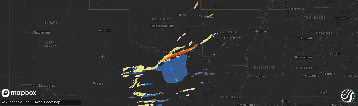
Hail Map on March 2, 2023
The weather event on March 2, 2023 includes Wind, Tornado, and Hail maps. 6 states and 473 cities were impacted and suffered possible damage. The total estimated number of properties impacted is 166,239.
Want more than just the map?
Turn this storm into a full workflow.
- Owner + property data so you know who to knock
- OnDemand branded weather history reports to win the "did we even have hail?" argument
- RoofTrace estimate so reps stop guessing numbers at the door
Bought this map? Upgrade within 7 days and we'll credit the $230. (10-15 min setup call)
Wind
Tornado
Hail
166,239
Estimated number of impacted properties by a 1.00" hail or larger57,746
Estimated number of impacted properties by a 1.75" hail or larger0
Estimated number of impacted properties by a 2.50" hail or largerStorm reports
Arkansas
| Date | Description |
|---|---|
| 03/02/202310:08 AM CST | Large limbs downed on parson road in the umpire community. |
| 03/02/202312:44 AM CST | Numerous trees and powerlines down northeast of carthage on highway 229. |
| 03/01/202311:13 PM CST | A recreational vehicle was crushed by a fallen tree. |
| 03/01/202311:05 PM CST | Shingles blown off a house in damascus. Multiple trees blown down across northern faulkner county. |
| 03/01/202311:05 PM CST | Trees downed along hwy. 67 west. |
| 03/01/202310:50 PM CST | Emergency manager reports 20 ro 30 homes in and around kirby damaged or destroyed. Several chicken houses were also destroyed and numerous trees were blown down. |
| 03/01/202310:42 PM CST | Trees downed near hwy. 27 south and 351. |
| 03/01/202310:08 PM CST | Corrects previous tstm wnd dmg report from 11 n dierks. Large limbs downed on parson road in the umpire community. |
| 03/01/20239:46 PM CST | Several trees and powerlines downed in and around dequeen... Arkansas. |
| 03/01/20239:06 PM CST | Numerous trees were reported down across the southern portion of scott county. |
| 03/01/20236:00 PM CST | Trees down across hwy 237 north of doddridge... Ar. Possible tornado damage. |
Oklahoma
| Date | Description |
|---|---|
| 03/02/20235:50 PM CST | Hail from pea to quarter size covering the ground near rufe. |
| 03/02/20235:45 PM CST | Tree uprooted with numerous other tree limbs/branches broken or damaged at raymond gary state park. |
| 03/02/20235:30 PM CST | A local report indicates 1.25 inch wind near 2 NW HUGO |
| 03/02/20234:28 PM CST | Spotter estimated winds on hwy 22. Post-storm damage investigations continue. |
| 03/02/20234:16 PM CST | Relayed report: power lines down and roof damage at dairy queen in caddo. |
| 03/02/20234:13 PM CST | Sheet metal and siding blown off barn. Time estimated by radar. |
| 03/02/20233:36 PM CST | Report from mping: quarter |
| 03/02/20233:35 PM CST | Outbuilding damaged on edge road. Power poles and one tree down in the lark road area. |
| 03/02/20233:34 PM CST | Report from mping: quarter |
| 03/02/202312:40 PM CST | A local report indicates 1.25 inch wind near MIAMI |
| 03/02/202312:37 PM CST | A local report indicates 1.75 inch wind near MIAMI |
| 03/02/202312:35 PM CST | Hail covered the ground. Also... Numerous small branches down. |
| 03/02/202312:26 PM CST | Emergency manager relayed report of 1.50 inch hail 2 miles south of narcissa. Time estimated by radar. |
| 03/01/20239:16 PM CST | A tree fell on a house along with privacy fence damage. |
| 03/01/20239:16 PM CST | A tree fell on a house along with privacy fence damage. |
Louisiana
| Date | Description |
|---|---|
| 03/02/20235:37 PM CST | Video of tornado in se shreveport near lsu-shreveport. Damage was reported at the college and near the intersection of youree dr and sophia lane. |
| 03/02/20231:59 AM CST | A tree was downed on highway 2 near dean road... Blocking one lane. |
| 03/02/20231:18 AM CST | Tree down on a home trapping the occupant. Believed to be uninjured. |
| 03/02/20231:04 AM CST | Tree over rich road and hwy 151. |
| 03/02/202312:42 AM CST | Tree down near heflin... Louisiana. |
| 03/02/202312:32 AM CST | Tree down on hwy. 516. |
| 03/02/202312:27 AM CST | Tree down on bistineau lake road. |
| 03/02/202312:20 AM CST | Large pine tree downed on hwy. 527 south of sligo road. |
| 03/02/202312:08 AM CST | Several trees downed across the entire parish. One tree fell on a home in mansfield... Louisiana. |
| 03/01/202311:35 PM CST | Tree down in backyard of house along camelback dr. |
| 03/01/202311:22 PM CST | Tree down on roy road near blanchard... Louisiana. |
Texas
| Date | Description |
|---|---|
| 03/02/20235:55 PM CST | 70 mph measured at nws office in north fort worth. |
| 03/02/20235:55 PM CST | Measured 80 mph at north tarrant parkway and riverside drive in north fort worth. |
| 03/02/20235:52 PM CST | Fort worth meacham asos measured 77 mph. |
| 03/02/20235:52 PM CST | Chimney was blown out to the side of the house. Detached garage/outbuilding had minor door damage. Time estimated by radar. |
| 03/02/20235:50 PM CST | Gust to 69 mph at denton enterprise airport asos. |
| 03/02/20235:45 PM CST | 70 mph measured at nas fort worth jrb. |
| 03/02/20235:45 PM CST | Update... 71 mph measured at nas fort worth jrb. |
| 03/02/20235:40 PM CST | Ham radio operator measured 68 mph on i-30 at the tarrant/parker county line. |
| 03/02/20235:40 PM CST | Business on camp bowie west lost its roof. |
| 03/02/20235:37 PM CST | Numerous trees down on county road 251. Possible tornado. |
| 03/02/20235:30 PM CST | Large tree down on fm road 1997 between marshall and jefferson. Tornado possible. |
| 03/02/20235:30 PM CST | Corrects previous tstm wnd dmg report from 7 s atlanta. Numerous trees down on county road 251. Also... Four homes with roof damage. Possible tornado. |
| 03/02/20235:20 PM CST | Roof damage at apartment complex in weatherford |
| 03/02/20235:20 PM CST | Roof damage to a house with significant damage to a detached building/garage. |
| 03/02/20235:16 PM CST | Cwop site. |
| 03/02/20235:11 PM CST | Trees on county road 1060. Possible tornado damage. |
| 03/02/20235:08 PM CST | Trees and powerlines down with roof damage to a mobile home. |
| 03/02/20235:06 PM CST | Telephone lines down on north side of menard on highway 83. Roof damage to three buildings. Several tree limbs down in the area. Possible collapse of an old building. |
| 03/02/20235:06 PM CST | Multi-vortex tornado spotted in northern franklin county west of talco and south of the sulphur river. |
| 03/02/20235:03 PM CST | Corrects previous non-tstm wnd dmg report from millsap. Fire station in millsap lost part of its roof. |
| 03/02/20235:02 PM CST | Mineral wells airport asos measured a gust to 71 mph. |
| 03/02/20235:00 PM CST | Considerable roof and building damage to magnolia on 4th apartment buildings. |
| 03/02/20234:58 PM CST | Trees on county road 1040. Likely tornado damage. |
| 03/02/20234:51 PM CST | Kjct asos rat the kimble county airport reported a 64 mph wind gust. |
| 03/02/20234:48 PM CST | Quarter hail in the community of palo pinto. |
| 03/02/20234:30 PM CST | Corrected time for wind damage report from menard. Telephone lines down on north side of menard on highway 83. Roof damage to three buildings. Several tree limbs down i |
| 03/02/20234:28 PM CST | Trained spotters observed a tornado in pickton. Roof damage to a house along state highway 11 at fm 269. Also downed trees and power lines. |
| 03/02/20234:22 PM CST | The west texas mesonet site located in menard measured a 73.4 mph gust. |
| 03/02/20234:22 PM CST | A local report indicates 73 MPH wind near 2 WNW MENARD |
| 03/02/20234:19 PM CST | Gusty winds and heavy rain have also created very limited visibility. Many drivers have pulled off to the side of the road. |
| 03/02/20234:12 PM CST | Half dollar hail. |
| 03/02/20234:10 PM CST | Damage to trees and outbuildings in necessity. |
| 03/02/20234:10 PM CST | A local report indicates 1.00 inch wind near 9 NE SILVER VALLEY |
| 03/02/20234:03 PM CST | Raws in hamby reported 64 mph gust with passing storms. |
| 03/02/20233:58 PM CST | Golf ball hail at intersection of u.s. Highway 75 and state highway 56 in sherman. |
| 03/02/20233:50 PM CST | A local report indicates 1.25 inch wind near 2 NE SOUTHMAYD |
| 03/02/20233:50 PM CST | San angelo asos reported gusts up to 58 mph at 350 pm local time. |
| 03/02/20233:40 PM CST | Damage to sheet metal roofs/carports in tioga |
| 03/02/20233:38 PM CST | Ping pong ball hail on fm 901 |
| 03/02/20233:37 PM CST | A local report indicates 65 MPH wind near 3 ENE ALBANY |
| 03/02/20233:37 PM CST | A local report indicates 60 MPH wind near 2 E WALL |
| 03/02/20233:37 PM CST | A local report indicates 65 MPH wind near 3 ENE ALBANY |
| 03/02/20233:35 PM CST | Golf ball hail along fm 922 just west of u.s. Highway 377. Estimated winds of 55-60 mph. |
| 03/02/20233:32 PM CST | Nickel to quarter hail in lake kiowa. |
| 03/02/20233:25 PM CST | Quarter-size hail in mountain springs. |
| 03/02/20233:20 PM CST | Skywarn spotter reported trees blown over onto power lines in abilene near the intersection of north treadway ave. And i-20. This caused a power outage. |
| 03/02/20233:18 PM CST | Quarter-size hail in valley view. |
| 03/02/20233:15 PM CST | Nickel to quarter hail. |
| 03/02/20233:13 PM CST | Quarter-size hail. |
| 03/02/20233:09 PM CST | Quarter-size hail. |
| 03/02/20233:05 PM CST | Ping pong ball hail 7 miles north of whitesboro. |
| 03/02/20233:00 PM CST | An 18-wheeler tipped over onto a pickup truck from high winds on highway 277. Time estimated from radar. |
| 03/02/20232:42 PM CST | Half dollar size hail was reported in decatur. |
| 03/02/202310:27 AM CST | Trees down countywide. |
| 03/02/20239:48 AM CST | Trees downed on the southeast side of the county. |
| 03/02/20237:15 AM CST | 58 mph wind gust approximately around 7:15 pm based on radar at the dripping springs north raws site. |
| 03/02/20236:08 AM CST | Report from mping: quarter |
| 03/02/20236:00 AM CST | A local report indicates 1.00 inch wind near 6 ESE WILLOW CITY |
| 03/01/202311:13 PM CST | Numerous trees downed across the entire county. The roof was removed from a local ace hardware store in timpson... Texas. Trees were downed on fm 947... 414 and 699. |
| 03/01/202311:00 PM CST | Numerous trees downed across the entire county. One tree was downed on a home on fm 2609 near nacogdoches... Texas. |
| 03/01/202310:51 PM CST | Recorded at remote automatic weather station |
| 03/01/202310:36 PM CST | Several trees downed near fm 1798 and county road 2174 near laneville... Texas. |
| 03/01/202310:30 PM CST | Corrects previous tstm wnd dmg report from 1 se jefferson. Trees down countywide. |
| 03/01/202310:30 PM CST | Lots of shingles removed... Trees down and one brick support blown away in the city of marshall. |
| 03/01/202310:27 PM CST | Trees down countywide. |
| 03/01/202310:24 PM CST | Numerous trees and powerlines downed across the entire county. |
| 03/01/20239:58 PM CST | Picture received from county em showing roof damage to a home near weches... Tx. Time is estimated based on radar. |
| 03/01/20239:52 PM CST | Young st... Mobberly st... Woodcrest ln... And willow oak drive. Numerous trees down. |
| 03/01/20239:47 PM CST | Large tree limbs down around town. Some metal roofing was pealed back from some structures. Photos provided by menard county em. |
| 03/01/20239:39 PM CST | Measured 64 mph wind gust on home weather station right along i-20. |
| 03/01/20239:30 PM CST | Corrects previous non-tstm wnd dmg report from 4 ene centerville. Several broken trees and large limbs down along hwy 7 near cr 203 east of centerville. |
| 03/01/20239:20 PM CST | Several trees and powerlines downed across the entire county. |
| 03/01/20239:16 PM CST | A tree was downed on a powerline in pittsburg... Texas on cr 1342. |
| 03/01/20239:15 PM CST | 58 mph wind gust reported at kenedy. |
| 03/01/20239:15 PM CST | Wind damage in centerville. Power pole down on a house... Multiple power lines and trees down. Time estimated. |
| 03/01/20239:10 PM CST | Trees downed in the northwest portion of the county. |
| 03/01/20239:08 PM CST | Picture received on twitter of a downed tree and a large tree limb down in tanglewood park. Time is estimated by radar. |
| 03/01/20239:06 PM CST | Picture on social media of a downed large oak tree onto a truck near copperfield park in bryan. Time is estimated based on radar. |
| 03/01/20238:55 PM CST | Tree down near cr 128 and fm 976 intersection. |
| 03/01/20238:42 PM CST | Report of trees downed along with power lines. Some structural damage reported as well along hwy 82. |
| 03/01/20238:33 PM CST | Several trees downed in and around the quitman... Texas area. |
| 03/01/20238:23 PM CST | 1 inch hail reported. |
| 03/01/20238:20 PM CST | Tree damage at hwy 77 and co. Rd. 232lp. Oak trees snapped and multiple 6 inch limbs broke along hwy 77. |
| 03/01/20238:20 PM CST | Large tree limb several inches in diameter snapped. |
| 03/01/20238:17 PM CST | Union pacific railroad |
| 03/01/20238:15 PM CST | Report from mping quarter |
| 03/01/20238:13 PM CST | Report from mping 3-inch tree limbs broken; power poles broken. |
| 03/01/20238:10 PM CST | 1 inch hail reported at lackland air force base. |
| 03/01/20237:59 PM CST | Corsicana municipal airport |
| 03/01/20237:55 PM CST | Report from mping 3-inch tree limbs broken; power poles broken. |
| 03/01/20237:53 PM CST | Gust to 60 mph reported at kelly field. |
| 03/01/20237:51 PM CST | Gust of 58 mph reported at the san antonio airport. |
| 03/01/20237:50 PM CST | Reported tree down. |
| 03/01/20237:41 PM CST | A local report indicates 58 MPH wind near AUSTIN BERGSTROM INTL A |
| 03/01/20237:35 PM CST | Gvt awos. |
| 03/01/20237:32 PM CST | Report from mping 3-inch tree limbs broken power poles broken. |
| 03/01/20237:31 PM CST | Report from mping 3-inch tree limbs broken power poles broken. |
| 03/01/20237:30 PM CST | Reports of multiple old brick buildings collapsed in greenville. Time estimated from radar. |
| 03/01/20237:26 PM CST | Gust of 59 mph reported. |
| 03/01/20237:20 PM CST | Roof damage to city hall in honey grove. |
| 03/01/20237:15 PM CST | Terrell municipal airport measured 65 mph. |
| 03/01/20237:15 PM CST | Corrects previous tstm wnd gst report from 2 n dripping springs. 58 mph wind gust approximately around 7:15 pm based on radar at the dripping springs north raws site. |
| 03/01/20237:10 PM CST | Damage to buildings in celeste |
| 03/01/20237:10 PM CST | A local report indicates 61 MPH wind near 6 N LEONARD |
| 03/01/20237:10 PM CST | Large section of a tree down in killeen near n college st and w avenue b. Time estimated by radar. |
| 03/01/20237:10 PM CST | Measured 74 mph on the west side of terrell. |
| 03/01/20237:08 PM CST | Estimated 60 mph in caddo mills |
| 03/01/20236:45 PM CST | A local report indicates 68 MPH wind near GARLAND |
| 03/01/20236:45 PM CST | Semi truck blew over and blocked westbound lanes of i-20 in se dallas. |
| 03/01/20236:45 PM CST | Measured 71 mph at u.s. Highway 75 and county line road on the far south side of van alstyne. |
| 03/01/20236:42 PM CST | Mckinney national airport asos measured 64 mph. |
| 03/01/20236:41 PM CST | Multiple power poles laying down on south side along srt and state hwy 121. |
| 03/01/20236:41 PM CST | Multiple 3 inch and larger tree limbs broken and thrown throughout parking lot. Steel cart corrals moved more than 20 from original site. |
| 03/01/20236:40 PM CST | Damage to businesses at preston road and w. Park blvd. |
| 03/01/20236:40 PM CST | Gust of 62 mph reported. |
| 03/01/20236:34 PM CST | Dallas love field asos measured 76 mph. |
| 03/01/20236:34 PM CST | Dallas executive airport asos measured 63 mph. |
| 03/01/20236:28 PM CST | Arlington municipal airport measured 58 mph. |
| 03/01/20236:25 PM CST | Update... Dfw airport asos measured 71 mph. |
| 03/01/20236:25 PM CST | Partial building collapse at little elm shopping center |
| 03/01/20236:15 PM CST | Dfw airport asos measured 67 mph. |
| 03/01/20236:06 PM CST | Fort worth alliance asos measured 61 mph. |
| 03/01/20236:05 PM CST | Apartment buildling in hurst lost its roof. |
| 03/01/20236:05 PM CST | Semi truck blew over and blocked westbound lanes of ne loop 820. |
| 03/01/20236:00 PM CST | Damage to new or under construction homes in north richland hills. Time estimated by radar. |
Cities Impacted by Hail Map on March 2, 2023
- Fayetteville, AR
- Elkins, AR
- Hindsville, AR
- Huntsville, AR
- Round Mountain, TX
- Johnson City, TX
- Afton, OK
- Fairland, OK
- Miami, OK
- Commerce, OK
- Quapaw, OK
- Picher, OK
- Poolville, TX
- Bridgeport, TX
- Paradise, TX
- Decatur, TX
- Gainesville, TX
- Valley View, TX
- Roby, TX
- Sylvester, TX
- McCaulley, TX
- Krum, TX
- Whitesboro, TX
- Sanger, TX
- Trent, TX
- Merkel, TX
- Abilene, TX
- Sadler, TX
- Gordonville, TX
- Clyde, TX
- Roscoe, TX
- Sweetwater, TX
- Pottsboro, TX
- Anson, TX
- Hawley, TX
- Albany, TX
- Lueders, TX
- Baird, TX
- Collinsville, TX
- Tioga, TX
- Pilot Point, TX
- Kingston, OK
- Howe, TX
- Sherman, TX
- Moran, TX
- Denison, TX
- Talpa, TX
- Valera, TX
- Coleman, TX
- Cisco, TX
- Breckenridge, TX
- Ranger, TX
- Bells, TX
- Durant, OK
- Caddo, OK
- Caddo, TX
- Savoy, TX
- Hendrix, OK
- Burkett, TX
- Ravenna, TX
- Caney, OK
- Bonham, TX
- Ivanhoe, TX
- Bokchito, OK
- Telephone, TX
- Strawn, TX
- Graford, TX
- Menard, TX
- Brady, TX
- Milburn, OK
- Kenefic, OK
- Stamford, TX
- Mcalester, OK
- Rowena, TX
- Paint Rock, TX
- Pittsburg, KS
- Mindenmines, MO
- Vinita, OK
- Nolan, TX
- Weir, KS
- Columbus, KS
- Galena, KS
- Scammon, KS
- Colbert, OK
- Ballinger, TX
- Blackwell, TX
- Maryneal, TX
- Hamlin, TX
- Rotan, TX
- Mead, OK
- Era, TX
- Avoca, TX
- Novice, TX
- Coalgate, OK
- Centrahoma, OK
- Voss, TX
- Calvin, OK
- Stuart, OK
- Springtown, TX
- Baxter Springs, KS
- Asbury, MO
- Weatherford, TX
- Rosston, TX
- Muenster, TX
- Alvord, TX
- Seymour, TX
- Honey Grove, TX
- Bennington, OK
- Sumner, TX
- Palo Pinto, TX
- Mineral Wells, TX
- Boswell, OK
- Arthur City, TX
- Santa Anna, TX
- Bangs, TX
- Brownwood, TX
- Millsap, TX
- Santo, TX
- Jefferson, TX
- Hugo, OK
- Rocksprings, TX
- Junction, TX
- Marshall, TX
- Melvin, TX
- Lohn, TX
- Rochelle, TX
- Voca, TX
- Grant, OK
- Powderly, TX
- Fort Towson, OK
- Sawyer, OK
- Spencerville, OK
- Aledo, TX
- Azle, TX
- Perrin, TX
- Fort Worth, TX
- Naval Air Station Jrb, TX
- Crowley, TX
- Haslet, TX
- Keller, TX
- Burleson, TX
- Haltom City, TX
- Valliant, OK
- Rufe, OK
- Atlanta, TX
- Early, TX
- Bloomburg, TX
- Blanket, TX
- Zephyr, TX
- Doddridge, AR
- Ringold, OK
- Comanche, TX
- Dublin, TX
- Gustine, TX
- Justin, TX
- Rhome, TX
- Newark, TX
- Denton, TX
- Argyle, TX
- Ponder, TX
- Kennedale, TX
- Roanoke, TX
- North Richland Hills, TX
- Hurst, TX
- Grapevine, TX
- Flower Mound, TX
- Aubrey, TX
- Colleyville, TX
- Lewisville, TX
- Lake Dallas, TX
- Bedford, TX
- Arlington, TX
- Southlake, TX
- Alvarado, TX
- Euless, TX
- Mansfield, TX
- Little Elm, TX
- Coppell, TX
- Dallas, TX
- Lillian, TX
- Grand Prairie, TX
- Venus, TX
- Irving, TX
- Midlothian, TX
- Desoto, TX
- Waxahachie, TX
- Frisco, TX
- Carrollton, TX
- Duncanville, TX
- Red Oak, TX
- The Colony, TX
- Cedar Hill, TX
- Prosper, TX
- Addison, TX
- Plano, TX
- Celina, TX
- Mckinney, TX
- Fouke, AR
- Texarkana, AR
- Broken Bow, OK
- Fredericksburg, TX
- Willow City, TX
- Mason, TX
- San Saba, TX
- Cherokee, TX
- Lometa, TX
- Bend, TX
- Lampasas, TX
- Llano, TX
- Kingsland, TX
- Buchanan Dam, TX
- Burnet, TX
- Marble Falls, TX
- Hutchins, TX
- Lancaster, TX
- Allen, TX
- Palmer, TX
- Richardson, TX
- Ferris, TX
- Hunt, TX
- Ingram, TX
- Kerrville, TX
- Comfort, TX
- Center Point, TX
- Boerne, TX
- Sachse, TX
- Princeton, TX
- Farmersville, TX
- Royse City, TX
- Lavon, TX
- Crandall, TX
- Wilmer, TX
- Forney, TX
- Rowlett, TX
- Seagoville, TX
- Blue Ridge, TX
- Nevada, TX
- Balch Springs, TX
- Mesquite, TX
- Wylie, TX
- Scurry, TX
- Anna, TX
- Melissa, TX
- Sunnyvale, TX
- Garland, TX
- Terrell, TX
- Kaufman, TX
- Rockwall, TX
- Joshua, TX
- Cleburne, TX
- Itasca, TX
- Godley, TX
- Grandview, TX
- Covington, TX
- Keene, TX
- Maypearl, TX
- Rio Vista, TX
- Kempner, TX
- Copperas Cove, TX
- Blum, TX
- Ennis, TX
- Fort Hood, TX
- Blanco, TX
- Stonewall, TX
- Hye, TX
- Bertram, TX
- Liberty Hill, TX
- Florence, TX
- Milford, TX
- Italy, TX
- Forreston, TX
- Ector, TX
- Whitewright, TX
- Trenton, TX
- Randolph, TX
- Wimberley, TX
- Dripping Springs, TX
- Bandera, TX
- Hondo, TX
- Georgetown, TX
- Mico, TX
- Pipe Creek, TX
- Helotes, TX
- Rosser, TX
- Leonard, TX
- Quinlan, TX
- Caddo Mills, TX
- Van Alstyne, TX
- Greenville, TX
- Celeste, TX
- Wolfe City, TX
- Carlton, TX
- Windom, TX
- Bailey, TX
- Ladonia, TX
- Dodd City, TX
- Granger, TX
- San Antonio, TX
- Bulverde, TX
- Spring Branch, TX
- Fischer, TX
- Driftwood, TX
- Canyon Lake, TX
- Commerce, TX
- Wills Point, TX
- Campbell, TX
- Shreveport, LA
- Manor, TX
- Leander, TX
- Austin, TX
- Mena, AR
- San Marcos, TX
- Hatfield, AR
- Pflugerville, TX
- Round Rock, TX
- Coupland, TX
- Taylor, TX
- Thorndale, TX
- Buckholts, TX
- La Coste, TX
- Castroville, TX
- Jbsa Lackland, TX
- Atascosa, TX
- Boles, AR
- Von Ormy, TX
- Jbsa Ft Sam Houston, TX
- Rockdale, TX
- Cameron, TX
- Davilla, TX
- Parks, AR
- Hillsboro, TX
- Whitney, TX
- Malone, TX
- Abbott, TX
- Bynum, TX
- Mertens, TX
- Hubbard, TX
- Blooming Grove, TX
- Frost, TX
- Purdon, TX
- Barry, TX
- Rice, TX
- Corsicana, TX
- Malakoff, TX
- Powell, TX
- Kemp, TX
- Eustace, TX
- Mabank, TX
- Kerens, TX
- Chatfield, TX
- Trinidad, TX
- Converse, TX
- Athens, TX
- Canton, TX
- Fruitvale, TX
- Point, TX
- Lone Oak, TX
- Pecan Gap, TX
- Cumby, TX
- Ben Wheeler, TX
- Emory, TX
- Grand Saline, TX
- Murchison, TX
- Van, TX
- Alba, TX
- Klondike, TX
- Brownsboro, TX
- Edgewood, TX
- Penelope, TX
- Richland, TX
- Dawson, TX
- Saint Hedwig, TX
- Adkins, TX
- Schertz, TX
- Jbsa Randolph, TX
- Wortham, TX
- Streetman, TX
- Cibolo, TX
- Marion, TX
- Seguin, TX
- Yantis, TX
- Roxton, TX
- Brookston, TX
- Paris, TX
- Cooper, TX
- Petty, TX
- Enloe, TX
- Brashear, TX
- Sulphur Springs, TX
- Ben Franklin, TX
- Gravelly, AR
- Bluffton, AR
- Harvey, AR
- Danville, AR
- Castell, TX
- Watson, OK
- Cove, AR
- Throckmorton, TX
- Woodson, TX
- Snow, OK
- Rattan, OK
- Nashoba, OK
- Gouldbusk, TX
- Spicewood, TX
- Horseshoe Bay, TX
- Doss, TX
- Harper, TX
- Cross Plains, TX
- Eden, TX
- Madill, OK
- Belton, TX
- Temple, TX
- Waldron, AR
- Smithville, OK
- Mountain Home, TX
- Fredonia, TX
- Pontotoc, TX
- Wright City, OK
- Graham, TX
- Gunter, TX
- Coleman, OK
- Cartwright, OK
- Calera, OK
- Antlers, OK
- Lane, OK
- Atoka, OK
- Winona, TX
- Kilgore, TX
- Gladewater, TX
- Longview, TX
- White Oak, TX
- Hallsville, TX
- Karnack, TX
- Garrison, TX
- Timpson, TX
- Donaldson, AR
- Malvern, AR
- Altheimer, AR
- Hazen, AR
- Briggsville, AR
- New Braunfels, TX
- Crockett, TX
- Grapeland, TX
- Ola, AR
- Plainview, AR
- Alto, TX
- Kennard, TX
- Centerville, TX
- Oakwood, TX
- Buffalo, TX
- Falls City, TX
- Poth, TX
- Franklin, TX
- Hope, AR
- Luling, TX
- Kingsbury, TX
- Lovelady, TX
- Midway, TX
- Mount Enterprise, TX
- Elmendorf, TX
- Ashdown, AR
- Wilton, AR
- Leesville, TX
- Gonzales, TX
- Universal City, TX
- McQueeney, TX
- La Vernia, TX
- Stockdale, TX
- Wabbaseka, AR
- Jewett, TX
- Marquez, TX
- Wells, TX
- North Zulch, TX