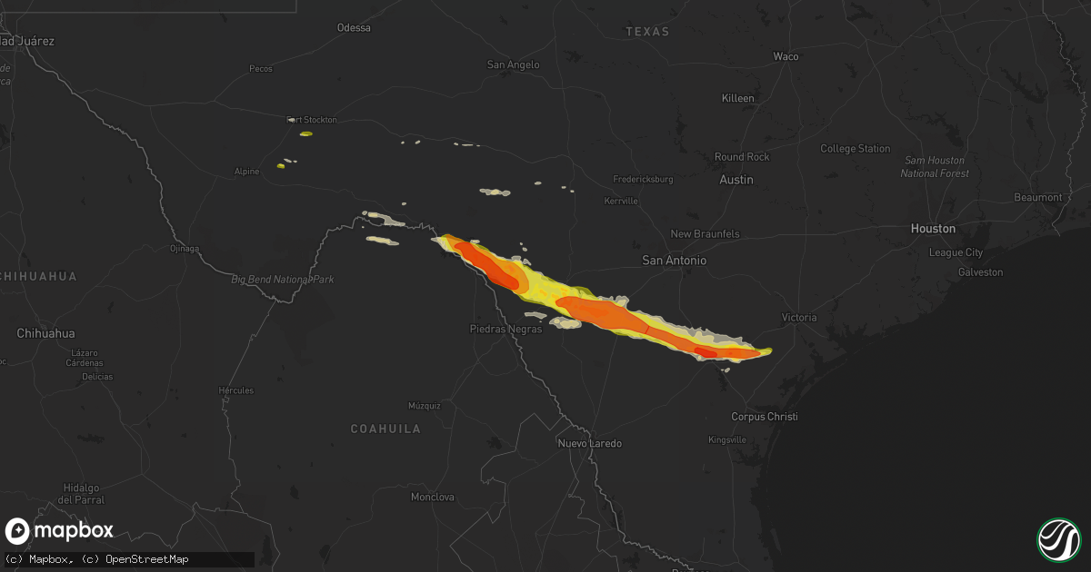
Hail Map on February 22, 2016
Get this storm
February 22 map
$229
one time, instant access
Download today. No call, no setup
Keep the $229
Bought the map and want the full workflow? Apply the entire $229 to a subscription within 7 days. None of it is wasted.
Every map, not just this one
This buys you this map. Subscription and you get every map we run, in the markets you choose from a few cities to whole states to nationwide. Plus real-time alerts the moment a storm fires.
Contact data
Name, contact info, occupancy, even credit band for addresses in the footprint. You go from where it hit to who to call.
Become the source they trust
Unlimited branding weather history reports on demand. You already have the documented answer ready for the property owner, and you are the one who showed up with it.
Property data and RoofTrace estimates
Pull up any address you have got, its value and the exact code rules for that jurisdiction, straight from One Click Code. Then RoofTrace estimates the squares, pitch, and roof value, priced the way you price.
States Impacted by Hail Map on February 22, 2016
Storm reports
Texas
| Date | Description |
|---|---|
| 02/22/20165:40 AM CST | Damage to 4 residences. Trees and powerlines downed. Cr100 blocked by debris. |
| 02/22/20162:45 AM CST | 10 power pole lines broken on i-37. Reported by nws employee on way to san antonio. |
| 02/22/20162:26 AM CST | Spotter reported golf ball sized hail at the hospital in beeville near highway 181 and 59. |
| 02/22/20162:26 AM CST | Trees and power lines reported down over the eastern portions of the city of beeville. Wind driven hail also broke windows at the hospital and some businesses. |
| 02/22/20161:42 AM CST | Relayed from san antonio broadcast media market. Near texas road 72. |
| 02/22/20161:05 AM CST | Quarter size hail observed briefly sw of charlotte. Nickel size for 3-4 minutes. |
| 02/22/201612:58 AM CST | Quarter sized hail reported in the city of la pryor on media facebook page. |
| 02/22/201612:36 AM CST | At least quarter size hail observed at gas station along i-35 |
| 02/21/201611:56 PM CST | At least quarter size hail observed in la pryor. |
| 02/21/201611:39 PM CST | A local report indicates 66 MPH wind near 1 WNW BIG LAKE |
| 02/21/201611:25 PM CST | A local report indicates 58 MPH wind near 5 SW ST. LAWRENCE |
| 02/21/201611:10 PM CST | Golf ball size hail reported in spofford. |
| 02/21/201611:05 PM CST | Golf ball size hail caused damage to house and car windows and roof shingles across town. |
| 02/21/201611:03 PM CST | Pictures of quarter to ping pong size hail and car wind shields damaged in bracketville. |
| 02/21/201610:35 PM CST | Quarter size hail observed by military personnel. |
| 02/21/201610:32 PM CST | 60 mph wind gust measured by asos |
| 02/21/201610:25 PM CST | Ping pong size hail reported in north del rio |
| 02/21/201610:25 PM CST | Windows blown out of house...ground also covered in quarter size hail. |
| 02/21/201610:25 PM CST | Quarter size hail observed by public at corner of veterans blvd and 15th st. |
| 02/21/20168:25 PM CST | A local report indicates 1.00 inch wind near 7 S DRYDEN |
Alabama
| Date | Description |
|---|---|
| 02/21/201611:00 PM CST | Roof damage to some homes in the rehobeth area. |
New Mexico
| Date | Description |
|---|---|
| 02/22/20163:30 PM CST | White sands missile range - zumwalt track. |
Cities Impacted by Hail Map on February 22, 2016
- Crystal City, TX
- La Pryor, TX
- George West, TX
- Three Rivers, TX
- Beeville, TX
- Del Rio, TX
- Rocksprings, TX
- Calliham, TX
- Quemado, TX
- Brackettville, TX
- Dryden, TX
- Batesville, TX
- Uvalde, TX
- Odonnell, TX
- Lamesa, TX
- Tahoka, TX
- Welch, TX
- Comstock, TX
- Fort Stockton, TX
- Laughlin Afb, TX
- Aspermont, TX
- Ozona, TX
- Jourdanton, TX
- Goliad, TX
- Dilley, TX
- Charlotte, TX
- Fowlerton, TX
- Pearsall, TX
- Cotulla, TX
- Tilden, TX
- Campbellton, TX
- Whitsett, TX
- Kenedy, TX
- Moore, TX
- Mathis, TX
- Skidmore, TX
- Refugio, TX
- Eagle Pass, TX
- Sabinal, TX