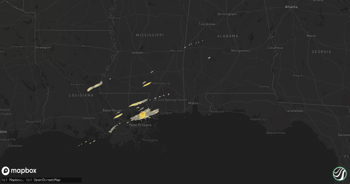
Hail Map on February 22, 2013
Get this storm
February 22 map
$229
one time, instant access
Download today. No call, no setup
Keep the $229
Bought the map and want the full workflow? Apply the entire $229 to a subscription within 7 days. None of it is wasted.
Every map, not just this one
This buys you this map. Subscription and you get every map we run, in the markets you choose from a few cities to whole states to nationwide. Plus real-time alerts the moment a storm fires.
Contact data
Name, contact info, occupancy, even credit band for addresses in the footprint. You go from where it hit to who to call.
Become the source they trust
Unlimited branding weather history reports on demand. You already have the documented answer ready for the property owner, and you are the one who showed up with it.
Property data and RoofTrace estimates
Pull up any address you have got, its value and the exact code rules for that jurisdiction, straight from One Click Code. Then RoofTrace estimates the squares, pitch, and roof value, priced the way you price.
States Impacted by Hail Map on February 22, 2013
Storm reports
Mississippi
| Date | Description |
|---|---|
| 02/22/20135:55 PM CST | Along gates rd |
| 02/22/20135:53 PM CST | Occurred on park ave. |
| 02/22/20131:47 PM CST | A local report indicates 1.00 inch wind near 2 NW ROXIE |
| 02/22/20131:35 PM CST | Quarter sized hail reported in kingston community by emergency manager. |
| 02/22/20131:13 PM CST | Nickel to quarter size hail covering patio |
| 02/21/20136:13 PM CST | Reports of dime to quarter size hail in sumrall. |
Louisiana
| Date | Description |
|---|---|
| 02/21/201310:25 PM CST | A local report indicates 1.00 inch wind near SLIDELL |
| 02/21/201310:07 PM CST | Report from the hickory area. |
| 02/21/20139:55 PM CST | A local report indicates 1.75 inch wind near LACOMBE |
| 02/21/20139:48 PM CST | Spotter reports quarter sized hail in the city of bogalusa. |
| 02/21/20139:40 PM CST | A local report indicates 1.00 inch wind near 10 S MANDEVILLE |
Cities Impacted by Hail Map on February 22, 2013
- Acme, LA
- Vidalia, LA
- Marksville, LA
- Woodville, MS
- Monterey, LA
- Livingston, AL
- Lacombe, LA
- Saint Amant, LA
- Prairieville, LA
- Livingston, LA
- Gonzales, LA
- French Settlement, LA
- Geismar, LA
- Pearl River, LA
- Stennis Space Center, MS
- Columbia, MS
- Covington, LA
- Folsom, LA
- Loranger, LA
- Kiln, MS
- Gilbertown, AL
- Toxey, AL
- Needham, AL
- Butler, AL
- Cuba, AL
- Bogalusa, LA
- Bush, LA
- Poplarville, MS
- Tickfaw, LA
- Independence, LA
- Franklinton, LA
- Wiggins, MS
- Forkland, AL
- Mansura, LA
- Edgard, LA
- Reserve, LA
- Slidell, LA
- Mandeville, LA
- Greensboro, AL
- Bay Saint Louis, MS
- Napoleonville, LA
- Denham Springs, LA
- Baton Rouge, LA
- Foxworth, MS
- Kokomo, MS
- New Orleans, LA
- Valley, AL
- Abita Springs, LA
- Brooklyn, MS
- Lumberton, MS
- Collins, MS
- Roxie, MS
- Donaldsonville, LA
- York, AL
- Saint James, LA
- Convent, LA
- Sumrall, MS
- Mount Olive, MS
- Patterson, LA
- Pierre Part, LA
- Morgan City, LA
- West Point, GA
- Picayune, MS
- Moselle, MS
- Hattiesburg, MS