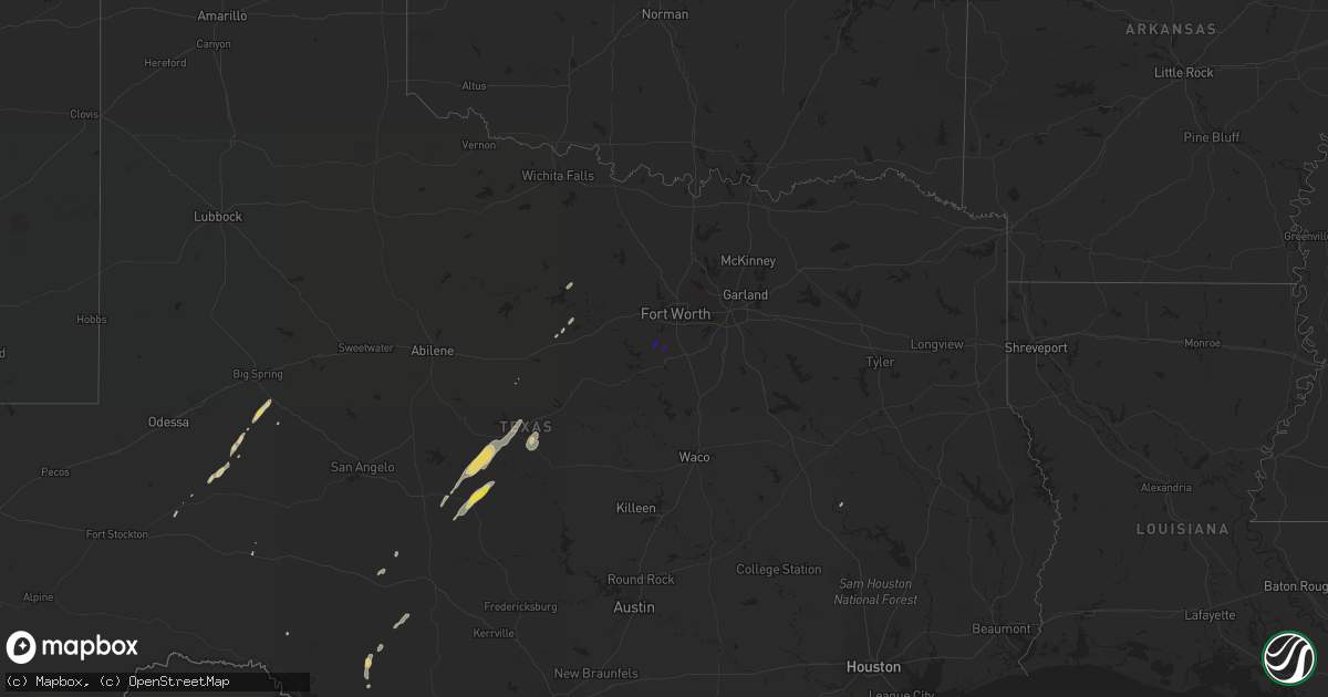
Hail Map on February 20, 2018
Get this storm
February 20 map
$229
one time, instant access
Download today. No call, no setup
Keep the $229
Bought the map and want the full workflow? Apply the entire $229 to a subscription within 7 days. None of it is wasted.
Every map, not just this one
This buys you this map. Subscription and you get every map we run, in the markets you choose from a few cities to whole states to nationwide. Plus real-time alerts the moment a storm fires.
Contact data
Name, contact info, occupancy, even credit band for addresses in the footprint. You go from where it hit to who to call.
Become the source they trust
Unlimited branding weather history reports on demand. You already have the documented answer ready for the property owner, and you are the one who showed up with it.
Property data and RoofTrace estimates
Pull up any address you have got, its value and the exact code rules for that jurisdiction, straight from One Click Code. Then RoofTrace estimates the squares, pitch, and roof value, priced the way you price.
States Impacted by Hail Map on February 20, 2018
Storm reports
Tennessee
| Date | Description |
|---|---|
| 02/20/20185:36 AM CST | At 1133 PM CST, a severe thunderstorm was located over Risco, or 8 miles northwest of Portageville, moving northeast at 55 mph. HAZARD...60 mph wind gusts. SOURCE...Radar indicated. IMPACT...Expect damage to roofs, siding, and trees. Locations impacted include... Portageville, New Madrid, Lilbourn, Hunter-Dawson State Historic Site, Malden, Gideon, Parma, Matthews, Marston, Howardville, Risco, Farrenburg, Tallapoosa, Catron and North Lilbourn. |
Arkansas
| Date | Description |
|---|---|
| 02/20/20185:45 PM CST | Thunderstorm winds damaged 4 hog buildings... Removed the roof of 3 chicken houses and debris knocked the windows out of one vehicle. |
| 02/20/20185:12 PM CST | Tree in nw dequeen fell... Landing on a car. The dequeen asos reported a gust to 44 mph at 510 pm. |
| 02/20/20185:10 PM CST | Several trees are down and tangled with power lines along hwy 24 west of horatio. Dequeen asos reported a gust to 44 mph at 510 pm. |
| 02/20/20185:23 AM CST | At 1123 PM CST, a severe thunderstorm was located over Kennett, moving northeast at 60 mph. HAZARD...60 mph wind gusts. SOURCE...Radar indicated. IMPACT...Expect damage to roofs, siding, and trees. Locations impacted include... Kennett, Malden, Portageville, Senath, Clarkton, Holcomb, Wardell, Deering, Bolton, Bragg City, Pascola, Nimmons, Lorine, West Kennett, Bell City, Noland, Carryville, North Wardell, White Oak and Homestown. |
| 02/20/20184:29 AM CST | At 1029 PM CST, a severe thunderstorm was located near Corning, moving northeast at 55 mph. HAZARD...60 mph wind gusts. SOURCE...Radar indicated. IMPACT...Expect damage to roofs, siding, and trees. This severe thunderstorm will remain over mainly rural areas of north central Clay County. |
| 02/19/201811:10 PM CST | 1 grain bin toppled and 9 utility poles broken |
| 02/19/201810:55 PM CST | Lots of roof shingles removed from a house. |
| 02/19/20189:50 PM CST | Roof off barn |
| 02/19/20189:21 PM CST | Chicken house roofs were damaged and removed. Outbuildings were damaged. The damage was consistent with straight-line winds in excess of 70 mph. |
| 02/19/20189:14 PM CST | Several outbuildings were damaged. Some trees were blown down. The damage was consistent with straight-line winds of 60-80 mph. |
Indiana
| Date | Description |
|---|---|
| 02/20/20183:32 AM CST | Grill toppled... A couple of trees down... Lawn swing tipped over. Time approximate from radar. |
Texas
| Date | Description |
|---|---|
| 02/20/20187:30 AM CST | The brownwood police department reported businesses with broken out windows... And roof damage to a few sheds. |
| 02/19/20187:27 PM CST | At 126 AM CST, severe thunderstorms were located along a line extending from near Placid to 6 miles northwest of Pontotoc, moving northeast at 50 mph. HAZARD...60 mph wind gusts and quarter size hail. SOURCE...Radar indicated. IMPACT...Hail damage to vehicles is expected. Expect wind damage to roofs, siding, and trees. Severe thunderstorms will be near, Mercury around 135 AM CST. Winchell around 140 AM CST. Elm Grove and Skeeterville around 145 AM CST. San Saba around 155 AM CST. Bend around 200 AM CST. Other locations impacted by these severe thunderstorms includeHarkeyville, US-190 Near The McCulloch-San Saba County Line, Fife, Milburn, Locker, Whon, Spring Creek,Hall, Indian Creek and US-283 Near The McCulloch-Coleman County Line. |
| 02/19/20187:11 PM CST | At 110 PM CST, a severe thunderstorm was located near Brady, moving northeast at 35 mph. HAZARD...60 mph wind gusts and quarter size hail. SOURCE...Radar indicated. IMPACT...Hail damage to vehicles is expected. Expect wind damage to roofs, siding, and trees. This severe thunderstorm will be near, Rochelle around 120 PM CST. Placid around 130 PM CST. Mercury around 140 PM CST. Elm Grove around 145 PM CST. Other locations impacted by this severe thunderstorm include Milburn. |
Illinois
| Date | Description |
|---|---|
| 02/20/20181:04 PM CST | Trees were blown down. Time estimated. |
Missouri
| Date | Description |
|---|---|
| 02/20/20185:05 AM CST | At 1104 PM CST, a severe thunderstorm was located over Bay, moving northeast at 55 mph. HAZARD...60 mph wind gusts. SOURCE...Radar indicated. IMPACT...Expect damage to roofs, siding, and trees. Locations impacted include... Jonesboro, Paragould, Trumann, Lake City, Leachville, Bay, Brookland, Monette, Cardwell, Hornersville, Arbyrd, Black Oak, Jolliff Store, Apt, Delfore, Carmi, Gum Point, Whisp, Farrville and Buckeye. |
| 02/20/20184:41 AM CST | At 1040 PM CST, a severe thunderstorm was located over Paragould, moving northeast at 55 mph. HAZARD...60 mph wind gusts. SOURCE...Radar indicated. IMPACT...Expect damage to roofs, siding, and trees. Locations impacted include... Paragould, Kennett, Malden, Piggott, Campbell, Rector, Senath, Marmaduke, Chalk Bluff Natural Area, Clarkton, Oak Grove Heights, Cardwell, Holcomb, Arbyrd, Lafe, St. Francis, Pollard, Greenway, McDougal and Glennonville. |
| 02/19/201811:07 PM CST | Asos measured. |
| 02/19/201810:59 PM CST | Asos measured. |
Kentucky
| Date | Description |
|---|---|
| 02/20/20184:32 AM CST | One tree downed. |
Cities Impacted by Hail Map on February 20, 2018
- Blanket, TX
- Early, TX
- Junction, TX
- Menard, TX
- Garden City, TX
- Brady, TX
- Rochelle, TX
- Lohn, TX
- Santa Anna, TX
- Brookesmith, TX
- Rockwood, TX
- Bangs, TX
- Brownwood, TX
- Midkiff, TX
- Big Lake, TX
- Graford, TX
- Zephyr, TX
- Mullin, TX
- Grulla, TX
- Sullivan City, TX
- Rio Grande City, TX
- Rocksprings, TX
- Melvin, TX
- Brackettville, TX
- Strawn, TX
- Gordon, TX
- Palo Pinto, TX
- Crockett, TX
- May, TX
- Ozona, TX
- Sonora, TX
- Godley, TX
- Joshua, TX
- Desoto, TX