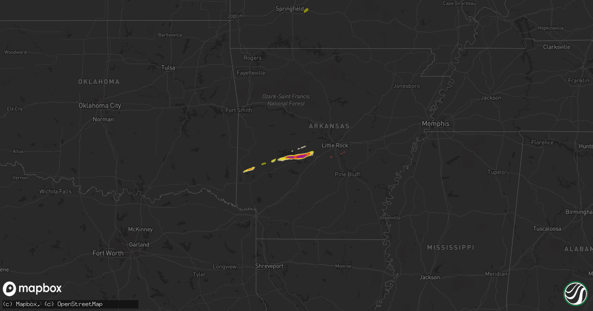
Hail Map on February 9, 2024
Get this storm
February 9 map
$229
one time, instant access
Download today. No call, no setup
Keep the $229
Bought the map and want the full workflow? Apply the entire $229 to a subscription within 7 days. None of it is wasted.
Every map, not just this one
This buys you this map. Subscription and you get every map we run, in the markets you choose from a few cities to whole states to nationwide. Plus real-time alerts the moment a storm fires.
Contact data
Name, contact info, occupancy, even credit band for addresses in the footprint. You go from where it hit to who to call.
Become the source they trust
Unlimited branding weather history reports on demand. You already have the documented answer ready for the property owner, and you are the one who showed up with it.
Property data and RoofTrace estimates
Pull up any address you have got, its value and the exact code rules for that jurisdiction, straight from One Click Code. Then RoofTrace estimates the squares, pitch, and roof value, priced the way you price.
Storm reports
Indiana
| Date | Description |
|---|---|
| 02/09/20244:04 AM CST | Multiple trees damaged and power lines down near taft road east of new washington. Time estimated from radar. |
| 02/09/20243:48 AM CST | Corrects previous tstm wnd dmg report from 1 nw henryville. Semi-truck blown over on interstate 65 northbound near underwood. Time estimated from radar. |
| 02/09/20243:44 AM CST | Report of trees and power lines down along us 31 north of henryville. Time estimated from radar. |
| 02/09/20243:42 AM CST | Semi-truck blown over on interstate 65 northbound just north of henryville. Time estimated from radar. |
Illinois
| Date | Description |
|---|---|
| 02/09/20241:12 AM CST | Hail up to quarter size covering the ground. Report relayed by kfvs 12. Time estimated by radar. |
| 02/09/20241:09 AM CST | Pea to quarter size hail covering the ground. Time estimated by radar. |
| 02/09/202412:40 AM CST | Dime to quarter sized hail. |
| 02/09/202412:20 AM CST | Social media report of quarter size hail. |
Kentucky
| Date | Description |
|---|---|
| 02/09/20245:10 AM CST | Corrects previous tstm wnd gst report from 5 e owenton. |
Arkansas
| Date | Description |
|---|---|
| 02/09/20245:40 PM CST | A local report indicates 2.00 inch wind near 2 NE Gulpha Gorge |
| 02/09/20245:32 PM CST | Time estimated via radar. |
| 02/09/20245:16 PM CST | Mping report. |
| 02/09/20245:15 PM CST | A local report indicates 1.50 inch wind near Royal |
| 02/08/20246:49 PM CST | Several trees uprooted along east sardis road. Possible tornado. Time based on radar. |
Cities Impacted by Hail Map on February 9, 2024
- Oklahoma City, OK
- Wickes, AR
- Grannis, AR
- Umpire, AR
- Dierks, AR
- Norman, AR
- Caddo Gap, AR
- Mount Ida, AR
- Royal, AR
- Hot Springs National Park, AR
- Mountain Pine, AR
- Hot Springs Village, AR
- Lonsdale, AR
- Benton, AR
- Mabelvale, AR
- Hensley, AR
- England, AR
- Fordland, MO
- Seymour, MO
- Fruitvale, TX
- Edgewood, TX
- Bonnerdale, AR
- Chester, IL
- Steeleville, IL
- Saint Mary, MO
- Perryville, MO
- Walsh, IL
- Sainte Genevieve, MO
- Percy, IL
- Campbell Hill, IL
- Ava, IL
- Du Quoin, IL
- Pinckneyville, IL
- Vergennes, IL
- Ellis Grove, IL
- Mulkeytown, IL
- Benton, IL
- Christopher, IL
- Whittington, IL
- Ewing, IL
- Macedonia, IL
- Thompsonville, IL
- Wadesville, IN
- New Harmony, IN
- Mount Vernon, IN
- Evansville, IN
- Jessieville, AR
- Royalton, IL
- Buckner, IL
- Carmi, IL
- Rockwood, IL
- Dowell, IL
- Cutler, IL
- Elkville, IL
- Sparta, IL
- Orleans, IN
- Salem, IN
- Campbellsburg, IN
- Paoli, IN
- West Baden Springs, IN
- Sesser, IL
- Scheller, IL
- McLeansboro, IL
- Tamaroa, IL
- Uvalde, TX
- Knippa, TX
- Sabinal, TX