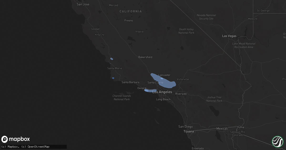
Hail Map on February 7, 2024
Get this storm
February 7 map
$229
one time, instant access
Download today. No call, no setup
Keep the $229
Bought the map and want the full workflow? Apply the entire $229 to a subscription within 7 days. None of it is wasted.
Every map, not just this one
This buys you this map. Subscription and you get every map we run, in the markets you choose from a few cities to whole states to nationwide. Plus real-time alerts the moment a storm fires.
Contact data
Name, contact info, occupancy, even credit band for addresses in the footprint. You go from where it hit to who to call.
Become the source they trust
Unlimited branding weather history reports on demand. You already have the documented answer ready for the property owner, and you are the one who showed up with it.
Property data and RoofTrace estimates
Pull up any address you have got, its value and the exact code rules for that jurisdiction, straight from One Click Code. Then RoofTrace estimates the squares, pitch, and roof value, priced the way you price.
States Impacted by Hail Map on February 7, 2024
Storm reports
Kansas
| Date | Description |
|---|---|
| 02/07/20243:00 PM CST | A local report indicates 58 MPH wind near 2 NNE Goodland |
California
| Date | Description |
|---|---|
| 02/07/20245:57 PM CST | Corrects previous tstm wnd dmg report from 1 s pismo beach. Narrow path of wind damage in grover beach with convective band. |
| 02/07/20245:50 PM CST | Corrects previous non-tstm wnd dmg report from 3 w san luis obispo. Six power poles downed on los osos valey rd near foothill blvd due to convective line. |
| 02/06/202410:30 PM CST | Mesonet station se250 yucca circle |
| 02/06/202410:20 PM CST | Mesonet station 546se mesa vincent 2 with convective line. |
| 02/06/202410:15 PM CST | Mesonet station oosc1 sandstone peak alert with convective line. |
| 02/06/202410:00 PM CST | Tree down on stockton rd near balcom canyon rd. |
| 02/06/20249:56 PM CST | Mesonet station dw2363 saddle peak with convective line. |
| 02/06/20249:30 PM CST | Mesonet station se678 magic mtn truck trl |
| 02/06/20249:27 PM CST | Large tree branch blocking lanes of southbound 405 near 710 connector. |
| 02/06/20249:21 PM CST | Tree down on 100 block of arnaz st with convective line. |
| 02/06/20249:20 PM CST | Mesonet station 555se n3 highway |
| 02/06/20249:20 PM CST | Mesonet station se678 magic mtn truck trl |
| 02/06/20249:00 PM CST | Mesonet station se063 sierra pelona |
| 02/06/20249:00 PM CST | Mesonet station se444 sierra pelona west |
| 02/06/20248:59 PM CST | Mesonet station gmtc1 grass mountain raws with inflow ahead of convective line. |
| 02/06/20248:53 PM CST | Mesonet station mlcc1 mill creek raws with inflow ahead of convective line. |
| 02/06/20248:20 PM CST | Mesonet station se329 juniper mesa rd |
| 02/06/20247:58 PM CST | Multiple trees down on dos pueblos canyon rd near el camino real with convective line. |
| 02/06/20247:40 PM CST | Mesonet station 756se sce rough road with inflow ahead of convective line. |
| 02/06/20247:00 PM CST | Mesonet station pg852 de la concepcion. |
| 02/06/20246:16 PM CST | Power lines down on 4300 block of old santa fe rd due to convective line. |
| 02/06/20246:08 PM CST | Power pole down on huasna rd near lopez dr with convective line. |
| 02/06/20246:05 PM CST | Multiple power lines down at tally ho rd and canyon way in arroyo grande. |
| 02/06/20246:05 PM CST | Corrects previous non-tstm wnd dmg report from arroyo grande. Two large trees down on highway 101 near brisco rd due to convective line. |
| 02/06/20246:00 PM CST | Trees down and facade damage to building near 14th st and grand ave in grover beach. |
| 02/06/20246:00 PM CST | Multiple trees and power lines down in grover beach near rockaway and 9th st in grover beach. Several vehicles damaged. |
| 02/06/20246:00 PM CST | Mesonet station pg715 mt. Lowe |
Cities Impacted by Hail Map on February 7, 2024
- Woodland Hills, CA
- Agoura Hills, CA
- Beverly Hills, CA
- Los Angeles, CA
- Encino, CA
- Tarzana, CA
- Topanga, CA
- Newbury Park, CA
- Calabasas, CA
- Malibu, CA
- Pacific Palisades, CA
- Sherman Oaks, CA
- Westlake Village, CA
- Camarillo, CA
- Lake Hughes, CA
- Littlerock, CA
- Canyon Country, CA
- Castaic, CA
- Sylmar, CA
- Tujunga, CA
- Valyermo, CA
- La Canada Flintridge, CA
- Santa Clarita, CA
- Pearblossom, CA
- Acton, CA
- Azusa, CA
- Palmdale, CA
- Lebec, CA
- Lancaster, CA
- Llano, CA
- Wrightwood, CA
- Pinon Hills, CA
- Lompoc, CA
- San Luis Obispo, CA
- Santa Margarita, CA
- Grover Beach, CA
- Arroyo Grande, CA