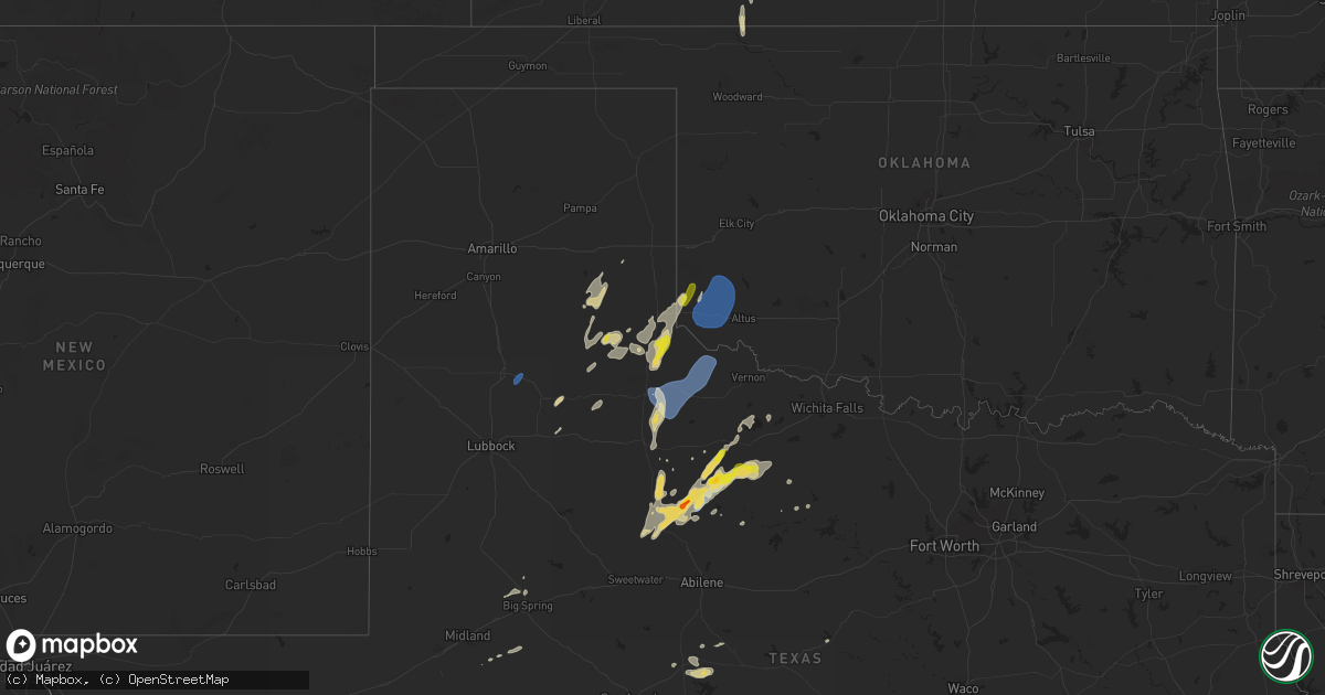
Hail Map on February 2, 2024
Get this storm
February 2 map
$229
one time, instant access
Download today. No call, no setup
Keep the $229
Bought the map and want the full workflow? Apply the entire $229 to a subscription within 7 days. None of it is wasted.
Every map, not just this one
This buys you this map. Subscription and you get every map we run, in the markets you choose from a few cities to whole states to nationwide. Plus real-time alerts the moment a storm fires.
Contact data
Name, contact info, occupancy, even credit band for addresses in the footprint. You go from where it hit to who to call.
Become the source they trust
Unlimited branding weather history reports on demand. You already have the documented answer ready for the property owner, and you are the one who showed up with it.
Property data and RoofTrace estimates
Pull up any address you have got, its value and the exact code rules for that jurisdiction, straight from One Click Code. Then RoofTrace estimates the squares, pitch, and roof value, priced the way you price.
Storm reports
Texas
| Date | Description |
|---|---|
| 02/02/20245:56 PM CST | West texas mesonet. Additional gust to 63 mph measured at 5:57 pm. |
| 02/02/20245:31 PM CST | A tornado was reported approximately 5 miles east of sagerton. |
| 02/02/20245:27 PM CST | Social media video shows hail near or just above quarter size between turkey and estelline. Time and location estimated from radar. |
| 02/02/20245:13 PM CST | Video showed a tornado with the location approximately 1 mile south-southeast of sagerton. |
| 02/02/20244:21 PM CST | A local report indicates 59 MPH wind near 3 WSW Aiken |
| 02/02/20242:48 PM CST | A local report indicates 60 MPH wind near Gardendale |
| 02/02/20242:08 AM CST | Wind gust occurred at juan seguin park. |
| 02/02/202412:20 AM CST | Wind gust occurred on meteor drive. |
| 02/01/202411:40 PM CST | Trees and power lines down in and around the columbus area. |
| 02/01/202411:09 PM CST | Damage to buildings and signs... And several trees uprooted at the city park/golf course. |
| 02/01/20248:29 PM CST | Kcot asos recorded a gust to 56 knots. |
| 02/01/20248:25 PM CST | Ham reports estimated 60 mph wind gust. |
| 02/01/20248:06 PM CST | Large tree limb down over north main street. |
| 02/01/20248:00 PM CST | Quarter size hail reported west of olney. |
| 02/01/20247:46 PM CST | Social media report of a tree down which is blocking a street in bandera. Time estimated via radar. |
| 02/01/20246:22 PM CST | Media relayed report of hail up to half dollar size south of childress. |
| 02/01/20246:21 PM CST | Media relayed report of quarter size hail south of childress. |
| 02/01/20246:16 PM CST | Quarter size hail observed falling in childress on live-streaming webcam. |
| 02/01/20246:15 PM CST | Public video showing hailstones falling... Some of which appear larger than quarters... At fort clark springs in brackettville... Tx. Video was relayed by broadcast med |
| 02/01/20246:13 PM CST | A local report indicates 59 MPH wind near Comanche Springs |
| 02/01/20246:08 PM CST | A local report indicates 61 MPH wind near 1 NW Haskell |
Oklahoma
| Date | Description |
|---|---|
| 02/01/20247:35 PM CST | A local report indicates 58 MPH wind near 5 SE Mangum |
| 02/01/20246:56 PM CST | Also strong winds of 45 to 50 mph. Most of the hail is smaller than quarters. |
Cities Impacted by Hail Map on February 2, 2024
- Garden City, TX
- Knott, TX
- Plainview, TX
- Lockney, TX
- Rule, TX
- Brackettville, TX
- Munday, TX
- Goree, TX
- Childress, TX
- Paducah, TX
- Crowell, TX
- Stamford, TX
- Haskell, TX
- Weinert, TX
- Quanah, TX
- Throckmorton, TX
- Seymour, TX
- Hollis, OK
- Gould, OK
- Vinson, OK
- Eagle Pass, TX
- Asherton, TX
- Eldorado, OK
- Olustee, OK
- Duke, OK
- Mangum, OK
- Altus, OK
- Blair, OK
- Willow, OK
- Granite, OK
- Big Wells, TX
- Cotulla, TX
- Dilley, TX
- Carrizo Springs, TX
- Freedom, OK
- Coldwater, KS
- Talpa, TX
- Ballinger, TX
- Old Glory, TX
- Aspermont, TX
- Crosbyton, TX
- Lelia Lake, TX
- Hedley, TX
- Matador, TX
- McCaulley, TX
- Rotan, TX
- Hamlin, TX
- Turkey, TX
- Lakeview, TX
- Floydada, TX
- O'Brien, TX
- Big Spring, TX
- Knox City, TX
- Del Rio, TX
- Ozona, TX
- Voss, TX
- Wilmore, KS
- Tell, TX
- Clarendon, TX
- Haviland, KS
- Roaring Springs, TX
- Dodson, TX
- Roby, TX
- Rochester, TX
- Falls City, TX
- Floresville, TX
- Poth, TX
- Stockdale, TX
- Spring Branch, TX
- Bulverde, TX
- Boerne, TX
- Bergheim, TX
- Pipe Creek, TX
- Comfort, TX
- Center Point, TX
- Helotes, TX
- Laredo, TX
- Bandera, TX
- Kerrville, TX
- Medina, TX
- Hondo, TX
- D Hanis, TX
- Tarpley, TX
- Sealy, TX
- Eagle Lake, TX
- East Bernard, TX
- Wallis, TX
- Rosenberg, TX
- Brookshire, TX
- Fulshear, TX
- Sabinal, TX
- Batesville, TX
- Newcastle, TX
- Coleman, TX
- Graham, TX
- Fowlerton, TX
- Catarina, TX
- Joshua, TX
- Burleson, TX
- Tilden, TX
- Lipan, TX
- Comanche, TX
- Three Rivers, TX
- George West, TX
- Beeville, TX
- Skidmore, TX
- Crystal City, TX
- Charlotte, TX
- Poteet, TX
- Brownsville, TX
- Los Fresnos, TX
- Woodsboro, TX
- Sinton, TX
- Calliham, TX