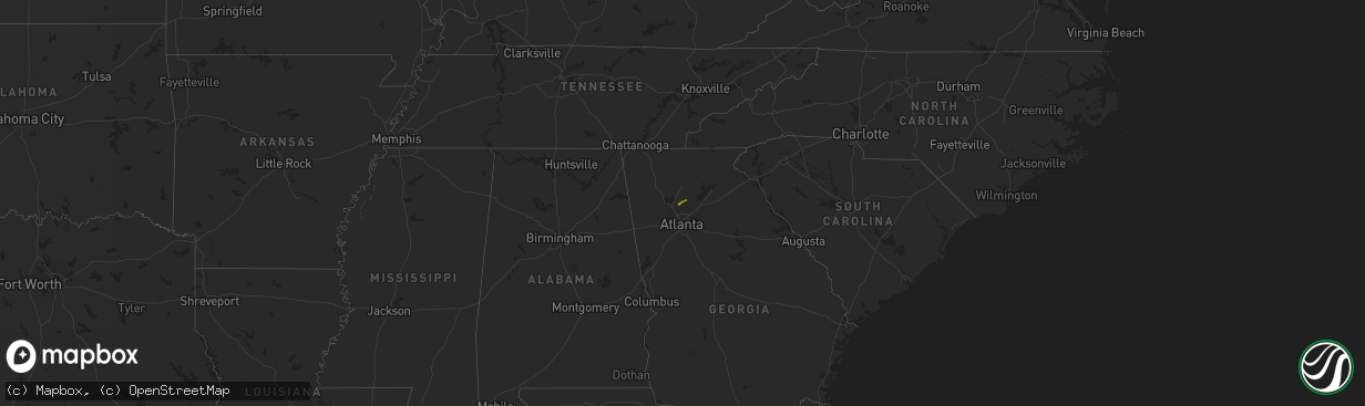
Hail Map on January 30, 2013
The weather event on January 30, 2013 includes Hail map. 1 state and 4 cities were impacted and suffered possible damage. The total estimated number of properties impacted is 3,304.
Want more than just the map?
Turn this storm into a full workflow.
- Owner + property data so you know who to knock
- OnDemand branded weather history reports to win the "did we even have hail?" argument
- RoofTrace estimate so reps stop guessing numbers at the door
Bought this map? Upgrade within 7 days and we'll credit the $230. (10-15 min setup call)
Hail
3,304
Estimated number of impacted properties by a 1.00" hail or larger0
Estimated number of impacted properties by a 1.75" hail or larger0
Estimated number of impacted properties by a 2.50" hail or largerStates Impacted by Hail Map on January 30, 2013
Storm reports
Florida
| Date | Description |
|---|---|
| 01/30/20135:40 PM CST | Tree down on rosemont st. |
| 01/30/20135:33 PM CST | Limbs down on power lines around the county. |
| 01/30/20134:23 PM CST | A large tree went down across a road just n of greenwood. |
| 01/30/20134:18 PM CST | 57 knot peak gust at tyndall air force base. |
| 01/30/20133:55 PM CST | Power lines down near downtown panama city. Some traffic lights out in the city as well. |
| 01/30/20133:54 PM CST | Delayed report from media of tree down on house with structural damage from earlier storms on beach dr and fairy ave. |
| 01/30/20133:50 PM CST | Power lines down in the vicinity of north bonita and east 26th. |
| 01/30/20133:45 PM CST | Multiple trees and powerlines down. |
| 01/30/20133:45 PM CST | Multiple trees and powerlines down. |
| 01/30/20133:30 PM CST | Metal roofing and/or awning blown off of a gas station near bonifay. Submitted via a twitter picture. Time estimated. |
| 01/30/20133:08 PM CST | Trees down across walton county. |
| 01/29/20138:05 PM CST | Trees were blown down along trails in the suwannee river state park. |
| 01/29/20136:47 PM CST | Report of a tree down in or near the road on interstate 10 near mile marker 232. Power also out in this area of jefferson county east of monticello. |
| 01/29/20136:43 PM CST | Tree down blocking eastbound u.s. Highway 98 about 10 miles east of sr267. Fhp report tweeted by broadcast media. |
| 01/29/20136:12 PM CST | Media reports tallahassee fd responding to large tree down on kimbrel rd in woodville area. |
| 01/29/20136:00 PM CST | City of tallahassee reported via twitter that a tree blew down on a power line causing a power outage in the mabry area. |
South Carolina
| Date | Description |
|---|---|
| 01/30/20135:52 PM CST | Several trees down on foster rd |
| 01/30/20134:45 PM CST | Trees down off broadway school rd ene of anderson and just west of belton. |
| 01/30/20134:38 PM CST | Power lines down near intersection of highway 9 and brennan rd. |
| 01/30/20134:17 PM CST | Multiple trees down on chinquapin road. |
| 01/30/20133:11 PM CST | Oak tree with a 12 inch diameter fell onto a fence in seneca. |
| 01/30/20132:50 PM CST | Trees and other limbs down around walhalla. Time given by fireman was around 4 pm. More specific time estimated by radar. |
| 01/29/201310:45 PM CST | Trees down on gilchrist road. |
| 01/29/201310:10 PM CST | Reported tree down on firetower road. |
| 01/29/201310:07 PM CST | One tree down along the intersection of maybank highway bears bluff road. Time estimated by radar. |
| 01/29/20139:45 PM CST | Dot reported a couple of trees down in the foreston area near the county line. |
| 01/29/20139:15 PM CST | Trees down on power lines |
| 01/29/20139:12 PM CST | Dot reported several trees down along rembert church road. |
| 01/29/20139:10 PM CST | Tree down along interstate 95...near mile marker 54. |
| 01/29/20139:10 PM CST | Trees were reported down on ashland road. |
| 01/29/20139:10 PM CST | Trees down on ashland-stokes bridge highway near darlington and lee county line. |
| 01/29/20138:47 PM CST | Tree down near the pineland post office. Time estimated by radar. |
| 01/29/20138:44 PM CST | Dot reported several trees down in the pageland area. |
| 01/29/20138:44 PM CST | Trees down on power lines |
| 01/29/20138:39 PM CST | A few trees down |
| 01/29/20138:26 PM CST | A few trees down |
| 01/29/20138:26 PM CST | A few trees down |
| 01/29/20138:18 PM CST | Trees down on power lines |
| 01/29/20138:12 PM CST | A few trees down in columbia |
| 01/29/20138:00 PM CST | A few trees down |
| 01/29/20137:50 PM CST | A few trees down along college street in irmo |
| 01/29/20137:48 PM CST | Several rees down along us 521 in panhandle of lancaster county |
| 01/29/20137:48 PM CST | Trees down on power lines |
| 01/29/20137:43 PM CST | Trees down on power lines |
| 01/29/20137:43 PM CST | Dot reported several trees down on hwy sc 215 in western fairfield county. |
| 01/29/20137:40 PM CST | Trees down in beech island area |
| 01/29/20137:20 PM CST | Trees down on roads in saluda in ridge spring area |
| 01/29/20137:15 PM CST | Trees down |
| 01/29/20137:15 PM CST | Trees down on power lines |
| 01/29/20137:12 PM CST | A few trees down in columbia |
| 01/29/20137:05 PM CST | Widespread trees down with power outages |
| 01/29/20137:02 PM CST | House windows blown out by wind gusts just east of rock hill. |
| 01/29/20136:55 PM CST | Several trees down along highway 121 in oldtown area |
| 01/29/20136:50 PM CST | Widespread trees down and power outages |
| 01/29/20136:50 PM CST | Trees down county wide with power outages in newberry |
| 01/29/20136:50 PM CST | 2 trees down in the bethel area. There are 2 more trees reported down one each in different parts of york county. |
| 01/29/20136:48 PM CST | 2 trees down around carlisle. Other trees and limbs fell in union county during the day due to gradient wind. |
| 01/29/20136:35 PM CST | 2 trees down in or near sharon. |
| 01/29/20136:30 PM CST | Widespread trees down and power outages |
North Carolina
| Date | Description |
|---|---|
| 01/30/20135:46 PM CST | Trees down. |
| 01/30/20135:40 PM CST | A few trees down across the county. |
| 01/30/20134:40 PM CST | Trees down in green creek area. |
| 01/30/20134:30 PM CST | Trees down. |
| 01/30/20134:30 PM CST | Multiple roads closed across jackson county because of downed trees. |
| 01/30/20134:30 PM CST | Tree fell through a mobile home in graham county. Nobody hurt. |
| 01/30/20134:30 PM CST | Multiple trees down on highway 64 westbound. |
| 01/30/20131:50 PM CST | Scattered small trees and large limbs had to be removed from mainly secondary roads in yancey county. The contact for dot could not be more specific on location. |
| 01/30/20131:25 PM CST | Numerous trees and powerlines down across the county during the past hour. |
| 01/30/201312:42 PM CST | Tree and powerline down on oakfield drive. |
| 01/30/201312:30 PM CST | Trees and powerlines down across western franklin. Ponding of water in low lying areas. |
| 01/30/201312:30 PM CST | Trees and powerlines down on bradley creek road and wood chuck lane. |
| 01/30/201312:00 PM CST | Numerous trees and power lines down around robbinsville |
| 01/30/201312:00 PM CST | Several trees down. |
| 01/30/201311:50 AM CST | Several trees and power lines down. |
| 01/30/201311:35 AM CST | Several trees and power lines down. |
| 01/30/201311:25 AM CST | Several trees and power lines down. |
| 01/30/201311:20 AM CST | Numerous trees down. |
| 01/30/20132:02 AM CST | Jones county 911 reported trees and powerlines down on hwy 41 north just west of trenton. |
| 01/30/20131:53 AM CST | Emergency management reported tree down on hwy 45 near intersection with smithwick road. Time based radar. |
| 01/30/20131:51 AM CST | Department of highways reported a large tree down this morning on alligator loop rd. Report received from pamlico 911 call center. Time estimated by radar. |
| 01/30/20131:48 AM CST | Army corp of engineers pier in duck reported a gust to 59 mph. |
| 01/30/20131:42 AM CST | Tree down on powerlines near liberty park rd and richlands hwy. |
| 01/30/20131:40 AM CST | Wind ripped the roof off of a single wide mobile home. |
| 01/30/20131:35 AM CST | Lenoir county 911 reported powerlines down on british road near jones county border. |
| 01/30/20131:35 AM CST | Craven county emergency management reported two homes with trees on them. |
| 01/30/20131:30 AM CST | A local report indicates 60 MPH wind near WINDSOR |
| 01/30/20131:20 AM CST | Wind ripped the roof off of a single wide mobile home. Time is radar estimated. |
| 01/30/20131:15 AM CST | Lenoir county 911 reported tree down on brothers road in lagrange. |
| 01/30/20131:02 AM CST | Jones county 911 reported trees and powerlines down on hwy 41 north just west of trenton. |
| 01/30/20131:00 AM CST | Martin county em reported a business just off east blvd. With about half of the roof peeled off. Time estimated by radar. |
| 01/30/201312:55 AM CST | Cape fear pilots |
| 01/30/201312:45 AM CST | Tree down on unoccupied vehicle on north 10th street. Fire department enroute. |
| 01/30/201312:40 AM CST | Lenoir county 911 reported powerlines down on british road near jones county border. |
| 01/30/201312:10 AM CST | Tree down across the road hwy 111 and st johns church road |
| 01/30/201312:10 AM CST | Tree down across road |
| 01/29/201311:00 PM CST | Trees down in the vicinity of 813 butler farm road. |
| 01/29/201310:56 PM CST | Trees down 639 south fifth street. |
| 01/29/201310:52 PM CST | Trees down on iona church road near pleasant hope road. |
| 01/29/201310:00 PM CST | Trees down on mcghees mill road. |
| 01/29/20139:50 PM CST | Reports of power-lines down on mt. Harmony church road approximately 1 mile south of us 158 east. |
| 01/29/20139:45 PM CST | Tree down on holeman-ashley road. |
| 01/29/20139:25 PM CST | Roof partially blown off a single story retail shop building. |
| 01/29/20139:18 PM CST | 20 inch diameter tree fell and hit a home. |
| 01/29/20138:55 PM CST | Multiple trees down in troy. Time estimated by radar. |
| 01/29/20138:52 PM CST | Tree down at university drive and huffman mill road |
| 01/29/20138:20 PM CST | Tree blown down along stony gap road. Time estimated. |
| 01/29/20138:18 PM CST | Numerous trees down around the greensboro area...associated with the squall line. |
| 01/29/20138:10 PM CST | Tree blown down along herlocker road. Time estimated. |
| 01/29/20138:10 PM CST | Tree blown down along morgan road. Time estimated. |
| 01/29/20138:00 PM CST | Trees blown down near virginia drive. |
| 01/29/20138:00 PM CST | Trees down near the intersection of skeet club road and johnson street. |
| 01/29/20137:55 PM CST | Tree blown down along talley road. Time estimated. |
| 01/29/20137:55 PM CST | Tree blown down along bear creek church road. Time estimated. |
| 01/29/20137:50 PM CST | Trees down on dahl street |
| 01/29/20137:45 PM CST | Tree down on porter lane. |
| 01/29/20137:20 PM CST | 4 trees reported down off junction rd just north of cooleemee. |
| 01/29/20137:20 PM CST | Tree down at 6910 fisher road. Time estimated by radar. |
| 01/29/20137:07 PM CST | Trees and power lines down along with scattered power outages. |
| 01/29/20136:52 PM CST | Trees and power lines down. |
Mississippi
| Date | Description |
|---|---|
| 01/30/20137:20 AM CST | Reports of trees down scattered through the southern portions of the county. |
| 01/30/20137:00 AM CST | Scattered trees down in the county. |
Virginia
| Date | Description |
|---|---|
| 01/30/20135:29 PM CST | Tree knocked down onto powerlines along brush lane |
| 01/30/20135:27 PM CST | Tree down across rockfish river rd |
| 01/30/20135:26 PM CST | Several trees down across preddy creek rd |
| 01/30/20135:18 PM CST | Trees down blocking us hwy 29 near intersection of us hwy 250 nw of charlottesville |
| 01/30/20135:12 PM CST | Trees down 3200 block of browns gap turnpike |
| 01/30/20135:09 PM CST | Tree knocked down onto powerlines along brush lane |
| 01/30/20134:55 PM CST | Trees down off buffalo springs |
| 01/30/20134:05 PM CST | A local report indicates 62 MPH wind near 2 WNW STEWARTSVILLE |
| 01/30/20133:03 PM CST | 5 inch diameter tree limbs down on virginia tech golf course near prices fork road. |
| 01/30/20132:54 PM CST | Damage to wall of commercial building |
| 01/30/20132:41 PM CST | 15 by 30 foot section of roof blown off house |
| 01/30/20132:41 PM CST | Several trees down in dublin |
| 01/30/20132:41 PM CST | Detached garage heavily damage |
| 01/30/20132:41 PM CST | Part of roof blown off house |
| 01/30/20132:15 PM CST | Mutiple trees down on rt 58 |
| 01/30/20132:11 PM CST | Structure collapse and several trees down in dublin |
| 01/30/20131:57 AM CST | A local report indicates 66 MPH wind near OCEANA NAS |
| 01/30/20131:51 AM CST | A local report indicates 61 MPH wind near NORFOLK |
| 01/30/20131:43 AM CST | A local report indicates 61 MPH wind near NORFOLK |
| 01/30/20131:35 AM CST | A local report indicates 75 MPH wind near LANGLEY AFB |
| 01/30/20131:35 AM CST | A local report indicates 63 MPH wind near DOMINION TERM ASSOC |
| 01/30/20131:30 AM CST | Trees on an apartment complex in the 5000 block of arlington ave. Three apartments suffered damage and were condemned. |
| 01/30/20131:28 AM CST | A local report indicates 75 MPH wind near LANGLEY AFB |
| 01/30/20131:25 AM CST | Trees down across the city blocking numerous roads. |
| 01/30/20131:22 AM CST | Tree fell through the bedroom of a single wide trailer destroying the structure. The occupants were uninjured however a dog was killed by the falling tree. |
| 01/30/20131:05 AM CST | A local report indicates 60 MPH wind near GWYNN |
| 01/30/201312:29 AM CST | 2 pine trees downed...1 onto a residence in walthall subdivision |
| 01/29/20138:50 PM CST | Tree down on rocksprings rd |
| 01/29/20138:50 PM CST | Tree down on cedar rd |
| 01/29/20138:30 PM CST | Tree down on clearview dr |
| 01/29/20137:27 PM CST | Tree down blocking road near intersection of sanford dr and paul ln |
| 01/29/20137:00 PM CST | Several branches about 3 inches in diameter knocked down |
| 01/29/20136:22 PM CST | Trees down across county |
| 01/29/20136:15 PM CST | Couple of trees down western portion of county. |
| 01/29/20136:10 PM CST | Tree down along greens corner rd |
| 01/29/20136:08 PM CST | A few trees down across jerico mills rd |
Alabama
| Date | Description |
|---|---|
| 01/30/20133:51 PM CST | Multiple reports of trees and power lines down across houston county. One tree fell through a trailer - no specific location given at this time. |
| 01/30/20133:30 PM CST | Additional tree and power line damage with another round of thunderstorms across dale county. |
| 01/30/20133:22 PM CST | Numerous reports of trees down across much of geneva county. |
| 01/30/20132:38 PM CST | Trees down in portions of henry county. Some of the tree damage was likely due to strong winds prior to the thunderstorms arriving...however...some of the tree damage a |
| 01/30/20132:30 PM CST | Trees down along lake drive and willow oaks in eufaula. Wind gust estimated around 50 mph. |
| 01/30/20132:00 PM CST | Trees reported down in and around the clopton area in northeast dale county. |
| 01/30/20131:55 PM CST | Numerous reports of trees down across dale county. |
| 01/30/20131:30 PM CST | Shingles off of the house of the county ema director. |
| 01/30/201311:50 AM CST | Trees down on dudleyville road and horseshoe bend road northeast of dadeville. Estimated winds speed 65 mph. |
| 01/30/201311:48 AM CST | Trees down along county road 30. |
| 01/30/201311:39 AM CST | Trees down in and around the community of friendship. |
| 01/30/201311:35 AM CST | Trees down along county road 33. |
| 01/30/201311:28 AM CST | Trees down on highway 22 just east of wadley. |
| 01/30/201311:10 AM CST | Trees down along highway 9 in barfield. |
| 01/30/201311:07 AM CST | Trees down on main street in jacksons gap. Estimated wind speed 60 mph. |
| 01/30/201310:57 AM CST | Trees down on overlook drive. Estimated wind speed 50 mph. |
| 01/30/201310:55 AM CST | Trees down along county road 29. |
| 01/30/201310:35 AM CST | Elmore county sheriffs dept reoprted power lines down on whitman field road just east of us highway 231 near downtown wetumpka. |
| 01/30/201310:28 AM CST | Clarke county ema reports trees down on walker springs road near heritage lane. |
| 01/30/20139:12 AM CST | Clarke county ema reports trees down on prospect road near hwy 154. |
| 01/30/20139:12 AM CST | Large tree fell on house off of reneau street. Some roof damage. |
| 01/30/20139:10 AM CST | A tree down along bernard couch drive. |
| 01/30/20138:50 AM CST | Power lines down on 13th street and a tree down/power lines down at intersection of hwy 21 and hwy 280 |
| 01/30/20138:06 AM CST | Top of tree was torn off of a tree and blown into the road. |
| 01/30/20137:55 AM CST | A few trees down along pinedale rd. |
| 01/30/20137:53 AM CST | A few trees down |
| 01/30/20137:40 AM CST | One tree down north of cuba on county rd 2 |
| 01/30/20137:35 AM CST | County road department reported a large tree down on cr 391 just off the intersection of highway 35. |
| 01/30/20136:53 AM CST | Trees down on romulus road near sipsy high school. |
| 01/30/20136:21 AM CST | Several trees were blown down in and around millbrook. |
| 01/30/20136:20 AM CST | Semi truck blown into ditch |
| 01/30/20136:18 AM CST | Two trees and couple of power lines down on hwy 31 |
| 01/30/20136:14 AM CST | Several planes damaged and major hangar damage at addison airport. Significant damage to the sardis baptist church. |
| 01/30/20136:14 AM CST | Hanger damage at sardis aiport and damage to a church in sardis |
| 01/30/20136:10 AM CST | Tree down on cr 940. Time estimated based on radar. |
| 01/30/20136:05 AM CST | Mobile home and barn in road on cr 1043 cullman/winston county line. Time estimated based on radar. |
| 01/30/20136:05 AM CST | Trees and power lines down on county road 40 just west of county road 77. |
| 01/30/20136:05 AM CST | The tornado crossed the winston and cullman county line just south of cr 1043 causing minor tree damage and destroying a barn on cr 1038. The tornado strengthened to an |
| 01/30/20136:01 AM CST | A tornado touched down north of addison along cr 41 north of hunter road and tracked ene to the cullman county line. The tornado damaged several planes and destroyed a |
West Virginia
| Date | Description |
|---|---|
| 01/30/201310:36 AM CST | Trees down in mingo... Wv on holly bush |
| 01/30/201310:35 AM CST | Part of metal roof blown off home along bell crouch rd. |
| 01/30/201310:24 AM CST | Trees down relayed by nws charleston wv |
| 01/30/201310:14 AM CST | Trees down |
| 01/30/201310:08 AM CST | Trees down |
| 01/30/20139:48 AM CST | Trees down on des moines ave...point marion rd...bethel rd |
| 01/30/20139:36 AM CST | Trees down relayed by nws charleston wv |
| 01/30/20139:35 AM CST | Trees down |
| 01/30/20139:32 AM CST | Trees down |
| 01/30/20139:01 AM CST | Tree down |
| 01/30/20138:36 AM CST | A local report indicates 62 MPH wind near 2 SSE WINDSOR HEIGHTS |
| 01/30/20138:10 AM CST | Nws spouse reports awning blown off of west teays elem |
| 01/30/20137:54 AM CST | Tree down reported by dept of highways |
| 01/30/20137:48 AM CST | Tree down |
| 01/30/20137:05 AM CST | A couple trees down along depue rd. Timed from radar |
Kentucky
| Date | Description |
|---|---|
| 01/30/20138:15 AM CST | Tree down on hwy 1460. |
| 01/30/20138:03 AM CST | Trees down on highway 522 at totz. |
| 01/30/20137:50 AM CST | Power pole blown down in stanville. |
| 01/30/20137:35 AM CST | Power pole blown down in hueysville. |
| 01/30/20137:34 AM CST | Tree down on highway 74. |
| 01/30/20137:33 AM CST | Trees down on highway 1697. |
| 01/30/20137:30 AM CST | A large limb was blown down. |
| 01/30/20137:30 AM CST | Recorded from knott county mesonet station. |
| 01/30/20137:06 AM CST | Trees down on highway 30 at guage. |
| 01/30/20137:03 AM CST | Trees down on highway 80. |
| 01/30/20137:00 AM CST | Trees down. Wind speed estimated at 70 mph. |
| 01/30/20136:54 AM CST | Trees down at the intersection of highways 1161 and 172. |
| 01/30/20136:51 AM CST | Trees down on highway 315. |
| 01/30/20136:50 AM CST | Trees down on highway 1419. |
| 01/30/20136:45 AM CST | Trees down on hwy 191. |
| 01/30/20136:40 AM CST | Emergency manager reports almost all county roads have been blocked because of downed trees. |
| 01/30/20136:30 AM CST | Trees down on us 60 east. |
| 01/30/20136:30 AM CST | Numerous trees down countywide. |
| 01/30/20136:30 AM CST | Numerous trees down across county. |
| 01/30/20136:24 AM CST | Trees down on highway 801. |
| 01/30/20136:24 AM CST | Trees down countywide. |
| 01/30/20136:24 AM CST | Widespread trees down across county. |
| 01/30/20136:20 AM CST | Tree down along hwy 713. |
| 01/30/20136:18 AM CST | Trees down on hwy 229 and several other roads across the county. |
| 01/30/20136:14 AM CST | Trees down on highway 478 near redbird. |
| 01/30/20136:10 AM CST | A tree fell on hwy 111 and a limb from the tree damaged a school bus. |
| 01/30/20136:08 AM CST | Trees down on winchester road in clay city. |
| 01/30/20136:03 AM CST | Two trees were reported down on ky highway 290. |
| 01/30/20136:02 AM CST | Trees down and blocking walton road. |
| 01/30/20136:00 AM CST | Emergency manager reports almost all county roads have been blocked because of downed trees. |
| 01/30/20136:00 AM CST | Trees down at the intersection of spout spring and twin creek road. |
| 01/30/20136:00 AM CST | Trees down on doug hill road. |
New Jersey
| Date | Description |
|---|---|
| 01/30/20132:41 AM CST | Trees and wires down in hamilton twp. |
| 01/30/20132:37 AM CST | Trees and wires down in lawrence twp... Including along princeton pike. |
Maryland
| Date | Description |
|---|---|
| 01/30/20131:24 AM CST | Tree down near three notch rd and n. Sandgates rd |
| 01/30/20131:22 AM CST | Tree down in crumpton. |
| 01/30/20131:18 AM CST | Tree down in centreville. |
| 01/30/20131:16 AM CST | Tree down near 2960 marshall hall rd |
| 01/30/20131:09 AM CST | Tree down near mechanicsville rd and asher rd |
| 01/30/201312:46 AM CST | Tree down near intersection of penns hill rd and marcus lane |
| 01/30/201312:07 AM CST | Tree down near marshalls corner rd and pomfret rd |
| 01/29/201311:57 PM CST | Tree down near 4400 livingston rd |
| 01/29/201310:54 PM CST | Tree down near 4400 livingston rd |
| 01/29/20136:51 PM CST | Tree down near marshalls corner rd and pomfret rd |
Pennsylvania
| Date | Description |
|---|---|
| 01/30/201310:50 AM CST | Trees down on fence at royer mansion and large limb blocking royer mtn road |
| 01/30/201310:24 AM CST | Measured 69 mph gust...pea sized hail and trees down at chickory summit. |
| 01/30/201310:15 AM CST | Tree down on route 30 |
| 01/30/201310:15 AM CST | Trees down |
| 01/30/20139:56 AM CST | Trees down |
| 01/30/20139:52 AM CST | Numerous trees down |
| 01/30/20139:51 AM CST | Trees down |
| 01/30/20139:46 AM CST | Trees down |
| 01/30/20139:46 AM CST | A local report indicates 67 MPH wind near 1 WSW LAWSON HEIGHTS |
| 01/30/20139:45 AM CST | Trees down |
| 01/30/20139:44 AM CST | Trees down |
| 01/30/20139:38 AM CST | Trees down |
| 01/30/20139:30 AM CST | Multiple trees reported down |
| 01/30/20139:27 AM CST | Trees reported down in south fayette township. |
| 01/30/20139:27 AM CST | Trees down |
| 01/30/20139:23 AM CST | Trees down |
| 01/30/20139:19 AM CST | Trees down |
| 01/30/20139:10 AM CST | Trees down |
| 01/30/20139:10 AM CST | Trees down |
| 01/30/20139:10 AM CST | Multiple trees reported down |
| 01/30/20139:06 AM CST | Trees down |
| 01/30/20139:05 AM CST | Trees down |
| 01/30/20139:04 AM CST | Trees reported down in south fayette township. |
| 01/30/20138:58 AM CST | Trees down |
| 01/30/20138:57 AM CST | Trees down |
| 01/30/20138:45 AM CST | Trees down |
Georgia
| Date | Description |
|---|---|
| 01/30/20135:58 PM CST | Several trees down around the county. |
| 01/30/20135:54 PM CST | Multiple trees down in nw thomas county |
| 01/30/20135:40 PM CST | Several trees down on four different roads in the county. |
| 01/30/20135:18 PM CST | Several trees down around the county |
| 01/30/20135:15 PM CST | Powerline and tree down across highway 97. |
| 01/30/20135:15 PM CST | Scattered trees down around the city. |
| 01/30/20135:10 PM CST | Trees down near long dirt rd area of leesburg. Report via walb-tv facebook page. |
| 01/30/20135:06 PM CST | Highway 91 n had many trees down across the road. |
| 01/30/20134:50 PM CST | Numerous trees and power lines down in the county. |
| 01/30/20134:43 PM CST | A few trees and power lines down around the county. |
| 01/30/20134:30 PM CST | Numerous reports of trees and power lines down across early county. |
| 01/30/20134:24 PM CST | Numerous trees down west of macon. |
| 01/30/20134:12 PM CST | Multiple trees and power lines down in the city of americus. |
| 01/30/20134:05 PM CST | Several small trees were blown down along jackson lake road. |
| 01/30/20133:50 PM CST | Ham radio report of numerous trees blown onto mobile home. |
| 01/30/20133:45 PM CST | A carport was blown over on the north side of warner robins...and it damaged a pickup truck when it fell. Additionally several small trees were blown down across the co |
| 01/30/20133:38 PM CST | Five trees blown down at a spotters residence. |
| 01/30/20133:30 PM CST | The 911 center reported numerous trees and powerlines down near winder. |
| 01/30/20133:20 PM CST | Local newspaper showed a photo of a masonry sign blown over at a dentist office on southeast side of barnesville. |
| 01/30/20133:19 PM CST | A couple of reports of tree blown down near coleman in western randolph county. |
| 01/30/20133:15 PM CST | Local newspaper reports numerous trees down along jeff davis road. |
| 01/30/20133:15 PM CST | Local newspaper reports numerous trees down along jeff davis road. |
| 01/30/20133:10 PM CST | Several trees were blown down across the southern portion of the county. |
| 01/30/20133:00 PM CST | Multiple reports of trees blowing down in clay county. A few of the reports were related to non-thunderstorm winds just ahead of the storms...but some of the reports we |
| 01/30/20132:45 PM CST | Trees down on us route 27. |
| 01/30/20132:45 PM CST | Several trees were blown down across the county between 345-400 pm...especially along highway 96 both east and west of butler. |
| 01/30/20132:40 PM CST | Trees and powerlines were reported down near covington by local newspaper. |
| 01/30/20132:37 PM CST | Several trees down in quitman county. |
| 01/30/20132:35 PM CST | Trees were reported down along highway 26 and 520 by local law enforcement. |
| 01/30/20132:30 PM CST | The 911 center reported numerous trees and powerlines down near winder. |
| 01/30/20132:30 PM CST | Around a dozen total trees and powerlines reported down by 911 center. |
| 01/30/20132:15 PM CST | Numerous trees down across the entire county. |
| 01/30/20132:13 PM CST | Multiple trees have come down down across the county. |
| 01/30/20132:00 PM CST | Local newspaper reports numerous trees down in the sharon road area. |
| 01/30/20131:45 PM CST | Several trees were blown down. |
| 01/30/20131:30 PM CST | Several trees were blown down in the eastern portion of the county. |
| 01/30/20131:30 PM CST | A tree was blown down on a house. |
| 01/30/20131:20 PM CST | Several trees were down across the county from the storm that moved through as reported by emergency management. Time estimated from the radar. |
| 01/30/20131:10 PM CST | Multiple trees were blown down across the north and northwest portion of the county |
| 01/30/20131:00 PM CST | Trees down across the county...especially on the east side. |
| 01/30/20131:00 PM CST | Local news outlet out of lagrange reported trees and powerlines down across the area. |
| 01/30/201312:35 PM CST | The 911 center reported up to 9 trees down. |
| 01/30/201312:05 PM CST | *** 1 inj *** a tornado touched down in the sugar creek area and moved northeast before lifting in the hothouse valley area. The ef1 tornado with max wind speeds up to |
| 01/30/201312:00 PM CST | Multiple trees down. |
| 01/30/201312:00 PM CST | Multiple trees down in and around franklin. Streets impacted by downed trees are charlie b johnston and lane road. |
| 01/30/201311:51 AM CST | Multiple trees and powerlines down in dallas on west memorial drive. |
| 01/30/201311:51 AM CST | Multiple trees and powerlines down in dallas on west memorial drive |
| 01/30/201311:50 AM CST | Numerous trees down near burris and sardis roads. |
| 01/30/201311:41 AM CST | Numerous trees down near burris and sardis roads. |
| 01/30/201311:08 AM CST | *** 1 inj *** a tornado touched down in the sugar creek area and moved northeast before lifting in the hothouse valley area. The ef1 tornado with max wind speeds up to |
| 01/30/201311:05 AM CST | An ef1 tornado touched down off of chapman drive and snapped or uprooted hundreds of softwood and hardwood trees as it moved northeast. Eight power poles were snapped i |
| 01/30/201311:00 AM CST | Numerous trees and powerlines down from possible tornado. More reports throughout the western half of the county. |
| 01/30/201311:00 AM CST | Numerous trees and powerlines down. More reports throughout the western half of the county. Two structures were damaged by falling trees. |
| 01/30/201310:30 AM CST | *** 8 inj *** numerous trees and powerlines from redbud rd to hwy 53...several homes damaged...7 poultry homes destroyed and 8 injuries reported in gordon county which |
| 01/30/201310:25 AM CST | Multiple structures damaged along hwy 53 near calhoun. Time estimated from radar. This is a duplicate entry of the ef3 tornado that entered gordon county at 1121 am est |
| 01/30/201310:21 AM CST | *** 8 inj *** this is a continuation of the ef3 tornado that touched down in bartow county. Numerous trees and powerlines from redbud rd to hwy 53...several homes damag |
| 01/30/201310:19 AM CST | Several cars overturned at a mcdonalds restaurant in adairsville. This is a duplicate report of the tornado that touched down at 1112 am est. |
| 01/30/201310:04 AM CST | Tree on house in rome on dogwood street. Person trapped in home but is ok |
| 01/30/201310:01 AM CST | Several trees down on pleasant valley road |
| 01/30/201310:01 AM CST | Tree down on powerlines on woodward street |
| 01/30/201310:01 AM CST | Several trees down on pleasant valley road |
| 01/30/20139:00 AM CST | Trees were blown down in ringgold. |
| 01/30/20138:30 AM CST | Trees were down in stepeh foster state park. Time is based on radar. |
| 01/30/20138:25 AM CST | Tree and powerlines down on ben mosely circle |
| 01/30/20138:10 AM CST | 4 trees were reported down in the county. |
| 01/30/20137:41 AM CST | One tree was reported down due to high winds. |
| 01/30/20137:37 AM CST | There were multiple trees down county wide. |
| 01/30/20137:15 AM CST | Several trees were blown down...many blocking roads...in the northwest portion of the county. |
| 01/30/20137:15 AM CST | A couple of trees were blown down. |
| 01/30/20137:05 AM CST | Several trees were blown down from near the simpson area to east of highway 27 near the heard/carroll county line. |
| 01/30/20137:00 AM CST | A couple of trees were blown down in the frolona area. |
| 01/29/20139:30 PM CST | Trees were blown down along interstate 95. |
| 01/29/20139:30 PM CST | Trees were blown down along highway 110 nw of woodbine. |
| 01/29/20139:25 PM CST | Trees were blown down in tarboro. |
| 01/29/20139:19 PM CST | Local newspaper reports numerous trees down along jeff davis road. |
| 01/29/20138:38 PM CST | Ham radio operator relayed a report from the long county fire deptartment of a tree down on a car. No injuries. Time estimated by radar. |
| 01/29/20138:38 PM CST | Ham radio operator relayed a report from the long county fire department of a tree across the road near family dollar. Time estimated by radar. |
| 01/29/20138:30 PM CST | Trees were down in stephen foster state park. Time is based on radar. |
| 01/29/20138:28 PM CST | Broadcast media relayed a report of trees and power lines down near the griffin lakes area. Time estimated by radar. |
| 01/29/20138:13 PM CST | Three trees were down and also powerlines were reported down in the city. |
| 01/29/20138:06 PM CST | Large trampoline blown from back yard onto highway 280. |
| 01/29/20138:03 PM CST | At least 3 trees down in statesboro. |
| 01/29/20138:00 PM CST | The emergency management had sporadic reports of trees down county wide. The time given was based on radar. |
| 01/29/20137:50 PM CST | Numerous trees and powerlines reported down. |
| 01/29/20137:41 PM CST | Tree down on lake church road. |
| 01/29/20137:39 PM CST | Trees down on power lines with power outages near firestation 11 on hwy 23 |
| 01/29/20137:20 PM CST | A few cable lines down and one tree fell on a vehicle near valdosta. |
| 01/29/20137:11 PM CST | A few reports of trees down in the lakeland area. |
| 01/29/20137:10 PM CST | Several trees were blown down norhtwest of broxton. |
| 01/29/20137:02 PM CST | Several trees down and power lines down |
| 01/29/20137:00 PM CST | Numerous trees and power lines down across the county. |
| 01/29/20137:00 PM CST | Trees were blown down at the intersection of ambrose road and leahs road. The time of damage was based on radar. |
| 01/29/20136:45 PM CST | Tree down on highway 129 n in alapaha. |
| 01/29/20136:34 PM CST | Numerous trees and power lines down across the county. |
| 01/29/20136:30 PM CST | Trees down on scotts ferry road and at the intersection of ridge road and pine ridge road in appling. |
| 01/29/20136:30 PM CST | The emergency manager reported at least a dozen trees were knocked down county wide. A few of those wound up on power lines causing short outages. One tree impacted a p |
| 01/29/20136:30 PM CST | Trees and power lines down on 10 mile rd in fitzgerald. |
| 01/29/20136:20 PM CST | Minor damage to four homes in tift county...not necessarily in the city of tifton. Via georgia ema tweet. |
| 01/29/20136:15 PM CST | Several trees down on nelson st |
| 01/29/20136:15 PM CST | Trees and power lines down around tift county. |
| 01/29/20136:10 PM CST | Tree blown down across highway 32 between i-75 and the irwin-turner county line. Via walb-tv facebook page. |
| 01/29/20136:10 PM CST | 4 houses with major roof damage and several barns knocked down. |
| 01/29/20136:10 PM CST | Minor damage to six homes and one business in colquitt county...not necessarily in the city of moultrie. Via a georgia ema tweet. |
| 01/29/20136:07 PM CST | Numerous trees and power lines down across the county. |
| 01/29/20136:07 PM CST | Numerous trees and power lines down across the county. |
| 01/29/20136:00 PM CST | Trees down along i-20 and intersection with washington rd |
Tennessee
| Date | Description |
|---|---|
| 01/30/20138:25 AM CST | 2 trees down. |
| 01/30/20137:25 AM CST | 2 trees down. |
| 01/30/20137:25 AM CST | 1 tree down. |
| 01/30/20137:15 AM CST | Tree down on long hollow road. |
| 01/30/20136:20 AM CST | Few trees and power lines down. |
| 01/30/20136:12 AM CST | Trees down in mayland in western cumberland county |
| 01/30/20136:10 AM CST | A few trees were downed across the county. |
| 01/30/20136:00 AM CST | A few trees were downed across the county. |
Ohio
| Date | Description |
|---|---|
| 01/30/20137:15 AM CST | A couple trees down along plummer hill rd. Timed from radar. |
| 01/30/20137:05 AM CST | A couple trees down along depue rd. Timed from radar |
| 01/30/20136:50 AM CST | One tree down. Time estimated from radar. |
| 01/30/20136:45 AM CST | One tree down. Time estimated from radar. |