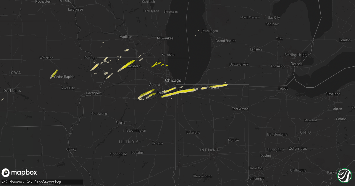
Hail Map on January 28, 2013
Get this storm
January 28 map
$229
one time, instant access
Download today. No call, no setup
Keep the $229
Bought the map and want the full workflow? Apply the entire $229 to a subscription within 7 days. None of it is wasted.
Every map, not just this one
This buys you this map. Subscription and you get every map we run, in the markets you choose from a few cities to whole states to nationwide. Plus real-time alerts the moment a storm fires.
Contact data
Name, contact info, occupancy, even credit band for addresses in the footprint. You go from where it hit to who to call.
Become the source they trust
Unlimited branding weather history reports on demand. You already have the documented answer ready for the property owner, and you are the one who showed up with it.
Property data and RoofTrace estimates
Pull up any address you have got, its value and the exact code rules for that jurisdiction, straight from One Click Code. Then RoofTrace estimates the squares, pitch, and roof value, priced the way you price.
States Impacted by Hail Map on January 28, 2013
Storm reports
Oklahoma
| Date | Description |
|---|---|
| 01/28/20135:56 AM CST | A local report indicates 65 MPH wind near OMEGA |
| 01/28/20135:25 AM CST | A local report indicates 1.50 inch wind near 12 WNW OKARCHE |
| 01/28/20135:20 AM CST | Barn destroyed. 11 power poles downed. |
| 01/28/20135:15 AM CST | Four power poles downed from 2 miles south to 2 miles east of cordell. |
| 01/28/20135:10 AM CST | A local report indicates 1.00 inch wind near CLINTON |
| 01/28/20135:00 AM CST | One barn destroyed. Power poles downed. |
Michigan
| Date | Description |
|---|---|
| 01/28/20131:40 AM CST | A local report indicates 1.00 inch wind near 3 SW WHITE PIGEON |
Indiana
| Date | Description |
|---|---|
| 01/28/20131:15 AM CST | A local report indicates 1.00 inch wind near 2 NW ELKHART |
| 01/27/201311:50 PM CST | Hail lasted 5 minutes and completely covered the ground. Mostly pea size hail but some bigger ones |
| 01/27/201311:25 PM CST | A local report indicates 1.00 inch wind near HIGHLAND |
Illinois
| Date | Description |
|---|---|
| 01/27/201311:11 PM CST | A local report indicates 1.00 inch wind near 1 SSE CHICAGO HEIGHTS |
Iowa
| Date | Description |
|---|---|
| 01/27/20139:33 PM CST | Nickel to quarter sized hail. Time estimated based on radar. |
Cities Impacted by Hail Map on January 28, 2013
- Watonga, OK
- Pawhuska, OK
- Ponca City, OK
- Marland, OK
- Okarche, OK
- Dill City, OK
- Canute, OK
- Foss, OK
- Lanark, IL
- Pearl City, IL
- Monee, IL
- Beecher, IL
- Maquoketa, IA
- Bellevue, IA
- La Motte, IA
- Hennessey, OK
- North Liberty, IN
- Mill Creek, IN
- Rolling Prairie, IN
- South Bend, IN
- New Carlisle, IN
- Geary, OK
- Memphis, TX
- Clinton, WI
- Frankfort, IL
- Morris, IL
- Elkhart, IN
- Granger, IN
- Osceola, IN
- Mishawaka, IN
- White Pigeon, MI
- Bristol, IN
- Shipshewana, IN
- Middlebury, IN
- Kingfisher, OK
- Harvey, IL
- Oak Forest, IL
- Homer Glen, IL
- Posen, IL
- Dolton, IL
- Midlothian, IL
- Blue Island, IL
- Markham, IL
- Mokena, IL
- Chicago, IL
- Orland Park, IL
- Calumet City, IL
- Riverdale, IL
- Tinley Park, IL
- Baileyville, IL
- Freeport, IL
- Shannon, IL
- Forreston, IL
- Winnebago, IL
- Pecatonica, IL
- Rockford, IL
- Ridott, IL
- German Valley, IL
- Olympia Fields, IL
- Matteson, IL
- Dyer, IN
- Westville, IN
- Glenwood, IL
- Chesterton, IN
- Chicago Heights, IL
- Steger, IL
- Munster, IN
- Gary, IN
- University Park, IL
- Portage, IN
- Manhattan, IL
- Hobart, IN
- Michigan City, IN
- Lake Station, IN
- Lansing, IL
- Schererville, IN
- Highland, IN
- Griffith, IN
- Valparaiso, IN
- Park Forest, IL
- Richton Park, IL
- La Porte, IN
- Thomas, OK
- Hydro, OK
- Weatherford, OK
- Bogard, MO
- Seneca, IL
- Plainfield, IL
- Joliet, IL
- Minooka, IL
- Newark, IL
- Shorewood, IL
- Hinton, OK
- Dover, OK
- Calumet, OK
- Oswego, IL
- Yorkville, IL
- Sheridan, IL
- Marseilles, IL
- Keystone, IA
- Blairstown, IA
- Vinton, IA
- Van Horne, IA
- Richmond, MO
- Hardin, MO
- Stockton, IL
- Hitchcock, OK
- Albany, WI
- Evansville, WI
- Brodhead, WI
- Clinton, OK
- Carter, OK
- Sentinel, OK
- Greenfield, OK
- Omega, OK
- Perry, OK
- Arapaho, OK
- Ottawa, IL
- Red Rock, OK
- Savanna, IL
- Caledonia, IL
- Capron, IL
- Poplar Grove, IL
- Lockport, IL
- Wedron, IL
- Wilmington, IL
- Elwood, IL
- Merrillville, IN
- Crete, IL
- Mazon, IL
- Channahon, IL
- New Lenox, IL
- Coal City, IL
- Lockney, TX
- Niotaze, KS
- Peru, KS
- Country Club Hills, IL
- South Holland, IL
- Hammond, IN
- Kaw City, OK
- Serena, IL
- Apple River, IL
- Elizabeth, IL
- Fairfax, OK
- Pawnee, OK
- Burbank, OK
- Ralston, OK
- Mineral Point, WI
- Chadwick, IL
- Fulton, IL
- Thomson, IL
- Mount Carroll, IL
- Bolingbrook, IL
- Scales Mound, IL
- Willow, OK
- Winterset, IA
- Galena, IL
- Hanover, IL
- Marshall, OK
- South Beloit, IL
- Flomot, TX
- Crest Hill, IL
- Robbins, IL
- Belmont, WI
- Fairmont, OK
- Douglas, OK
- Warren, IL
- Lena, IL
- Havana, KS
- Independence, KS
- Preston, IA
- Monroe, WI
- Corn, OK
- Luzerne, IA
- Sabula, IA
- Huntley, IL
- Woodstock, IL
- Crystal Lake, IL
- Bessie, OK
- Orangeville, IL
- Juda, WI
- Kent, IL
- Bronaugh, MO
- Constantine, MI
- Libertyville, IL
- Mundelein, IL
- Grayslake, IL
- Lake Bluff, IL
- Lake Forest, IL
- Ingleside, IL
- Mchenry, IL
- Round Lake, IL
- Rockton, IL
- Roscoe, IL
- Notre Dame, IN
- Shellsburg, IA