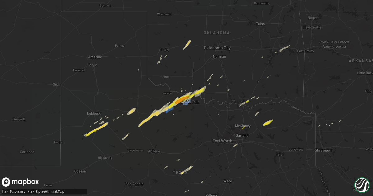
Hail Map on January 24, 2021
Get this storm
January 24 map
$229
one time, instant access
Download today. No call, no setup
Keep the $229
Bought the map and want the full workflow? Apply the entire $229 to a subscription within 7 days. None of it is wasted.
Every map, not just this one
This buys you this map. Subscription and you get every map we run, in the markets you choose from a few cities to whole states to nationwide. Plus real-time alerts the moment a storm fires.
Contact data
Name, contact info, occupancy, even credit band for addresses in the footprint. You go from where it hit to who to call.
Become the source they trust
Unlimited branding weather history reports on demand. You already have the documented answer ready for the property owner, and you are the one who showed up with it.
Property data and RoofTrace estimates
Pull up any address you have got, its value and the exact code rules for that jurisdiction, straight from One Click Code. Then RoofTrace estimates the squares, pitch, and roof value, priced the way you price.
Storm reports
Texas
| Date | Description |
|---|---|
| 01/24/20214:55 AM CST | At 1055 PM CST, a severe thunderstorm was located near New Moore, or 16 miles north of Lamesa, moving northeast at 60 mph. HAZARD...60 mph wind gusts and quarter size hail. SOURCE...Radar indicated. IMPACT...Hail damage to vehicles is expected. Expect wind damage to roofs, siding, and trees. Locations impacted include... Welch and Punkin Center. |
| 01/24/202112:38 AM CST | A local report indicates 1.00 inch wind near 1 NW IOWA PARK |
| 01/24/202112:37 AM CST | A local report indicates 1.00 inch wind near IOWA PARK |
| 01/24/202112:30 AM CST | A local report indicates 1.25 inch wind near 13 NNE SEYMOUR |
| 01/24/202112:02 AM CST | Report of semi blown over... Carport damaged... Barn destroyed... And power polls snapped on 205 on the north side of seymour. Time estimated by radar. |
| 01/24/202112:00 AM CST | A local report indicates 60 MPH wind near 3 NW SEYMOUR |
| 01/23/202110:36 PM CST | At 435 PM CST, a severe thunderstorm was located near Cooper Lake Park South Sulphur, or 15 miles north of Sulphur Springs, moving northeast at 45 mph. HAZARD...Quarter size hail. SOURCE...Radar indicated. IMPACT...Damage to vehicles is possible. Locations impacted include... Deport and Tira. |
Oklahoma
| Date | Description |
|---|---|
| 01/24/20215:15 AM CST | A local report indicates 1.00 inch wind near 3 S DURANT |
Cities Impacted by Hail Map on January 24, 2021
- Hydro, OK
- Geary, OK
- Weatherford, OK
- Corn, OK
- Grandfield, OK
- Electra, TX
- Evant, TX
- Purmela, TX
- Randlett, OK
- Hastings, OK
- Comanche, OK
- Waurika, OK
- Temple, OK
- Wichita Falls, TX
- Checotah, OK
- Eufaula, OK
- Seymour, TX
- Leonard, TX
- Petrolia, TX
- Sheppard Afb, TX
- Byers, TX
- Rochester, TX
- Goree, TX
- Burkburnett, TX
- Old Glory, TX
- Devol, OK
- Knox City, TX
- Aspermont, TX
- Munday, TX
- Iowa Park, TX
- Holliday, TX
- O'Brien, TX
- Stamps, AR
- Porum, OK
- Vian, OK
- Webbers Falls, OK
- Blanket, TX
- Comanche, TX
- Zephyr, TX
- Post, TX
- Odonnell, TX
- Lamesa, TX
- Welch, TX
- Tahoka, TX
- Forestburg, TX
- Muenster, TX
- Rosston, TX
- Dublin, TX
- Lindsay, OK
- Marlow, OK
- Goldthwaite, TX
- Wilson, TX
- Benjamin, TX
- Ratliff City, OK
- Graham, OK
- Sulphur Springs, TX
- Jonesboro, TX
- Elmore City, OK
- Rising Star, TX
- Carbon, TX
- Boswell, OK
- Cumby, TX
- Klondike, TX
- Commerce, TX
- Coleman, TX
- Burkett, TX
- Colbert, OK
- Calera, OK
- Durant, OK
- Dickens, TX
- Desoto, TX
- Dallas, TX
- Willow, OK
- Spur, TX
- Crosbyton, TX
- Duncan, OK
- Snyder, TX
- Paducah, TX
- Dodd City, TX
- Bonham, TX
- Bennington, OK
- Sunset, TX
- San Saba, TX
- Magnolia, AR
- Rotan, TX
- Campbell, TX
- Cooper, TX
- Carter, OK
- Ardmore, OK
- Doddridge, AR
- Fouke, AR
- Atoka, OK
- Lewisville, AR
- Slaton, TX
- Ralls, TX
- Lorenzo, TX
- Pittsburg, OK
- Walters, OK
- Lancaster, TX
- Cedar Hill, TX
- Gatesville, TX
- Dill City, OK
- Sentinel, OK
- Hanna, OK
- Windom, TX
- Cartwright, OK
- Pottsboro, TX
- Denison, TX
- Gustine, TX
- Bokchito, OK
- Allen, TX
- Mckinney, TX