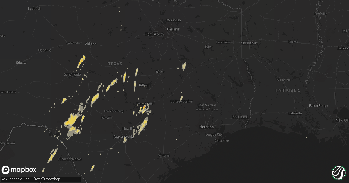
Hail Map on January 24, 2012
Get this storm
January 24 map
$229
one time, instant access
Download today. No call, no setup
Keep the $229
Bought the map and want the full workflow? Apply the entire $229 to a subscription within 7 days. None of it is wasted.
Every map, not just this one
This buys you this map. Subscription and you get every map we run, in the markets you choose from a few cities to whole states to nationwide. Plus real-time alerts the moment a storm fires.
Contact data
Name, contact info, occupancy, even credit band for addresses in the footprint. You go from where it hit to who to call.
Become the source they trust
Unlimited branding weather history reports on demand. You already have the documented answer ready for the property owner, and you are the one who showed up with it.
Property data and RoofTrace estimates
Pull up any address you have got, its value and the exact code rules for that jurisdiction, straight from One Click Code. Then RoofTrace estimates the squares, pitch, and roof value, priced the way you price.
Storm reports
Texas
| Date | Description |
|---|---|
| 01/24/20121:30 PM CST | Near quarter size hail. |
| 01/24/201211:05 AM CST | Golfball size hail near mopac and breaker. |
| 01/24/201211:05 AM CST | Golfball size hail near mopac and braker. |
| 01/24/20124:00 AM CST | Minor roof...barn...and chicken coop damage. Chicken coop was moved 150 yards then destroyed. |
| 01/24/20124:00 AM CST | Several building in devine were damaged... Trees blown over. |
| 01/24/20123:50 AM CST | Retired nws employee reported gusts 50 to 70 mph. |
| 01/24/20123:15 AM CST | Half dollar hail... Over 1.75 inches of rain in 30 mins... And small tree limbs broken in austin. |
| 01/24/20121:10 AM CST | Part of a tin roof was peeled back due to strong straight line winds. Time estimated from radar data. |
| 01/23/201211:39 PM CST | A tornado torn up a few trees on a ranch 10 miles north of rocksprings. |
| 01/23/201211:30 PM CST | Possible tornado west of rocksprings near state road 55. |
Cities Impacted by Hail Map on January 24, 2012
- Rocksprings, TX
- Del Rio, TX
- Mason, TX
- Junction, TX
- London, TX
- Menard, TX
- Hamilton, TX
- San Saba, TX
- Richland Springs, TX
- Teague, TX
- Fairfield, TX
- Norton, TX
- Ballinger, TX
- Miles, TX
- Winters, TX
- Bronte, TX
- San Antonio, TX
- Alvarado, TX
- Lometa, TX
- Goldthwaite, TX
- Garwood, TX
- Brady, TX
- Austin, TX
- Pflugerville, TX
- Round Rock, TX
- Hutto, TX
- Melvin, TX
- Barksdale, TX
- Brackettville, TX
- Streetman, TX
- Purmela, TX
- Sonora, TX
- Leander, TX
- Eden, TX
- Cedar Park, TX
- Breckenridge, TX
- Graham, TX
- Lampasas, TX
- Kempner, TX
- Bryan, TX
- Asherton, TX
- Catarina, TX
- Voca, TX
- Lockhart, TX
- Maxwell, TX
- Kyle, TX
- College Station, TX
- Kingsbury, TX
- Valley Spring, TX
- Martindale, TX
- Dale, TX
- Luling, TX
- Seguin, TX
- Fredonia, TX
- Somerset, TX
- Von Ormy, TX
- Roosevelt, TX
- Dripping Springs, TX
- Uvalde, TX
- Jonesboro, TX
- Evant, TX
- Hearne, TX
- Del Valle, TX
- Eldorado, TX
- Charlotte, TX
- Hext, TX
- Manor, TX
- Pottsville, TX
- McQueeney, TX
- Eola, TX
- Killeen, TX
- Moore, TX
- New Braunfels, TX
- San Marcos, TX
- Buda, TX
- Fort Sill, OK
- Mullin, TX
- Gatesville, TX
- Gustine, TX
- Paint Rock, TX
- Gonzales, TX
- Copperas Cove, TX
- San Angelo, TX
- Mexia, TX
- Liberty Hill, TX
- Elgin, TX
- Driftwood, TX
- Cotulla, TX
- Holliday, TX
- Marion, TX
- La Vernia, TX
- Saint Hedwig, TX