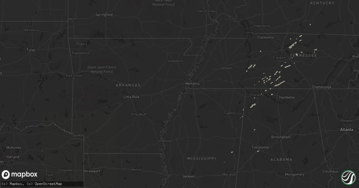
Hail Map on January 13, 2013
Get this storm
January 13 map
$229
one time, instant access
Download today. No call, no setup
Keep the $229
Bought the map and want the full workflow? Apply the entire $229 to a subscription within 7 days. None of it is wasted.
Every map, not just this one
This buys you this map. Subscription and you get every map we run, in the markets you choose from a few cities to whole states to nationwide. Plus real-time alerts the moment a storm fires.
Contact data
Name, contact info, occupancy, even credit band for addresses in the footprint. You go from where it hit to who to call.
Become the source they trust
Unlimited branding weather history reports on demand. You already have the documented answer ready for the property owner, and you are the one who showed up with it.
Property data and RoofTrace estimates
Pull up any address you have got, its value and the exact code rules for that jurisdiction, straight from One Click Code. Then RoofTrace estimates the squares, pitch, and roof value, priced the way you price.
States Impacted by Hail Map on January 13, 2013
Storm reports
Mississippi
| Date | Description |
|---|---|
| 01/13/20134:45 PM CST | A tornado was confirmed by nws survey. The tornado touched down on progress road just east of interstate 59...traveled just over 1 mile. The path width was approximatel |
| 01/12/20136:22 PM CST | Wayne county ema relayed a report of damage to a mobile home and other structures on jordan sumrall road in the denham-progress community near buckatunna. Trees and pow |
| 01/12/20136:15 PM CST | Initial touchdown near odell chambers dr...sporadic tree damage. Tornado to ef-1 intensity...width 200 yards across oscar jordan rd where significant tree damage obsrve |
Louisiana
| Date | Description |
|---|---|
| 01/13/20131:30 PM CST | Roof damage to homes...numerous trees and powerlines down in the vicinity of highway 67 near highway 959. Possible tornado. |
| 01/13/20131:19 PM CST | Damage consistent with ef-0 intensity with winds estimated 65 to 75 mph for approximately 12 miles long and 40 yards wide. Most damage was limited to trees snapped or d |
| 01/13/20131:19 PM CST | Several trees snapped along highway 64 about 2 miles east of highway 964. Recport received at 145 pm. Event time estimated from radar. |
| 01/13/201312:15 PM CST | Confirmed ef1 tornado. Path length less than a mile. Width 25 yards. 1 large barn destroyed. House near barn damaged by debris. 2 mobile homes suffered minor to moderat |
| 01/13/201312:15 PM CST | Emergency manager reported sheet metal torn off of a building. Possible tornado. Event time estimated by radar. |
Tennessee
| Date | Description |
|---|---|
| 01/13/20134:32 PM CST | Possible tornado damage. Abandoned house with roof damage and trees down. 896 floyd rd. 2 m south of eagleville near chapel hill rd. |
| 01/13/20133:36 PM CST | Ef-0 tornado with maximum winds near 85 mph touched down along floyd road just southwest of eagleville. Approximately 100 trees were snapped...and a residence suffered |
| 01/13/20133:27 PM CST | At 896 floyd rd.... Portion of a roof missing and trees down in the area. |
| 01/13/20132:59 PM CST | Trees down along rally hill road and chestnut ridge road in maury county |
Alabama
| Date | Description |
|---|---|
| 01/13/20133:25 PM CST | A few trees and power lines were downed by thunderstorm winds. |
| 01/13/20133:25 PM CST | A few trees and power lines were downed by thunderstorm winds. |
| 01/13/20132:45 PM CST | Large limbs downed on veterans drive in florence. Crews called to remove them from the road. |
| 01/13/20132:45 PM CST | Large limbs downed on veterans drive in florence. Crews called to remove them from the road. |
Cities Impacted by Hail Map on January 13, 2013
- McEwen, TN
- Dickson, TN
- Lawrenceburg, TN
- Leoma, TN
- Decaturville, TN
- Lebanon, TN
- Watertown, TN
- Milton, TN
- Dixon Springs, TN
- Hartsville, TN
- Cookeville, TN
- Bethpage, TN
- Macon, MS
- Gallatin, TN
- Portland, TN
- Tuscaloosa, AL
- Fosters, AL
- Chapel Hill, TN
- College Grove, TN
- Lewisburg, TN
- Columbia, TN
- Linden, TN
- Lobelville, TN
- Centerville, TN
- Prospect, TN
- Petersburg, TN
- Fayetteville, TN
- Frankewing, TN
- Pulaski, TN
- Dellrose, TN
- Ardmore, TN
- Culleoka, TN
- Tremont, MS
- Golden, MS
- Athens, AL
- Rogersville, AL
- Baxter, TN
- Sulphur Springs, TX
- Waynesboro, TN
- Westpoint, TN
- Ethridge, TN
- Rockvale, TN
- Bell Buckle, TN
- Christiana, TN
- Unionville, TN
- Fayette, AL
- Phil Campbell, AL
- Mount Juliet, TN
- Castalian Springs, TN
- Spruce Pine, AL
- Russellville, AL
- Lester, AL
- Anderson, AL
- Lynnville, TN
- Tuscumbia, AL
- Murfreesboro, TN
- Lexington, AL
- Summertown, TN
- Cypress Inn, TN
- Summer Shade, KY
- Eagleville, TN
- Goodspring, TN
- Lafayette, TN
- Westmoreland, TN
- Alexandria, TN
- Killen, AL
- Cornersville, TN
- De Kalb, MS