Hail Map on January 11, 2024
The weather event on January 11, 2024 includes Hail, Wind, and Tornado maps. 4 states and 223 cities were impacted and suffered possible damage. The total estimated number of properties impacted is 106,282.
Want more than just the map?
Turn this storm into a full workflow.
- Owner + property data so you know who to knock
- OnDemand branded weather history reports to win the "did we even have hail?" argument
- RoofTrace estimate so reps stop guessing numbers at the door
Bought this map? Upgrade within 7 days and we'll credit the $230. (10-15 min setup call)
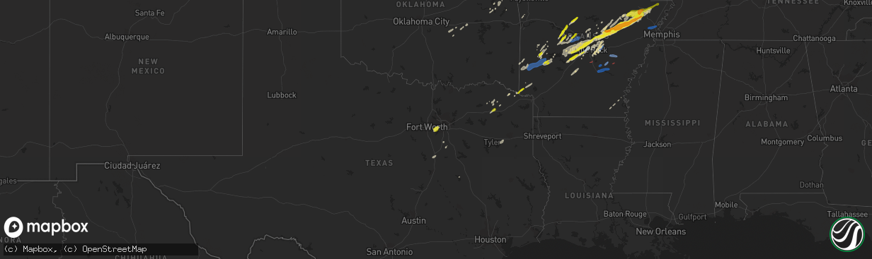
Hail
Wind
Tornado
106,282
Estimated number of impacted properties by a 1.00" hail or larger0
Estimated number of impacted properties by a 1.75" hail or larger0
Estimated number of impacted properties by a 2.50" hail or largerStorm reports
Missouri
| Date | Description |
|---|---|
| 01/11/202412:17 AM CST | A local report indicates 1.00 inch wind near Forsyth |
| 01/10/202411:55 PM CST | Via social media picture. Wind damage to siding and out building. Delayed report. |
| 01/10/202411:50 PM CST | Trees down on highway 39 and timber springs rd. |
| 01/10/202411:30 PM CST | Powerlines down. |
Oklahoma
| Date | Description |
|---|---|
| 01/10/202410:12 PM CST | A local report indicates 1.00 inch wind near Wetumka |
Arkansas
| Date | Description |
|---|---|
| 01/11/20245:37 AM CST | Awos station ksgt stuttgart municipal airport. |
| 01/11/20245:35 AM CST | Powerlines were knocked down. |
| 01/11/20245:16 AM CST | Asos station kpbf pine bluff grider field. |
| 01/11/20245:05 AM CST | Trees were knocked down in this area. |
| 01/11/20244:38 AM CST | Several trees were uprooted. Wind gusts estimated at 80 mph. Time estimated from radar. |
| 01/11/20244:35 AM CST | Trees down across parts of the county. |
| 01/11/20244:27 AM CST | Several roofs were damaged . Wind gusts estimated at 70 mph. Time estimated from radar. |
| 01/11/20244:12 AM CST | Reports of trees down on highway 82 east... Highway 19 south... And highway 78 south. |
| 01/11/20244:00 AM CST | Trees were knocked down across parts of the county. |
| 01/11/20241:59 AM CST | A local report indicates 1.00 inch wind near Oppelo |
| 01/11/20241:42 AM CST | Reports of estimated quarter size hail or larger falling at the e-z mart in foreman. |
| 01/11/202412:40 AM CST | Quarter-sized hail. |
| 01/11/202412:38 AM CST | A local report indicates 1.00 inch wind near Bald Knob |
| 01/11/202412:34 AM CST | Report from mping: 3-inch tree limbs broken; power poles broken. |
| 01/11/202412:28 AM CST | A local report indicates 1.50 inch wind near Searcy |
| 01/11/202412:25 AM CST | Storm spotter estimated thunderstorm wind gusts of 65 mph at markham and santa fe. |
| 01/11/202412:21 AM CST | Report from mping: quarter |
| 01/11/202412:19 AM CST | Mesonet station ard22 us 67 at white river. |
| 01/11/202412:15 AM CST | A local report indicates 1.00 inch wind near 1 NNE Cato |
| 01/11/202412:07 AM CST | Reports of trees and powerlines down. |
| 01/10/202411:53 PM CST | Reports of trees and powerlines down. |
| 01/10/202411:42 PM CST | A local report indicates 1.00 inch wind near Marche |
| 01/10/202411:41 PM CST | Report from mping: half dollar |
| 01/10/202411:39 PM CST | A local report indicates 1.25 inch wind near Maumelle |
| 01/10/202411:39 PM CST | A local report indicates 1.00 inch wind near Elkins |
| 01/10/202411:29 PM CST | A local report indicates 1.00 inch wind near 2 S Pinnacle |
| 01/10/202411:25 PM CST | Location approximated based on report relayed by neighboring nws office; time based on radar; trees snapped and power lines down. |
| 01/10/202411:22 PM CST | Roofs and fences damaged at dixieland rd and broadway. |
| 01/10/202411:00 PM CST | Downed tree/limbs oldham road; relayed by media. |
| 01/10/202411:00 PM CST | Numerous trees down with a few falling on nearby homes. |
| 01/10/202410:52 PM CST | Multiple trees blown down. Tree reported on a house on allan point road. |
| 01/10/202410:34 PM CST | Multiple trees blown down. |
| 01/10/202410:32 PM CST | A local report indicates 60 MPH wind near Perryville |
| 01/10/202410:16 PM CST | Report from mping: quarter |
| 01/10/20248:13 PM CST | A local report indicates 1.00 inch wind near 1 NNE Pottsville |
Louisiana
| Date | Description |
|---|---|
| 01/11/20245:13 AM CST | A few trees down along hwy 15 northwest of farmerville... Louisiana. |
| 01/11/20244:36 AM CST | A tree was downed along hwy 43 between chapman road and albert smith road in far southeast union parish... Louisiana. |
Texas
| Date | Description |
|---|---|
| 01/11/202412:37 AM CST | Multiple reports of quarter size hail around mount vernon. |
Cities Impacted by Hail Map on January 11, 2024
- Dardanelle, AR
- Russellville, AR
- Pottsville, AR
- Searcy, AR
- McRae, AR
- Bradford, AR
- Oil Trough, AR
- Aurora, MO
- Jessieville, AR
- Hot Springs Village, AR
- Romance, AR
- Mount Vernon, AR
- El Paso, AR
- North Little Rock, AR
- Paron, AR
- Little Rock, AR
- Judsonia, AR
- Norman, AR
- Caddo Gap, AR
- Glenwood, AR
- Bonnerdale, AR
- Crane, MO
- Lampe, MO
- Avery, TX
- Pencil Bluff, AR
- Oden, AR
- Story, AR
- Austin, AR
- Cabot, AR
- Muskogee, OK
- Roland, AR
- Maumelle, AR
- Lonsdale, AR
- Benton, AR
- Okemah, OK
- Tahlequah, OK
- Greenbrier, AR
- Danville, AR
- Bogata, TX
- Beebe, AR
- Bentonville, AR
- Jerusalem, AR
- Scotland, AR
- Atkins, AR
- Hulbert, OK
- Malvern, AR
- Hot Springs National Park, AR
- Higginson, AR
- Bryant, AR
- Alexander, AR
- Sherwood, AR
- Jacksonville, AR
- Purdy, MO
- Verona, MO
- Cassville, MO
- Blue Eye, MO
- Mount Ida, AR
- Newport, AR
- Sims, AR
- Talco, TX
- Fort Gibson, OK
- Hector, AR
- Cleveland, AR
- Casa, AR
- Galena, MO
- Cape Fair, MO
- Reeds Spring, MO
- Cedarville, AR
- Rudy, AR
- Van Buren, AR
- Bella Vista, AR
- Pea Ridge, AR
- Clarksville, TX
- Chester, AR
- Mayflower, AR
- Conway, AR
- Umpire, AR
- Grannis, AR
- Wickes, AR
- Mena, AR
- Branson, MO
- Vilonia, AR
- Heber Springs, AR
- Pangburn, AR
- Rose Bud, AR
- Wewoka, OK
- Seminole, OK
- Garner, AR
- Welling, OK
- Perryville, AR
- Bigelow, AR
- Ward, AR
- Lonoke, AR
- Weleetka, OK
- Wetumka, OK
- Waxahachie, TX
- Gravelly, AR
- Bluffton, AR
- Berryville, AR
- Lockesburg, AR
- Alleene, AR
- Ashdown, AR
- Horatio, AR
- Lake City, AR
- Trumann, AR
- Pickton, TX
- Mount Vernon, TX
- Saltillo, TX
- Scott, AR
- Griffithville, AR
- Bald Knob, AR
- Kensett, AR
- Augusta, AR
- Kilgore, TX
- Arlington, TX
- Grand Prairie, TX
- Wilburn, AR
- Cove, AR
- Hatfield, AR
- Kimberling City, MO
- Ola, AR
- Henryetta, OK
- Haworth, OK
- De Kalb, TX
- Hillsboro, TX
- Abbott, TX
- Perry, AR
- Plainview, AR
- Adona, AR
- Jewett, TX
- Morrilton, AR
- Bauxite, AR
- Hollister, MO
- Weiner, AR
- Beedeville, AR
- McCrory, AR
- Fisher, AR
- Hickory Ridge, AR
- Harrisburg, AR
- Leola, AR
- Italy, TX
- Ennis, TX
- Tyler, TX
- Foreman, AR
- Overton, TX
- Dallas, TX
- Seagoville, TX
- Amagon, AR
- Belleville, AR
- Monette, AR
- Black Oak, AR
- Manila, AR
- Jonesboro, AR
- Cash, AR
- Bay, AR
- Dierks, AR
- Langley, AR
- Newhope, AR
- Crawfordsville, AR
- Turrell, AR
- Earle, AR
- Houston, AR
- Altheimer, AR
- Pine Bluff, AR
- Grady, AR
- Humphrey, AR
- Wabbaseka, AR
- Stuttgart, AR
- Ulm, AR
- Sherrill, AR
- Hamburg, AR
- Montrose, AR
- Caraway, AR
- Dermott, AR
- England, AR
- Cherry Valley, AR
- Little Rock Air Force Base, AR
- Watts, OK
- Colcord, OK
- Jay, OK
- Decatur, AR
- Maysville, AR
- Siloam Springs, AR
- Gravette, AR
- Gentry, AR
- Summers, AR
- Fayetteville, AR
- Centerton, AR
- Hiwasse, AR
- Springdale, AR
- Cave Springs, AR
- Rogers, AR
- Lowell, AR
- Garfield, AR
- Seligman, MO
- Washburn, MO
- Eureka Springs, AR
- Eagle Rock, MO
- Shell Knob, MO
- Golden, MO
- Pineville, MO
- Walnut Shade, MO
- Forsyth, MO
- Rockaway Beach, MO
- Spokane, MO
- Chestnutridge, MO
- Ponce De Leon, MO
- Highlandville, MO
- Billings, MO
- Nixa, MO
- Marionville, MO
- Ozark, MO
- Clever, MO
- Chadwick, MO
- Sparta, MO
- Garrison, MO
- Oldfield, MO
- Rogersville, MO
- Fordland, MO
- Seymour, MO
- Bruner, MO
- Ava, MO
- Redfield, AR