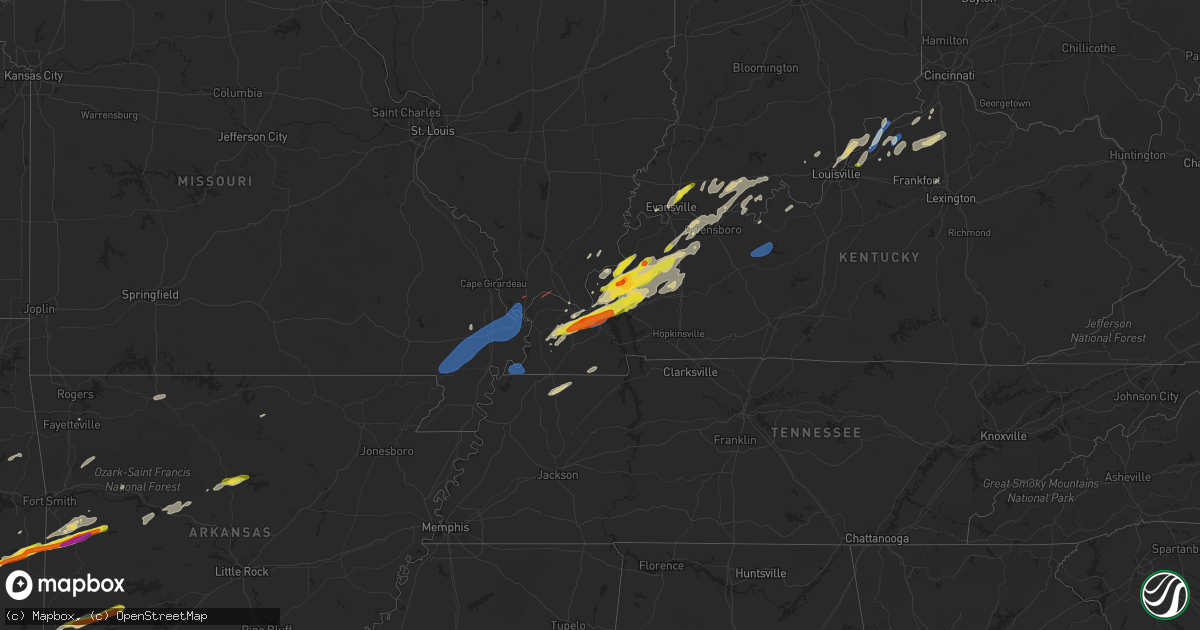
Hail Map on January 11, 2023
Get this storm
January 11 map
$229
one time, instant access
Download today. No call, no setup
Keep the $229
Bought the map and want the full workflow? Apply the entire $229 to a subscription within 7 days. None of it is wasted.
Every map, not just this one
This buys you this map. Subscription and you get every map we run, in the markets you choose from a few cities to whole states to nationwide. Plus real-time alerts the moment a storm fires.
Contact data
Name, contact info, occupancy, even credit band for addresses in the footprint. You go from where it hit to who to call.
Become the source they trust
Unlimited branding weather history reports on demand. You already have the documented answer ready for the property owner, and you are the one who showed up with it.
Property data and RoofTrace estimates
Pull up any address you have got, its value and the exact code rules for that jurisdiction, straight from One Click Code. Then RoofTrace estimates the squares, pitch, and roof value, priced the way you price.
States Impacted by Hail Map on January 11, 2023
Storm reports
Indiana
| Date | Description |
|---|---|
| 01/11/20234:30 AM CST | Timed blended from radar estimate and observer estimate. Also mentioned there could have been larger hail... But they did not measure it directly. |
| 01/11/20233:43 AM CST | Quarter-size hail reported in ireland in northwest dubois county. |
Illinois
| Date | Description |
|---|---|
| 01/11/20232:01 AM CST | Relayed report of a brief tornado touchdown near i-57 at mounds. |
Arkansas
| Date | Description |
|---|---|
| 01/10/202310:00 PM CST | A local report indicates 1.00 inch wind near 1 N CADDO GAP |
| 01/10/20238:58 PM CST | A local report indicates 1.75 inch wind near 1 N ELM PARK |
| 01/10/20238:55 PM CST | A local report indicates 2.00 inch wind near 1 WSW ELM PARK |
Missouri
| Date | Description |
|---|---|
| 01/11/202312:58 AM CST | Time estimated by radar. |
Kentucky
| Date | Description |
|---|---|
| 01/11/20235:47 AM CST | Roof damage to ben johnson elementary school gym. |
| 01/11/20234:35 AM CST | Multiple reports on social media of 1 inch hail. |
| 01/11/20234:19 AM CST | Report from mping: golf ball |
| 01/11/20234:12 AM CST | A local report indicates 1.00 inch wind near 2 W PRINCETON |
| 01/11/20233:47 AM CST | Report from mping: quarter |
| 01/11/20233:35 AM CST | Quarter sized hail between exits 16 and 17 in the reidland area. |
| 01/11/20233:34 AM CST | Golfball hail reported in reidland. |
| 01/11/20233:21 AM CST | Report from mping: quarter |
| 01/11/20232:49 AM CST | Quarter sized hail in clay. |
| 01/11/20232:49 AM CST | A local report indicates 1.00 inch wind near CLAY |
| 01/11/20232:23 AM CST | Photos of golfball sized hail in marion... Ky. Time estimated by radar. |
| 01/11/20232:03 AM CST | Ef-1 tornado with peak winds near 90 mph. Track began in northern ballard co ky and ended in massac county il near hillerman... Il. Path length 6.7 mi and max width abo |
Oklahoma
| Date | Description |
|---|---|
| 01/10/20238:15 PM CST | A local report indicates 1.00 inch wind near 1 N HEAVENER |
| 01/10/20238:15 PM CST | Relay via social media. |
Cities Impacted by Hail Map on January 11, 2023
- Miller City, IL
- Mounds, IL
- Dexter, MO
- Bernie, MO
- Charleston, MO
- Parma, MO
- Sikeston, MO
- Catron, MO
- Cairo, IL
- Matthews, MO
- Malden, MO
- Canalou, MO
- East Prairie, MO
- Campbell, MO
- Anniston, MO
- Essex, MO
- Bertrand, MO
- Hickman, KY
- Calvert City, KY
- Gilbertsville, KY
- Benton, KY
- Elberfeld, IN
- Evansville, IN
- Chandler, IN
- Lynnville, IN
- Tallulah, LA
- Vicksburg, MS
- Madison, IN
- Campbellsburg, KY
- Pendleton, KY
- Bedford, KY
- Vevay, IN
- La Grange, KY
- Carrollton, KY
- Worthville, KY
- Turners Station, KY
- Owenton, KY
- Fordsville, KY
- Olaton, KY
- McDaniels, KY
- Falls Of Rough, KY
- Hardinsburg, KY
- Burna, KY
- Salem, KY
- Marion, KY
- Clay, KY
- Dixon, KY
- Sturgis, KY
- Grand Rivers, KY
- Eddyville, KY
- Fredonia, KY
- Melber, KY
- Paducah, KY
- Hickory, KY
- Symsonia, KY
- Princeton, KY
- Kuttawa, KY
- Boaz, KY
- Cunningham, KY
- Fancy Farm, KY
- Nebo, KY
- Slaughters, KY
- Providence, KY
- Manitou, KY
- Sebree, KY
- Robards, KY
- Heavener, OK
- Mansfield, AR
- Clayton, OK
- Hartford, AR
- Howe, OK
- Wister, OK
- Waldron, AR
- Poteau, OK
- Magazine, AR
- Nashoba, OK
- Talihina, OK
- Booneville, AR
- Dierks, AR
- Umpire, AR
- Langley, AR
- Newhope, AR
- Glenwood, AR
- Caddo Gap, AR
- Norman, AR
- Higden, AR
- Edgemont, AR
- Clinton, AR
- Fairfield Bay, AR
- Shirley, AR
- Hartman, AR
- Clarksville, AR
- Mountainburg, AR
- Elkins, AR
- Winslow, AR
- Boonville, IN
- Tennyson, IN
- Derby, IN
- Tell City, IN
- Leopold, IN
- Clarksville, IN
- Elizabethtown, IL
- Herod, IL
- Palmyra, IN
- New Salisbury, IN
- Shady Point, OK
- Dry Ridge, KY
- Webster, KY
- Brandenburg, KY
- Guston, KY
- Corinth, KY
- Williamstown, KY
- Martin, TN
- Dresden, TN
- Palmersville, TN
- Cloverport, KY
- Pleasureville, KY
- New Castle, KY
- Lockport, KY
- Bethlehem, KY
- Perry Park, KY
- Warsaw, KY
- Verona, KY
- Buckner, KY
- Crestwood, KY
- Alpena, AR
- Harrison, AR
- Smithland, KY
- Gillham, AR
- Eminence, KY
- Georgetown, KY
- Midway, KY
- Bell City, MO
- Greenville, IN
- Pekin, IN
- Borden, IN
- Murray, KY
- Hazel, KY
- Ledbetter, KY
- Bunch, OK
- Stilwell, OK
- Welling, OK
- Delhi, LA
- Madisonville, KY
- Earlington, KY
- Lamar, IN
- Chrisney, IN
- Sanders, KY
- Sparta, KY
- Grannis, AR
- Henderson, KY
- Dardanelle, AR
- Belleville, AR
- Delaware, AR
- Goshen, KY
- Charlestown, IN
- Marysville, IN
- Westport, KY
- Sellersburg, IN
- New Washington, IN
- Bethlehem, IN
- Jeffersonville, IN
- Prospect, KY
- Ferdinand, IN
- Saint Meinrad, IN
- Dale, IN
- Santa Claus, IN
- Huntington, AR
- Greenwood, AR
- Charleston, AR
- Fort Smith, AR
- English, IN
- Branchville, IN
- Saint Croix, IN
- Owensboro, KY
- Grandview, IN
- Richland, IN
- Reed, KY
- Rockport, IN
- Maceo, KY
- Evanston, IN
- Bristow, IN
- Cave In Rock, IL
- Mount Vernon, IN
- Bee Branch, AR
- Smithfield, KY
- Milton, KY
- Pottsville, AR
- Atkins, AR
- Russellville, AR
- Scotland, AR
- Sulphur, KY
- Branch, AR
- Bardwell, KY
- Tiline, KY
- Brockwell, AR
- Pineville, AR
- Calico Rock, AR
- Cannelton, IN
- Hawesville, KY
- Troy, IN
- Vian, OK
- Park Hill, OK
- Gore, OK
- Gentryville, IN
- Fayetteville, AR
- Eupora, MS
- Calhoun, KY
- Dawson Springs, KY
- Mayfield, KY
- Morganfield, KY
- Arlington, KY
- Utica, KY
- Hanson, KY
- Villa Ridge, IL
- Kevil, KY
- Grand Chain, IL
- Louisville, KY
- Pewee Valley, KY