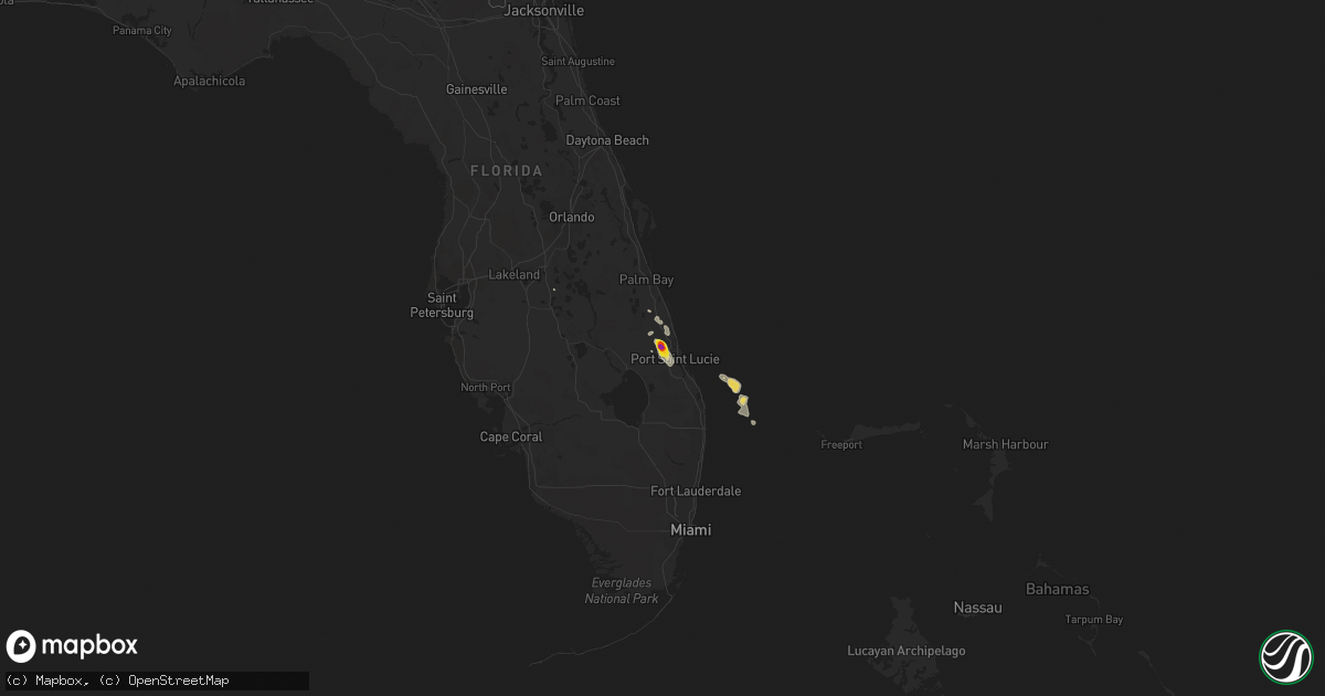
Hail Map on January 10, 2022
Get this storm
January 10 map
$229
one time, instant access
Download today. No call, no setup
Keep the $229
Bought the map and want the full workflow? Apply the entire $229 to a subscription within 7 days. None of it is wasted.
Every map, not just this one
This buys you this map. Subscription and you get every map we run, in the markets you choose from a few cities to whole states to nationwide. Plus real-time alerts the moment a storm fires.
Contact data
Name, contact info, occupancy, even credit band for addresses in the footprint. You go from where it hit to who to call.
Become the source they trust
Unlimited branding weather history reports on demand. You already have the documented answer ready for the property owner, and you are the one who showed up with it.
Property data and RoofTrace estimates
Pull up any address you have got, its value and the exact code rules for that jurisdiction, straight from One Click Code. Then RoofTrace estimates the squares, pitch, and roof value, priced the way you price.
States Impacted by Hail Map on January 10, 2022
Storm reports
Florida
| Date | Description |
|---|---|
| 01/10/20224:55 PM CST | Delayed report. Public reports hail estimated at nickel to quarter size near the pga village in saint lucie west. Time estimated from radar. |
| 01/10/20224:45 PM CST | Delayed report. Several reports received from the public show hail up to 2 inches west of fort pierce... Near the saint lucie fairgrounds... Intersection of state road |
| 01/10/20224:40 PM CST | Quarter to ping pong ball sized hail reported near the saint lucie fairgrounds... Relayed via broadcast media. Time estimated from radar. |
| 01/10/20224:40 PM CST | A local report indicates 1.00 inch wind near 5 NNW CARLTON |
| 01/10/20224:40 PM CST | Golf ball sized hail reported via social media. Time estimated by radar. |
| 01/09/202211:32 PM CST | At 531 PM EST, a severe thunderstorm was located 10 miles west of Treasure Coast Airport, or 11 miles west of White City, moving southeast at 15 mph. HAZARD...60 mph wind gusts and quarter size hail. SOURCE...Radar indicated. IMPACT...Hail damage to vehicles is expected. Expect wind damage to roofs, siding, and trees. Locations impacted include... Port Saint Lucie, Fort Pierce, White City, Port Saint Lucie River Park and Indian River Estates. |
| 01/09/202210:45 PM CST | At 444 PM EST, a severe thunderstorm was located 8 miles northeast of Kissimmee Prairie Preserve, or 12 miles west of Blue Cypress Lake, moving east at 25 mph. HAZARD...60 mph wind gusts and quarter size hail. SOURCE...Radar indicated. IMPACT...Hail damage to vehicles is expected. Expect wind damage to roofs, siding, and trees. Locations impacted include... Fellsmere and Blue Cypress Lake. |
| 01/09/202210:21 PM CST | At 421 PM EST, a severe thunderstorm was located near Lake Wales, moving east at 15 mph. HAZARD...Quarter size hail. SOURCE...Radar indicated. IMPACT...Damage to vehicles is expected. Locations impacted include... Lake Wales, Crooked Lake Park, Hillcrest Heights, Highland Park, Indian Lake Estates, Babson Park and Waverly. |