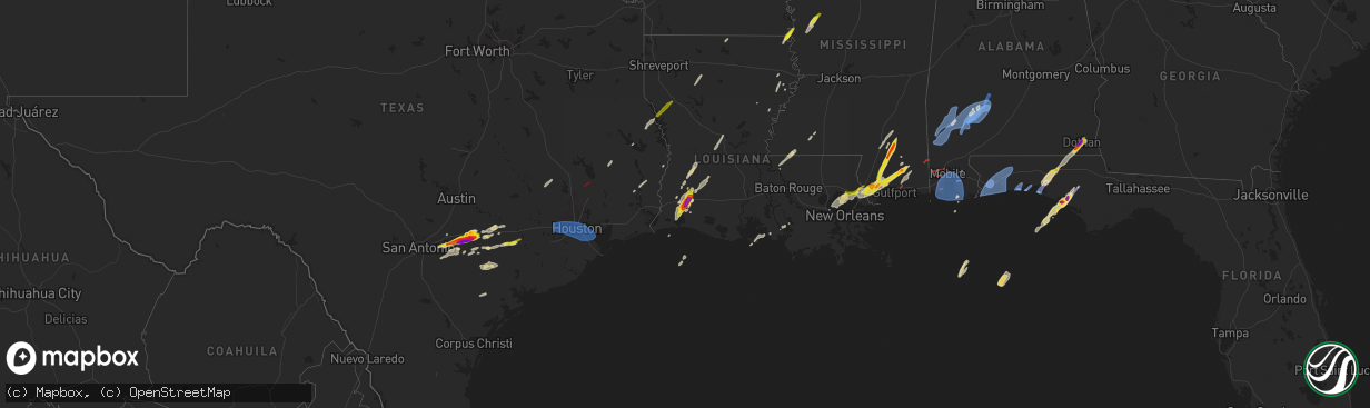
Hail Map on January 8, 2024
The weather event on January 8, 2024 includes Hail, Wind, and Tornado maps. 6 states and 248 cities were impacted and suffered possible damage. The total estimated number of properties impacted is 82,646.
Want more than just the map?
Turn this storm into a full workflow.
- Owner + property data so you know who to knock
- OnDemand branded weather history reports to win the "did we even have hail?" argument
- RoofTrace estimate so reps stop guessing numbers at the door
Bought this map? Upgrade within 7 days and we'll credit the $230. (10-15 min setup call)
Hail
Wind
Tornado
82,646
Estimated number of impacted properties by a 1.00" hail or larger77,206
Estimated number of impacted properties by a 1.75" hail or larger5,383
Estimated number of impacted properties by a 2.50" hail or largerStorm reports
Florida
| Date | Description |
|---|---|
| 01/08/20245:50 AM CST | Structural damage to homes in this area corresponds to a tds from evx radar. |
| 01/08/20245:50 AM CST | Measured by weatherstem station. |
| 01/08/20245:42 AM CST | Measured by kpns. |
| 01/08/20245:39 AM CST | Multiple reports of a tornado from spotters and public crossing us-98 east of hathaway bridge. |
| 01/08/20245:37 AM CST | Report from mping: hen egg |
| 01/08/20245:37 AM CST | Multiple power poles down along highway 87. |
| 01/08/20245:35 AM CST | *** 2 inj *** a tree fell on a home on the 6900 block of w jackson st... Causing a partial roof collapse and injuring 2 people. |
| 01/08/20245:34 AM CST | An ambient station measured a gust of 68.4 mph. |
| 01/08/20245:32 AM CST | 1.25 hail reported at the wjhg-tv panama city beach about 1 mile east of the hathaway bridge. |
| 01/08/20245:30 AM CST | Significant structural damage to beach homes in panama city beach. One home leaning sideways from its foundation. Photo via social media. |
| 01/08/20245:30 AM CST | Spotter reported tornado damage to homes from tornado. |
| 01/08/20245:30 AM CST | Hail at wjhg tv station. |
| 01/08/20245:10 AM CST | Measured by weatherstem station at navarre beach marine science station. |
| 01/08/20245:02 AM CST | Tds on evx radar crossed into far southern holmes county along r m ward road. |
| 01/08/20245:01 AM CST | Report from mping: quarter |
| 01/08/20245:00 AM CST | Spotter report of a tornado crossing i-10 southwest of ponce de leon. |
| 01/08/20244:38 AM CST | Tds appeared from evx radar as the storm moved onshore from choctawhatchee bay. |
| 01/08/20244:33 AM CST | Ambient weather station measured 60 mph wind gust in walton county at santa rosa beach. |
| 01/08/20244:30 AM CST | Tds appeared from evx just before the storm moved into choctawhatchee bay. |
| 01/08/20244:28 AM CST | Measured wind gust of 106 mph at ed walline beach access weatherstem. |
| 01/08/20242:37 AM CST | Measured by kndz. |
| 01/08/20242:24 AM CST | A local report indicates 62 MPH wind near Pensacola International |
Georgia
| Date | Description |
|---|---|
| 01/08/20245:30 AM CST | A tree was downed in the 1900 block of salem road. |
| 01/08/20244:30 AM CST | A tree was downed on highway 166 at tyree rd. |
| 01/08/20244:07 AM CST | One tree down at the intersection of gum creek airport rd and dowdy rd. |
| 01/08/20244:00 AM CST | One tree down at the intersection of welcome rd and roosterville rd. |
Louisiana
| Date | Description |
|---|---|
| 01/08/20245:52 PM CST | Corrects previous flash flood report from pearl river. Public reports quarter-sized hail in pearl river in st tammany parish. |
| 01/08/20245:19 PM CST | A local report indicates 1.00 inch wind near 2 ESE Mandeville |
| 01/08/20243:42 PM CST | Em reported structural damage to a few homes and businesses. |
| 01/08/202412:30 PM CST | Thunderstorm wind damage occurred near hackberry. An rv was flipped over along with outbuilding and powerline damage. |
| 01/08/202412:24 PM CST | Social media picture of quarter size hail. |
| 01/08/202412:10 PM CST | 2 inch hail in downtown lake charles over toward sowela community college. |
| 01/08/202411:57 AM CST | Severe thunderstorm wind gusts ripped a large rv awning from the ground and carried it into some power lines. There was also one home that had minor roof damage. |
| 01/08/202411:52 AM CST | 2 inch hail observed at the lake charles national weather service office. Egg size. |
| 01/08/20242:25 AM CST | Public reports 2 trees blown down. |
| 01/08/20241:19 AM CST | Tree uprooted and fell over on structure causing damage near hwy 36 in abita springs. |
| 01/07/20246:25 PM CST | Two large pine trees down. |
Texas
| Date | Description |
|---|---|
| 01/08/20245:59 PM CST | Marine thunderstorm wind gust occurred at the crab lake weatherflow site |
| 01/08/20245:44 PM CST | Asos reported a 55 knot wind gust at cc-nas. |
| 01/08/20245:20 PM CST | Powerline down. Residents without power until 9am 1/9. |
| 01/08/20244:50 PM CST | Trees and power lines down near the intersection of fresa road and lafferty road. |
| 01/08/20244:47 PM CST | Trees down north of buna. |
| 01/08/20244:38 PM CST | Large tree downed near the intersection of mykawa road and bellfort avenue. |
| 01/08/20244:30 PM CST | Damage to street signs. Street light downed and damaged. |
| 01/08/20244:05 PM CST | Powerlines down in batson. Time based off radar. |
| 01/08/20244:04 PM CST | Severe thunderstorm wind gusts damaged numerous trees and a few power lines on the northern edge of colmesneil. There was also some minor roof damage to a few homes. |
| 01/08/20243:42 PM CST | Hail up to quarter sized observed south of rock island. |
| 01/08/20243:06 PM CST | Downed tree blown into power line at us 77 alt near the railroad crossing. |
| 01/08/20243:04 PM CST | Local reports tree / powerline damage. Minor house damage. Possible tornado damage. Time estimated by radar. |
| 01/08/20242:30 PM CST | Report of a downed and sparking power line near business us 183 north. |
| 01/08/20242:17 PM CST | Spotter reported a tornado on the ground near coldspring... Tx. |
| 01/08/20242:09 PM CST | Golf ball size hail west of gonzales on hwy 90. |
| 01/08/20242:05 PM CST | Hail up to the size of tennis balls dented a car in gonzales. The average hail stones were golf ball size. |
| 01/08/20242:05 PM CST | Traffic light signal down at the intersection of saint joseph and saint lawrence. Txdot on scene. Time estimated via radar. |
| 01/08/20242:00 PM CST | Picture of several hail stones ranging from 2 to 3 inches in diameter via x. Location approximately 6 miles west of gonzalez. Time estimated. |
| 01/08/20242:00 PM CST | Tennis ball size hail near h-4 dam on lake gonzales. |
| 01/08/20241:58 PM CST | Emergency manager sent a picture of 2.25 inch hail in belmont. |
| 01/08/20241:54 PM CST | Report from mping quarter |
| 01/08/202412:32 PM CST | A wooden porch was blown off a home near the intersection of hwy 03 and 1592. A tree was downed along with damage reported to a concession stand and a nearby trampoline |
| 01/07/20247:00 PM CST | Powerline down. |
Alabama
| Date | Description |
|---|---|
| 01/08/20245:54 AM CST | Tds on eox radar at this location. |
| 01/08/20245:53 AM CST | Ping-pong ball-sized hail falling in downtown dothan. Report verified through social media. |
| 01/08/20245:52 AM CST | Report from mping: baseball |
| 01/08/20245:38 AM CST | Mesonet station fw3681 dothan. |
| 01/08/20244:53 AM CST | Power poles snapped at the base and lines down on al-59. |
| 01/08/20244:47 AM CST | Several power poles and lines down in the road on us highway 90. |
| 01/08/20244:26 AM CST | Usa mesonet site in fairhope recorded a 73 mph thunderstorm wind gust. |
| 01/08/20244:09 AM CST | Siding ripped off the side of a hotel in the mcgowan park area. Numerous pictures and videos via social media. |
| 01/08/20244:05 AM CST | Part of a rooftop peeled off an apartment complex. Pictures via social media. |
| 01/08/20244:00 AM CST | Trees down across cody rd. |
| 01/08/20243:57 AM CST | Damage to several wooden and brick fences in the subdivisions lining cottage hill rd. |
| 01/08/20243:50 AM CST | Numerous trees down in the mcintosh community... Predominantly focused on the southern side of town. |
| 01/08/20243:45 AM CST | Multiple trees down in the jackson community. |
| 01/07/20246:50 PM CST | Large tree uprooted and powerlines downed. |
Mississippi
| Date | Description |
|---|---|
| 01/08/20244:09 PM CST | Motorist encountered hail resulting in small dents while driving between avon and glen allan. |
| 01/08/20243:30 PM CST | Emergency management reported golf ball size hail in brooklyn. |
| 01/08/20243:18 AM CST | Asos station kgpt gulfport-biloxi intl airport. |
| 01/08/202412:53 AM CST | Trees and powerlines were downed along tower rd east of moselle. |
| 01/08/202412:53 AM CST | A tree fell on a house along w 8th st. |
| 01/08/202412:48 AM CST | A tree fell on a house and on powerlines along rawls springs rd. |
| 01/08/202412:30 AM CST | Emergency management reported multiple trees down across lamar county. |
| 01/08/202412:25 AM CST | Large tree downed on cr 27 near ms hwy 528. |
| 01/07/20247:27 PM CST | Several outbuildings were blown toward the south from their foundations. Roof from another nearby building as removed and deposited east into an adjacent field. Possibl |
| 01/07/20247:25 PM CST | Severe winds removed a 20 foot section of metal roof from a house and additional metal roofing removed from a mobile home. Possible tornado. |
| 01/07/20246:50 PM CST | Report from mping: ping pong ball |
| 01/07/20246:41 PM CST | Report from mping: 1-inch tree limbs broken; shingles blown off. |
| 01/07/20246:36 PM CST | A local report indicates 1.25 inch wind near Saucier |
| 01/07/20246:15 PM CST | Quarter-sized hail reported by the public in kiln... Ms on hwy 603. |
Cities Impacted by Hail Map on January 8, 2024
- Norwood, LA
- Centreville, MS
- Saint Francisville, LA
- Richards, TX
- Anderson, TX
- Navasota, TX
- Hackberry, LA
- Lake Charles, LA
- Iowa, LA
- Kinder, LA
- Noble, LA
- Converse, LA
- Pelican, LA
- Pleasant Hill, LA
- Seguin, TX
- Leesville, TX
- Gonzales, TX
- Kingsbury, TX
- Luling, TX
- Harwood, TX
- Waelder, TX
- Cleveland, TX
- Coldspring, TX
- Perkinston, MS
- Poplarville, MS
- Hallettsville, TX
- Weimar, TX
- Lumberton, MS
- Garwood, TX
- Sheridan, TX
- Wiggins, MS
- Brooklyn, MS
- Hattiesburg, MS
- New Augusta, MS
- Richton, MS
- Newellton, LA
- Patterson, LA
- Saline, LA
- Castor, LA
- Bienville, LA
- Liberty, MS
- Smithdale, MS
- Quitman, LA
- Sulphur, LA
- Cost, TX
- Picayune, MS
- Kiln, MS
- Dequincy, LA
- Schulenburg, TX
- Flatonia, TX
- Muldoon, TX
- Longville, LA
- Stockdale, TX
- Floresville, TX
- Sutherland Springs, TX
- Nixon, TX
- Oberlin, LA
- Shiner, TX
- Moulton, TX
- Ragley, LA
- Marion, LA
- Smiley, TX
- Glenmora, LA
- Alexandria, LA
- Woodworth, LA
- Elmer, LA
- Reeves, LA
- Yoakum, TX
- San Augustine, TX
- Milam, TX
- Westlake, LA
- Clayton, LA
- Ferriday, LA
- La Grange, TX
- Dry Creek, LA
- Franklin, LA
- Bronson, TX
- Shelbyville, TX
- Livingston, TX
- Deridder, LA
- Sugartown, LA
- La Vernia, TX
- Bogue Chitto, MS
- McCall Creek, MS
- Isola, MS
- Inverness, MS
- Lacombe, LA
- Mandeville, LA
- Slidell, LA
- Pearl River, LA
- Stennis Space Center, MS
- Bay Saint Louis, MS
- Pass Christian, MS
- Saucier, MS
- Gulfport, MS
- Buna, TX
- Kirbyville, TX
- Silsbee, TX
- Norco, LA
- Harrisonburg, LA
- Hollandale, MS
- Anguilla, MS
- Bell City, LA
- Lake Providence, LA
- Cuero, TX
- Vancleave, MS
- Mayersville, MS
- Newton, TX
- Greenville, MS
- Chatham, MS
- Glen Allan, MS
- Diamondhead, MS
- Goliad, TX
- Victoria, TX
- Biloxi, MS
- Jackson, LA
- Slocomb, AL
- Dothan, AL
- Lynn Haven, FL
- Panama City Beach, FL
- Panama City, FL
- Frisco City, AL
- Franklin, AL
- Whatley, AL
- Camden, AL
- Vredenburgh, AL
- Beatrice, AL
- Leroy, AL
- Saint Stephens, AL
- Grove Hill, AL
- Frankville, AL
- Tibbie, AL
- Millry, AL
- Deer Park, AL
- Wagarville, AL
- Jackson, AL
- Coffeeville, AL
- Thomasville, AL
- Chatom, AL
- Gainestown, AL
- Citronelle, AL
- Peterman, AL
- McIntosh, AL
- Dickinson, AL
- Sunflower, AL
- Monroeville, AL
- Coy, AL
- Lower Peach Tree, AL
- Pensacola, FL
- Eglin Afb, FL
- Holt, FL
- Navarre, FL
- Bagdad, FL
- Gulf Breeze, FL
- Milton, FL
- Santa Rosa Beach, FL
- Dauphin Island, AL
- Coden, AL
- Daphne, AL
- Irvington, AL
- Bayou La Batre, AL
- Theodore, AL
- Magnolia Springs, AL
- Mobile, AL
- Loxley, AL
- Summerdale, AL
- Silverhill, AL
- Gulf Shores, AL
- Bon Secour, AL
- Fairhope, AL
- Foley, AL
- Freeport, FL
- Ponce De Leon, FL
- Defuniak Springs, FL
- Westville, FL
- Lucedale, MS
- Semmes, AL
- Youngstown, FL
- Petal, MS
- Bonifay, FL
- Caryville, FL
- Purvis, MS
- Cowarts, AL
- Ashford, AL
- Port Saint Joe, FL
- Wewahitchka, FL
- Blountstown, FL
- Bristol, FL
- Apalachicola, FL
- Eastpoint, FL
- Fountain, FL
- Graceville, FL
- Webb, AL
- Hartford, AL
- Houston, TX
- Pasadena, TX
- Deer Park, TX
- Galena Park, TX
- La Porte, TX
- Baytown, TX
- Seabrook, TX
- South Houston, TX
- Kemah, TX
- League City, TX
- Webster, TX
- Bellaire, TX
- Pearland, TX
- Friendswood, TX
- Missouri City, TX
- Stafford, TX
- Richmond, TX
- Katy, TX
- Sugar Land, TX
- Florence, TX
- Thrall, TX
- Cypress, TX
- Caldwell, TX
- Rochelle, TX
- Richland Springs, TX
- Voss, TX
- Chappell Hill, TX
- Dime Box, TX
- San Saba, TX
- Taylor, TX
- Gouldbusk, TX
- Hempstead, TX
- Thorndale, TX
- Bertram, TX
- Lometa, TX
- Granger, TX
- Waller, TX
- Bend, TX
- Rockwood, TX
- Lampasas, TX
- Briggs, TX
- Lexington, TX
- Burton, TX
- Brenham, TX
- Georgetown, TX
- Hockley, TX
- Somerville, TX
- Eudora, AR
- Hurlburt Field, FL
- Mary Esther, FL
- Fort Walton Beach, FL
- Shalimar, FL
- Destin, FL
- Niceville, FL