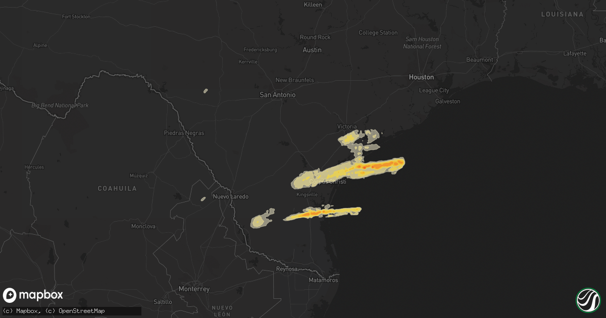
Hail Map on January 8, 2011
Get this storm
January 8 map
$229
one time, instant access
Download today. No call, no setup
Keep the $229
Bought the map and want the full workflow? Apply the entire $229 to a subscription within 7 days. None of it is wasted.
Every map, not just this one
This buys you this map. Subscription and you get every map we run, in the markets you choose from a few cities to whole states to nationwide. Plus real-time alerts the moment a storm fires.
Contact data
Name, contact info, occupancy, even credit band for addresses in the footprint. You go from where it hit to who to call.
Become the source they trust
Unlimited branding weather history reports on demand. You already have the documented answer ready for the property owner, and you are the one who showed up with it.
Property data and RoofTrace estimates
Pull up any address you have got, its value and the exact code rules for that jurisdiction, straight from One Click Code. Then RoofTrace estimates the squares, pitch, and roof value, priced the way you price.
States Impacted by Hail Map on January 8, 2011
Storm reports
Texas
| Date | Description |
|---|---|
| 01/08/20115:15 AM CST | Power lines down along cr 426 between cr 427 and fm 3131. |
| 01/08/20115:00 AM CST | Few asphalt shingles blown off residence. |
| 01/08/20114:48 AM CST | A large light pole was snapped at a baseball field near main street and houston avenue. An awning was blown off of a business and into boats at the marina in seadrift. |
| 01/08/20114:45 AM CST | Portion of roof blown off house and barn on highway 87 just south of fm 616. |
| 01/08/20114:45 AM CST | Power pole blown onto trailor home at 13000 block of highway 87 north. |
| 01/08/20114:40 AM CST | Car blown into ditch on highway 87 one mile north of 447. Driver reported a tornado. |
| 01/08/20114:40 AM CST | Guardrail damage to placedo bridge. Power lines down in the area and street signs down. |
| 01/08/20114:40 AM CST | Carport roof blown off of a home. Roof partially caved in and windows blown out of another home. A power pole was also blown down. A shed was blown into a neaby house a |
| 01/08/20114:40 AM CST | Car blown into ditch on highway 87 one mile north of 447. |
| 01/08/20114:40 AM CST | Portion of roof blown off house and barn on highway 87 just south of fm 616. Winds of 70 mph estimated by storm survey team. |
| 01/08/20114:30 AM CST | Roof damage to one home in rockport. A few trees were uprooted as well. Winds estimated at 75 mph. |
| 01/08/20114:30 AM CST | General public reported wind 75 mph. Roof or structural damage. Picked up a barn and turned it over. Lots of shingle damage. |
| 01/08/20114:24 AM CST | Nws employee reported trees and powerlines down on the west side of robstown. Sheet metal was wrapped around power poles. |
| 01/08/20114:24 AM CST | A local report indicates 1.00 inch wind near 1 NW ARANSAS PASS |
| 01/08/20114:10 AM CST | Nws storm survey team observed tree...sign...fence and power line damage in and northwest of portland. 3 mobile homes completely destroyed and several other damaged. Sh |
| 01/08/20114:00 AM CST | Public reported sheet metal damage to carport and aluminum siding blown off of house near the falfurrias airport. |
| 01/08/20113:54 AM CST | Semi truck flipped near the 5 points walmart in calallen. Street signs down. Shopping carts blown onto highway. |
| 01/08/20113:53 AM CST | Trained spotter reported est 60 mph winds |
| 01/08/20113:53 AM CST | Quarter sized hail within driscoll. Power outages also being reported. |
| 01/08/20113:52 AM CST | West side of robstown...trees and powerlines down. Sheet metal wrapped around power poles. |
| 01/08/20113:50 AM CST | Semi truck flipped near the 5 points walmart in calallen. Street signs down. Shopping carts blown onto highway. |
| 01/08/20113:45 AM CST | West side of robstown...trees and powerlines down. Sheet metal wrapped around power poles. Shingle and wooden roof damage to homes. Roof torn off robstown high school g |
| 01/08/20113:45 AM CST | Nws employee reported trees and powerlines down on the west side of robstown. Sheet metal was wrapped around power poles. |
| 01/08/20113:30 AM CST | A local report indicates 67 MPH wind near ALICE |
| 01/08/20113:25 AM CST | A nws storm survey concluded a long track tornado occurred across jim wells and nueces counties. The tornado began roughly 4 miles southeast of alice airport and ended |
| 01/08/201112:30 AM CST | A local report indicates 67 MPH wind near ALICE |
Cities Impacted by Hail Map on January 8, 2011
- Port O'Connor, TX
- Robstown, TX
- Beeville, TX
- Seadrift, TX
- Victoria, TX
- Tivoli, TX
- Bloomington, TX
- Port Lavaca, TX
- Placedo, TX
- Gregory, TX
- Sinton, TX
- Bishop, TX
- Aransas Pass, TX
- Ingleside, TX
- Corpus Christi, TX
- Orange Grove, TX
- Odem, TX
- Port Aransas, TX
- Mathis, TX
- Portland, TX
- Sandia, TX
- Rockport, TX
- Alice, TX
- Agua Dulce, TX
- Fulton, TX
- Taft, TX
- Zapata, TX
- Guerra, TX
- Hebbronville, TX
- Refugio, TX
- Sarita, TX
- Encino, TX
- Armstrong, TX
- Concepcion, TX
- Austwell, TX
- Matagorda, TX
- Goliad, TX
- Kingsville, TX
- Palacios, TX
- Lolita, TX
- Uvalde, TX
- San Diego, TX
- Benavides, TX