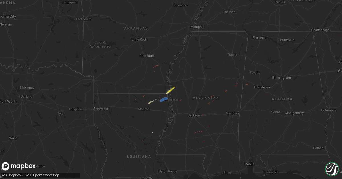
Hail Map on January 5, 2025
Get this storm
January 5 map
$229
one time, instant access
Download today. No call, no setup
Keep the $229
Bought the map and want the full workflow? Apply the entire $229 to a subscription within 7 days. None of it is wasted.
Every map, not just this one
This buys you this map. Subscription and you get every map we run, in the markets you choose from a few cities to whole states to nationwide. Plus real-time alerts the moment a storm fires.
Contact data
Name, contact info, occupancy, even credit band for addresses in the footprint. You go from where it hit to who to call.
Become the source they trust
Unlimited branding weather history reports on demand. You already have the documented answer ready for the property owner, and you are the one who showed up with it.
Property data and RoofTrace estimates
Pull up any address you have got, its value and the exact code rules for that jurisdiction, straight from One Click Code. Then RoofTrace estimates the squares, pitch, and roof value, priced the way you price.
States Impacted by Hail Map on January 5, 2025
Storm reports
Texas
| Date | Description |
|---|---|
| 01/05/202512:05 PM CST | Report of tree down on co rd 3022. |
| 01/05/202511:20 AM CST | Reports of several trees down along us-80. |
Alabama
| Date | Description |
|---|---|
| 01/04/20258:53 PM CST | An ef-1 tornado with maximum winds of 90 mph was confirmed. Path length was 6.94 miles. |
| 01/04/20258:05 PM CST | Tree down - time estimated from radar. |
| 01/04/20257:50 PM CST | Tree fell on house near county road 23 and ebenezer road. |
| 01/04/20257:44 PM CST | Trees down and barns/shed down on highway 23 in the hurricane creek community. Report relayed from social media. |
| 01/04/20257:42 PM CST | Corrects previous tstm wnd dmg report from 6 wsw vina. Tree fell on house near county road 23 and ebenezer road. |
| 01/04/20257:40 PM CST | An ef0 tornado touched down southwest of vina alabama near the mississippi border travelling northeast for 2.44 miles before lifting. Wind speeds estimated between 75 a |
| 01/04/20257:35 PM CST | Tree downed across n pike road in cherokee near the high school. Report from social media. |
Louisiana
| Date | Description |
|---|---|
| 01/05/20255:35 PM CST | 911 center reports tree on hwy 1 near echo. |
| 01/05/20255:30 PM CST | Utility company reports main line power pole broken. |
| 01/05/20254:47 PM CST | 911 center reports tree down on portions of hwy 165 in pineville. Time estimated by radar. |
| 01/05/20254:41 PM CST | 911 center reports tree across a roadway in the tioga community. |
| 01/05/20253:42 PM CST | Trees down on brown rd... Possible tornado. |
| 01/05/20253:42 PM CST | Corrects previous tornado report from 3 ne fiske union. This brief ef1 tornado touched down on abernathy road... Primarily snapping trees. It shifted a mobile home on m |
| 01/05/20253:34 PM CST | This brief ef1 tornado touched down on abernathy road... Primarily snapping trees. It shifted a mobile home on myers road... With no injuries. Most trees that were snap |
| 01/05/20253:05 PM CST | Tree damage reported at the intersection of la hwy 134 and la hwy 139. Time estimated by radar. |
| 01/05/20253:00 PM CST | Emergency manager reported trees and powerlines were down near new fellowship church along hwy 139 and south of bastrop. |
| 01/05/20252:35 PM CST | Satellite imagery indicates the union parish ef-2 tornado path continued a short distance into northwestern morehouse parish over the upper ouachita national wildlife r |
| 01/05/20252:25 PM CST | Fd report of a house and shop with damage... Multiple trees down. Time estimated by radar. Tornado possible. |
| 01/05/20252:19 PM CST | On january 5... 2025 an ef2 tornado moved through portions of union parish in louisiana. The tornado began on cable lane road... Southeast of marion at approximately 20 |
| 01/05/20252:19 PM CST | Corrects previous tornado report from 4 se marion. On january 5... 2025 an ef2 tornado moved through portions of union parish in louisiana. The tornado began on cable l |
| 01/05/20251:58 PM CST | Law enforcement received report of tree downed along side of parish rd in lincoln parish. |
| 01/05/20251:15 PM CST | Tree reported down in ringgold. |
| 01/05/20251:01 PM CST | A tree was downed on the porch of a home off of menyfield road in calhoun... Louisiana. |
| 01/05/202512:55 PM CST | Large tree limbs reported down in the road in doyline. |
| 01/05/202512:40 PM CST | Large tree limbs reported down in cotton valley. Time estimated by radar. |
| 01/05/202512:10 PM CST | Tree blown down at the 7100 block of north lakeshore drive. |
Arkansas
| Date | Description |
|---|---|
| 01/05/20252:05 PM CST | Video from a local firefighter shows a tornado near this location. Radar confirmed tds was observed nearby as well. |
| 01/05/20252:05 PM CST | Some tree and mostly minor structural damage was found along grangeway road. Two chicken houses were affected... As well as roofs on at least a couple of homes. |
| 01/05/202510:41 AM CST | Report of multiple trees down south of us-67 in perrytown... Ar. |
Mississippi
| Date | Description |
|---|---|
| 01/05/20255:55 PM CST | A few trees down. |
| 01/05/20255:45 PM CST | Scattered trees down in the n portion of the county... Some across roads. |
| 01/05/20255:44 PM CST | A few power lines were down in town. |
| 01/05/20255:44 PM CST | Corrects previous tornado report from louise. A few power lines were down in town. |
| 01/05/20255:20 PM CST | Couple trees down at us hwy 82 and cr 321. Tree was across the w bound lane and a car ran into the tree. |
| 01/05/20253:34 PM CST | Several large softwood branches down along highway 4. |
| 01/05/20253:33 PM CST | Several tree tops split off trees near little texas. Debris blocked roadway. |
| 01/05/20253:31 PM CST | Minor siding damage to side of home. |
| 01/04/20258:52 PM CST | This tornado began along county road 108 northwest of shady grove where a home suffered generally minor damage to gutters and flashing and a couple of trees were downed |
| 01/04/20258:47 PM CST | Emergency manager reported trees and power lines down near sonat rd in the will barber area. |
| 01/04/20258:38 PM CST | A tree was downed at us 80 and mcmillian rd. |
| 01/04/20258:31 PM CST | This tornado touched down near the community of gwinville. Along its path... It uprooted softwood trees and broke large branches. An abandoned building was damaged. An |
| 01/04/20258:27 PM CST | Trees and power lines down near hwy 80. |
| 01/04/20258:18 PM CST | This weak tornado touched down just south of sills ferry road. Along its path... It blew down weak and dead trees... Did minor roof damage to a house... And tossed a tr |
| 01/04/20258:13 PM CST | Powerlines and poles down. |
| 01/04/20258:11 PM CST | This tornado started just west of highway 45 north of brooksville snapping a few trees. The tornado continued northeast across highway 45 snapping and uprooting numerou |
| 01/04/20257:52 PM CST | Emergency manager reported multiple trees down in that area and some on houses on highway 14 east of louisville. Possible tornado. |
| 01/04/20257:42 PM CST | Corrects previous tornado report from 1 sw boon. Corrects previous tornado report from 1 sw boon. This ef1 tornado began just west of jack warner road... Where it snapp |
| 01/04/20257:42 PM CST | Emergency manager reported power lines down and da |
| 01/04/20257:42 PM CST | Emergency manager reported power lines down and damage to buildings at crystal ridge road/boone road area. Possible tornado. |
| 01/04/20257:40 PM CST | Corrects previous tornado report from 1 sw boon. This ef1 tornado began just west of jack warner road... Where it snapped a few trees and caused damage to the roof of a |
| 01/04/20257:20 PM CST | Minor damaged was sustained to a home and trees along pecan rd. |
| 01/04/20257:20 PM CST | Corrects previous tornado report from 2 wsw pelahatchie. Trees and power lines down near hwy 80. |
| 01/04/20257:11 PM CST | This tornado touched down just north of shilo road and tracked ne for 11 miles before dissipating just past leesburg road. Much of the damage along the path was damaged |
| 01/04/20257:10 PM CST | Report from mping of wind damage similar to 1-inch tree limbs broken or shingles blown off a house. |
| 01/04/20257:09 PM CST | Powerlines down at the intersection of old houston road and egypt road. Time is radar estimated. |
| 01/04/20257:08 PM CST | A brief ef1 tornado damaged power lines and trees near the intersection of old houston road and egypt road. A few homes sustained damage on egypt road. |
| 01/04/20257:00 PM CST | A tree fell through a house along harbor road. |
| 01/04/20256:48 PM CST | Corrects previous tstm wnd dmg report from thomastown. Emergency manager reported trees down at hwy 429 and hwy 43... Tree down in power line on hwy 429 near thomastown |
| 01/04/20256:30 PM CST | Tree down on red dog rd near carthage and tree down on north pearl st. |
| 01/04/20256:27 PM CST | Emergency manager reported trees down at hwy 429 and hwy 43... Tree down in power line on hwy 429 near thomastown... Trees down on red dog rd near carthage and tree dow |
| 01/04/20256:05 PM CST | Couple trees down in the nw part of the county. |
Cities Impacted by Hail Map on January 5, 2025
- Jonesboro, LA
- Bastrop, LA
- Collinston, LA
- Monticello, AR
- Grady, AR
- Dumas, AR
- Eudora, AR
- Greenville, MS
- Chatham, MS
- Hollandale, MS
- Glen Allan, MS
- Mer Rouge, LA
- Pioneer, LA
- Oak Grove, LA
- Lake Providence, LA
- Harrisonburg, LA
- Jonesville, LA
- Carthage, MS
- Kosciusko, MS
- Brandon, MS
- Crawford, MS
- Brooksville, MS
- Louisville, MS
- Newhebron, MS
- Magee, MS
- Mize, MS
- Carrollton, AL
- Reform, AL
- Carson, MS
- Aberdeen, MS
- Meadville, MS
- McCall Creek, MS
- Brookhaven, MS