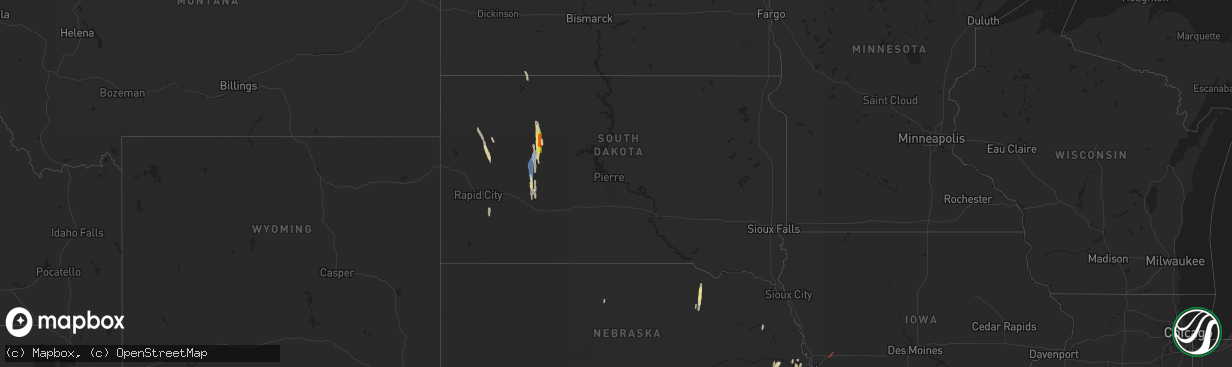
Hail Map in South Dakota on May 6, 2024
The weather event in South Dakota on May 6, 2024 includes Hail, Wind, and Tornado maps. 16 states and 1,500 cities were impacted and suffered possible damage. The total estimated number of properties impacted is 86.
Hail
Wind
Tornado
86
Estimated number of impacted properties by a 1.00" hail or larger20
Estimated number of impacted properties by a 1.75" hail or larger0
Estimated number of impacted properties by a 2.50" hail or largerStorm reports in South Dakota
South Dakota
| Date | Description |
|---|---|
| 05/06/20243:18 PM CDT | A local report indicates 68 MPH wind near 15 SSE Mission |
| 05/06/20242:20 PM CDT | Wind still gusting over 60 mph. |
| 05/06/20242:07 PM CDT | Second touchdown of the tornado west of mud butte. |
| 05/06/20241:49 PM CDT | Tornado on the ground for about 5 minutes. Started south of highway 212 and appeared to cross highway 212. Tornado lifted on the north side of highway 212. |
| 05/05/20248:17 PM CDT | Multiple tree branches |
| 05/05/20248:15 PM CDT | Hoop house blown over and multiple large tree branches down. Report via social media with time estimated using radar. |
| 05/05/20248:09 PM CDT | Report of a tree down... With a couple sizeable branches down as well. Recieved report via facebook. |
| 05/05/20247:31 PM CDT | Very strong wind gusts measured by mobile mesonet... Along with heavy rain. |
All States Impacted by Hail Map on May 6, 2024
Cities Impacted by Hail Map on May 6, 2024
- Hoxie, KS
- Hermosa, SD
- Caputa, SD
- Jennings, KS
- Clayton, KS
- Norton, KS
- Penokee, KS
- Morland, KS
- Wilsonville, NE
- Hendley, NE
- Beaver City, NE
- Hill City, KS
- Lenora, KS
- Almena, KS
- Logan, KS
- Edison, NE
- Oxford, NE
- Wakeeney, KS
- Collyer, KS
- Arapahoe, NE
- Hammond, MT
- Boyes, MT
- Ekalaka, MT
- Prairie View, KS
- Louisville, GA
- Phillipsburg, KS
- Newell, SD
- Bogue, KS
- Quinn, SD
- Stockton, KS
- Long Island, KS
- Blythe, GA
- Augusta, GA
- Damar, KS
- Utica, KS
- Palco, KS
- Alma, NE
- Philip, SD
- Wall, SD
- Ogallah, KS
- Ellis, KS
- Spearville, KS
- Republican City, NE
- Wright, KS
- Ford, KS
- Harlem, GA
- Grovetown, GA
- Nicholson, GA
- Jefferson, GA
- Athens, GA
- Glade, KS
- Hayesville, NC
- Dodge City, KS
- Bucklin, KS
- Plainville, KS
- Offerle, KS
- Kinsley, KS
- Morrison, TN
- Altamont, TN
- Naponee, NE
- Mud Butte, SD
- Mountain Rest, SC
- Mcminnville, TN
- Beersheba Springs, TN
- Lewis, KS
- Hull, GA
- Lebanon, TN
- Colbert, GA
- Milesville, SD
- Cherry Creek, SD
- Linden, TN
- Mount Juliet, TN
- Salem, SC
- Tamassee, SC
- Howes, SD
- Agra, KS
- Kensington, KS
- Bloomington, NE
- Smith Center, KS
- Lobelville, TN
- Centerville, TN
- Bon Aqua, TN
- Lyles, TN
- Kirwin, KS
- North Augusta, SC
- Walhalla, SC
- Pickens, SC
- Woodston, KS
- Fairview, TN
- Franklin, TN
- Primm Springs, TN
- Garfield, KS
- Larned, KS
- Franklin, NE
- Riverton, NE
- Alton, KS
- Gaylord, KS
- Hays, KS
- Bethpage, TN
- Castalian Springs, TN
- Greensburg, KS
- Hartsville, TN
- Watertown, TN
- Tallahassee, FL
- Comer, GA
- Martin, GA
- Westminster, SC
- Toccoa, GA
- Cedar, KS
- Pawnee Rock, KS
- Protection, KS
- Coldwater, KS
- Murfreesboro, TN
- Athol, KS
- Gordonsville, TN
- Carthage, TN
- Thompsons Station, TN
- Murphy, NC
- Sunset, SC
- Six Mile, SC
- Edgefield, SC
- Easley, SC
- Inavale, NE
- Saluda, SC
- Johnston, SC
- Haviland, KS
- Alzada, MT
- Ewing, NE
- Matthews, GA
- Liberty, SC
- Catharine, KS
- Brush Creek, TN
- Albert, KS
- Otis, KS
- Natoma, KS
- Riddleton, TN
- Campbell, NE
- College Grove, TN
- Duck River, TN
- Hampshire, TN
- Williamsport, TN
- Mount Pleasant, TN
- Lebanon, KS
- Faith, SD
- Dupree, SD
- Inman, NE
- Sharon, OK
- Portis, KS
- Buffalo Valley, TN
- Page, NE
- Great Bend, KS
- Bladen, NE
- Elmwood, TN
- Chestnut Mound, TN
- Arnett, OK
- Thedford, NE
- Columbia, TN
- Woodward, OK
- Arrington, TN
- Rockvale, TN
- Eagleville, TN
- Orchard, NE
- Oneill, NE
- Red Cloud, NE
- Wilmore, KS
- Hoisington, KS
- Central, SC
- Waterford, MS
- Potts Camp, MS
- Greenville, SC
- Mooreland, OK
- Blue Hill, NE
- Burr Oak, KS
- Esbon, KS
- Mankato, KS
- Guide Rock, NE
- Glenvil, NE
- Ayr, NE
- Lawrence, NE
- St John, KS
- Smithville, TN
- Pratt, KS
- Byers, KS
- Iuka, KS
- Capitol, MT
- Piedmont, SC
- Nashville, TN
- Sylvania, GA
- Fairfax, SC
- Cheyenne, OK
- Claflin, KS
- Vici, OK
- Pendleton, SC
- Anderson, SC
- Antioch, TN
- Crawford, OK
- Liberty, TN
- Dowelltown, TN
- Demorest, GA
- Seneca, SC
- Baxter, TN
- Cookeville, TN
- Coats, KS
- Waynoka, OK
- Mutual, OK
- Williamston, SC
- Hammon, OK
- Pelzer, SC
- Leedey, OK
- Gatlinburg, TN
- Sparta, TN
- Sun City, KS
- Christiana, TN
- Hermitage, TN
- Inland, NE
- Hastings, NE
- Trumbull, NE
- Superior, NE
- Fairfield, NE
- Giltner, NE
- Deweese, NE
- Harvard, NE
- Nelson, NE
- Clay Center, NE
- Ellinwood, KS
- Holyrood, KS
- Bushton, KS
- Lorraine, KS
- Simpsonville, SC
- Smoaks, SC
- Ruffin, SC
- Gray Court, SC
- Fountain Inn, SC
- Stafford, KS
- Macksville, KS
- Woodruff, SC
- Only, TN
- McEwen, TN
- Nunnelly, TN
- Silver Point, TN
- Walling, TN
- Luray, SC
- Estill, SC
- Chester, OK
- Bell Buckle, TN
- Fairview, OK
- Alva, OK
- Taloga, OK
- Edgar, NE
- Camargo, OK
- Cosby, TN
- Sevierville, TN
- Turon, KS
- Beechgrove, TN
- Henderson, NE
- Stromsburg, NE
- Sutton, NE
- Bradshaw, NE
- Aurora, NE
- Benedict, NE
- Oak, NE
- Polk, NE
- Saronville, NE
- Hampton, NE
- Bradyville, TN
- Manchester, TN
- Geneva, NE
- Shickley, NE
- Ong, NE
- Davenport, NE
- Grafton, NE
- McCool Junction, NE
- Ruskin, NE
- Fairmont, NE
- York, NE
- Deshler, NE
- Ellsworth, KS
- Sylvia, KS
- Lincoln, KS
- Lyons, KS
- Quebeck, TN
- Doyle, TN
- Enoree, SC
- Mauldin, SC
- Plevna, KS
- Seiling, OK
- Ridgeland, SC
- Newport, TN
- Oakwood, OK
- Kanopolis, KS
- Walterboro, SC
- Winnsboro, SC
- Spencer, TN
- Abbyville, KS
- Sterling, KS
- Cleo Springs, OK
- Aline, OK
- Orangeburg, SC
- Cottageville, SC
- Ridgeville, SC
- Union, SC
- Clinton, SC
- Osceola, NE
- Gresham, NE
- Shelby, NE
- Waco, NE
- Carmen, OK
- Belvidere, NE
- Bruning, NE
- Strang, NE
- Carleton, NE
- Hebron, NE
- Hardy, NE
- Helena, OK
- Canton, OK
- Saint George, SC
- Tescott, KS
- Brookville, KS
- Whitmire, SC
- Commerce, GA
- Concordia, KS
- Aurora, KS
- Butler, OK
- Sawyer, KS
- Nickerson, KS
- Bells, TN
- Gadsden, TN
- Ohiowa, NE
- Exeter, NE
- Milligan, NE
- Longdale, OK
- Southard, OK
- Belleville, KS
- Clyde, KS
- Agenda, KS
- Clifton, KS
- Goltry, OK
- Jet, OK
- Miltonvale, KS
- Minneapolis, KS
- Delphos, KS
- Guyton, GA
- Laurens, SC
- Salina, KS
- Windom, KS
- Inman, KS
- Hutchinson, KS
- Little River, KS
- Greeneville, TN
- Putnam, OK
- Marshall, NC
- Hillsboro, TN
- Nash, OK
- Pond Creek, OK
- Okeene, OK
- Isabella, OK
- Lemmon, SD
- Watonga, OK
- Mcpherson, KS
- Lindsborg, KS
- Tillman, SC
- Hardeeville, SC
- Sayre, OK
- Lucas, KS
- Osborne, KS
- Luray, KS
- Bennington, KS
- Wisner, NE
- Clay Center, KS
- Marquette, KS
- Hitchcock, OK
- Custer City, OK
- Kingfisher, OK
- Gypsum, KS
- Hettinger, ND
- Afton, TN
- Chuckey, TN
- Bloomingdale, GA
- Spring Hill, TN
- Elk City, OK
- Assaria, KS
- Galva, KS
- Solomon, KS
- Linn, KS
- Hennessey, OK
- Ames, OK
- Abilene, KS
- Hope, KS
- Drummond, OK
- Waukomis, OK
- Chapman, KS
- Enterprise, KS
- Medford, OK
- Tampa, KS
- Durham, KS
- Enid, OK
- Washington, KS
- Morganville, KS
- Rincon, GA
- Ellabell, GA
- New Cambria, KS
- Limestone, TN
- Telford, TN
- Talmage, KS
- Woodbine, KS
- Wakefield, KS
- Clinton, OK
- Arapaho, OK
- Weatherford, OK
- Junction City, KS
- Dwight, NE
- Palmer, KS
- Longford, KS
- Bison, OK
- Lewisburg, TN
- Port Wentworth, GA
- Florence, SC
- Scooba, MS
- Abbeville, SC
- Donalds, SC
- Fort Riley, KS
- Milford, KS
- Riley, KS
- Lamont, OK
- Deer Creek, OK
- Manhattan, KS
- Ogden, KS
- Randolph, KS
- Leonardville, KS
- Thomas, OK
- Odell, NE
- Wymore, NE
- Blue Springs, NE
- Weston, NE
- Prague, NE
- Valparaiso, NE
- Malmo, NE
- Honea Path, SC
- Greenleaf, KS
- Barnard, KS
- Beatrice, NE
- Chapel Hill, TN
- Lascassas, TN
- Granite Falls, NC
- Nardin, OK
- Marshall, OK
- Douglas, OK
- Fairmont, OK
- Olsburg, KS
- Blue Rapids, KS
- Colon, NE
- Cedar Bluffs, NE
- Hodges, SC
- Waterville, KS
- Barnes, KS
- Adams, NE
- Filley, NE
- Virginia, NE
- Readyville, TN
- Blackwell, OK
- Braman, OK
- Saint George, KS
- Frankfort, KS
- Westmoreland, KS
- Covington, OK
- Lucien, OK
- Orlando, OK
- Vermillion, KS
- Axtell, KS
- Ames, NE
- South Haven, KS
- Oxford, KS
- Geuda Springs, KS
- Glasco, KS
- Beloit, KS
- Cedar Vale, KS
- Taylorsville, NC
- Beverly, KS
- Ware Shoals, SC
- Oketo, KS
- Pigeon Forge, TN
- Woodbury, TN
- Perry, OK
- Waterloo, SC
- Unadilla, NE
- Newkirk, OK
- Arkansas City, KS
- Belton, SC
- Winfield, KS
- Lincoln, NE
- Bethune, SC
- Kershaw, SC
- Chase, KS
- Geary, OK
- Grenola, KS
- Cambridge, KS
- Dexter, KS
- Severy, KS
- Onaga, KS
- Rock, KS
- Baileyville, KS
- West Union, SC
- Greenfield, OK
- Loyal, OK
- Table Rock, NE
- Johnson, NE
- Humboldt, NE
- Auburn, NE
- Shidler, OK
- Geneseo, KS
- Cushing, OK
- Lenoir, NC
- Statesville, NC
- Stony Point, NC
- Dandridge, TN
- Brentwood, TN
- Syracuse, NE
- Avoca, NE
- Elmwood, NE
- Weeping Water, NE
- Lancaster, TN
- Seneca, KS
- Goff, KS
- Corning, KS
- Centralia, KS
- Home, KS
- Marysville, KS
- Summerfield, KS
- Liberty, NE
- Steinauer, NE
- Beattie, KS
- Burchard, NE
- Du Bois, NE
- Pawnee City, NE
- Green, KS
- Tecumseh, NE
- Crab Orchard, NE
- La Vista, NE
- Papillion, NE
- Omaha, NE
- Springfield, NE
- Yale, OK
- Brock, NE
- Omega, OK
- Valley, NE
- Okarche, OK
- Calumet, OK
- Elkhorn, NE
- Bennington, NE
- Cross Hill, SC
- Kennard, NE
- Bern, KS
- Sterling, NE
- Falun, KS
- Panama, NE
- Walton, NE
- Hickman, NE
- Roca, NE
- Bennet, NE
- Firth, NE
- Palmyra, NE
- Douglas, NE
- Waverly, NE
- Pickrell, NE
- Eagle, NE
- Burr, NE
- Murdock, NE
- Ceresco, NE
- Alvo, NE
- Wahoo, NE
- Ashland, NE
- Ithaca, NE
- Greenwood, NE
- Gretna, NE
- Mead, NE
- Dunbar, NE
- Manley, NE
- South Bend, NE
- Glenwood, IA
- Otoe, NE
- Nebraska City, NE
- Nehawka, NE
- Murray, NE
- Union, NE
- Yutan, NE
- Memphis, NE
- Pacific Junction, IA
- Cedar Creek, NE
- Plattsmouth, NE
- Louisville, NE
- Bellevue, NE
- Waterloo, NE
- Council Bluffs, IA
- Boys Town, NE
- Crescent, IA
- Offutt Afb, NE
- Fort Calhoun, NE
- Carter Lake, IA
- Blair, NE
- Washington, NE
- Cook, NE
- Hamburg, IA
- Lorton, NE
- Sidney, IA
- Talmage, NE
- Thurman, IA
- Percival, IA
- Tabor, IA
- Mountville, SC
- Shenandoah, IA
- Dawson, NE
- Stella, NE
- Verdon, NE
- Fort Stewart, GA
- Hiddenite, NC
- Norris, SC
- Sabetha, KS
- Oneida, KS
- Terlton, OK
- Rock Port, MO
- Brownville, NE
- Nemaha, NE
- Peru, NE
- Elk Creek, NE
- Julian, NE
- Riverton, IA
- Shubert, NE
- Morrill, KS
- Salem, NE
- Watson, MO
- Falls City, NE
- Cleveland, OK
- Logan, IA
- Honey Creek, IA
- Underwood, IA
- Malvern, IA
- Missouri Valley, IA
- Silver City, IA
- Hastings, IA
- Oakland, IA
- Randolph, IA
- McClelland, IA
- Mineola, IA
- Henderson, IA
- Minden, IA
- Emerson, IA
- Macedonia, IA
- Treynor, IA
- Carson, IA
- Neola, IA
- Imogene, IA
- Farragut, IA
- Tarkio, MO
- Westboro, MO
- Fairfax, MO
- Osage, OK
- Hominy, OK
- Townville, SC
- Arlington, NE
- Fleming, GA
- Fairfax, OK
- Pawnee, OK
- Howard, KS
- Fall River, KS
- Stillwater, OK
- Sedan, KS
- Shelby, IA
- Northboro, IA
- Coin, IA
- Craig, MO
- Blanchard, IA
- Essex, IA
- Red Oak, IA
- Hancock, IA
- Walnut, IA
- Persia, IA
- Griswold, IA
- Elliott, IA
- Avoca, IA
- Woodbine, IA
- Harlan, IA
- Earling, IA
- Panama, IA
- Dunlap, IA
- Portsmouth, IA
- Burden, KS
- Atlanta, KS
- Latham, KS
- Piedmont, KS
- Eureka, KS
- Richmond Hill, GA
- Wellsville, KS
- Barnsdall, OK
- Crescent, OK
- Moline, KS
- Elk Falls, KS
- Independence, KS
- Longton, KS
- Elk City, KS
- Caney, KS
- Niotaze, KS
- Peru, KS
- Havana, KS
- Bartlesville, OK
- Manilla, IA
- Irwin, IA
- Westphalia, IA
- Defiance, IA
- Kirkman, IA
- Brayton, IA
- Atlantic, IA
- Exira, IA
- Audubon, IA
- Marne, IA
- Kimballton, IA
- Elk Horn, IA
- Lewis, IA
- Wiota, IA
- Clarinda, IA
- Grant, IA
- Yorktown, IA
- Villisca, IA
- Corning, IA
- Cumberland, IA
- Stanton, IA
- Braddyville, IA
- College Springs, IA
- Elmo, MO
- Cleveland, NC
- Dobson, NC
- Cashion, OK
- Eudora, KS
- Fredonia, KS
- Neal, KS
- Toronto, KS
- Virgil, KS
- Neosho Falls, KS
- Buffalo, KS
- Neodesha, KS
- Yates Center, KS
- Le Roy, KS
- Benedict, KS
- Gridley, KS
- Burlington, KS
- Piqua, KS
- Cherryvale, KS
- Thayer, KS
- Chanute, KS
- Mound Valley, KS
- Coffeyville, KS
- Liberty, KS
- Tyro, KS
- Altoona, KS
- Dearing, KS
- Edna, KS
- Parsons, KS
- Dennis, KS
- Altamont, KS
- Galesburg, KS
- Humboldt, KS
- Iola, KS
- Dewey, OK
- Erie, KS
- Girard, KS
- Savonburg, KS
- McCune, KS
- Columbus, KS
- Walnut, KS
- West Mineral, KS
- Chetopa, KS
- Scammon, KS
- Saint Paul, KS
- Colony, KS
- Oswego, KS
- Mapleton, KS
- Moran, KS
- Redfield, KS
- Uniontown, KS
- Weir, KS
- Pittsburg, KS
- Mound City, KS
- Welda, KS
- Fort Scott, KS
- Kincaid, KS
- Hepler, KS
- Bronson, KS
- Farlington, KS
- Westphalia, KS
- Stark, KS
- Blue Mound, KS
- La Harpe, KS
- Elsmore, KS
- Cherokee, KS
- Centerville, KS
- Garnett, KS
- Wynona, OK
- Guthrie, OK
- Pawhuska, OK
- Mulhall, OK
- Edmond, OK
- Carroll, IA
- Wall Lake, IA
- Arcadia, IA
- Vail, IA
- Sac City, IA
- Westside, IA
- Manning, IA
- Lake View, IA
- Breda, IA
- Halbur, IA
- Aspinwall, IA
- Templeton, IA
- Auburn, IA
- Denison, IA
- Gray, IA
- Dow City, IA
- Anita, IA
- Coon Rapids, IA
- Guthrie Center, IA
- Dedham, IA
- Adair, IA
- Hamlin, IA
- Bridgewater, IA
- Carbon, IA
- Fontanelle, IA
- Nodaway, IA
- Massena, IA
- New Market, IA
- Gravity, IA
- Prescott, IA
- Shambaugh, IA
- Lenox, IA
- Skidmore, MO
- Burlington Junction, MO
- Clearmont, MO
- Rulo, NE
- Bedford, IA
- Coyle, OK
- Ochelata, OK
- Meridian, OK
- Muskogee, OK
- Dover, OK
- Skiatook, OK
- Ramona, OK
- Talala, OK
- Wagoner, OK
- Perkins, OK
- Wellston, OK
- Nowata, OK
- Delaware, OK
- Ottawa, KS
- Rantoul, KS
- Porter, OK
- Carney, OK
- Tryon, OK
- Carnegie, OK
- Fort Cobb, OK
- Galena, KS
- Locust Grove, OK
- Cordell, OK
- Roosevelt, OK
- Agra, OK
- Gracemont, OK
- Binger, OK
- Anadarko, OK
- Lidderdale, IA
- Palmer, IA
- Jolley, IA
- Rockwell City, IA
- Glidden, IA
- Fonda, IA
- Pocahontas, IA
- Lake City, IA
- Lanesboro, IA
- Lohrville, IA
- Manson, IA
- Lytton, IA
- Pomeroy, IA
- Sharpsburg, IA
- Casey, IA
- Greenfield, IA
- Creston, IA
- Orient, IA
- Stuart, IA
- Churdan, IA
- Menlo, IA
- Gowrie, IA
- Jefferson, IA
- Bagley, IA
- Yale, IA
- Bayard, IA
- Panora, IA
- Ralston, IA
- Scranton, IA
- Somers, IA
- Paton, IA
- Farnhamville, IA
- Chandler, OK
- Stroud, OK
- Salina, OK
- Rose, OK
- Eucha, OK
- Jennings, OK
- Drumright, OK
- Welch, OK
- Colcord, OK
- Arcadia, OK
- Luther, OK
- Mountain View, OK
- Greeley, KS
- Lane, KS
- Richmond, KS
- Baldwin City, KS
- Williamsburg, KS
- Princeton, KS
- Parker, KS
- Waverly, KS
- Lenapah, OK
- S Coffeyville, OK
- Wann, OK
- Bronaugh, MO
- Amoret, MO
- Vinita, OK
- Mulberry, KS
- Arma, KS
- Osawatomie, KS
- Fontana, KS
- Bartlett, KS
- Deerfield, MO
- Fulton, KS
- Pleasanton, KS
- La Cygne, KS
- Paola, KS
- Copan, OK
- Franklin, KS
- Liberal, MO
- Rich Hill, MO
- Prescott, KS
- Butler, MO
- Mindenmines, MO
- Frontenac, KS
- Foster, MO
- Amsterdam, MO
- Richards, MO
- Hume, MO
- Arcadia, KS
- Garland, KS
- Baxter Springs, KS
- Chelsea, OK
- Bluejacket, OK
- Miami, OK
- Afton, OK
- Moundville, MO
- Treece, KS
- Asbury, MO
- North Miami, OK
- Nevada, MO
- Opolis, KS
- Commerce, OK
- Picher, OK
- Adair, OK
- Big Cabin, OK
- Riverton, KS
- Joplin, MO
- Carl Junction, MO
- Fairland, OK
- Wyandotte, OK
- Quapaw, OK
- New Century, KS
- Olathe, KS
- Mission, KS
- Louisburg, KS
- Edgerton, KS
- Gardner, KS
- Bonner Springs, KS
- Stilwell, KS
- Belton, MO
- Kansas City, KS
- Lenexa, KS
- Linwood, KS
- Basehor, KS
- Leawood, KS
- De Soto, KS
- Cleveland, MO
- Kansas City, MO
- Spring Hill, KS
- Bucyrus, KS
- Adrian, MO
- Peculiar, MO
- Drexel, MO
- Prairie Village, KS
- Freeman, MO
- Shawnee, KS
- Overland Park, KS
- Callender, IA
- Clare, IA
- Barnum, IA
- Moorland, IA
- Knierim, IA
- Gilmore City, IA
- Jay, OK
- Glencoe, OK
- Spavinaw, OK
- Curlew, IA
- Tahlequah, OK
- Mannford, OK
- Minco, OK
- Ripley, OK
- Lookeba, OK
- Davenport, OK
- Grandview, MO
- Independence, MO
- Lees Summit, MO
- Pleasant Hill, MO
- Archie, MO
- Harrisonville, MO
- Raymore, MO
- Greenwood, MO
- Blue Springs, MO
- Garden City, MO
- East Lynne, MO
- Grain Valley, MO
- Creighton, MO
- Pocasset, OK
- Mallard, IA
- Emmetsburg, IA
- Kansas, OK
- Twin Oaks, OK
- Sand Springs, OK
- Jones, OK
- Proctor, OK
- Tuttle, OK
- Blanchard, OK
- Newcastle, OK
- Oklahoma City, OK
- Mustang, OK
- Union City, OK
- Yukon, OK
- Wheatland, OK
- Depew, OK
- Tulsa, OK
- Union Star, MO
- King City, MO
- Decatur, AR
- Gravette, AR
- Maysville, AR
- Gentry, AR
- Noel, MO
- Loveland, OK
- Bristow, OK
- Choctaw, OK
- Spencer, OK
- Harrah, OK
- Newalla, OK
- Walters, OK
- Norman, OK
- Bella Vista, AR
- Pineville, MO
- Carthage, MO
- Oronogo, MO
- Seneca, MO
- Webb City, MO
- Diamond, MO
- Carterville, MO
- Duenweg, MO
- Neosho, MO
- Jasper, MO
- Granby, MO
- Stotts City, MO
- Brighton, MO
- Warsaw, MO
- Arcola, MO
- Strasburg, MO
- Fair Play, MO
- Bolivar, MO
- Warrensburg, MO
- Sarcoxie, MO
- Clever, MO
- Chilhowee, MO
- Stockton, MO
- Willard, MO
- Blairstown, MO
- Marionville, MO
- Lincoln, MO
- Rockville, MO
- Fair Grove, MO
- Pierce City, MO
- Mount Vernon, MO
- Nixa, MO
- Osceola, MO
- Monett, MO
- Billings, MO
- Buckner, MO
- Appleton City, MO
- Clinton, MO
- Oak Grove, MO
- Cross Timbers, MO
- Windsor, MO
- Ash Grove, MO
- Edwards, MO
- Alba, MO
- Lone Jack, MO
- Urich, MO
- Avilla, MO
- Knob Noster, MO
- Montrose, MO
- Collins, MO
- Purcell, MO
- Verona, MO
- Schell City, MO
- Milo, MO
- Louisburg, MO
- Hermitage, MO
- Sheldon, MO
- Preston, MO
- Dadeville, MO
- Reeds, MO
- Morrisville, MO
- Weaubleau, MO
- Centerview, MO
- Lowry City, MO
- Walnut Grove, MO
- Aldrich, MO
- South Greenfield, MO
- Quincy, MO
- Freistatt, MO
- Pittsburg, MO
- Aurora, MO
- Golden City, MO
- Lamar, MO
- Walker, MO
- Deepwater, MO
- Half Way, MO
- Bois D Arc, MO
- La Russell, MO
- Greenfield, MO
- Republic, MO
- Urbana, MO
- Humansville, MO
- Pleasant Hope, MO
- Odessa, MO
- Lockwood, MO
- Leeton, MO
- Green Ridge, MO
- Miller, MO
- Calhoun, MO
- Dunnegan, MO
- Brookline, MO
- Flemington, MO
- Buffalo, MO
- Bates City, MO
- Wentworth, MO
- Harwood, MO
- Neck City, MO
- Holden, MO
- El Dorado Springs, MO
- Everton, MO
- Halltown, MO
- Jerico Springs, MO
- Polk, MO
- Kingsville, MO
- Springfield, MO
- Wheatland, MO
- Higginsville, MO
- Shawnee, OK
- Mcloud, OK
- Meeker, OK
- Jenks, OK
- Broken Arrow, OK
- Catoosa, OK
- Stella, MO
- Geronimo, OK
- Powell, MO
- Rocky Comfort, MO
- Washington, OK
- Okemah, OK
- Castle, OK
- Murray, IA
- Lorimor, IA
- Noble, OK
- Okmulgee, OK
- Beggs, OK
- Tecumseh, OK
- Fairview, MO
- Wheaton, MO
- Earlsboro, OK
- Purcell, OK
- Seminole, OK
- Morris, OK
- Duncan, OK
- Boynton, OK
- Chouteau, OK
- Oktaha, OK
- Haskell, OK
- Purdy, MO
- Wewoka, OK
- Harleyville, SC
- Crane, MO
- Taft, OK
- Fort Gibson, OK
- Highlandville, MO
- Oaks, OK
- Checotah, OK
- Peggs, OK
- Sparta, MO
- Council Hill, OK
- Cape Fair, MO
- Braggs, OK
- Park Hill, OK
- Wellington, MO
- Lexington, MO
- Mayview, MO
- Sibley, MO
- Napoleon, MO
- Corder, MO
- Whiteman Air Force Base, MO
- Concordia, MO
- Sedalia, MO
- Levasy, MO
- Cole Camp, MO
- Alma, MO
- Ionia, MO
- Henrietta, MO
- Malta Bend, MO
- Houstonia, MO
- Camden, MO
- Sweet Springs, MO
- Marshall, MO
- Hughesville, MO
- Blackburn, MO
- Orrick, MO
- La Monte, MO
- Otterville, MO
- Nelson, MO
- Stover, MO
- Mora, MO
- Smithton, MO
- Blackwater, MO
- Pilot Grove, MO
- Slater, MO
- Florence, MO
- Russellville, MO
- Latham, MO
- Auxvasse, MO
- Camdenton, MO
- Harrisburg, MO
- Fortuna, MO
- Fayette, MO
- Higbee, MO
- New Franklin, MO
- Sunrise Beach, MO
- Arrow Rock, MO
- Barnett, MO
- Boonville, MO
- Bunceton, MO
- Rocheport, MO
- Sturgeon, MO
- Franklin, MO
- Syracuse, MO
- Centralia, MO
- Prairie Home, MO
- Versailles, MO
- Ashland, MO
- Macks Creek, MO
- Roach, MO
- Climax Springs, MO
- Centertown, MO
- Gravois Mills, MO
- Tipton, MO
- Hartsburg, MO
- Rocky Mount, MO
- Columbia, MO
- Clarksburg, MO
- Eldon, MO
- Clark, MO
- Hallsville, MO
- Tunas, MO
- Thompson, MO
- Mexico, MO
- Jamestown, MO
- Wooldridge, MO
- Glasgow, MO
- California, MO
- Waverly, MO
- Olean, MO
- Saint Thomas, MO
- Fulton, MO
- Kingdom City, MO
- Eugene, MO
- Jefferson City, MO
- Kaiser, MO
- Tuscumbia, MO
- Linn Creek, MO
- Tebbetts, MO
- New Bloomfield, MO
- Holts Summit, MO
- Bonnots Mill, MO
- Osage Beach, MO
- Westphalia, MO
- Lohman, MO
- Lake Ozark, MO
- Henley, MO
- Mokane, MO
- Strafford, MO
- Rogersville, MO
- Ozark, MO
- Marshfield, MO
- Elkland, MO
- Fordland, MO
- Long Lane, MO
- Chadwick, MO
- Oldfield, MO
- Bruner, MO
- Niangua, MO
- Seymour, MO
- Conway, MO
- Cookson, OK
- Welling, OK
- Galena, MO
- Dustin, OK
- Stilwell, OK
- Eufaula, OK
- Reeds Spring, MO
- Ava, MO
- Mansfield, MO
- Hartville, MO
- Grovespring, MO
- Lebanon, MO
- Falcon, MO
- Laquey, MO
- Bunch, OK
- Warner, OK
- Porum, OK
- Webbers Falls, OK
- Stigler, OK
- Vian, OK
- Gore, OK
- Sallisaw, OK
- Muldrow, OK
- Richland, MO
- Fort Leonard Wood, MO
- Edgar Springs, MO
- Duke, MO
- Newburg, MO
- Waynesville, MO
- Saint Robert, MO
- Dixon, MO
- Devils Elbow, MO
- Parthenon, AR
- Jasper, AR
- Melbourne, IA
- Rhodes, IA
- Baxter, IA
- State Center, IA
- Watts, OK
- Westville, OK
- Hanna, OK
- Rhineland, MO
- Williamsburg, MO
- Loose Creek, MO
- Montgomery City, MO
- Freeburg, MO
- Steedman, MO
- Meta, MO
- Hermann, MO
- Koeltztown, MO
- Belle, MO
- Morrison, MO
- Chamois, MO
- Bland, MO
- Portland, MO
- Linn, MO
- Mount Sterling, MO
- Drury, MO
- Norwood, MO
- Vanzant, MO
- Macomb, MO
- Mountain Grove, MO
- Jerome, MO
- Rolla, MO
- Vichy, MO
- Vienna, MO
- Brinktown, MO
- Crocker, MO
- Natural Dam, AR
- Evansville, AR
- Canehill, AR
- Prairie Grove, AR
- West Fork, AR
- Conrad, IA
- Beaman, IA
- Van Buren, AR
- Alma, AR
- Charleston, AR
- Cecil, AR
- Gans, OK
- Roland, OK
- Rudy, AR
- Mountainburg, AR
- Uniontown, AR
- Cedarville, AR
- Dyer, AR
- Lavaca, AR
- Mulberry, AR
- Fort Smith, AR
- Arkoma, OK
- Winslow, AR
- Chester, AR
- Elkins, AR
- Keota, OK
- Ozark, AR
- Riverside, MO
- Missouri City, MO
- Holt, MO
- Excelsior Springs, MO
- Kearney, MO
- Liberty, MO
- Smithville, MO
- Cameron, MO
- Rayville, MO
- Norborne, MO
- Braymer, MO
- Lathrop, MO
- Polo, MO
- Hardin, MO
- Richmond, MO
- Hamilton, MO
- Cowgill, MO
- Lawson, MO
- Dover, MO
- Kingston, MO
- Carrollton, MO
- Trimble, MO
- Breckenridge, MO
- Ludlow, MO
- Dawn, MO
- Bogard, MO
- Miami, MO
- Bosworth, MO
- Chillicothe, MO
- Hale, MO
- Gilliam, MO
- De Witt, MO
- Tina, MO
- Kidder, MO
- Turney, MO
- Triplett, MO
- Brunswick, MO
- Sumner, MO
- Fayetteville, AR
- Deep River, IA
- Altus, AR
- Coal Hill, AR
- Cabool, MO
- Graff, MO
- Clarksville, AR
- Hartman, AR
- Ozone, AR
- Lamar, AR
- Sullivan, MO
- Bourbon, MO
- Oark, AR
- Hagarville, AR
- Eminence, MO
- Summersville, MO
- Pelsor, AR
- Dover, AR
- Burlington, IA
- Gladstone, IL
- Hector, AR
- New Boston, IL
- Joy, IL
- Monmouth, IL
- Kirkwood, IL
- Aledo, IL
- Little York, IL
- Alexis, IL
- Milan, IL
- Yellville, AR
- Flippin, AR
- Berwick, IL
- Avon, IL
- Sherrard, IL
- Coal Valley, IL
- Moline, IL
- Miles, IA
- Sabula, IA
- De Witt, IA
- Bellevue, IA
- Preston, IA
- Savanna, IL
- Galena, IL
- Pekin, IL
- Delavan, IL
- Tremont, IL
- Mackinaw, IL
- Danvers, IL
- Deer Creek, IL
- Goodfield, IL
- Bettendorf, IA


