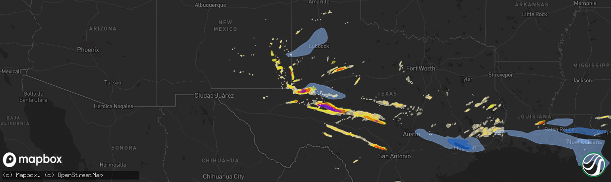
Hail Map on May 16, 2024
The weather event on May 16, 2024 includes Hail, Wind, and Tornado maps. 11 states and 588 cities were impacted and suffered possible damage. The total estimated number of properties impacted is 142,344.
Hail
Wind
Tornado
142,344
Estimated number of impacted properties by a 1.00" hail or larger52,454
Estimated number of impacted properties by a 1.75" hail or larger6,796
Estimated number of impacted properties by a 2.50" hail or largerStates Impacted by Hail Map on May 16, 2024
Storm reports
Alabama
| Date | Description |
|---|---|
| 05/16/20242:35 AM CDT | Weatherflow station |
| 05/16/20242:06 AM CDT | Ft gaines nos/coops site measured a marine wind gust of 58 mph. |
Florida
| Date | Description |
|---|---|
| 05/16/202412:45 PM CDT | Several downed trees and powerlines across immokalee. Tree down at 59th and palmetto ave blocking entire roadway. |
| 05/16/202412:45 PM CDT | Pictures on social media of damage left behind after strong thunderstorm. Medium-large tree limbs broken... Power line poles down... Tents blown over. |
| 05/16/202412:45 PM CDT | Corrects previous tstm wnd dmg report from 1 ene immokalee. Several downed trees and powerlines across immokalee. Tree down at south 9th and palmetto ave blocking entir |
| 05/16/20245:25 AM CDT | Franklin eoc weatherstem gusted to 60 mph along the coast. |
| 05/16/20245:25 AM CDT | A local report indicates 70 MPH wind near Apalachicola Airport |
| 05/16/20245:15 AM CDT | Porch screens ripped apart... Doors mechanisms torn... Dead trees broken... Light debris scattered. |
| 05/16/20245:13 AM CDT | Ambient station gusted to 74 mph. |
| 05/16/20245:07 AM CDT | Ambient station gusted to 62 mph. |
| 05/16/20245:06 AM CDT | Downed cable lines in port st. Joe. |
| 05/16/20245:02 AM CDT | Ambient station gusted to 87 mph. |
| 05/16/20245:01 AM CDT | Ambient station gusted to 71 mph. |
Louisiana
| Date | Description |
|---|---|
| 05/16/20246:57 PM CDT | Report of a tree down along hwy 26 south of oberlin. |
| 05/16/20246:53 PM CDT | Photo of numerous power poles snapped off on hwy 165 from storms south of oakdale. Time estimated by radar. |
| 05/16/20246:10 PM CDT | Utility company reports numerous power outages across beauregard parish. Trees down on power lines and power poles blown down. |
| 05/16/20245:55 PM CDT | Powerlines and power poles blown down along portions of hwy 171 south of deridder. Time estimated from radar. |
| 05/16/202412:06 AM CDT | Bayou bienvenue |
| 05/16/202412:01 AM CDT | New orleans lakefront airport recorded a second wind gust of 82 mph. |
| 05/16/202412:00 AM CDT | Nofd engine 36 - new orleans east la us weatherstem measured a wind gust of 62 mph. |
| 05/16/202412:00 AM CDT | Tree reported across i-59 near pearl river. |
| 05/15/202411:53 PM CDT | New orleans lakefront airport measured a wind gust of 82 mph. |
| 05/15/202411:45 PM CDT | Tree blown down on a fence in river ridge. |
| 05/15/202411:38 PM CDT | People trapped in overturned vehicle on france rd. |
| 05/15/202411:36 PM CDT | Msy asos measured a wind gust of 73.2 knots |
| 05/15/202411:35 PM CDT | A few trees and large limbs down. |
| 05/15/202411:34 PM CDT | Multiple trees down across covington with a few blocking side streets. Widespread power outages across the city. |
| 05/15/202410:51 PM CDT | Multiple reports of trees and power poles down. Cc drop detected on radar as well. |
| 05/15/202410:51 PM CDT | Trees down and some minor structural damage. |
| 05/15/202410:46 PM CDT | Nws storm survey team determined an ef-1 tornado... With a peak wind of 105 mph and a maximum width of 120 yards... Impacted romeville in st. James parish. This tornado |
| 05/15/202410:23 PM CDT | Report from mping: 1-inch tree limbs broken; shingles blown off. |
| 05/15/202410:21 PM CDT | Snapped power pole off of arnold road in denham springs... La. |
| 05/15/202410:21 PM CDT | Numerous downed trees in bayou sorrel near the hwy 75 bridge. Time estimated from radar. |
| 05/15/202410:10 PM CDT | Report from mping: 3-inch tree limbs broken; power poles broken. |
| 05/15/202410:10 PM CDT | Mesonet station 1311w lsu tiger stadium. |
| 05/15/202410:07 PM CDT | Em reported numerous trees down throughout the east side of st. Landry parish. High winds reports in melville area along with numerous power outages. |
| 05/15/202410:04 PM CDT | Local em reports 3 homes with damage from downed trees. Time estimated by radar. |
| 05/15/202410:04 PM CDT | Public reports numerous trees and power lines down around the catahoula community. Time estimated by radar. |
| 05/15/202410:00 PM CDT | Public reports numerous trees blown down between breaux bridge and parks. |
| 05/15/202410:00 PM CDT | Public reports damage to a residence. Corner of a roof was lifted up with the storm passage. Time estimated by radar. |
| 05/15/20249:58 PM CDT | Public reports roof blown off of home in st. Martinville. Time estimated by radar. |
| 05/15/20249:57 PM CDT | Report from mping: 1-inch tree limbs broken; shingles blown off. |
| 05/15/20249:57 PM CDT | Tree down on whitehaven. |
| 05/15/20249:56 PM CDT | Poles blown over along highland rd and e polk. |
| 05/15/20249:56 PM CDT | Tree down on a house off of plan rd and n. Acadian thwy. |
| 05/15/20249:55 PM CDT | Public reports residential window sucked out of its frame as the storm passed. Time estimated from radar. |
| 05/15/20249:49 PM CDT | Asos station klft lafayette. |
| 05/15/20249:47 PM CDT | Trees down in baker. Relayed via social media. |
| 05/15/20249:46 PM CDT | Awos station kara 4 sse cade. |
| 05/15/20249:41 PM CDT | Public photo of downed trees blocking the road. Time estimated by radar. |
| 05/15/20249:39 PM CDT | Report from mping: 1-inch tree limbs broken; shingles blown off. |
| 05/15/20249:39 PM CDT | Corrects previous flash flood report from 2 nnw carencro. Off duty nws employee reports multiple large tree branches down near carencro. |
| 05/15/20249:37 PM CDT | Multiple trees down and blocking some roads around slaughter. |
| 05/15/20249:36 PM CDT | Public submitted photo of power poles snapped with lines and transformers attached. Time estimated by radar. |
| 05/15/20249:34 PM CDT | Call from the public about strong wind gust measured on a personal weather station. |
| 05/15/20249:33 PM CDT | Photo received of a tree snapped off in lafayette. |
| 05/15/20249:32 PM CDT | Report of tree down in the parking lot of raising canes restaurant. Time estimated by radar. |
| 05/15/20249:31 PM CDT | Video received of large tree down on lyman ave in rayne. Time from radar. |
| 05/15/20249:30 PM CDT | Media posted a video of estimated 70 mph wind gust. Time estimated by radar. |
| 05/15/20249:30 PM CDT | Corrects previous tstm wnd dmg report from 1 wnw scott. Public submitted a photo of an uprooted tree falling on and partially crushing a small home on st mary st. |
| 05/15/20249:30 PM CDT | Branches down. |
| 05/15/20249:30 PM CDT | Large tree snapped. |
| 05/15/20249:30 PM CDT | Numerous trees snapped and uprooted. Damage indicators estimate wind gusts of 65 to 80 mph. |
| 05/15/20249:30 PM CDT | Large tree snapped across roadway. |
| 05/15/20249:29 PM CDT | Personal weather station reported a gust to 61 mph with storm passage. |
| 05/15/20249:28 PM CDT | Numerous branches snapped near ossun. |
| 05/15/20249:28 PM CDT | Numerous branches snapped... Some trees snapped and uprooted. |
| 05/15/20249:24 PM CDT | Numerous large branches snapped near vatican. |
| 05/15/20249:15 PM CDT | Awos station khzr new roads. |
| 05/15/20249:15 PM CDT | Mesonet station lsu03 crowley. |
| 05/15/20249:15 PM CDT | Public reports large oak limb was blown down onto power lines. |
| 05/15/20249:06 PM CDT | Utility company reports damage to the transmission lines service substations for elizabeth... Pitkin and sugartown. |
| 05/15/20248:02 PM CDT | Report of tree down on perkins ferry rd just north of joe miller rd. Time estimated by radar. |
| 05/15/20247:52 PM CDT | Photo of large oak tree blown down on front street in de quincy. Time estimated from radar. |
| 05/15/20247:52 PM CDT | Tree fell on reneau rd northeast of de quincy. Time estimated from radar. |
| 05/15/20247:33 PM CDT | Photo of large tree down in bayou chicot. Time estimated by radar when a hail core was descending out of storm. |
| 05/15/20247:22 PM CDT | Public report of trees down along hwy 109 near the starks community. |
| 05/15/20247:20 PM CDT | Numerous power outages reported north of starks near smith cemetery rd due to downed powerlines. |
| 05/15/20247:12 PM CDT | Power outages reported near old river rd due to downed power lines. |
Texas
| Date | Description |
|---|---|
| 05/16/20246:59 PM CDT | Report of tree down on the southbound land of hwy 62 near the new cherry grove baptist church. Time estimated from radar. |
| 05/16/20246:57 PM CDT | Report from mping: half dollar |
| 05/16/20246:57 PM CDT | Power pole snapped off by the storm was replaced in downtown buna. Time estimated by radar. |
| 05/16/20246:56 PM CDT | Report of tree down on fm 363 and lewis chapel. Time estimated from radar. |
| 05/16/20246:55 PM CDT | Awos station kmcj houston univ. |
| 05/16/20246:54 PM CDT | Mesonet station ptkt2 650 patricks bayou at east 8th s. |
| 05/16/20246:54 PM CDT | Mesonet station 55 5sw st. Lawrence... Tx. |
| 05/16/20246:52 PM CDT | A local report indicates 1.00 inch wind near 4 SW Christoval |
| 05/16/20246:52 PM CDT | Mesonet station ur098 3.3 nw greenwood |
| 05/16/20246:51 PM CDT | Numerous power poles and trees knocked down or snapped off. |
| 05/16/20246:48 PM CDT | Small shed blown away and dumpster tipped over. |
| 05/16/20246:45 PM CDT | Multiple areas of wind damage including billboards blown apart and a radio tower collapsed along bus 20. |
| 05/16/20246:45 PM CDT | Asos station kiah houston intnl. |
| 05/16/20246:43 PM CDT | A local report indicates 1.00 inch wind near 15 NNW Eldorado |
| 05/16/20246:43 PM CDT | Numerous windows blown out downtown skyscrapers. |
| 05/16/20246:43 PM CDT | Photo of tree blown down on a powerline south of evadale. Time estimated from radar. |
| 05/16/20246:41 PM CDT | Widespread trees downed across the area. Homes damaged throughout the neighborhood. |
| 05/16/20246:39 PM CDT | Multiple trees down. Denver harbor area. |
| 05/16/20246:35 PM CDT | Rosas cafe sign blown apart. |
| 05/16/20246:35 PM CDT | Awos station kmdd midland airpark. |
| 05/16/20246:30 PM CDT | Awos station kpvw hale county airport. |
| 05/16/20246:30 PM CDT | Large trees down i45 & parker rd. |
| 05/16/20246:30 PM CDT | *** 4 fatal *** 4 confirmed fatalities and 1 unconfirmed fatality across different locations across the houston metro area from fallen trees and a crane incident. |
| 05/16/20246:28 PM CDT | Asos station kmaf midland. |
| 05/16/20246:27 PM CDT | West texas mesonet. |
| 05/16/20246:26 PM CDT | Asos station kodo odessa. |
| 05/16/20246:25 PM CDT | Large tree uprooted and street light taken down by high winds. |
| 05/16/20246:23 PM CDT | Large tree uprooted near sherwood park. |
| 05/16/20246:20 PM CDT | Storm chaser sent a photo of a gas station canopy destroyed. |
| 05/16/20246:17 PM CDT | A local report indicates 1.00 inch wind near Crane |
| 05/16/20246:15 PM CDT | Photo showing approximately half dollar size hail. |
| 05/16/20246:15 PM CDT | Mesonet station cw9236 cypress. |
| 05/16/20246:15 PM CDT | Multiple trees down. |
| 05/16/20246:15 PM CDT | Mesonet station fw9685 odessa. |
| 05/16/20246:14 PM CDT | A local report indicates 1.50 inch wind near 11 WSW Mertzon |
| 05/16/20246:12 PM CDT | Hail ranged from half inch to quarter size at sh191 and avalon. |
| 05/16/20246:10 PM CDT | Transmission lines down. |
| 05/16/20246:10 PM CDT | Corrects previous flash flood report from 6 wnw honey island. Ham reports large tree down across fm 1293 in honey island. Time estimated by radar. |
| 05/16/20246:08 PM CDT | Tornado touched down near intersection of tuckerton and greenhouse roads then tracked southeastward through highlands subdivision. Numerous single family homes had roof |
| 05/16/20246:05 PM CDT | A local report indicates 2.75 inch wind near 6 N Barnhart |
| 05/16/20246:03 PM CDT | Asos station klbb lubbock intl airport. |
| 05/16/20246:02 PM CDT | Numerous power outages resulting from downed powerlines from trees. Time estimated by radar. |
| 05/16/20246:00 PM CDT | Mesonet station fw9693 pyote. |
| 05/16/20246:00 PM CDT | Trees downed. |
| 05/16/20246:00 PM CDT | Roof damage kermier rd and pine tree lane. Debris multiple directions. |
| 05/16/20245:58 PM CDT | Mesonet station 030hc 4650 hwy 6 at sh290. |
| 05/16/20245:57 PM CDT | Report from mping: quarter |
| 05/16/20245:56 PM CDT | West texas mesonet. |
| 05/16/20245:55 PM CDT | Roof damage to newly built home. |
| 05/16/20245:53 PM CDT | Asos station kink wink. |
| 05/16/20245:51 PM CDT | Estimated 60 to 70 mph wind gusts at billy hext and sh 191. |
| 05/16/20245:50 PM CDT | Golf ball sized hail observed at university and grandview in odessa. |
| 05/16/20245:50 PM CDT | Mesonet station 1757w texas a&m kyle field. |
| 05/16/20245:45 PM CDT | Trees down. |
| 05/16/20245:45 PM CDT | Trees down. Social media. |
| 05/16/20245:44 PM CDT | Large metal barn destroyed... Trailers rolled. Metal debris strewn 1000 yards to se. Tree fall in multiple directions ranging from s to nw. |
| 05/16/20245:42 PM CDT | Time estimated by radar. |
| 05/16/20245:39 PM CDT | Multiple observations of quarter sized hail in west odessa. |
| 05/16/20245:30 PM CDT | Trees down... Metal roofs blown off. |
| 05/16/20245:29 PM CDT | Report from mping 3-inch tree limbs broken; power poles broken. |
| 05/16/20245:23 PM CDT | Report from mping 1-inch tree limbs broken; shingles blown off. |
| 05/16/20245:19 PM CDT | Seminole fire department reported power lines down at cr316 and cr327. |
| 05/16/20245:15 PM CDT | Numerous reports of wind damage in addition to power outages in fayette county... Including the city of la grange. |
| 05/16/20245:15 PM CDT | Photo shared of a collapsed radio tower near notrees. Time is estimated from radar. Wind speeds are estimated to have been approximately 110-120 mph. |
| 05/16/20245:13 PM CDT | A local report indicates 61 MPH wind near 6 NNW Levelland |
| 05/16/20245:13 PM CDT | Jasper county 911 reports multiple power outages and power lines down across the county with the storms passage. |
| 05/16/20245:10 PM CDT | Trees down. Funnel cloud sighted... Possible tornado. Near wesley. |
| 05/16/20245:00 PM CDT | Report from mping trees uprooted or snapped; roof blown off. |
| 05/16/20245:00 PM CDT | Public photo shared of half dollar size hail. |
| 05/16/20244:57 PM CDT | Damage to a barn as well as a flipped rv near winedale off fm 2714. |
| 05/16/20244:55 PM CDT | 3 inch diameter hail measured... Photo via twitter/x. |
| 05/16/20244:55 PM CDT | Report from mping 3-inch tree limbs broken; power poles broken. |
| 05/16/20244:45 PM CDT | Report relayed via the public from nws hgx of wind damage and numerous trees limbs down along highway 21 and private rd 80 northwest of giddings. |
| 05/16/20244:45 PM CDT | Trees down on roadways. |
| 05/16/20244:45 PM CDT | Delayed social media report of downed trees... Several large tree limbs... And minor cosmetic damage within the town of warda. |
| 05/16/20244:35 PM CDT | West texas mesonet. Also gusted to 59 mph from 4:36 to 4:37 pm. |
| 05/16/20244:31 PM CDT | Large tree down over the road at mcneil and parmer in north austin. |
| 05/16/20244:27 PM CDT | Large tree down in north austin via slack. |
| 05/16/20244:26 PM CDT | Tyler county 911 reported powerlines down and power outages occurred across the county with the storms passage. |
| 05/16/20244:24 PM CDT | County dispatch reported 1 inch hail over diamond lil strip. |
| 05/16/20244:20 PM CDT | Damage to a carport... Tossed and mangled and partially removed roof damage to a barn in west bastrop. Time approximated via radar. |
| 05/16/20244:15 PM CDT | 6+ inch diameter tree snapped in circle c neighborhood in south austin. |
| 05/16/20244:15 PM CDT | Fallen trees and home damage reported along wolf run road. |
| 05/16/20243:30 PM CDT | [landspout] video relayed by media. |
| 05/16/20242:40 PM CDT | Numerous power outages in milam... Tx. |
| 05/16/20242:31 PM CDT | A picture was posted to social media of quarter size hail that fell near broaddus. |
| 05/16/20241:21 PM CDT | Observed on live-streaming webcam. Mostly dime to nickel size with a few quarter size stones. |
| 05/16/20241:21 PM CDT | Observed on |
| 05/16/202412:43 PM CDT | A local report indicates 1.75 inch wind near Snyder |
| 05/16/202412:40 PM CDT | Report from mping: quarter |
| 05/16/202412:00 AM CDT | Picture of half dollar sized hail. |
| 05/15/202411:45 PM CDT | 2 minutes of hail with max size of golfballs. |
| 05/15/202410:01 PM CDT | Report from mping: 3-inch tree limbs broken; power poles broken. |
| 05/15/20248:50 PM CDT | Golf ball and larger hail across mason. |
| 05/15/20248:18 PM CDT | A local report indicates 1.50 inch wind near 4 W Hext |
| 05/15/20248:02 PM CDT | Report from mping: half dollar |
| 05/15/20248:01 PM CDT | Coop observer reported quarter size hail and 50 mph winds just south of the menard airport at 8:01 pm. |
| 05/15/20248:00 PM CDT | Measured gust to 81 mph by the menard west texas mesonet station. |
| 05/15/20247:45 PM CDT | Tin roof blown off a structure along highway 158 northeast of sterling city. |
| 05/15/20247:40 PM CDT | Estimated 70+ mph winds at sterling city. |
| 05/15/20247:34 PM CDT | Fire department working power lines down between kountze and silsbee. |
| 05/15/20247:25 PM CDT | Tree limbs down. |
| 05/15/20247:25 PM CDT | Fire dept working an area of downed power lines southwest of silsbee. |
| 05/15/20247:20 PM CDT | Numerous power outages resulting from downed power lines and trees. Time estimated by radar. |
| 05/15/20247:15 PM CDT | Mesonet station 9221d morgan's point. |
| 05/15/20247:15 PM CDT | Mesonet station cbht2 1710 cedar bayou at sh 99. |
| 05/15/20247:11 PM CDT | Report from mping: trees uprooted or snapped; roof blown off. |
| 05/15/20247:10 PM CDT | Large trees blow down across fm 770 about 1 mile west of saratoga tx. Several power lines down in the same area as well. |
| 05/15/20247:07 PM CDT | Wind blew back part of roof at chambers county ems in cove. Time estimated by radar. |
| 05/15/20247:05 PM CDT | Multiple ships along the upper houston ship channel have either broken away or are currently being supported by tugs. A pollution incident is reported at kavavnaugh doc |
| 05/15/20247:03 PM CDT | Mesonet station mndt2 midland. |
| 05/15/20247:02 PM CDT | Mesonet station scpt2 2200 houston ship channel at jua. |
| 05/15/20247:01 PM CDT | Mesonet station hlnt2 g103 san jacinto river at i-10 e. |
| 05/15/20247:00 PM CDT | Numerous trees and power lines down. |
| 05/15/20247:00 PM CDT | Report from mping: 1-inch tree limbs broken; shingles blown off. |
| 05/15/20247:00 PM CDT | Asos station khou houston hobby. |
| 05/15/20247:00 PM CDT | Public video of siding damage to cougar stop in buna... Tx. Time estimated by radar. |
| 05/15/20247:00 PM CDT | Corrects previous hail report from 1 s buna. Public photo of quarter size hail in buna. Time estimated by radar. |
Mississippi
| Date | Description |
|---|---|
| 05/16/202412:20 AM CDT | Fascia damage to building and roof damage to open pole barn. Time estimated by radar. |
North Dakota
| Date | Description |
|---|---|
| 05/15/20249:40 PM CDT | Delayed report from social media... Time estimated from radar. |
| 05/15/20249:15 PM CDT | 1 inch hail reported 2 miles north of luverne nd. |
Montana
| Date | Description |
|---|---|
| 05/16/20245:15 PM CDT | [landspout] corrects previous landspout report from 18 ne whitewater. |
| 05/16/20245:12 PM CDT | [landspout] |
South Dakota
| Date | Description |
|---|---|
| 05/15/20247:50 PM CDT | Pea sized hail |
Cities Impacted by Hail Map on May 16, 2024
- Graford, TX
- Perrin, TX
- Mineral Wells, TX
- Palo Pinto, TX
- Santo, TX
- Millsap, TX
- Tolar, TX
- Granbury, TX
- Bluff Dale, TX
- Glen Rose, TX
- Rainbow, TX
- Nemo, TX
- Kopperl, TX
- Blackwell, TX
- Tatum, NM
- Ballinger, TX
- Ozona, TX
- Rowena, TX
- Paint Rock, TX
- Millersview, TX
- Tuscola, TX
- Voss, TX
- Merkel, TX
- Eldorado, TX
- Gouldbusk, TX
- Elida, NM
- Abilene, TX
- Rockwood, TX
- Santa Anna, TX
- Coleman, TX
- Alto, NM
- Nogal, NM
- Rochelle, TX
- Brookesmith, TX
- Pep, NM
- West, TX
- Fairfield, TX
- Brownwood, TX
- Elm Mott, TX
- Waco, TX
- Mullin, TX
- Richland Springs, TX
- Axtell, TX
- Mount Calm, TX
- Trent, TX
- Muleshoe, TX
- Christoval, TX
- Goldthwaite, TX
- Prairie Hill, TX
- Mart, TX
- Coahoma, TX
- Ira, TX
- San Saba, TX
- Lenorah, TX
- Knott, TX
- Snyder, TX
- Menard, TX
- Immokalee, FL
- Big Spring, TX
- Gail, TX
- Eden, TX
- Tinnie, NM
- Lometa, TX
- Star, TX
- Lampasas, TX
- Weed, NM
- Pinon, NM
- Hermleigh, TX
- Copperas Cove, TX
- Gatesville, TX
- Stamford, TX
- Evant, TX
- Rotan, TX
- Nacogdoches, TX
- Fluvanna, TX
- Sweetwater, TX
- Hext, TX
- Chireno, TX
- Justiceburg, TX
- Bent, NM
- Roswell, NM
- Fort Hood, TX
- San Augustine, TX
- Center, TX
- Grapeland, TX
- Kennard, TX
- Hamlin, TX
- Roby, TX
- Rusk, TX
- Fort Sumner, NM
- Crockett, TX
- Sudan, TX
- Mason, TX
- McCaulley, TX
- Temple, TX
- Lufkin, TX
- Brady, TX
- Moody, TX
- Theriot, LA
- Alto, TX
- Wells, TX
- Kempner, TX
- Pollok, TX
- Troy, TX
- Post, TX
- Fredonia, TX
- Huntington, TX
- Broaddus, TX
- Killeen, TX
- Zavalla, TX
- Lovelady, TX
- Hagerman, NM
- Seminole, TX
- Bronson, TX
- Pennington, TX
- Groveton, TX
- Tow, TX
- Maljamar, NM
- Pineland, TX
- Lovington, NM
- Hemphill, TX
- Harker Heights, TX
- Nolan, TX
- Denver City, TX
- Belton, TX
- Andrews, TX
- Burnet, TX
- Calico Rock, AR
- Salt Flat, TX
- Caldwell, TX
- Anderson, TX
- Jefferson, WI
- Helenville, WI
- Jal, NM
- Hobbs, NM
- Deridder, LA
- Pitkin, LA
- Sugartown, LA
- Eunice, NM
- College Station, TX
- Bedias, TX
- Plains, TX
- Goodrich, TX
- Shepherd, TX
- Livingston, TX
- Huntsville, TX
- Kirbyville, TX
- Jasper, TX
- Newton, TX
- Iola, TX
- Richards, TX
- Colmesneil, TX
- Kermit, TX
- Midkiff, TX
- Lincoln, TX
- Giddings, TX
- Barstow, TX
- Dry Creek, LA
- Coldspring, TX
- Woodville, TX
- Big Lake, TX
- Monahans, TX
- Cleveland, TX
- New Caney, TX
- Splendora, TX
- Brackettville, TX
- Ville Platte, LA
- Opelousas, LA
- Washington, LA
- Bon Wier, TX
- Conroe, TX
- Dime Box, TX
- Grandfalls, TX
- Warren, TX
- Bunkie, LA
- Uvalde, TX
- Ledbetter, TX
- Dayton, TX
- Palmetto, LA
- Plaucheville, LA
- Melville, LA
- Notrees, TX
- Goldsmith, TX
- Seagraves, TX
- Dimmitt, TX
- Whitewater, MT
- Morganza, LA
- Batchelor, LA
- Merryville, LA
- Burkeville, TX
- New Roads, LA
- Brenham, TX
- Chappell Hill, TX
- Odessa, TX
- Barnhart, TX
- Mertzon, TX
- Hempstead, TX
- Washington, TX
- Navasota, TX
- Nazareth, TX
- Saratoga, TX
- Gardendale, TX
- Bellville, TX
- Brookshire, TX
- Sealy, TX
- Prairie View, TX
- Waller, TX
- Katy, TX
- Hockley, TX
- Cypress, TX
- Tomball, TX
- Magnolia, TX
- Tokio, TX
- Brownfield, TX
- Morton, TX
- Sundown, TX
- Meadow, TX
- Whiteface, TX
- Levelland, TX
- Littlefield, TX
- Wolfforth, TX
- Smyer, TX
- Ropesville, TX
- Lubbock, TX
- Shallowater, TX
- Anton, TX
- Singer, LA
- Kountze, TX
- Saint Martinville, LA
- Grosse Tete, LA
- Midland, TX
- Houston, TX
- Crane, TX
- Tulia, TX
- Longville, LA
- Sour Lake, TX
- Batson, TX
- Idalou, TX
- Abernathy, TX
- Petersburg, TX
- New Deal, TX
- Stanton, TX
- Spring, TX
- Mittie, LA
- Silsbee, TX
- Liberty, TX
- Port Allen, LA
- Brusly, LA
- Addis, LA
- Grant, LA
- McCamey, TX
- Lorenzo, TX
- Oberlin, LA
- Kinder, LA
- Hull, TX
- Buna, TX
- Fred, TX
- Baker, LA
- Baton Rouge, LA
- Reeves, LA
- Vida, MT
- Lumberton, TX
- Richmond, TX
- Rosenberg, TX
- Wallis, TX
- Oakdale, LA
- Humble, TX
- Elizabeth, LA
- South Houston, TX
- Bellaire, TX
- Pasadena, TX
- Galena Park, TX
- Deer Park, TX
- Channelview, TX
- Highlands, TX
- Hale Center, TX
- Plainview, TX
- Garden City, TX
- San Angelo, TX
- Mamou, LA
- Opheim, MT
- Seabrook, TX
- Baytown, TX
- La Porte, TX
- Webster, TX
- Crosby, TX
- Floydada, TX
- Lockney, TX
- Ralls, TX
- Kemah, TX
- League City, TX
- Anahuac, TX
- Wallisville, TX
- Wayside, TX
- Happy, TX
- Pearland, TX
- Fresno, TX
- Rankin, TX
- Claude, TX
- Jackson, LA
- Kaukauna, WI
- Kyle, SD
- Mchenry, ND
- Vidor, TX
- Seymour, WI
- De Pere, WI
- Call, TX
- Basile, LA
- Elton, LA
- Deweyville, TX
- Sterling City, TX
- Winnie, TX
- Vancourt, TX
- Starks, LA
- Richland, MT
- Eunice, LA
- Pearlington, MS
- Bay Saint Louis, MS
- Orange, TX
- Pinehurst, TX
- Kingwood, TX
- Porter, TX
- Huffman, TX
- Hankamer, TX
- Bleiblerville, TX
- Cat Spring, TX
- New Ulm, TX
- Vinton, LA
- Dequincy, LA
- Sulphur, LA
- Fulshear, TX
- Waveland, MS
- Burton, TX
- Industry, TX
- Fayetteville, TX
- Round Top, TX
- Paige, TX
- Carmine, TX
- Lexington, TX
- La Grange, TX
- Smithville, TX
- Bastrop, TX
- McDade, TX
- Manor, TX
- Elgin, TX
- Coupland, TX
- Taylor, TX
- Thrall, TX
- Binford, ND
- Porcupine, SD
- Allen, SD
- Wanblee, SD
- New Rockford, ND
- Glenfield, ND
- Cameron, LA
- Lake Charles, LA
- Ragley, LA
- Cooperstown, ND
- Port Arthur, TX
- Melvin, TX
- Pine Ridge, SD
- Carlsbad, TX
- Robert Lee, TX
- Hannaford, ND
- Bell City, LA
- Martin, SD
- Hackberry, LA
- Art, TX
- Castell, TX
- Iota, LA
- Jennings, LA
- Evangeline, LA
- Comstock, TX
- Voca, TX
- Fordoche, LA
- Port Barre, LA
- Krotz Springs, LA
- Saint Francisville, LA
- Roanoke, LA
- Childress, TX
- Luverne, ND
- Morse, LA
- Mermentau, LA
- Egan, LA
- Llano, TX
- Grand Chenier, LA
- Kaplan, LA
- Gueydan, LA
- Pontotoc, TX
- Valley Spring, TX
- Hope, ND
- Sonora, TX
- Dazey, ND
- Livonia, LA
- Lottie, LA
- Maringouin, LA
- Jarreau, LA
- Oscar, LA
- Lakeland, LA
- Rayne, LA
- Creole, LA
- Maurice, LA
- Duson, LA
- Rougon, LA
- Ventress, LA
- Glynn, LA
- Erwinville, LA
- Zachary, LA
- Slaughter, LA
- Ethel, LA
- Pillsbury, ND
- Bluffton, TX
- Abbeville, LA
- Rocksprings, TX
- Lafayette, LA
- Youngsville, LA
- Page, ND
- Lake Arthur, LA
- Welsh, LA
- Church Point, LA
- Branch, LA
- Crowley, LA
- Estherwood, LA
- Carencro, LA
- Sunset, LA
- Arnaudville, LA
- Scott, LA
- New Iberia, LA
- Delcambre, LA
- Broussard, LA
- Erath, LA
- Breaux Bridge, LA
- Loreauville, LA
- Jeanerette, LA
- Greensburg, LA
- Pride, LA
- Clinton, LA
- Greenwell Springs, LA
- Denham Springs, LA
- Buchanan Dam, TX
- Kentwood, LA
- Walker, LA
- Pine Grove, LA
- Amite, LA
- Holden, LA
- Plaquemine, LA
- Rosedale, LA
- Sunshine, LA
- Franklin, LA
- Baldwin, LA
- Pierre Part, LA
- Morgan City, LA
- White Castle, LA
- Gonzales, LA
- Darrow, LA
- Sorrento, LA
- Belle Rose, LA
- Corsicana, TX
- Weatherford, TX
- Purdon, TX
- Richland, TX
- Geismar, LA
- Donaldsonville, LA
- Salado, TX
- Napoleonville, LA
- Streetman, TX
- Roseland, LA
- Independence, LA
- Livingston, LA
- Plattenville, LA
- Saint Gabriel, LA
- Carville, LA
- Convent, LA
- Paulina, LA
- Leakey, TX
- Saint James, LA
- Tickfaw, LA
- Hammond, LA
- Ponchatoula, LA
- Hunt, TX
- Loranger, LA
- Vanderpool, TX
- Ama, LA
- Medina, TX
- New Orleans, LA
- Westwego, LA
- Marrero, LA
- Kenner, LA
- Metairie, LA
- Prairieville, LA
- French Settlement, LA
- Albany, LA
- Springfield, LA
- Abita Springs, LA
- Robert, LA
- Madisonville, LA
- Covington, LA
- Mandeville, LA
- Lacombe, LA
- Bandera, TX
- Pipe Creek, TX
- Barataria, LA
- Lafitte, LA
- Cut Off, LA
- Lockport, LA
- Edgard, LA
- Raceland, LA
- Lutcher, LA
- Des Allemands, LA
- Hahnville, LA
- Thibodaux, LA
- Vacherie, LA
- Gray, LA
- Labadieville, LA
- Houma, LA
- Schriever, LA
- Mathews, LA
- Gheens, LA
- Boutte, LA
- Luling, LA
- Reserve, LA
- Destrehan, LA
- Saint Amant, LA
- La Place, LA
- Saint Rose, LA
- Garyville, LA
- Gramercy, LA
- Mount Airy, LA
- Paradis, LA
- Norco, LA
- Maurepas, LA
- Helotes, TX
- Arabi, LA
- Port Sulphur, LA
- Belle Chasse, LA
- Violet, LA
- Gretna, LA
- Meraux, LA
- Chalmette, LA
- Saint Bernard, LA
- Braithwaite, LA
- Harvey, LA
- Berwick, LA
- Patterson, LA
- Pearl River, LA
- Slidell, LA
- Gulfport, MS
- Long Beach, MS
- Stennis Space Center, MS
- Pass Christian, MS
- Picayune, MS
- Kiln, MS
- Diamondhead, MS
- Lumberton, MS
- Wiggins, MS
- Poplarville, MS
- Brooklyn, MS
- Eagle Pass, TX
- Laredo, TX
- Lucedale, MS
- Cotulla, TX
- Chunchula, AL
- Axis, AL
- Encinal, TX
- Wilmer, AL
- Citronelle, AL
- Calliham, TX
- Creola, AL
- Saraland, AL
- Tilden, TX
- Saucier, MS
- Three Rivers, TX
- Bay Minette, AL
- McLain, MS
- George West, TX
- Lacassine, LA
- Westlake, LA
- Iowa, LA
- Golden Meadow, LA
- Galliano, LA
- Larose, LA
- Grand Isle, LA
- Buras, LA
- Venice, LA
- Port Saint Joe, FL
- Eastpoint, FL
- Apalachicola, FL
- Wewahitchka, FL