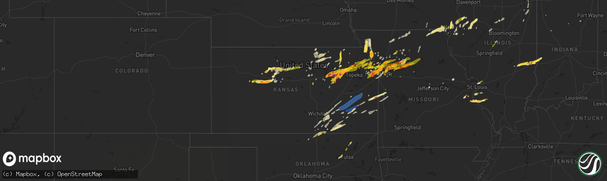
Hail Map in Kansas on March 13, 2024
The weather event in Kansas on March 13, 2024 includes Hail, Wind, and Tornado maps. 6 states and 484 cities were impacted and suffered possible damage. The total estimated number of properties impacted is 127,734.
Hail
Wind
Tornado
127,734
Estimated number of impacted properties by a 1.00" hail or larger57,671
Estimated number of impacted properties by a 1.75" hail or larger45,089
Estimated number of impacted properties by a 2.50" hail or largerStorm reports in Kansas
Kansas
| Date | Description |
|---|---|
| 03/13/20246:55 PM CDT | Public report of hail up to golf ball size one mile in from very southwest corner of rooks county. Time estimated from radar. |
| 03/13/20242:00 AM CDT | Personal weather station. |
| 03/13/20241:20 AM CDT | A local report indicates 61 MPH wind near Lillis |
| 03/13/20241:19 AM CDT | Measured at eureka municipal airport. |
| 03/12/202411:46 PM CDT | Emergency manager reports up to quarter size hail covering the ground on k-92 near 195th street. Time based on dispatch report and confirmed by radar. |
| 03/12/202411:38 PM CDT | Social media report of up to quarter size hail in fort leavenworth. Time estimated from radar. |
| 03/12/202411:30 PM CDT | Public estimated 60 mph wind gusts just north of minneapolis on highway 81. Called into dispatch. |
| 03/12/202410:57 PM CDT | Quarter size hail reported in springdale. Time estimated from radar. |
| 03/12/202410:12 PM CDT | Report from mping: quarter |
| 03/12/202410:12 PM CDT | Report from mpi |
| 03/12/202410:08 PM CDT | A local report indicates 1.00 inch wind near 3 NE Valley Falls |
| 03/12/20249:45 PM CDT | A local report indicates 1.00 inch wind near 13 SW Tipton |
| 03/12/20249:45 PM CDT | A local report indicates 2.00 inch wind near 2 N Paxico |
| 03/12/20249:42 PM CDT | Report via twitter. |
| 03/12/20249:42 PM CDT | Report via twitter. |
| 03/12/20249:32 PM CDT | Ground covered in quarter size hail in wamego reported by law enforcement relayed by em. |
| 03/12/20249:32 PM CDT | A local report indicates 1.00 inch wind near 4 NW Emmeram |
| 03/12/20249:30 PM CDT | A local report indicates 1.00 inch wind near 3 ENE Hoyt |
| 03/12/20249:30 PM CDT | Report was from social media. |
| 03/12/20249:29 PM CDT | Report from mping: quarter |
| 03/12/20249:22 PM CDT | Ping pong size hail reported by spotter. |
| 03/12/20249:21 PM CDT | Report from mping: quarter |
| 03/12/20249:21 PM CDT | A local report indicates 1.00 inch wind near 2 SSE Hays |
| 03/12/20249:20 PM CDT | Report was from social media. |
| 03/12/20249:20 PM CDT | Report was from social media. |
| 03/12/20249:20 PM CDT | Corrects previous hail report from 5 sse manhattan. Report from mping: hen egg |
| 03/12/20249:17 PM CDT | Quarter size hail reported by emergency management. |
| 03/12/20249:12 PM CDT | Report was from social media. |
| 03/12/20249:11 PM CDT | A local report indicates 1.50 inch wind near 6 NE Codell |
| 03/12/20249:11 PM CDT | Corrected location previous hail report from 6 ne codell. |
| 03/12/20249:10 PM CDT | On deep creek road south of manhattan. |
| 03/12/20249:03 PM CDT | Report from mping: golf ball |
| 03/12/20249:02 PM CDT | Delayed report. |
| 03/12/20249:00 PM CDT | Picture from facebook. |
| 03/12/20249:00 PM CDT | Report from mping: quarter |
| 03/12/20249:00 PM CDT | Report from mping: ping pong ball |
| 03/12/20248:56 PM CDT | Social media post and photo of approximately tennis ball size hail in wathena. Time estimated from radar. |
| 03/12/20248:50 PM CDT | Corrects previous hail report time and location previous hail report from 6 ne codell. |
| 03/12/20248:50 PM CDT | Hail fell at 99th and leavenworth road in kck. Public reported. |
| 03/12/20248:40 PM CDT | A local report indicates 1.75 inch wind near 5 E Cedar Bluff |
| 03/12/20248:39 PM CDT | A local report indicates 2.00 inch wind near 9 ESE Cedar Bluff |
| 03/12/20248:33 PM CDT | Public reports relayed by emergency management of a tornado on the ground at 62nd and valencia near rossvile. |
| 03/12/20248:30 PM CDT | Baseball size hail reported via emergency management. |
| 03/12/20248:30 PM CDT | Damage to cars and house shingles. |
| 03/12/20248:24 PM CDT | 2 inch hail at the grandview plaza exit on i-70. Time estimated from radar. |
| 03/12/20248:24 PM CDT | Report from mping: ping pong ball |
| 03/12/20248:23 PM CDT | Downed trees and wires near tenny avenue. Time estimated from radar. |
| 03/12/20248:21 PM CDT | Report from mping: ping pong ball |
| 03/12/20248:21 PM CDT | Report from mping: ping pong |
| 03/12/20248:20 PM CDT | Social media report of wind damage at a residence... Including to multiple fences and a porch. Large hail also damaged windows and door screens. Time and location estim |
| 03/12/20248:18 PM CDT | Report from mping: quarter |
| 03/12/20248:17 PM CDT | A local report indicates 1.50 inch wind near Grandview Plaza |
| 03/12/20248:15 PM CDT | Law enformcement reporting a tornado on the ground. |
| 03/12/20248:14 PM CDT | Photo of golf ball sized hail in kansas city... Ks. Time and location estimated from radar. |
| 03/12/20248:12 PM CDT | Quarter sized hail on johnson drive east of i-435. |
| 03/12/20248:12 PM CDT | A local report indicates 2.00 inch wind near 4 SW Cedar Bluff |
| 03/12/20248:10 PM CDT | Hail covering the ground and size at least a quarter sized. |
| 03/12/20248:10 PM CDT | 89th & anne ave.... Kck golf ball sized hail and heavy rain. |
| 03/12/20248:10 PM CDT | A local report indicates 1.00 inch wind near 3 SSW Cedar Bluff |
| 03/12/20248:10 PM CDT | Downed tree and wires near argentine boulevard. Time estimated from radar. |
| 03/12/20248:08 PM CDT | Softball size hail reported by law enforcement 2 wsw of alma. |
| 03/12/20248:07 PM CDT | Report from mping: half dollar |
| 03/12/20248:05 PM CDT | Broadcast media reports tennis ball sized hail in edwardsville. Time confirmed from radar. |
| 03/12/20248:05 PM CDT | Downed tree and wires near powell avenue. Time estimated from radar. |
| 03/12/20248:04 PM CDT | Report from mping: golf ball |
| 03/12/20248:04 PM CDT | Report from mping: golf ball . Time estimated from radar. Radar. |
| 03/12/20248:03 PM CDT | Ping pong ball sized hail near 99th street and leavenworth road. Time confirmed from radar. |
| 03/12/20248:03 PM CDT | A local report indicates 1.50 inch wind near 3 SW Junction City |
| 03/12/20248:02 PM CDT | A local report indicates 1.00 inch wind near Junction City |
| 03/12/20248:02 PM CDT | Report from mping: half dollar |
| 03/12/20248:02 PM CDT | Report from mping: quarter |
| 03/12/20248:02 PM CDT | Baseball sized hail damaged car windows. Time estimated from radar. |
| 03/12/20248:02 PM CDT | Delayed report: 1 rancher reported 5 barns damaged... But no damage to his residence. Time estimated from radar. |
| 03/12/20248:01 PM CDT | Quarter size hail at 99th and leavenworth road in kck. |
| 03/12/20248:00 PM CDT | Photo of approximately tennis ball sized hail near 64th and monticello. Time confirmed from radar. |
| 03/12/20248:00 PM CDT | Photo of two inch diameter hail near 64th and woodland. Time estimated from radar. |
| 03/12/20248:00 PM CDT | Two inch hail in mill valley with broken windshields. Time estimated from radar. |
| 03/12/20247:58 PM CDT | Severe storm damaged power lines and produced power outages south of maywood. Time estimated from radar. |
| 03/12/20247:57 PM CDT | Inch and a half sized hail reported at 167th/coffin road north of fort leavenworth... Ks |
| 03/12/20247:57 PM CDT | Photo of baseball sized hail in shawnee. Time estimated from radar. |
| 03/12/20247:57 PM CDT | Photo of two-inch diameter hail just west of edwardsville. Time estimated from radar. |
| 03/12/20247:55 PM CDT | Hail measured at 3.5 inches in diameter at 55th street and mccormick drive. Photo provided to trained spotter and relayed to the office. Time estimated from radar. |
| 03/12/20247:55 PM CDT | Photo of golf ball size hail just north of kansas speedway. Time estimated from radar. |
| 03/12/20247:54 PM CDT | Golf ball sized hail at the intersection of 64th street and monticello road. |
| 03/12/20247:54 PM CDT | Report from mping: baseball |
| 03/12/20247:52 PM CDT | Photo of golf ball sized hail in bonner springs. Time estimated from radar. |
| 03/12/20247:50 PM CDT | A local report indicates a tornado near 3 NE Alta Vista |
| 03/12/20247:50 PM CDT | Hail up to tennis ball size near 64th street and brockway street. Time estimated from radar. |
| 03/12/20247:50 PM CDT | A local report indicates 1.50 inch wind near 3 ESE Zurich |
| 03/12/20247:50 PM CDT | Photo of two-inch diameter hail near mill valley high school. Time estimated from radar. |
| 03/12/20247:46 PM CDT | A local report indicates 1.25 inch wind near 9 S Trego Center |
| 03/12/20247:45 PM CDT | Quarter sized hail near 158th street and loring rd. |
| 03/12/20247:40 PM CDT | Mping report of quarter sized hail. Time confirmed from radar. |
| 03/12/20247:38 PM CDT | Photo of approximately half dollar size hail in the western side of lenexa. Time estimated from radar. |
| 03/12/20247:36 PM CDT | Nickel to quarter sized hail at 166th street and golden road. |
| 03/12/20247:36 PM CDT | A local report indicates 1.00 inch wind near 6 SW Trego Center |
| 03/12/20247:34 PM CDT | Ping pong ball size hail reported in alma. |
| 03/12/20247:34 PM CDT | Ping pong ball size hail reported in alma. |
| 03/12/20247:30 PM CDT | A resident reported quarter sized hail in de soto. Time confirmed from radar. |
| 03/12/20247:30 PM CDT | Delayed report. 1.75 inch hail near the geary morris county line north of dwight. Time estimated from radar. |
| 03/12/20247:30 PM CDT | Delayed report. 1.75 inch hail near the geary morris county line north of dwight. Time estimated from radar. |
| 03/12/20247:22 PM CDT | A local report indicates 1.00 inch wind near 10 SW Trego Center |
| 03/12/20247:22 PM CDT | Mostly small hail... A few quarter sized. |
| 03/12/20247:21 PM CDT | Quarter sized hail at the intersection of state highway 10 and edgerton road. |
| 03/12/20247:18 PM CDT | Hail up to half dollar size ongoing. |
| 03/12/20247:11 PM CDT | Quarter sized hail reported just south of linwood. Time estimated from radar. |
| 03/12/20247:11 PM CDT | A local report indicates 1.00 inch wind near 12 S Collyer |
| 03/12/20247:01 PM CDT | 10 minutes of hail... Pea to quarter sized... Hail completely covering ground. |
Cities Impacted by Hail Map on March 13, 2024
- De Soto, MO
- Festus, MO
- Fults, IL
- Valmeyer, IL
- Bloomsdale, MO
- Prairie Du Rocher, IL
- Dittmer, MO
- Cedar Hill, MO
- Red Bud, IL
- Evansville, IL
- Waterloo, IL
- Columbia, IL
- Baldwin, IL
- Burdick, KS
- Herington, KS
- Sparta, IL
- Dwight, KS
- White City, KS
- Council Grove, KS
- Gypsum, KS
- Assaria, KS
- Eudora, KS
- Linwood, KS
- De Soto, KS
- Junction City, KS
- Plainville, KS
- Tonganoxie, KS
- Palco, KS
- Ellis, KS
- Bonner Springs, KS
- Basehor, KS
- Shawnee, KS
- Lenexa, KS
- Kansas City, KS
- Alma, KS
- Leavenworth, KS
- Easton, KS
- Fort Leavenworth, KS
- Platte City, MO
- Jefferson City, MO
- Quinter, KS
- Collyer, KS
- Utica, KS
- Wakeeney, KS
- Ogallah, KS
- Alta Vista, KS
- Weston, MO
- Mission, KS
- Kansas City, MO
- Riverside, MO
- Lone Jack, MO
- Eugene, MO
- Stover, MO
- Lees Summit, MO
- Smithton, MO
- Greenwood, MO
- Knob Noster, MO
- Kingsville, MO
- Florence, MO
- Barnett, MO
- Leawood, KS
- Olean, MO
- Versailles, MO
- La Monte, MO
- Fortuna, MO
- Russellville, MO
- Mora, MO
- Warrensburg, MO
- Overland Park, KS
- Centerview, MO
- Pleasant Hill, MO
- Henley, MO
- Sedalia, MO
- Latham, MO
- Holden, MO
- Green Ridge, MO
- Wamego, KS
- McFarland, KS
- Granite City, IL
- Edwardsville, IL
- Chapman, KS
- Fort Riley, KS
- Riley, KS
- Ogden, KS
- Liberty, MO
- Trilla, IL
- Paxico, KS
- Lerna, IL
- Maple Hill, KS
- Saint Marys, KS
- Charleston, IL
- Rossville, KS
- Delia, KS
- Onaga, KS
- Vermillion, KS
- Belvue, KS
- Sand Springs, OK
- Westfield, IL
- Saint Joseph, MO
- Wathena, KS
- Elwood, KS
- Casey, IL
- Manhattan, KS
- Independence, MO
- Blue Springs, MO
- Buckner, MO
- Sibley, MO
- Orrick, MO
- Excelsior Springs, MO
- Kearney, MO
- Holt, MO
- Bartlesville, OK
- Ramona, OK
- Axtell, KS
- Nowata, OK
- Richmond, MO
- Rayville, MO
- Ashmore, IL
- Kansas, IL
- Mannford, OK
- Amazonia, MO
- Saint George, KS
- Lawson, MO
- Skiatook, OK
- Mayetta, KS
- Holton, KS
- Hoyt, KS
- Silver Lake, KS
- Hays, KS
- Marshall, IL
- Martinsville, IL
- Natoma, KS
- Paradise, KS
- Troy, KS
- Highland, KS
- Oregon, MO
- Forest City, MO
- Mound City, MO
- Paris, IL
- Camden, MO
- Hardin, MO
- Denison, KS
- Meriden, KS
- Valley Falls, KS
- Levasy, MO
- Carrollton, MO
- Norborne, MO
- Henrietta, MO
- Maitland, MO
- Dennison, IL
- Effingham, KS
- Nortonville, KS
- Luray, KS
- Waldo, KS
- Osborne, KS
- Lucas, KS
- Hunter, KS
- Sylvan Grove, KS
- Woodbine, KS
- Westmoreland, KS
- Eskridge, KS
- De Kalb, MO
- Rushville, MO
- Atchison, KS
- Catharine, KS
- Ransom, KS
- Linn, KS
- Clifton, KS
- Centertown, MO
- Narka, KS
- Toledo, IL
- Belleville, KS
- Agenda, KS
- Centralia, KS
- Hanover, KS
- Grubville, MO
- Luebbering, MO
- Neoga, IL
- Blue Rapids, KS
- Gove, KS
- Solomon, KS
- Portland, MO
- Rhineland, MO
- Cuba, KS
- Haddam, KS
- Hillsboro, MO
- Belleville, IL
- Smithton, IL
- Freeburg, IL
- Millstadt, IL
- Seneca, KS
- Baileyville, KS
- Dearborn, MO
- Clyde, KS
- Mahaska, KS
- Frankfort, KS
- Woodston, KS
- Enterprise, KS
- Topeka, KS
- Bogard, MO
- Tina, MO
- West Terre Haute, IN
- Cummings, KS
- Winchester, KS
- Oskaloosa, KS
- Lancaster, KS
- Beloit, KS
- Bosworth, MO
- Hale, MO
- Triplett, MO
- Mendon, MO
- Sumner, MO
- Miami, MO
- De Witt, MO
- Brunswick, MO
- Smithville, MO
- McLouth, KS
- Lansing, KS
- Memphis, MO
- Arbela, MO
- Luray, MO
- Mount Sterling, IA
- Kahoka, MO
- Farmington, IA
- Bonaparte, IA
- Keytesville, MO
- Dalton, MO
- Lathrop, MO
- Salisbury, MO
- Avon, IL
- Prairie City, IL
- Berwick, IL
- Saint Augustine, IL
- Abingdon, IL
- Donnellson, IA
- Polo, MO
- Cowgill, MO
- Skidmore, MO
- West Point, IA
- Fort Madison, IA
- Denmark, IA
- Wever, IA
- Danville, IA
- Braymer, MO
- Hamilton, MO
- Breckenridge, MO
- Chillicothe, MO
- Lock Springs, MO
- Jamesport, MO
- Elkhart, IL
- Williamsville, IL
- Middletown, IL
- Lincoln, IL
- Galesburg, IL
- Gilson, IL
- Knoxville, IL
- Farley, MO
- Dahinda, IL
- Burlington, IA
- Gladstone, IL
- Oquawka, IL
- Seaton, IL
- Monmouth, IL
- Little York, IL
- Virgil, KS
- Gridley, KS
- Garnett, KS
- Burlington, KS
- Yates Center, KS
- Richmond, KS
- Eureka, KS
- Hamilton, KS
- Waverly, KS
- Madison, KS
- Le Roy, KS
- Westphalia, KS
- Toronto, KS
- Piqua, KS
- Greenleaf, KS
- Palmer, KS
- Fillmore, MO
- Bolckow, MO
- Graham, MO
- Barnard, MO
- Dallas City, IL
- Metamora, IL
- Lowpoint, IL
- Carthage, IL
- Waterville, KS
- Princeton, MO
- Leonardville, KS
- Augusta, KS
- Rock, KS
- Leon, KS
- Atlanta, KS
- Udall, KS
- Douglass, KS
- Kankakee, IL
- Bourbonnais, IL
- Bonfield, IL
- Manteno, IL
- Smithshire, IL
- Roseville, IL
- Gorham, KS
- Russell, KS
- Carman, IL
- Newtown, MO
- Pollock, MO
- Powersville, MO
- Unionville, MO
- Harris, MO
- Lucerne, MO
- Ozawkie, KS
- Blandinsville, IL
- Washington, KS
- Morrowville, KS
- Clay Center, KS
- Goff, KS
- Braman, OK
- Dawn, MO
- Bethany, MO
- Raritan, IL
- Media, IL
- Medford, OK
- Victoria, KS
- Montrose, IA
- Keokuk, IA
- Morganville, KS
- Green, KS
- Tescott, KS
- Ethel, MO
- Elmer, MO
- El Dorado, KS
- Olsburg, KS
- Savannah, MO
- Lexington, MO
- Washburn, IL
- Roanoke, IL
- London Mills, IL
- Ellisville, IL
- Streator, IL
- Jonesburg, MO
- Warrenton, MO
- Winfield, KS
- Burden, KS
- Aurora, KS
- Concordia, KS
- Terre Haute, IN
- Rosedale, IN
- Lomax, IL
- New Cambria, MO
- Bucklin, MO
- South Haven, KS
- Clarksdale, MO
- Easton, MO
- Stewartsville, MO
- Benson, IL
- Minonk, IL
- Kingston, MO
- Bloomfield, IA
- Belle Plaine, KS
- Mulvane, KS
- Gower, MO
- Edgerton, MO
- Battle Ground, IN
- West Lafayette, IN
- Niota, IL
- Minneapolis, KS
- Blackwell, OK
- Nardin, OK
- Geuda Springs, KS
- Newkirk, OK
- Arkansas City, KS
- Gilman City, MO
- Stronghurst, IL
- Wayland, MO
- Downing, MO
- Cantril, IA
- Barnes, KS
- Randolph, KS
- Wellington, KS
- Good Hope, IL
- McFall, MO
- Pattonsburg, MO
- Faucett, MO
- Delphos, KS
- Colchester, IL
- Plattsburg, MO
- Rosalia, KS
- Oxford, KS
- Tipton, KS
- Pekin, IL
- Dover, MO
- Wellington, MO
- Helena, MO
- Union Star, MO
- Deer Creek, OK
- Trimble, MO
- East Peoria, IL
- Groveland, IL
- Bennington, KS
- Farmington, IL
- Yates City, IL
- Argyle, IA
- Camden Point, MO
- Gallatin, MO
- Linneus, MO
- Waldron, MO
- Napoleon, MO
- Chula, MO
- Centerville, KS
- Mound City, KS
- Pleasanton, KS
- La Cygne, KS
- Amoret, MO
- Amsterdam, MO
- Butler, MO
- Adrian, MO
- New Goshen, IN
- Concordia, MO
- Manhattan, IL
- Wilmington, IL
- Peotone, IL
- Peru, IN
- La Harpe, IL
- Soldier, KS
- Cameron, IL
- Cedar Vale, KS
- Melvern, KS
- Redfield, KS
- Uniontown, KS
- Hepler, KS
- Fort Scott, KS
- Parker, KS
- Rutland, IL
- Dana, IL
- Grenola, KS
- Andrews, IN
- Rich Hill, MO
- Foster, MO
- Severy, KS
- Howard, KS
- Longton, KS
- Sedan, KS
- Kincaid, KS
- Colony, KS
- La Harpe, KS
- Iola, KS
- Slater, MO
- Dexter, KS
- Moline, KS
- Sabetha, KS
- Sciota, IL
- Elk Falls, KS
- Long Point, IL
- Blue Mound, KS
- Fredonia, KS
- Orland Park, IL
- Mokena, IL
- Archie, MO
- Elsmore, KS
- Savonburg, KS
- Chanute, KS
- Erie, KS
- Bates City, MO
- Fall River, KS
- Buffalo, KS
- Benedict, KS
- Atlanta, IL
- Turney, MO
- Cameron, MO
- Grain Valley, MO
- Oak Grove, MO
- Homer Glen, IL
- Huntington, IN
- Hartsburg, MO
- Kidder, MO
- Monee, IL
- Frankfort, IL
- Glasgow, MO
- Ashkum, IL
- Kempton, IL
- New Lenox, IL
- Rensselaer, IN


